


Summary
There are a number of Grade I listed buildings in the district of Folkestone and Hythe in Kent.

In the United Kingdom, the term listed building refers to a building or other structure officially designated as being of special architectural, historical or cultural significance; Grade I structures are those considered to be "buildings of exceptional interest".[1] Listing was begun by a provision in the Town and Country Planning Act 1947. Listing a building imposes severe restrictions on what the owner might wish to change or modify in the structure or its fittings. In England, the authority for listing under the Planning (Listed Buildings and Conservation Areas) Act 1990[2] rests with English Heritage, a non-departmental public body sponsored by the Department for Culture, Media and Sport, while local authorities have a responsibility to regulate and enforce the planning regulations.
Buildings edit
| Name | Location | Type | Completed [note 1] | Date designated | Grid ref.[note 2] Geo-coordinates |
Entry number [note 3] | Image |
|---|---|---|---|---|---|---|---|
| Church of St Martin | Acrise | Parish Church | Late 11th century or 12th century | 29 December 1966 | TR1938542235 51°08′14″N 1°08′05″E / 51.137337°N 1.134623°E |
1263009 |  More images
|
| Church of St Augustine | Brookland | Parish Church | Mid 13th, 14th, 15th and 18th century, restored 1790. | 9 June 1959 | TQ9894925807 50°59′50″N 0°50′02″E / 50.997256°N 0.833874°E |
1230943 |  More images
|
| Detached Belfry about 1 yard north of Church of St Augustine | Brookland | Bell Tower | Late 12th century or 13th century | 9 June 1959 | TQ9895225822 50°59′51″N 0°50′02″E / 50.997389°N 0.833925°E |
1344151 |  More images
|
| Church of St Mary the Virgin | Elham | Church | Late 12th century | 29 December 1966 | TR1772543817 51°09′08″N 1°06′43″E / 51.152174°N 1.111888°E |
1260547 |  More images
|
| Church of St James | Elmsted | Bell Tower | Medieval | 29 December 1966 | TR1165844934 51°09′52″N 1°01′33″E / 51.164479°N 1.025923°E |
1241752 |  More images
|
| Church of St Martin | Cheriton, Folkestone | Parish Church | Saxon | 5 December 1974 | TR1893836473 51°05′09″N 1°07′29″E / 51.085773°N 1.12475°E |
1061197 | 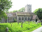 More images
|
| Church of St Michael | Hawkinge | Church/House | 19th century | 29 December 1966 | TR2280839689 51°06′47″N 1°10′55″E / 51.113158°N 1.181901°E |
1242021 |  More images
|
| The Parish Church of St Leonard | Hythe | Parish Church | from circa 1100 | 3 January 1950 | TR1614934915 51°04′22″N 1°05′03″E / 51.07284°N 1.084058°E |
1068961 |  More images
|
| Church of St George | Ivychurch | Parish Church | 13th century | 9 June 1959 | TR0281227665 51°00′45″N 0°53′24″E / 51.012595°N 0.889889°E |
1231321 |  More images
|
| Church of All Saints | Lydd | Parish Church | Saxon | 28 November 1950 | TR0427120953 50°57′06″N 0°54′25″E / 50.951801°N 0.906891°E |
1068932 |  More images
|
| Church of St Mary and St Ethelburga, and remains of the older church to south | Lyminge | Abbey | Circa 633 founded | 29 December 1966 | TR1610740862 51°07′35″N 1°05′13″E / 51.126254°N 1.087016°E |
1242122 |  More images
|
| Church of St Stephen | Lympne | Tower | Late 11th century | 29 December 1966 | TR1197534658 51°04′20″N 1°01′28″E / 51.072088°N 1.024415°E |
1101780 | 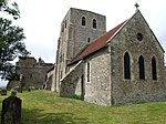 More images
|
| Lympne Castle | Lympne | House | Probably 13th century; mid 14th and 15th centuries, restored early 20th century. | 29 December 1966 | TR1192634661 51°04′20″N 1°01′25″E / 51.072133°N 1.023718°E |
1101773 |  More images
|
| Monks Horton Priory | Monks Horton | House | From 12th century, restored early 20th century. | 29 December 1966 | TR1062639303 51°06′51″N 1°00′28″E / 51.114295°N 1.007894°E |
1084377 |  More images
|
| Church of St Nicholas | New Romney | Church | Medieval | 28 August 1951 | TR0652924751 50°59′06″N 0°56′28″E / 50.985104°N 0.941148°E |
1344057 |  More images
|
| Church of St Peter and St Paul | Newchurch | Parish Church | 13th century | 9 June 1959 | TR0540731351 51°02′41″N 0°55′44″E / 51.044776°N 0.928919°E |
1278140 |  More images
|
| Church of St Clement | Old Romney | Parish Church | 13th century | 9 June 1959 | TR0349525192 50°59′25″N 0°53′54″E / 50.990144°N 0.898228°E |
1278132 | 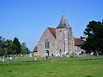 More images
|
| Church of St Oswald | Paddlesworth | Parish Church | 11th century or earlier | 29 December 1966 | TR1950639749 51°06′54″N 1°08′05″E / 51.11497°N 1.134837°E |
1242255 |  More images
|
| Church of St Mary and St Radegund | Postling | Parish Church | late 11th century or 12th century | 29 December 1966 | TR1454539092 51°06′39″N 1°03′49″E / 51.110948°N 1.063676°E |
1356217 |  More images
|
| Bastions and curtain wall about 10 metres south-east of Saltwood Castle | Saltwood | Bailey | Late 14th century | 27 August 1952 | TR1617635915 51°04′55″N 1°05′06″E / 51.081809°N 1.08504°E |
1356140 | 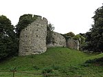 |
| Saltwood Castle | Saltwood | Bailey | possibly 11th century | 27 August 1952 | TR1617435915 51°04′55″N 1°05′06″E / 51.08181°N 1.085012°E |
1344198 |  More images
|
| Sandgate Castle | Sandgate | Castle | 1539–40 | 5 December 1949 | TR2068335173 51°04′24″N 1°08′56″E / 51.073432°N 1.148833°E |
1061237 |  More images
|
| Church of St Mary | Sellindge | Parish Church | Late 11th, 12th, and 13th centuries, restored mid-to-late 19th century | 29 December 1966 | TR0938438452 51°06′26″N 0°59′23″E / 51.107108°N 0.989682°E |
1054042 |  More images
|
| Church of St Thomas a Becket and mounting block attached | Fairfield, Snargate | Parish Church | 15th century, rebuilt 1912–13 | 9 June 1959 | TQ9667126490 51°00′15″N 0°48′07″E / 51.004173°N 0.801821°E |
1277450 | 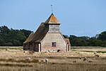 More images
|
| Church of St Mary the Virgin | St. Mary in the Marsh | Parish Church | 12th century | 9 June 1959 | TR0649227990 51°00′51″N 0°56′33″E / 51.014205°N 0.942463°E |
1061102 |  More images
|
| Barns at Westenhanger Manor | Westenhanger, Stanford | Barn | 16th century or earlier | 27 August 1952 | TR1224937198 51°05′41″N 1°01′47″E / 51.094795°N 1.029811°E |
1045888 |  Upload Photo |
| Westenhanger Manor | Westenhanger, Stanford | Castle | 14th century | 27 August 1952 | TR1236537163 51°05′40″N 1°01′53″E / 51.094438°N 1.031445°E |
1344223 | 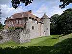 More images
|
| Church of St Mary | Stelling Minnis | Parish Church | Late 12th century or early 13th century | 29 December 1966 | TR1420648592 51°11′47″N 1°03′52″E / 51.196376°N 1.06449°E |
1260110 | 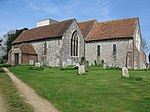 More images
|
| Davison's Mill or Davison's Windmill | Stelling Minnis | Smock Mill | 1866 | 29 December 1966 | TR1462946488 51°10′38″N 1°04′09″E / 51.177326°N 1.069279°E |
1260112 | 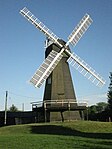 More images
|
| Church of St Peter | Swingfield | Parish Church | Late 11th century or 12th century | 29 December 1966 | TR2328543423 51°08′47″N 1°11′28″E / 51.146496°N 1.191016°E |
1242414 | 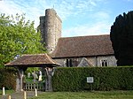 More images
|
See also edit
Notes edit
- ^ The date given is the date used by Historic England as significant for the initial building or that of an important part in the structure's description.
- ^ Sometimes known as OSGB36, the grid reference is based on the British national grid reference system used by the Ordnance Survey.
- ^ The "List Entry Number" is a unique number assigned to each listed building and scheduled monument by Historic England.
References edit
External links edit
![]() Media related to Grade I listed buildings in Folkestone and Hythe at Wikimedia Commons
Media related to Grade I listed buildings in Folkestone and Hythe at Wikimedia Commons