


Summary
There are fourteen Grade I listed buildings in Leicester. In the United Kingdom, the term listed building refers to a building or other structure officially designated as being of special architectural, historical or cultural significance. Grade I structures are those considered to be "buildings of exceptional interest".[1] Listing was begun by a provision in the Town and Country Planning Act 1947. Once listed, severe restrictions are imposed on the modifications allowed to a building's structure or its fittings. In England, the authority for listing under the Planning (Listed Buildings and Conservation Areas) Act 1990[2] rests with Historic England, a non-departmental public body sponsored by the Department for Culture, Media and Sport. Local authorities have a responsibility to regulate and enforce the planning regulations.

0.6miles
There are also ten Scheduled Monuments in Leicester, some of which are also listed buildings.
List of Grade I buildings edit
| Name | Location | Type | Completed [note 1] | Date designated | Grid ref.[note 2] Geo-coordinates | Notes | Entry number [note 3] | Image | Ref. |
|---|---|---|---|---|---|---|---|---|---|
| Leicester Abbey Ruins | 1 Abbey Park |
Ruin | Founded 1143 | 1950 | SK5846806007 52°38′55″N 1°08′14″W / 52.648655°N 1.1372297°W |
Within a public park. Includes a memorial slab to Cardinal Wolsey. | 1074051 |  More images |
[3] |
| Abbot Penny's Wall | 2 Abbey Park |
Wall | c.1500 | 1975 | SK5851306115 52°38′59″N 1°08′12″W / 52.6496°N 1.13655°W |
Forms West and north boundary to Abbey Lane and Abbey Park Road East boundary along River Soar. Some of the earliest medieval brickwork in Leicester. | 1361406 |  More images |
[4] |
| Remains of Cavendish House | 3 Abbey Park |
Ruin | c.1600 | 1950 | SK5840806078 52°38′57″N 1°08′17″W / 52.6493°N 1.1381°W |
Built from stones of Leicester Abbey. Now within the public park. | 1074052 |  More images |
[5] |
| Castle Hall | 4 Castle Yard |
Castle hall | 11th–12th century, front 1695 | 1975 | SK5822204190 52°37′56″N 1°08′28″W / 52.63235°N 1.141185°W |
Includes the Great Hall of Leicester Castle, with its hammer beam roof and Queen Anne frontage, and John of Gaunt's cellar | 1200622 |  |
[6]
|
| Turret Gateway | 5 Castle View |
Fortification | c.1422-3 | 1950 | SK5831204122 52°37′54″N 1°08′24″W / 52.6317°N 1.13987°W |
It gave access from Castle Yard to 'The Newarke'. It is also known as Prince Rupert's Gateway, from his Civil War action, capturing the town. | 1074069 |  More images |
[7] |
| Church of St Mary de Castro | 6 Castle Yard |
Church | From early 13th century | 1950 | SK5828504188 52°37′56″N 1°08′25″W / 52.6323°N 1.14025°W |
Spire dismantled in 2013, with hopes of funding to re-instate it. | 1074070 |  More images |
[8] |
| Former Church of All Saints | 7 High Cross Street |
Church | From early 13th century | 1950 | SK5827404840 52°38′18″N 1°08′25″W / 52.6382°N 1.1403°W |
In the care of the Churches Conservation Trust | 1074012 |  More images |
[9] |
| The Guildhall | 8 Guildhall Lane |
Guildhall | From mid-14th century | 1950 | SK5844404453 52°38′05″N 1°08′16″W / 52.6347°N 1.13786°W |
Served as de facto Town Hall until 1874. Includes the Constable's House. | 1361405 |  More images |
[10] |
| The City Rooms | 9 Hotel Street |
Assembly Rooms | 1792 | 1950 | SK5869904350 52°38′01″N 1°08′03″W / 52.6337°N 1.1341°W |
Architect: John Johnson of Leicester. Name changed from 'County Rooms' when City Council acquired it. | 1184114 | 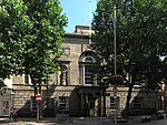 More images |
[11] |
| Church of St Margaret | 10 St Margaret's Way |
Church | Mainly 15th century | 1950 | SK5854205087 52°38′25″N 1°08′11″W / 52.6404°N 1.1363°W |
Transept dates to 1200. Evidence of Anglo-Saxon origins. It now stands on St Margaret's Way (A6), which was built in 1960s, but originally listed as being on Church Gate.) | 1074072 | 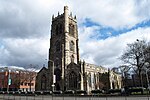 More images |
[12] |
| Jewry Wall | 11 St Nicholas Circle |
Roman masonry | AD 125-30 | 1950 | SK5822404489 52°38′06″N 1°08′28″W / 52.635036°N 1.1411°W |
Among the largest surviving non-military Roman masonry in Britain. Stands alongside excavated remains of Roman Forum. | 1074773 | 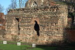 More images |
[13] |
| Church of St Nicholas | 12 St Nicholas Circle |
Church | From AD 880 | 1950 | SK5823804501 52°38′07″N 1°08′27″W / 52.63514°N 1.14089°W |
Incorporates re-used Roman brickwork | 1361046 |  More images |
[14] |
| Magazine Gateway | 13 The Newarke |
fortification | c.1410 | 1950 | SK5844604120 52°37′54″N 1°08′16″W / 52.6317°N 1.13789°W |
Principal gateway to Henry, 3rd Earl of Lancaster's Newarke founded in 1310. | 1184902 |  More images |
[15] |
| The Arch of Remembrance | 14 Victoria Park, Leicester |
War memorial | 1923 | 1955 | SK5956503212 52°37′24″N 1°07′17″W / 52.6234°N 1.1215°W |
Architect: Sir Edwin Lutyens | 1074786 |  More images |
[16] |
Notes edit
- ^ The date given is the date used by Historic England as significant for the initial building or that of an important part in the structure's description.
- ^ Sometimes known as OSGB36, the grid reference is based on the British national grid reference system used by the Ordnance Survey.
- ^ The "List Entry Number" is a unique number assigned to each listed building and scheduled monument by Historic England.
References edit
- ^ "What is a listed building?". Manchester City Council. Retrieved 8 December 2007.
- ^ "Planning (Listed Buildings and Conservation Areas) Act 1990 (c. 9)". Ministry of Justice. Retrieved 17 December 2007.
- ^ Historic England. "Abbey Ruins (1074051)". National Heritage List for England. Retrieved 31 January 2015.
- ^ Historic England. "Abbot Penny's Wall (1361406)". National Heritage List for England. Retrieved 31 January 2015.
- ^ Historic England. "Remains of Cavendish House (1074052)". National Heritage List for England. Retrieved 31 January 2015.
- ^ Historic England. "Castle Hall, Leicester Castle and John of Gaunt's cellar (1200622)". National Heritage List for England. Retrieved 31 January 2015.
- ^ Historic England. "Turret Gateway (1074069)". National Heritage List for England. Retrieved 31 January 2015.
- ^ Historic England. "Church of St Mary de Castro (1074070)". National Heritage List for England. Retrieved 31 January 2015.
- ^ Historic England. "Former Church of All Saints (1074012)". National Heritage List for England. Retrieved 31 January 2015.
- ^ Historic England. "The Guildhall (1361405)". National Heritage List for England. Retrieved 31 January 2015.
- ^ Historic England. "The City Rooms (1184114)". National Heritage List for England. Retrieved 31 January 2015.
- ^ Historic England. "St Margaret's Church (listed as Church Gate) (1074072)". National Heritage List for England. Retrieved 31 January 2015.
- ^ Historic England. "Jewry Wall (1074773)". National Heritage List for England. Retrieved 31 January 2015.
- ^ Historic England. "St Nicholas's Church (1361046)". National Heritage List for England. Retrieved 31 January 2015.
- ^ Historic England. "Magazine Gateway (1184902)". National Heritage List for England. Retrieved 31 January 2015.
- ^ Historic England. "The Arch of Remembrance (1074786)". National Heritage List for England. Retrieved 20 December 2018.
See also edit
External links edit
- Full list of listed buildings in Leicester