
KNOWPIA
WELCOME TO KNOWPIA

Grade I listed buildings in Tonbridge and Malling 
Summary
There are over 9,000 Grade I listed buildings in England. This page is a list of these buildings in the district of Tonbridge and Malling in Kent.
Tonbridge and Malling edit
| Name | Location | Type | Completed [note 1] | Date designated | Grid ref.[note 2] Geo-coordinates |
Entry number [note 3] | Image |
|---|---|---|---|---|---|---|---|
| Church of St Margaret | Addington, Tonbridge and Malling | Church | c. 1100 | 25 August 1959 | TQ6538558879 51°18′18″N 0°22′16″E / 51.305005°N 0.371214°E |
1070567 |  More images
|
| Aylesford Bridge | Aylesford | Bridge | 14th century | 25 August 1959 | TQ7294158927 51°18′11″N 0°28′46″E / 51.303192°N 0.479528°E |
1363113 | 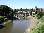 More images
|
| Church of St Peter | Aylesford | Church | 12th century | 25 August 1959 | TQ7293959032 51°18′15″N 0°28′46″E / 51.304136°N 0.47955°E |
1337029 | 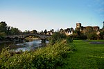 More images
|
| Gatehouse and Walls to the North and East of the Friars | Aylesford | Wall | 15th century | 25 February 1987 | TQ7240358930 51°18′12″N 0°28′19″E / 51.303382°N 0.471819°E |
1111775 |  |
| The Friars, Main Block | Aylesford | Manor House | 15th century | 25 August 1959 | TQ7239658860 51°18′10″N 0°28′18″E / 51.302755°N 0.471685°E |
1070570 |  |
| Church of All Saints | Birling | Manor House | Early 14th century | 25 August 1959 | TQ6801960604 51°19′11″N 0°24′35″E / 51.319731°N 0.409777°E |
1070519 |  More images
|
| Church of St Mary the Virgin | Burham | Church | C12-C15 | 25 August 1959 | TQ7166062008 51°19′53″N 0°27′46″E / 51.331258°N 0.462652°E |
1070523 |  More images
|
| Bradbourne House | East Malling and Larkfield | Manor House | 17th century | 1 August 1952 | TQ7036257909 51°17′41″N 0°26′31″E / 51.294824°N 0.442082°E |
1070507 |  More images
|
| Church of St James | East Malling and Larkfield | Church | 12th century | 25 August 1959 | TQ7029457080 51°17′15″N 0°26′27″E / 51.287397°N 0.440713°E |
1099148 |  More images
|
| Clare House | East Malling and Larkfield | House | 1793 | 1 August 1952 | TQ6947357736 51°17′37″N 0°25′45″E / 51.293535°N 0.429262°E |
1099100 |  Upload Photo |
| Stable Block and Barns 40 Yards North of Bradbourne House | East Malling and Larkfield | Barn | 19th century | 1 August 1952 | TQ7034157965 51°17′43″N 0°26′31″E / 51.295333°N 0.441808°E |
1348523 | Upload Photo |
| Barnes Place | Golden Green, Hadlow | Kitchen | 18th century OR 19th century | 20 October 1954 | TQ6459248116 51°12′31″N 0°21′18″E / 51.208537°N 0.3549°E |
1363161 | Upload Photo |
| Hadlow Castle | Hadlow | House | 1951 | 17 April 1951 | TQ6341949639 51°13′21″N 0°20′20″E / 51.222557°N 0.338816°E |
1070451 |  More images
|
| Church of St Peter | Ightham | Church | c. 1400 | 25 August 1959 | TQ5948456930 51°17′21″N 0°17′09″E / 51.289176°N 0.285762°E |
1071962 |  More images
|
| Ightham Mote | Ightham | House | At least 1340-1360 | 1 August 1952 | TQ5847653485 51°15′31″N 0°16′11″E / 51.258505°N 0.269792°E |
1362410 |  More images
|
| Church of St Lawrence | Mereworth | Parish Church | 1744-1746 | 25 August 1959 | TQ6601853752 51°15′32″N 0°22′40″E / 51.258759°N 0.377906°E |
1186214 |  More images
|
| Mereworth Castle (main Block) | Mereworth | House | 18th century | 1 August 1952 | TQ6689553230 51°15′14″N 0°23′25″E / 51.253814°N 0.390219°E |
1070675 | 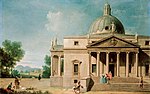 More images
|
| Pavilion to the North East of Mereworth Castle | Mereworth | Pavilion | Circa 1740-1750 | 1 August 1952 | TQ6694253276 51°15′15″N 0°23′27″E / 51.254213°N 0.390914°E |
1363025 |  |
| Pavilion to the North West and Stables of Mereworth Castle | Mereworth | Manor House | 1740-1750 | 1 August 1952 | TQ6686253285 51°15′16″N 0°23′23″E / 51.254318°N 0.389773°E |
1070676 | |
| Yotes Court | Mereworth | Country House | 1656-1658 | 19 April 1985 | TQ6501553307 51°15′18″N 0°21′48″E / 51.255052°N 0.363339°E |
1363026 | 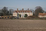 More images
|
| Church of St Michael | Offham | Church | c. 1100 | 25 August 1959 | TQ6602958063 51°17′51″N 0°22′48″E / 51.297486°N 0.380065°E |
1264787 | 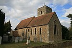 More images
|
| Fairlawne | Plaxtol | Country House | Before 1840 | 1 August 1952 | TQ5943653430 51°15′28″N 0°17′01″E / 51.257743°N 0.283514°E |
1072711 |  More images
|
| Old Soar Manor | Plaxtol | Farmhouse | 18th century | 3 May 1984 | TQ6195054103 51°15′47″N 0°19′11″E / 51.263082°N 0.319816°E |
1281122 | 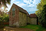 More images
|
| Church of All Saints | Snodland | Parish Church | 12th century | 25 August 1959 | TQ7076161822 51°19′47″N 0°26′59″E / 51.329857°N 0.449671°E |
1347897 |  More images
|
| Church of St Peter and St Paul | Trottiscliffe | Church | c. 1200 | 25 August 1959 | TQ6463460544 51°19′13″N 0°21′40″E / 51.320181°N 0.361218°E |
1236191 |  More images
|
| Gatehouse and Chapel to St Mary's Abbey | West Malling, Tonbridge and Malling | Abbey | Late 15th century or early 16th century | 25 August 1959 | TQ6822257740 51°17′38″N 0°24′41″E / 51.293941°N 0.411338°E |
1209130 | 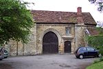 More images
|
| St Leonard's Tower | West Malling | Bishops Palace | 1077-1108 | 30 November 1993 | TQ6759157081 51°17′18″N 0°24′07″E / 51.288207°N 0.401988°E |
1219087 |  More images
|
| St Mary's Abbey Chapterhouse and Library | West Malling | Abbey | Norman | 25 August 1959 | TQ6829157677 51°17′36″N 0°24′44″E / 51.293355°N 0.412297°E |
1291520 | Upload Photo |
| St Marys Abbey Convent Building | West Malling | Abbey | 1735 | 25 August 1959 | TQ6827157667 51°17′36″N 0°24′43″E / 51.293271°N 0.412006°E |
1209132 | Upload Photo |
| St Mary's Abbey North Wall of Cloister | West Malling | Abbey | c. 1090 | 25 August 1959 | TQ6827557692 51°17′37″N 0°24′43″E / 51.293495°N 0.412075°E |
1291527 | Upload Photo |
| St Mary's Abbey Tower to Original Abbey | West Malling | Abbey | Early Norman | 25 August 1959 | TQ6826257703 51°17′37″N 0°24′43″E / 51.293597°N 0.411894°E |
1292791 | Upload Photo |
| The Ancient House | West Malling | Merchants House | 15th century | 1 August 1952 | TQ6805457787 51°17′40″N 0°24′32″E / 51.294413°N 0.408953°E |
1292809 | Upload Photo |
| Church of St Dunstan | West Peckham | Church | Saxon | 25 August 1959 | TQ6442652574 51°14′55″N 0°21′16″E / 51.248637°N 0.35457°E |
1070669 |  More images
|
| Dukes Place | West Peckham | Manor House | 18th century | 1 August 1952 | TQ6483652687 51°14′58″N 0°21′38″E / 51.249534°N 0.360491°E |
1070672 |  More images
|
| Church of All Saints | Wouldham | Church | 11th century | 25 August 1959 | TQ7126364391 51°21′10″N 0°27′29″E / 51.352785°N 0.458105°E |
1070490 |  More images
|
| Starkey Castle | Wouldham | House | 1952 | 1 August 1952 | TQ7138365592 51°21′49″N 0°27′37″E / 51.363538°N 0.460404°E |
1347808 |  More images
|
| Church of St George | Wrotham | Church | Early 14th century | 25 August 1959 | TQ6118359189 51°18′32″N 0°18′40″E / 51.308994°N 0.311125°E |
1236562 |  More images
|
| Tonbridge Castle | Tonbridge and Malling | Keep | Norman | 8 May 1950 | TQ5897446602 51°11′47″N 0°16′26″E / 51.196524°N 0.273873°E |
1363369 |  More images
|
Notes edit
- ^ The date given is the date used by Historic England as significant for the initial building or that of an important part in the structure's description.
- ^ Sometimes known as OSGB36, the grid reference is based on the British national grid reference system used by the Ordnance Survey.
- ^ The "List Entry Number" is a unique number assigned to each listed building and scheduled monument by Historic England.
External links edit
![]() Media related to Grade I listed buildings in Tonbridge and Malling at Wikimedia Commons
Media related to Grade I listed buildings in Tonbridge and Malling at Wikimedia Commons