


Summary
Kuznechnoye (Russian: Кузне́чное; Finnish: Kaarlahti) is an urban locality (an urban-type settlement) in the northern part of Priozersky District of Leningrad Oblast, located on the Karelian Isthmus. Population: 4,458 (2010 Russian census);[3] 4,738 (2002 Census);[8] 5,017 (1989 Soviet census).[9]
Kuznechnoye
Кузнечное | |
|---|---|
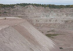 Kuznechnoye granite quarry | |
Location of Kuznechnoye .mw-parser-output .locmap .od{position:absolute}.mw-parser-output .locmap .id{position:absolute;line-height:0}.mw-parser-output .locmap .l0{font-size:0;position:absolute}.mw-parser-output .locmap .pv{line-height:110%;position:absolute;text-align:center}.mw-parser-output .locmap .pl{line-height:110%;position:absolute;top:-0.75em;text-align:right}.mw-parser-output .locmap .pr{line-height:110%;position:absolute;top:-0.75em;text-align:left}.mw-parser-output .locmap .pv>div{display:inline;padding:1px}.mw-parser-output .locmap .pl>div{display:inline;padding:1px;float:right}.mw-parser-output .locmap .pr>div{display:inline;padding:1px;float:left}html.skin-theme-clientpref-night .mw-parser-output .od,html.skin-theme-clientpref-night .mw-parser-output .od .pv>div,html.skin-theme-clientpref-night .mw-parser-output .od .pl>div,html.skin-theme-clientpref-night .mw-parser-output .od .pr>div{background:#000;color:#fff}html.skin-theme-clientpref-night .mw-parser-output .locmap{filter:grayscale(0.6)}@media(prefers-color-scheme:dark){html.skin-theme-clientpref-os .mw-parser-output .locmap{filter:grayscale(0.6)}html.skin-theme-clientpref-os .mw-parser-output .od,html.skin-theme-clientpref-os .mw-parser-output .od .pv>div,html.skin-theme-clientpref-os .mw-parser-output .od .pl>div,html.skin-theme-clientpref-os .mw-parser-output .od .pr>div{background:#000;color:#fff}}  Kuznechnoye Location of Kuznechnoye 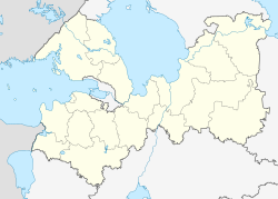 Kuznechnoye Kuznechnoye (Leningrad Oblast) | |
| Coordinates: 61°07′N 29°52′E / 61.117°N 29.867°E | |
| Country | Russia |
| Federal subject | Leningrad Oblast |
| Administrative district | Priozersky District[1] |
| Urban-type settlement status since | 1961[2] |
| Population | |
| • Total | 4,458 |
| • Estimate (2018)[4] | 4,182 (−6.2%) |
| • Municipal district | Priozersky Municipal District[5] |
| • Urban settlement | Kuznechninskoye Urban Settlement[5] |
| • Capital of | Kuznechninskoye Urban Settlement[5] |
| Time zone | UTC+3 (MSK |
| Postal code(s)[7] | 188751 |
| OKTMO ID | 41639154051 |
History edit
The village of Kaarlahti was known since at least the 16th century and belonged interchangeably to Russia and Sweden. Since the middle of the 18th century, it was a part of Vyborg Governorate, which, in turn, since 1812 was a part of the Grand Duchy of Finland as the Viipuri Province. In 1916, the railway station was opened. In 1918, together with the rest of the Viipuri Province, Kaarlahti became a part of independent Finland. After the Winter War, it was reclaimed by the Soviet Union.[2] Kaarlahti became a part of Keksgolmsky District with the administrative center in Keksgolm which was a part of the Karelian Autonomous Soviet Socialist Republic (Karelian ASSR). On March 31, 1940, the Karelian ASSR was transformed into the Karelo-Finnish Soviet Socialist Republic. During the Second World War, Kaarlahti was reclaimed by Finland and then again ceded to the Soviet Union. On November 24, 1944, Keksgolmsky District was transferred from Karelo-Finnish Soviet Socialist Republic to Leningrad Oblast.[10]
In the end of 1944 a large granite quarry and processing plant (now belonging to JSC Granit-Kuznechnoye) was developed, and Kaarlahti started to grow steadily. In 1948, the station was renamed Granitnaya, and the settlement was renamed Kuznetsy, subsequently Kuznechnaya. On January 13, 1949 the settlement was renamed Kuznechnoye. In 1961, it was granted urban-type settlement status.[2]
Economy edit
The economy of the settlement is based on granite production. There are several quarries surrounding Kuznechnoye.
Transportation edit
Kuznechnoye is also an important station of the Saint Petersburg-Khiytola railroad, being the final destination of many passenger trains coming from Finlyandsky Rail Terminal of St. Petersburg (about 3 h 25 min as of 2007) and from Sortavala (about 2 h 45 min as of 2007) and a stop of the St. Petersburg–Kostomuksha trains.
Kuznechnoye is connected by road with Melnikovo and also has access to the A129 highway, which connects Saint Petersburg and Sortavala.
Tourism edit
Kuznechnoye's rocky outskirts are a popular climbing area and tourist destination.[2]
References edit
Notes edit
- ^ a b Государственный комитет Российской Федерации по статистике. Комитет Российской Федерации по стандартизации, метрологии и сертификации. №ОК 019-95 1 января 1997 г. «Общероссийский классификатор объектов административно-территориального деления. Код 41 239 554 001», в ред. изменения №278/2015 от 1 января 2016 г.. (State Statistics Committee of the Russian Federation. Committee of the Russian Federation on Standardization, Metrology, and Certification. #OK 019-95 January 1, 1997 Russian Classification of Objects of Administrative Division (OKATO). Code 41 239 554 001, as amended by the Amendment #278/2015 of January 1, 2016. ).
- ^ a b c d e Dmitriyev, Andrey. История посёлка Кузнечное (in Russian). Kuznechnoye Municipal Formation. Archived from the original on July 7, 2013. Retrieved June 28, 2013.
- ^ a b Russian Federal State Statistics Service (2011). Всероссийская перепись населения 2010 года. Том 1 [2010 All-Russian Population Census, vol. 1]. Всероссийская перепись населения 2010 года [2010 All-Russia Population Census] (in Russian). Federal State Statistics Service.
- ^ "26. Численность постоянного населения Российской Федерации по муниципальным образованиям на 1 января 2018 года". Federal State Statistics Service. Retrieved January 23, 2019.
- ^ a b c Law #17-oz
- ^ "Об исчислении времени". Официальный интернет-портал правовой информации (in Russian). June 3, 2011. Retrieved January 19, 2019.
- ^ Почта России. Информационно-вычислительный центр ОАСУ РПО. (Russian Post). Поиск объектов почтовой связи (Postal Objects Search) (in Russian)
- ^ Federal State Statistics Service (May 21, 2004). Численность населения России, субъектов Российской Федерации в составе федеральных округов, районов, городских поселений, сельских населённых пунктов – районных центров и сельских населённых пунктов с населением 3 тысячи и более человек [Population of Russia, Its Federal Districts, Federal Subjects, Districts, Urban Localities, Rural Localities—Administrative Centers, and Rural Localities with Population of Over 3,000] (XLS). Всероссийская перепись населения 2002 года [All-Russia Population Census of 2002] (in Russian).
- ^ Всесоюзная перепись населения 1989 г. Численность наличного населения союзных и автономных республик, автономных областей и округов, краёв, областей, районов, городских поселений и сёл-райцентров [All Union Population Census of 1989: Present Population of Union and Autonomous Republics, Autonomous Oblasts and Okrugs, Krais, Oblasts, Districts, Urban Settlements, and Villages Serving as District Administrative Centers]. Всесоюзная перепись населения 1989 года [All-Union Population Census of 1989] (in Russian). Институт демографии Национального исследовательского университета: Высшая школа экономики [Institute of Demography at the National Research University: Higher School of Economics]. 1989 – via Demoscope Weekly.
- ^ Кексгольмский район (нояб. 1944 - окт.1948), Приозерский район (окт.1948 – февр.1963, янв.1965) (in Russian). Система классификаторов исполнительных органов государственной власти Санкт-Петербурга. Archived from the original on March 13, 2014. Retrieved June 20, 2013.
Sources edit
- Законодательное собрание Ленинградской области. Областной закон №32-оз от 15 июня 2010 г. «Об административно-территориальном устройстве Ленинградской области и порядке его изменения», в ред. Областного закона №23-оз от 8 мая 2014 г. «Об объединении муниципальных образований "Приморское городское поселение" Выборгского района Ленинградской области и "Глебычевское сельское поселение" Выборгского района Ленинградской области и о внесении изменений в отдельные Областные законы». Вступил в силу со дня официального опубликования. Опубликован: "Вести", №112, 23 июня 2010 г. (Legislative Assembly of Leningrad Oblast. Oblast Law #32-oz of June 15, 2010 On the Administrative-Territorial Structure of Leningrad Oblast and on the Procedures for Its Change, as amended by the Oblast Law #23-oz of May 8, 2014 On Merging the Municipal Formations of "Primorskoye Urban Settlement" in Vyborgsky District of Leningrad Oblast and "Glebychevskoye Rural Settlement" in Vyborgsky District of Leningrad Oblast and on Amending Various Oblast Laws. Effective as of the day of the official publication.).
- Законодательное собрание Ленинградской области. Областной закон №50-оз от 1 сентября 2004 г. «Об установлении границ и наделении соответствующим статусом муниципального образования Приозерский муниципальный район и муниципальных образований в его составе», в ред. Областного закона №43-оз от 27 июня 2013 г. «О присоединении деревни Большая Загвоздка к городу Гатчина и о внесении изменений в некоторые Областные законы в сфере административно-территориального устройства Ленинградской области». Вступил в силу через 10 дней со дня официального опубликования (24 сентября 2004 г.). Опубликован: "Вестник Правительства Ленинградской области", №27, 14 сентября 2004 г. (Legislative Assembly of Leningrad Oblast. Oblast Law #50-oz of September 1, 2004 On Establishing the Borders of and Granting an Appropriate Status to the Municipal Formation of Priozersky Municipal District and to the Municipal Formations Comprised By It, as amended by the Oblast Law #43-oz of June 27, 2013 On Merging the Village of Bolshaya Zagvozdka into the Town of Gatchina and on Amending Various Oblast Laws on the Subject of the Administrative-Territorial Structure of Leningrad Oblast. Effective as of after 10 days from the day of the official publication (September 24 2004).).