
KNOWPIA
WELCOME TO KNOWPIA

Palestine Township, Cooper County, Missouri 
Summary
Palestine Township is one of fourteen townships in Cooper County, Missouri, USA. As of the 2000 census, its population was 367.[1]
Palestine Township | |
|---|---|
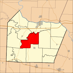 Location in Cooper County | |
| Coordinates: 38°51′16″N 92°50′31″W / 38.85444°N 92.84194°W | |
| Country | |
| State | |
| County | Cooper |
| Area | |
| • Total | 44.97 sq mi (116.48 km2) |
| • Land | 44.92 sq mi (116.34 km2) |
| • Water | 0.06 sq mi (0.15 km2) 0.13% |
| Elevation | 745 ft (227 m) |
| Population (2000) | |
| • Total | 367 |
| • Density | 8.2/sq mi (3.2/km2) |
| Time zone | UTC-6 (CST) |
| • Summer (DST) | UTC-5 (CDT) |
| ZIP codes | 65233, 65237, 65276 |
| GNIS feature ID | 0766535 |
Geography edit
According to the United States Census Bureau, Palestine Township covers an area of 44.97 square miles (116.48 square kilometers); of this, 44.92 square miles (116.34 square kilometers, 99.88 percent) is land and 0.06 square miles (0.15 square kilometers, 0.13 percent) is water.
Unincorporated towns edit
- Bellair at 38°49′59″N 92°50′40″W / 38.833078°N 92.844359°W
- Speed at 38°50′53″N 92°48′12″W / 38.848079°N 92.803247°W
(This list is based on USGS data and may include former settlements.)
Adjacent townships edit
- Boonville Township (northeast)
- Clark Fork Township (east)
- Kelly Township (south)
- Lebanon Township (southwest)
- Clear Creek Township (west)
- Pilot Grove Township (northwest)
Cemeteries edit
The township contains these three cemeteries: Briscoe, Concord and Concord.
Major highways edit
School districts edit
- Boonville School District
- Cooper County C-4
- Pilot Grove C-4
Political districts edit
- Missouri's 6th congressional district
- State House District 117
- State Senate District 21
References edit
- United States Census Bureau 2008 TIGER/Line Shapefiles
- United States Board on Geographic Names (GNIS)
- United States National Atlas
- ^ "U.S. Census website". Retrieved May 13, 2009.
External links edit
- US-Counties.com
- City-Data.com