


Summary
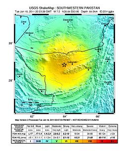
The 2011 Dalbandin earthquake occurred on 19 January at 01:23 a.m. local time with a moment magnitude of Mw 7.2 and a maximum Mercalli intensity of VII (Very strong). The shock occurred in a sparsely populated area of Balochistan, caused moderate damage, three deaths, and some injuries.
 | |
 Kabul Islamabad Delhi Karachi | |
| UTC time | 2011-01-18 20:23:23 |
|---|---|
| ISC event | 15938045 |
| USGS-ANSS | ComCat |
| Local date | 19 January 2011 |
| Local time | 01:23:23 PKT |
| Magnitude | 7.2 Mw[1] |
| Depth | 90 km (55.9 mi)[1] |
| Epicenter | 28°45′N 64°03′E / 28.75°N 64.05°E[1] |
| Type | Dip-slip[2] |
| Areas affected | Pakistan |
| Total damage | Moderate[3] |
| Max. intensity | MMI VII (Very strong)[2] |
| Casualties | 3 killed, some injured[3] |
Earthquake edit
The tectonic environment of this region is dominated by the motions of the Arabian Plate, the Indian Plate, and the Eurasian Plate. This earthquake occurred as a result of normal faulting within the lithosphere of the subducted Arabian Plate.[2]
Damage edit
About 200 mud houses, including some government offices were reported damaged in the Dalbandin area of Pakistan.[4][5][6] Two women died of heart attacks in Quetta after the earthquake, about 330 km northeast of the epicenter, where the Mercalli intensity was IV (Light).[7][8]
Intensity edit
Tremors after the earthquake reached neighboring countries[4] including Bahrain, UAE, Oman, Iran, Afghanistan, and India. It was felt with a Mercali intensity of IV (Light) in Islamabad, Karachi, Muscat, Delhi, and III (Weak) in Kabul, Dubai, and Abu Dhabi.[2]
See also edit
References edit
- ^ a b c ISC (2016), ISC-GEM Global Instrumental Earthquake Catalogue (1900–2012), Version 3.0, International Seismological Centre
- ^ a b c d USGS. "M 7.2 - 46 km WSW of Dalbandin, Pakistan". United States Geological Survey.
- ^ a b National Geophysical Data Center / World Data Service (NGDC/WDS) (1972), Significant Earthquake Information (Data Set), National Geophysical Data Center, NOAA, doi:10.7289/V5TD9V7K
- ^ a b Martin, S. S.; Kakar, D. M. (1 August 2012). "The 19 January 2011 Mw 7.2 Dalbandin Earthquake, Balochistan". Bulletin of the Seismological Society of America. 102 (4): 1810–1819. Bibcode:2012BuSSA.102.1810M. doi:10.1785/0120110221. ISSN 0037-1106.
- ^ "Homes damaged after Pakistan earthquake". CNN. 18 January 2011. Retrieved 22 January 2011.
- ^ "Leading News Resource of Pakistan". Daily Times. Archived from the original on 25 May 2012. Retrieved 22 January 2011.
- ^ "Un muerto y varios heridos por terremoto en Pakistán" (in Spanish). El Economista. 18 January 2011. Retrieved 22 January 2011.
- ^ Ali, Saeed (12 December 2010). "Major quake rattles Pakistan | World | News". Toronto Sun. Archived from the original on 11 December 2013.
Further reading edit
External links edit
- Major earthquake strikes southwestern Pakistan – CNN
- Dalbandin, Pakistan Earthquake of 18 January 2011, Mw 7.2 – IIEES
- Pakistan: Post-Earthquake Assessment for Town of Dalbandin, Balochistan (28 Jan 2011) – ReliefWeb
- The International Seismological Centre has a bibliography and/or authoritative data for this event.