


Summary
The Adamawa Plateau (French: Massif de l'Adamaoua) is a plateau region in west-central Africa stretching from south-eastern Nigeria through north-central Cameroon (Adamawa and North Provinces) to the Central African Republic.[1] The part of the plateau that lies in Nigeria is more popularly known as Gotel Mountains.
| Adamawa Plateau | |
|---|---|
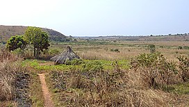 Landscape near Ngaoundal in Cameroon's Adamawa Province | |
| Highest point | |
| Elevation | 2,650 m (8,690 ft)[1] |
| Coordinates | 9°48′N 14°05′E / 9.800°N 14.083°E |
| Geography | |
| Countries | Cameroon, Central African Republic and Nigeria |
The Adamawa Plateau is the source of many waterways, including the Benue River. The average elevation is about 3,300 feet (1,000 meters),[2] but elevations can reach as high as 8,700 feet (2,700 meters).[1] It is important for its deposits of bauxite.[1] The vegetation is mostly savanna. The endangered toad Amietophrynus djohongensis is known to exist in the wild only in the Cameroonian part of the Adamawa Plateau.[3][4]
The plateau is sparsely populated, and cattle raising is the main occupation in the area.[2] The province and plateau were named after Fulani Muslim leader Modibo Adama, whose jihads significantly affected the population of the area.[2]
References edit
- ^ a b c d "Encyclopædia Britannica - Adamawa Plateau". Archived from the original on 15 October 2007. Retrieved September 15, 2007.
- ^ a b c "MSN Encarta - Adamawa Plateau". Archived from the original on 2009-11-02. Retrieved September 15, 2007.
- ^ Joger, U.; Tandy, M. & Amiet, J.-L. (2004). "Amietophrynus djohongensis". IUCN Red List of Threatened Species. 2004. IUCN: e.T54630A11178521. doi:10.2305/IUCN.UK.2004.RLTS.T54630A11178521.en.
- ^ Frost, Darrel R. (2015). "Amietophrynus djohongensis (Hulselmans, 1977)". Amphibian Species of the World: an Online Reference. Version 6.0. American Museum of Natural History. Retrieved 23 October 2015.