


Summary
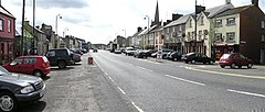
Aughnacloy, sometimes spelt Auchnacloy (Irish: Achadh na Cloiche, meaning 'field of the stone'[1]), is a village in County Tyrone, Northern Ireland. Close to the border with County Monaghan in the Republic of Ireland, the village is about 20 km southwest of Dungannon, and 7 km southeast of Ballygawley. It is situated in the historic barony of Dungannon Lower and the civil parish of Carnteel.[2] In the 2011 Census it had a population of 1,045.[3]
Aughnacloy
| |
|---|---|
 | |
 Location within Northern Ireland | |
| Population | 1,045 (2011 Census) |
| Irish grid reference | H665521 |
| • Belfast | 52 mi (84 km) |
| District | |
| County | |
| Country | Northern Ireland |
| Sovereign state | United Kingdom |
| Post town | AUGHNACLOY |
| Postcode district | BT69 |
| Dialling code | 028 |
| UK Parliament | |
| NI Assembly | |
History edit
Much of the town was built in the 18th Century by Acheson Moore, the local landlord. Because he backed the Jacobite cause, he planted his estate in the shape of a thistle and planned out the town on the edge of it.[4] Unable to rename it "Mooretown", he had to settle for naming the main street "Moore Street", and the side streets Sydney, Lettice, and Henrietta (now Ravella Road), after his three wives. The thistle is still visible from the air.[5]
Aughnacloy served as an important staging post on the road to Derry.[6] However, lacking large-scale industry, it started to wane in the late 19th century.


The Troubles edit
In 1988, Aidan McAnespie, a Catholic civilian, was killed by a bullet from a general purpose machine-gun held by a British Army soldier at Aughnacloy. In June 2008, the PSNI Historical Enquiries Team published its findings on the case in a report.[7]
Demographics edit
2011 Census edit
At the time of the 2011 census (27 March 2011), Aughnacloy had a population of 1,045, accounting for 0.06% of the total NI population.[8] Of those 1,045 people:
- 99.14% were from the white (including Irish Traveller) ethnic group
- 56.84% belong to or were brought up in the Catholic religion and 41.34% belong to or were brought up in a 'Protestant and Other Christian (including Christian related)' religion
- 35.41% indicated that they had a British national identity, 30.62% had an Irish national identity and 22.39% had a Northern Irish national identity*.
- 14.81% had some knowledge of Irish
- 5.17% had some knowledge of Ulster-Scots
- 15.62% did not have English as their first language
Transport edit
Aughnacloy had its own railway station on the Clogher Valley Railway (CVR) from 2 May 1887 to 1 January 1942.[9] The CVR's headquarters and locomotive workshop was also at Aughnacloy. Current proposals to upgrade the A5 road through the village to a dual carriageway and build a bypass have met with a mixed reaction in the town, with many traders and farmers strongly opposed. [citation needed]
The town is served by Bus Eireann Expressway Route 32, connecting the town to both Dublin and Letterkenny.
Education edit
- Aughnacloy Primary School
- Aughnacloy College (former names: Aughnacloy Secondary School; Aughnacloy High School) opened in 1963, designed by John MacGeagh. It occupies a rural site on the outskirts of Aughancloy, serving a catchment area stretching along the Blackwater valley including Caledon, Greystone, Innismagh, Ballygawley, Lisdoart and Favour Royal
- St. Mary's Primary School, Aughnacloy
Sport edit
- Aghaloo O'Neills – Gaelic Athletic Association club.
- Aughnacloy Golf Club – one of the founder clubs of the Golfing Union of Ireland in 1890; reformed in 1994 and currently based at Lissenderry just outside the village[citation needed]
- Aughnacloy Races – The ancient tradition of horse racing has been re-established in recent years[citation needed]
Notable people edit
See also edit
References edit
- ^ "Aughnacloy". Place Names NI. Retrieved 18 March 2013.
- ^ "Townlands of County Tyrone". IreAtlas Townland Database. Retrieved 28 December 2012.
- ^ "Census 2011 Population Statistics for Aughnacloy Settlement". Northern Ireland Statistics and Research Agency (NISRA). Retrieved 2 May 2021.
 This article contains quotations from this source, which is available under the Open Government Licence v3.0. © Crown copyright.
- ^ Campbell, Thomas (1778). A philosophical survey of the south of Ireland, : in a series of letters to John Watkinson, M.D. Dublin. pp. 35–36. LCCN 04022125. OCLC 504801. Retrieved 6 April 2022.
- ^ Given, Anne (1988). "A Little-Known Curiosity in County Tyrone". Archaeology Ireland. 2 (1): 12-14. Retrieved 22 September 2022.
- ^ Lewis, Samuel (1837). A topographical dictionary of Ireland. London: S. Lewis & Co. pp. 95–96. Retrieved 4 October 2022.
- ^ "Checkpoint death report welcomed". BBC News NI. 24 June 2008. Retrieved 24 June 2008.
- ^ "Census 2011 Population Statistics for Aughnacloy Settlement". NISRA. Retrieved 29 September 2022.
- ^ "Aughnacloy station" (PDF). Railscot – Irish Railways. p. 3. Archived (PDF) from the original on 26 September 2007. Retrieved 9 September 2007.
Sources edit
- Dungannon & South Tyrone Area Plan 2010