


Summary
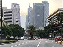
Ayala Avenue is a major thoroughfare in Makati, the Philippines. It is one of the busiest roads in Metro Manila, crossing through the heart of the Makati Central Business District. Because of the many businesses located along the avenue, Ayala Avenue is nicknamed the "Wall Street of the Philippines" and dubbed in the 1970s and 1980s as the "Madison Avenue of the Philippines".[1][2]
 | |
| Namesake | Zóbel de Ayala family |
|---|---|
| Length | 2.3 km (1.4 mi) |
| Restrictions | Trucks, pedicabs, and tricycles not allowed between Gil Puyat Avenue and EDSA |
| Location | Makati |
| North end | Metropolitan Avenue |
| Major junctions | |
| South end | |
| Construction | |
| Completion | 1950s |
History edit

Ayala Avenue's segment from the present-day Gil Puyat (Buendia) Avenue to Makati Avenue used to be the primary runway of the Nielson Airport, which was inaugurated in 1937 and was one of the first airports built in Luzon, while its extension occupies a segment of an old road that connected the Santa Ana Park and McKinley–Pasay Road.[3][4][5] The airport was destroyed during the Japanese occupation of the Philippines on December 10, 1941, and resumed operations after the end World War II in 1947. The airport closed in 1948 and its permanent facilities were passed on the owner of the land, Ayala y Compañía. The runways were then converted into roads as part of Ayala's plan to build a new business district in the area.[6] The modern avenue was completed in the mid-1950s,[7] eventually connecting it to Highway 54 (now EDSA).[8]
It later created a new segment between Kamagong Street in San Antonio Village and Metropolitan Avenue, connecting it to South Avenue.[9] In 1998, a flyover was built for left turners onto EDSA northbound.[10]
The avenue was also once a component road of Circumferential Road 3 of Manila's arterial road network.[11]
Bicycle lanes edit

In 2020, in response to the growing popularity of bicycle commuting and ownership amidst the COVID-19 pandemic, the Makati Central Estate Association (MaCEA) and Ayala Land through its Make it Makati campaign designated 3-meter-wide (9.8 ft) bicycle lanes along Ayala Avenue from Gil Puyat Avenue to EDSA, protected by bollards and exclusive to non-motorized bicycles and scooters. Bicycle boxes were also added to intersections to allow left-turns. The lanes underwent a trial run on August 7, 2020, and were completed on September 7, 2020. Following this, designated stops for public transport services were also moved to the middle lane of the road.[12]
edit
On February 10, 2023, Make It Makati announced that the Ayala Avenue bicycle lanes would be changed into sharrows starting February 15, 2023, allowing both motor vehicles and public transport vehicles to use the lane.[13][14] This announcement was met with opposition from cyclists, commuters, and several organizations, who argued that the removal of physical protection on bicycle lanes along major roads would compromise their safety and discourage cycling. Make It Makati had responded to the negative feedback by justifying the changes as a response to increased public transport demand and "to better serve the needs of everyone in the community". Despite the backlash, they announced they would push through with the changes.[15][16]
In response, several individuals and organizations formed the #MakeItSaferMakati movement and signed a joint statement addressed to Ayala Land in opposition to the sharrows scheme.[17] The opposed parties also expressed concern that the proposed removal of physically protected bicycle lanes on Ayala Avenue is part of a larger trend of removing similar schemes all across the country.[14][16]
On February 12, 2023, the movement participated in a protest bike ride along Ayala Avenue, demanding the recantation of the sharrows scheme and their opposition to the removal of physical protection from bicycle lanes. In response, Make It Makati issued an announcement on February 14 stating that it would defer the implementation of the sharrows scheme to March 6, 2023, to collect feedback and engage in dialogue with the biking community.[18][19] The #MakeItSaferMakati movement has stated that representatives of Ayala Land have reached out to them, assuring that the scheme will be deferred until "they have collected feedback and engaged in a dialogue with the biking community to exchange ideas and best practices."[19]
Landmarks edit
Ayala Center edit
The Ayala Center, which comprises eight distinct shopping centers, is partially located on Ayala Avenue, specifically the Glorietta complex, including Rustan's, 6750 Ayala Avenue, Makati Shangri-La Hotel and the One Ayala complex.
Ayala Triangle edit

The Ayala Triangle is a sub-district of the Makati Central Business District, comprising the parcel of land between Ayala Avenue, Makati Avenue and Paseo de Roxas, as well as the buildings on those streets. Ayala Corporation itself and many of its subsidiaries and affilities, many multinational companies, banks and other major businesses are located within the triangle. A few upscale boutiques, restaurants and a park called Ayala Triangle Gardens are also located in the area.
PBCom Tower edit
PBCom Tower, one of the tallest buildings in the Philippines, is located at Ayala Avenue and V.A. Rufino Street. It serves as the headquarters of the Philippine Bank of Communications. It was the tallest building in the Philippines from 2000 to 2017.
Apartment Ridge edit
Apartment Ridge is a complex of apartment and condominium buildings along the streets of Makati and Ayala Avenues outside Urdaneta Village. In this area, The Peninsula Manila, Makati Tuscany, Discovery Primea, The Estate Makati, Ritz Towers, Pacific Plaza Condominium, Twin Towers, and Urdaneta Apartments are located along the avenue.
Government-owned buildings edit
- Makati City Police Station
- Makati City Fire Station
Other famous buildings edit
Ayala Avenue is home to many other landmark buildings, which house many large Philippine businesses including:
- Alphaland Makati Place
- Alveo Financial Tower
- Ayala North Exchange
- Ayala Avenue Office Tower (former headquarters of Procter & Gamble Philippines, Inc.)
- Ayala Tower One (headquarters of the Ayala Corporation and home to the Philippine Stock Exchange's Makati trading floor)
- Bank of the Philippine Islands headquarters
- Convergys Philippines Services Center
- The Enterprise Center neoclassical twin towers
- G.T. International Tower
- Insular Life Building (old headquarters of Insular Life)
- LKG Tower
- L. V. Locsin Building
- Makati Sky Plaza
- NEX Tower
- The Peninsula Manila
- PeopleSupport Center
- PLDT Tower (headquarters of PLDT, Inc.)
- PNB Makati Center (Allied Bank Center; former headquarters of Allied Bank)
- RCBC Plaza (headquarters of the Rizal Commercial Banking Corporation)
- Robinsons Summit Center
- Rufino Plaza (headquarters of the Rufino Family)
- Security Bank Center (headquarters of the Security Bank Corporation)
- Smart Tower (headquarters of Smart Communications)
- SSS Makati Building (former headquarters of Union Bank of the Philippines, Inc.)
- STI Holdings Center
- Sycip, Gorres, Velayo & Co. (SGV) Building
Other structures edit
- The monuments of Benigno Aquino Jr. and Gabriela Silang
- Pedestrian underpasses at Parkway Drive (Glorietta), Legazpi, Paseo de Roxas, V.A. Rufino and Salcedo/H.V. Dela Costa intersections
- Buendia Freedom Park
Intersections edit

The entire route is located in Makati.
| km | mi | Destinations | Notes | ||
|---|---|---|---|---|---|
| Southern terminus. Traffic light intersection. No left turn allowed. Continues south as McKinley Road. | |||||
| Recoletos Street | Northbound entrance only. Closed access to Urdaneta Village. | ||||
| Apartment Ridge Road | Northbound entrance and exit only. | ||||
| West end of Ayala-EDSA Flyover | |||||
| East Street | Traffic light intersection. | ||||
| Courtyard Drive | Traffic light intersection | ||||
| Parkway Drive | Traffic light intersection. Access to Glorietta complex. | ||||
| West Street, Fonda Street | No access from opposite directions. | ||||
| Makati Avenue | Traffic light intersection | ||||
| Paseo de Roxas | Traffic light intersection | ||||
| V.A. Rufino Street | Traffic light intersection | ||||
| H.V. Dela Costa Street, Salcedo Street | Traffic light intersection. | ||||
| Amorsolo Street | Southbound entrance and exit only. | ||||
| Traffic light intersection. No left turn allowed. | |||||
| Malugay Street | No access from opposite directions. | ||||
| Yakal Street | Former traffic light intersection. | ||||
| Kamagong Street | Traffic light intersection. No left turn allowed from northbound. Avenue becomes one-way northbound. | ||||
| Metropolitan Avenue | Traffic light intersection. Northern terminus. Continues north as South Avenue. | ||||
| 1.000 mi = 1.609 km; 1.000 km = 0.621 mi | |||||
References edit
- ^ Wall Street Journal Staff, ed. (1974). The Best of the Wall Street Journal. Dow Jones Books. ISBN 978-0-87128-487-7.
- ^ Castro, Alex (September 12, 2017). "These Photos of Makati From the Past Will Amaze You". Spot.ph. Retrieved December 6, 2022.
- ^ "Vertical view of Nielson Field in Makati area of southern Manila". PacificWrecks. Retrieved September 21, 2021.
- ^ "Neilson Airport under construction, now Ayala Triangle, Makati, Manila, Philippines, March 20, 1937". Flickr. Retrieved June 9, 2020.
- ^ Nocheseda, Elmer (January 11, 2008). "A cadastral map of the original Ayala purchase depicts the total 2,986-hectare Makati area" (Map). Flickr. Retrieved November 12, 2021.
- ^ "The Story of Ayala Triangle: Beginnings as Nielson Field". The Urban Roamer. September 7, 2015. Retrieved November 12, 2021.
- ^ Nakpil, Lisa (June 10, 2022). "The History of Makati City: The Country's Major Financial Hub". Tatler Asia. Retrieved February 14, 2023.
- ^ O'Gorman Anderson, Benedict Richard (2003). Southeast Asia Over Three Generations: Essays Presented to Benedict R. O'G. Anderson. SEAP Publications. pp. 291–294. ISBN 0877277354.
- ^ Metro Manila Street Guide (Map) (2nd ed.). Philippine Map Co., Inc.
- ^ "Road and Bridge Inventory". Department of Public Works and Highways. Retrieved November 12, 2021.
- ^ "Latest alignment of all radial and circumferential roads in Metro Manila". Freedom of Information Philippines. Department of Public Works and Highways. Retrieved April 3, 2024.
- ^ "Bike Lanes at Ayala Avenue – MACEA". May 10, 2022. Retrieved February 16, 2023.
- ^ "Advisory: Heads up, Makatizens! Starting February 15, 2023 (Wednesday), the Ayala Avenue bike lanes will be changed to sharrows or shared lanes to accommodate both bikers along with the increasing number of commuters riding Public Utility Vehicles (PUVs) and help improve traffic flow in the city". Facebook. February 10, 2023. p. Make It Makati.
- ^ a b de Santos, Jonathan (February 12, 2023). "Bikers, commuters: Removal of 'gold standard' Ayala bike lanes puts many at risk". The Philippine Star. Retrieved February 16, 2023.
- ^ "OFFICIAL ADVISORY: We have read your comments on the advisory about the conversion of Ayala Avenue bike lanes to sharrows..." Facebook. February 11, 2023. p. Make It Makati.
- ^ a b Rita, Joviland (February 13, 2023). "Bike lanes on Ayala Avenue, Makati to become shared lanes starting Feb. 15". GMA Integrated News and Public Affairs. Retrieved February 16, 2023.
14°33′22″N 121°1′19″E / 14.55611°N 121.02194°E