


Summary
Centar (Cyrillic: Центар, lit. ”Center") is a municipality of the city of Sarajevo, Bosnia and Herzegovina. It is located between the older parts of the city under Stari Grad, and the newer more modern parts of the city under the municipalities Novi Grad and Novo Sarajevo.
Centar
Центар Center | |
|---|---|
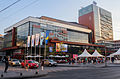
Clockwise from top: Sarajevo Canton government building; Koševo City Stadium; Skenderija; Sarajevo National Theatre; and the National Museum of Bosnia and Herzegovina | |
 Seal | |
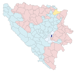 Location of Centar Municipality, Sarajevo within Bosnia and Herzegovina. | |
| Coordinates: 43°52′8″N 18°24′31″E / 43.86889°N 18.40861°E | |
| Country | |
| Entity | Federation of Bosnia and Herzegovina |
| Canton | |
| Government | |
| • Municipal mayor | Srđan Mandić (NS) |
| Area | |
| • Total | 33 km2 (13 sq mi) |
| Population (2013 census) | |
| • Total | 55,181 |
| • Density | 1,795/km2 (4,650/sq mi) |
| Time zone | UTC+1 (CET) |
| • Summer (DST) | UTC+2 (CEST) |
| Area code | +387 33 |
| Website | www |


The Centar municipality is the administrative, business, commercial, cultural, educational, and medical centre of Sarajevo. Although some of these may be disputed, Centar is certainly the most important part of Sarajevo, housing most major branches of the city and national governments.
The municipality of Centar occupies 3,313 hectrates of land, of which close to 17% is housing. The amount of private and state owned land is nearly equal, with 1600 and 1713 hectrates respectively. The municipality celebrates May 2 as "Centar Municipality Day", in commemoration of the heroic defense by citizens of the aggressor's assault on the Building of the Presidency of Bosnia and Herzegovina. Centar is also home to many Olympic complexes such as Mirza Delibašić Hall and sports venues Asim Ferhatović Hase Stadium and Zetra Olympic Hall.
History edit
The Siege of Sarajevo had a tremendous effect on Centar. Prior to the aggression, Centar municipality had 79,000 citizens, of which the majority were Bosniaks. 7,000 citizens of the municipality were killed by the aggressors during the war, as major battles took place on its grounds. There was also a heavy presence of land mines in the area, however in December 2003 the government succeeded in clearing all land mines from the area. Since the end of the war, the municipality has received 12 major awards, indicating its current well-being and prosperity.
Demographics edit
1971 edit
126,598 total
- Bosniaks - 74,354 (58.73%)
- Serbs - 27,658 (21.84%)
- Croats - 12,903 (10.19%)
- Yugoslavs - 5,944 (4.69%)
- Others - 5,739 (4.55%)
1991 edit
79,286 total
- Bosniaks - 39,761 (50.14%)
- Serbs - 16,631 (20.97%)
- Croats - 5,428 (6.84%)
- Yugoslavs - 13,030 (16.43%)
- Others - 4,436 (5.62%)
2013 edit
55,181 total[1]
- Bosniaks - 41,702 (75.57%)
- Croats - 3,333 (6.04%)
- Serbs - 2,186 (3.96%)
- Others - 7,960 (14.42%)
Communities and neighborhoods edit

- Bardakčije
- Betanija - Šip
- Breka - Koševo II
- Ciglane
- Donji Velešići
- Džidžikovac - Koševo I
- Hrastovi - Mrkovići
- Koševsko Brdo
- Marijin Dvor - Crni Vrh - Gorica
- Mejtaš - Bjelave
- MZ Park - Višnjik
- Pionirska Dolina – Nahorevo
- Skenderija - Podtekija
- Soukbunar
- Trg Oslobođenja
Gallery edit
-
 No. 1 on this map of the Sarajevo Canton.
 -

-

-
-
-


References edit
- ^ "Census of population, households and dwellings in Bosnia and Herzegovina, 2013: Final results" (PDF). Agency for Statistics of Bosnia and Herzegovina. June 2016. Archived from the original (PDF) on 24 December 2017. Retrieved 5 August 2016.
- Official results from the book: Ethnic composition of Bosnia-Herzegovina population, by municipalities and settlements, 1991. census, Zavod za statistiku Bosne i Hercegovine - Bilten no.234, Sarajevo 1991.
External links edit
- The official web site of Centar municipality Sarajevo