


Summary
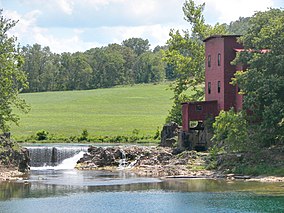
The Dillard Mill State Historic Site is a privately owned, state-administered property on Huzzah Creek in Crawford County, Missouri, that preserves a water-powered gristmill.[6] The 132-acre (53 ha) site has been operated as a state historic site by the Missouri Department of Natural Resources under a lease agreement with the L-A-D Foundation since 1975.[7] The site was listed on the National Register of Historic Places in 2015.[5]
| Dillard Mill State Historic Site | |
|---|---|
 | |
 Location in Missouri  Dillard Mill State Historic Site (the United States) | |
| Location | Crawford County, Missouri, United States |
| Coordinates | 37°43′03″N 91°12′24″W / 37.71750°N 91.20667°W[1] |
| Area | 131.77 acres (53.33 ha)[2] |
| Elevation | 906 ft (276 m)[1] |
| Established | 1977[3] |
| Visitors | 23,331 (in 2022)[4] |
| Governing body | Missouri Department of Natural Resources |
| Website | Dillard Mill State Historic Site |
Dillard Mill Historic District | |
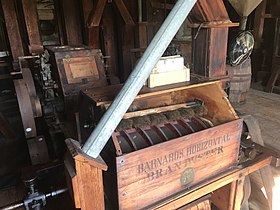 The mill's still working Barnard's Horizontal Bran Duster | |
| Location | 142 Dillard Mill Rd., near Davisville, Missouri |
| Area | 58 acres (23 ha) |
| Built by | Adams, Jacob; Mischke, Emil; Klemme, Lester |
| Architectural style | I-house, Bungalow |
| NRHP reference No. | 14001157 |
| Added to NRHP | January 14, 2015[5] |
History edit
A mill was built on Huzzah Creek in 1853 by Francis Wisdom and it was known as the Wisdom Mill. It was destroyed by fire in 1895. The property changed hands, and a new mill, the Mische Mill, was built in 1908. The Mische Mill used an underwater turbine rather than the old waterwheel, and the owners altered the course of the stream and the bluff at the site. The mill was in operation until 1956. It was renamed the Dillard Mill in 1975 when the state took over management of the property. It was dedicated as a historic site in 1977. Restoration of the mill was completed in 1980.[8][9]
See also edit
References edit
- ^ a b "Dillard Mill State Historic Site". Geographic Names Information System. United States Geological Survey, United States Department of the Interior.
- ^ "Dillard Mill State Historic Site: Data Sheet" (PDF). Missouri Department of Natural Resources. November 2017. Retrieved May 11, 2018.
- ^ "State Park Land Acquisition Summary". Missouri State Parks. Retrieved October 22, 2015.
- ^ "Missouri State Park Attendance For January - December, 2022" (PDF). Missouri State Parks. February 3, 2023.
- ^ a b "Weekly List of Actions Taken on Properties: 1/05/15 through 1/09/15". National Register of Historic Places Program: Weekly List. National Park Service. January 23, 2015. Retrieved November 27, 2016.
- ^ "Dillard Mill State Historic Site". Missouri Department of Natural Resources. Retrieved October 22, 2015.
- ^ "Dillard Mill State Historic Site: General Information". Missouri Department of Natural Resources. Retrieved May 11, 2018.
- ^ Suggs, George G., Wells, Jake K. (1990). Water Mills of the Missouri Ozarks. The University of Oklahoma Press. pp. 69–72. ISBN 0-8061-2432-6.
{{cite book}}: CS1 maint: multiple names: authors list (link) - ^ Bonnie Stepenoff (September 2014). "Dillard Mill Historic District" (PDF). National Register of Historic Places Inventory Nomination. Missouri Department of Natural Resources. Retrieved November 1, 2016. (includes 22 photos from 2014)
External links edit
- Dillard Mill State Historic Site Missouri Department of Natural Resources
- Dillard Mill State Historic Site Map Missouri Department of Natural Resources