
KNOWPIA
WELCOME TO KNOWPIA

Gisors 
Summary
Gisors (French pronunciation: [ʒizɔʁ]) is a commune of Normandy, France. It is located 62.9 km (39.1 mi) northwest from the centre of Paris.
Gisors | |
|---|---|
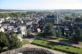 City as seen from the castle terrasse | |
 Coat of arms | |
Location of Gisors .mw-parser-output .locmap .od{position:absolute}.mw-parser-output .locmap .id{position:absolute;line-height:0}.mw-parser-output .locmap .l0{font-size:0;position:absolute}.mw-parser-output .locmap .pv{line-height:110%;position:absolute;text-align:center}.mw-parser-output .locmap .pl{line-height:110%;position:absolute;top:-0.75em;text-align:right}.mw-parser-output .locmap .pr{line-height:110%;position:absolute;top:-0.75em;text-align:left}.mw-parser-output .locmap .pv>div{display:inline;padding:1px}.mw-parser-output .locmap .pl>div{display:inline;padding:1px;float:right}.mw-parser-output .locmap .pr>div{display:inline;padding:1px;float:left}html.skin-theme-clientpref-night .mw-parser-output .od,html.skin-theme-clientpref-night .mw-parser-output .od .pv>div,html.skin-theme-clientpref-night .mw-parser-output .od .pl>div,html.skin-theme-clientpref-night .mw-parser-output .od .pr>div{background:#fff;color:#000}html.skin-theme-clientpref-night .mw-parser-output .locmap{filter:grayscale(0.6)}@media(prefers-color-scheme:dark){html.skin-theme-clientpref-os .mw-parser-output .locmap{filter:grayscale(0.6)}html.skin-theme-clientpref-os .mw-parser-output .od,html.skin-theme-clientpref-os .mw-parser-output .od .pv>div,html.skin-theme-clientpref-os .mw-parser-output .od .pl>div,html.skin-theme-clientpref-os .mw-parser-output .od .pr>div{background:white;color:#000}}  Gisors  Gisors | |
| Coordinates: 49°16′52″N 1°46′38″E / 49.2811°N 1.7772°E | |
| Country | France |
| Region | Normandy |
| Department | Eure |
| Arrondissement | Les Andelys |
| Canton | Gisors |
| Intercommunality | Vexin Normand |
| Government | |
| • Mayor (2022–2026) | José Cerqueira[1] |
| Area 1 | 16.67 km2 (6.44 sq mi) |
| Population (2021)[2] | 11,919 |
| • Density | 710/km2 (1,900/sq mi) |
| Time zone | UTC+01:00 (CET) |
| • Summer (DST) | UTC+02:00 (CEST) |
| INSEE/Postal code | 27284 /27140 |
| Elevation | 47–142 m (154–466 ft) (avg. 74 m or 243 ft) |
| 1 French Land Register data, which excludes lakes, ponds, glaciers > 1 km2 (0.386 sq mi or 247 acres) and river estuaries. | |
Gisors, together with the neighbouring communes of Trie-Château and Trie-la-Ville, form an urban area of 13,915 inhabitants (2018).[3] This urban area is a satellite town of Paris.
Geography edit
Gisors is located in the Vexin normand region of Normandy, at the confluence of the rivers Epte, Troesne and Réveillon.
Population edit
|
| ||||||||||||||||||||||||||||||||||||||||||||||||||||||||||||||||||||||||||||||||||||||||||||||||||||||||||||||||||
| Source: EHESS[4] and INSEE (1968–2017)[5] | |||||||||||||||||||||||||||||||||||||||||||||||||||||||||||||||||||||||||||||||||||||||||||||||||||||||||||||||||||
Transport edit
The Gisors station is the terminus of a Transilien suburban rail service from the Paris Saint-Lazare station, and of a TER Normandie local service to Serqueux.
Sights edit
- Château de Gisors, built in the 11th century.
- The Saint-Gervais-Saint-Protais parish church is an outstanding monument fusing Gothic and Renaissance architecture.
- A field near Gisors was the site of the Cutting of the elm, a medieval diplomatic incident.[6][7][8]
- Château de Boisgeloup, former home and atelier of Pablo Picasso.[9]
-
 Motte and Castle
 -
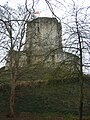 Castle of Gisors
 -
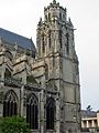 The so-called Grosse Tour ("Big Tower") of the St-Gervais-St-Protais church was built between 1542 and 1590.


See also edit
References edit
- ^ "Répertoire national des élus: les maires" (in French). data.gouv.fr, Plateforme ouverte des données publiques françaises. 6 June 2023.
- ^ "Populations légales 2021". The National Institute of Statistics and Economic Studies. 28 December 2023.
- ^ Comparateur de territoire, INSEE
- ^ Des villages de Cassini aux communes d'aujourd'hui: Commune data sheet Gisors, EHESS (in French).
- ^ Population en historique depuis 1968, INSEE
- ^ Bradford Smith, The Foundations of the West - Course Material, Chapter 8 The Age of the Crusades - The Rise of France under Philip Augustus and of St. Louis Archived 2008-06-12 at the Wayback Machine Oglethorpe University, Summer 2000.
- ^ Nicholas Vincent, "William Marshal, King Henry II and the Honour of Chateauroux Archived 2012-02-10 at the Wayback Machine", in: Archives: The Journal of the British Record Association vol. 25, no. 102 (2000).
- ^ A Thirteenth-Century Minstrel's Chronicle, a translation by Robert Levine of the Récits d'un ménestrel de Reims, a thirteenth-century historical fiction Archived 2008-05-16 at the Wayback Machine, Mellen Press, Lewiston, 1990.
- ^ Richardson, John (2012). Un Soir À Boisgeloup: L'Atelier De Pablo Picasso. Fundación Almine y Bernard Ruiz-Picasso para el Arte. ISBN 9782805201936.
External links edit
Wikimedia Commons has media related to Gisors.
- Official site
- Gazetteer Entry
- . Encyclopædia Britannica (11th ed.). 1911.