
KNOWPIA
WELCOME TO KNOWPIA

Grade II* listed buildings in Ashford (borough) 
Summary
There are over 20,000 Grade II* listed buildings in England. This page is a list of these buildings in the district of Ashford in Kent.
List of buildings edit
| Name | Location | Type | Completed [note 1] | Date designated | Grid ref.[note 2] Geo-coordinates |
Entry number [note 3] | Image |
|---|---|---|---|---|---|---|---|
| Cobb's Hall | Aldington | Continuous jetty house | c.1525–30 | 13 October 1952 | TR0666936276 51°05′19″N 0°56′59″E / 51.088552°N 0.949709°E |
1184555 |  |
| Court Lodge Farmhouse | Aldington | Farmhouse | 17th century | 27 November 1957 | TR0752036203 51°05′15″N 0°57′42″E / 51.087589°N 0.961801°E |
1071209 | 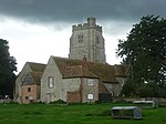 |
| Ruffyn's Hill Farmhouse and walls projecting | Aldington | House | 16th century or earlier | 13 October 1952 | TR0717036011 51°05′10″N 0°57′24″E / 51.085991°N 0.956701°E |
1184521 |  Upload Photo |
| Horne's Place | Appledore | Box frame house | 17th century | 4 June 1952 | TQ9574530870 51°02′38″N 0°47′28″E / 51.043827°N 0.791003°E |
1362879 |  More images
|
| Bridge House | Ashford | House | 18th century | 24 September 1951 | TR0144042774 51°08′56″N 0°52′44″E / 51.148767°N 0.878772°E |
1071079 |  More images
|
| Nightingale House | Ashford | House | 18th century | 24 September 1951 | TR0127342767 51°08′56″N 0°52′35″E / 51.148763°N 0.876383°E |
1071078 |  More images
|
| The College | Ashford | Vicarage | Edward IV | 24 September 1951 | TR0106142703 51°08′54″N 0°52′24″E / 51.148263°N 0.87332°E |
1184332 |  More images
|
| The Doctor Wilks Memorial Hall | Ashford | Grammar school | 1635 | 24 September 1951 | TR0098042760 51°08′56″N 0°52′20″E / 51.148803°N 0.872196°E |
1071118 |  More images
|
| Whist House | Ashford | House | 1707 | 24 September 1951 | TR0134542465 51°08′46″N 0°52′38″E / 51.146026°N 0.877243°E |
1299918 | Upload Photo |
| 22 North Street | Ashford | House | 18th century | 24 September 1951 | TR0106842917 51°09′01″N 0°52′25″E / 51.150182°N 0.87354°E |
1071037 |  More images
|
| 91 High Street | Ashford | House | 18th century | 24 September 1951 | TR0091042816 51°08′58″N 0°52′16″E / 51.149331°N 0.871227°E |
1184508 | Upload Photo |
| 51–55 High Street | Ashford | House | 18th century | 24 September 1951 | TR0105142770 51°08′56″N 0°52′24″E / 51.148868°N 0.873215°E |
1362831 |  More images
|
| Willesborough Windmill | Willesborough, Ashford | Windmill | 1868 | 24 September 1951 | TR0312942132 51°08′33″N 0°54′09″E / 51.142405°N 0.902526°E |
1184561 |  More images
|
| Pimphurst Farmhouse | Bethersden | Farmhouse | Circa early 16th century | 10 October 1980 | TQ9252942129 51°08′46″N 0°45′04″E / 51.146039°N 0.75118°E |
1070788 | Upload Photo |
| Ring Cottage | Wissenden, Bethersden | Timber-framed house | 15th century | 14 February 1967 | TQ9127541132 51°08′15″N 0°43′58″E / 51.137504°N 0.732745°E |
1362987 | Upload Photo |
| The Old House | Wissenden, Bethersden | Timber-framed house | 15th century | 14 February 1967 | TQ9068141448 51°08′26″N 0°43′28″E / 51.14054°N 0.724431°E |
1070764 |  More images
|
| Tuesnoad Cottage | Tuesnoad, Bethersden | Farmhouse | 16th century or earlier | 14 February 1967 | TQ9086242136 51°08′48″N 0°43′39″E / 51.146659°N 0.72738°E |
1362986 | Upload Photo |
| Biddenden Place | Biddenden | House | Dated 1624 | 4 June 1952 | TQ8515838301 51°06′51″N 0°38′38″E / 51.114084°N 0.643956°E |
1299500 |  More images
|
| Birchley Farmhouse | Biddenden | Farmhouse | 16th century | 16 August 1962 | TQ8452537196 51°06′16″N 0°38′04″E / 51.104362°N 0.634358°E |
1071005 |  More images
|
| Castwisell Manor Farmhouse | Biddenden | Farmhouse | 15th century | 4 June 1952 | TQ8348337466 51°06′26″N 0°37′11″E / 51.107122°N 0.619628°E |
1184788 | Upload Photo |
| Great Bachelors Hall | Biddenden | Timber-framed house | 15th century | 4 June 1952 | TQ8326638496 51°06′59″N 0°37′01″E / 51.116443°N 0.617054°E |
1070991 | Upload Photo |
| Hendon Hall | Biddenden | House | Late 17th century | 4 June 1952 | TQ8509238330 51°06′52″N 0°38′35″E / 51.114366°N 0.643029°E |
1070956 |  |
| Standen | Standen, Biddenden | Guesthouse | 15th century | 16 August 1962 | TQ8559140056 51°07′47″N 0°39′04″E / 51.129708°N 0.651037°E |
1185339 | Upload Photo |
| The Cott | Biddenden | House | c.1535 | 9 August 1979 | TQ8556139355 51°07′24″N 0°39′01″E / 51.123421°N 0.650248°E |
1071009 | Upload Photo |
| Vane Court | Biddenden | Wealden house | 15th century | 9 August 1979 | TQ8588740472 51°08′00″N 0°39′20″E / 51.133349°N 0.655477°E |
1362899 |  More images
|
| Barn about 50 metres south-west of Court Lodge | Bilsington | Aisled barn | 15th century | 10 August 1988 | TR0411534234 51°04′16″N 0°54′44″E / 51.071127°N 0.912138°E |
1300006 | Upload Photo |
| Church of St Peter and St Paul | Bilsington | Church | 12th century | 27 November 1957 | TR0421634264 51°04′17″N 0°54′49″E / 51.071361°N 0.913595°E |
1071191 |  More images
|
| Boughton Court | Boughton Aluph | Manor house | 16th century | 13 October 1952 | TR0328048209 51°11′49″N 0°54′29″E / 51.196926°N 0.908114°E |
1362711 | Upload Photo |
| The Hall | Brabourne | House | Early 18th century | 13 October 1952 | TR0884042546 51°08′39″N 0°59′03″E / 51.14407°N 0.984292°E |
1232797 | Upload Photo |
| Barn about 20 metres west | Brook | Barn | Mid-17th century | 27 November 1957 | TR0650342339 51°08′35″N 0°57′03″E / 51.143058°N 0.950811°E |
1232968 |  |
| Court Lodge | Brook | House | 15th century or earlier | 27 November 1957 | TR0663344231 51°09′36″N 0°57′14″E / 51.160001°N 0.953752°E |
1276825 | Upload Photo |
| Forstal Farmhouse | Brook | Farmhouse | 17th century | 27 November 1957 | TR0623644003 51°09′29″N 0°56′53″E / 51.158097°N 0.947952°E |
1232970 | Upload Photo |
| Troy Town House and Wall | Troy Town, Brook | House | Late 17th century | 15 March 1988 | TR0711244354 51°09′39″N 0°57′38″E / 51.160933°N 0.960663°E |
1232977 | Upload Photo |
| Church of St Cosmas and St Damian | Challock | Church | 1504 | 27 November 1957 | TR0114449196 51°12′24″N 0°52′41″E / 51.206545°N 0.878137°E |
1185088 |  More images
|
| Great Paddock Farmhouse | Challock | Manor house | Early 17th century | 27 November 1957 | TQ9916150244 51°13′00″N 0°51′01″E / 51.216651°N 0.850368°E |
1071302 | 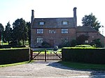 |
| Laurenden Forstal, Nine Chimneys | Challock Lees, Challock | Jettied house | 17th century | 13 August 1984 | TR0101250478 51°13′05″N 0°52′37″E / 51.218104°N 0.876967°E |
1362736 | Upload Photo |
| Brockton Manor | Charing Heath, Charing | House | 18th century | 14 February 1967 | TQ9242449006 51°12′28″N 0°45′12″E / 51.20784°N 0.75336°E |
1070774 | Upload Photo |
| Chapel at Newlands Stud Farm | Charing | Chapel | Late Norman | 17 September 1952 | TQ9362748211 51°12′01″N 0°46′12″E / 51.200294°N 0.770132°E |
1071538 |  |
| Ludwell House | Charing | House | Early 18th century | 17 September 1952 | TQ9529449471 51°12′40″N 0°47′41″E / 51.211043°N 0.794648°E |
1185767 |  |
| Newlands Stud Farmhouse | Charing | Farmhouse | Possibly late Norman | 10 October 1980 | TQ9368748185 51°12′00″N 0°46′16″E / 51.20004°N 0.770976°E |
1071537 | Upload Photo |
| Peirce House | Charing | House | 13th century | 17 September 1952 | TQ9527249423 51°12′38″N 0°47′40″E / 51.21062°N 0.794307°E |
1070742 |  More images
|
| Sherborne House | Charing | House | Mid-16th century | 17 September 1952 | TQ9527049387 51°12′37″N 0°47′39″E / 51.210297°N 0.794259°E |
1070740 |  |
| The Old House | Charing | House | 14th century | 17 September 1952 | TQ9519449236 51°12′32″N 0°47′35″E / 51.208967°N 0.79309°E |
1186103 |  |
| The Old Vicarage, Vicarage Cottage | Charing | Vicarage | c.1702 | 14 February 1967 | TQ9550149385 51°12′37″N 0°47′51″E / 51.2102°N 0.797561°E |
1185849 |  |
| Tithe Barn to the south-east of Pett Place | Charing | Tithe barn | Medieval, refaced 17th century | 14 February 1967 | TQ9614348921 51°12′21″N 0°48′23″E / 51.205813°N 0.806487°E |
1362628 | Upload Photo |
| Tram Hatch | Charing | House | 15th to 16th century | 10 October 1980 | TQ9234747474 51°11′39″N 0°45′05″E / 51.194106°N 0.751438°E |
1070770 | Upload Photo |
| Wakeley House | Charing | House | 18th century | 17 September 1952 | TQ9533649517 51°12′41″N 0°47′43″E / 51.211442°N 0.795273°E |
1070747 |  |
| Wickens Manor | Charing | House | 16th century | 17 September 1952 | TQ9602348331 51°12′02″N 0°48′16″E / 51.200555°N 0.804449°E |
1071548 | Upload Photo |
| The Vicarage | Chilham | Vicarage | 1746 | 13 October 1952 | TR0694253682 51°14′41″N 0°57′49″E / 51.244759°N 0.96361°E |
1071252 |  More images
|
| Hunt Street Farmhouse | Crundale | Farmhouse | c.1595 | 13 October 1952 | TR0906848592 51°11′54″N 0°59′28″E / 51.198278°N 0.99106°E |
1185666 | Upload Photo |
| Lake House | Eastwell | House | Late 13th century | 13 October 1952 | TR0101347326 51°11′23″N 0°52′31″E / 51.189797°N 0.875217°E |
1362760 |  More images
|
| Link House | Egerton | Timber-framed house | 15th century | 17 September 1952 | TQ8976847207 51°11′33″N 0°42′52″E / 51.19257°N 0.714432°E |
1071518 |  More images
|
| Court Lodge | Great Chart with Singleton | House | 13th century | 17 September 1952 | TQ9791441934 51°08′33″N 0°49′41″E / 51.142452°N 0.827963°E |
1362641 |  |
| Little Singleton | Great Chart with Singleton | Timber-framed house | 16th century or earlier | 14 February 1967 | TQ9706141678 51°08′26″N 0°48′56″E / 51.140447°N 0.815644°E |
1071474 | Upload Photo |
| Singleton Manor | Great Chart with Singleton | Manor house | 16th century or earlier | 17 September 1952 | TQ9888241647 51°08′22″N 0°50′30″E / 51.13954°N 0.841624°E |
1116272 | Upload Photo |
| Timber-framed building in the south-west corner of the churchyard of Church of St Mary (Pest House) | Great Chart with Singleton | Timber-framed house | 16th century or earlier | 14 February 1967 | TQ9796041884 51°08′31″N 0°49′43″E / 51.141987°N 0.828592°E |
1071488 |  More images
|
| Yardhurst | Daniel's Water, Great Chart with Singleton | Timber-framed house | 15th century | 17 September 1952 | TQ9557641172 51°08′11″N 0°47′39″E / 51.136411°N 0.794168°E |
1071478 | Upload Photo |
| South Hill and wall and steps attached | Hastingleigh | House | c.1640 | 27 November 1957 | TR0960743995 51°09′24″N 0°59′46″E / 51.156801°N 0.996085°E |
1276735 | Upload Photo |
| Potkiln Farmhouse | Further Quarter, High Halden | Farmhouse | c.1600 | 16 August 1962 | TQ8982439325 51°07′18″N 0°42′40″E / 51.121756°N 0.711078°E |
1362889 | Upload Photo |
| Swinford Manor School | Swinford, Hothfield | House | 19th century | 10 October 1980 | TQ9751543725 51°09′31″N 0°49′24″E / 51.158675°N 0.823248°E |
1115575 | Upload Photo |
| Church of St Mary | Kenardington | Church | 13th century | 16 August 1962 | TQ9747832132 51°03′16″N 0°48′59″E / 51.054569°N 0.81638°E |
1116484 |  More images
|
| Manor Farmhouse | Kenardington | Farmhouse | 16th century or earlier | 4 June 1952 | TQ9691732344 51°03′24″N 0°48′31″E / 51.056666°N 0.808501°E |
1116469 | Upload Photo |
| Calehill House | Calehill Park, Little Chart | House | Early 17th century | 14 February 1967 | TQ9416447142 51°11′26″N 0°46′38″E / 51.190511°N 0.777231°E |
1071434 | Upload Photo |
| Barn about 30 metres north-west of Mersham Manor | Mersham | Aisled barn | Early to mid-14th century | 16 February 1989 | TR0515839414 51°07′02″N 0°55′48″E / 51.117274°N 0.929946°E |
1233497 |  |
| Bower Farmhouse | Mersham | Farmhouse | 16th–18th century | 27 November 1957 | TR0565439388 51°07′01″N 0°56′13″E / 51.116863°N 0.937008°E |
1276692 | Upload Photo |
| Mill House, Swanton Mill | South Stour, Mersham | Mill house | 16th century | 27 November 1957 | TR0388438856 51°06′46″N 0°54′41″E / 51.112717°N 0.911453°E |
1276466 | Upload Photo |
| Newhouse | Mersham | House | 17th century | 13 October 1952 | TR0545039970 51°07′20″N 0°56′04″E / 51.122162°N 0.934428°E |
1276324 | Upload Photo |
| Stonegreen Hall | Mersham | House | 1704 | 13 October 1952 | TR0469938350 51°06′28″N 0°55′22″E / 51.107883°N 0.922793°E |
1233498 | Upload Photo |
| Stonelees | Mersham | Continuous jetty house | 16th century | 27 November 1957 | TR0450837281 51°05′54″N 0°55′10″E / 51.098351°N 0.919463°E |
1233761 |  |
| Great Bower Farmhouse | Molash | Farmhouse | 16th century | 27 November 1957 | TR0340852939 51°14′22″N 0°54′45″E / 51.239357°N 0.912625°E |
1071242 |  More images
|
| Parish Church of St Peter | Newenden | Church | 14th or 15th century | 16 August 1962 | TQ8343327306 51°00′57″N 0°36′50″E / 51.015873°N 0.613767°E |
1116453 |  More images
|
| Church of St Mary the Virgin | Orlestone | Church | Late 12th/early 13th century | 27 November 1957 | TR0001034696 51°04′36″N 0°51′14″E / 51.076721°N 0.853878°E |
1184978 |  More images
|
| Court Lodge | Orlestone | House | 16th century | 13 October 1952 | TQ9998434641 51°04′34″N 0°51′13″E / 51.076236°N 0.853477°E |
1184992 |  |
| Cooper Farmhouse | Pluckley | Farmhouse | 15th century | 14 February 1967 | TQ9151743948 51°09′46″N 0°44′16″E / 51.162716°N 0.737697°E |
1145835 | 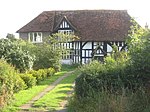 More images
|
| Dowle Street Cottages | Pluckley | Farmhouse | 15th century | 14 February 1967 | TQ9357243757 51°09′37″N 0°46′01″E / 51.160309°N 0.766948°E |
1318895 | Upload Photo |
| Gore Court | Pluckley | Wealden house | 15th century | 14 February 1967 | TQ9336644028 51°09′46″N 0°45′51″E / 51.162813°N 0.764151°E |
1087078 |  |
| Granary and oasthouse to the south-west of Sheerland Farmhouse | Pluckley | Oasthouse | 1838 | 14 February 1967 | TQ9335045456 51°10′32″N 0°45′53″E / 51.175644°N 0.76469°E |
1335838 |  |
| Gatehouse to Great Maytham | Rolvenden | Gatehouse | Designed 1909–12 | 4 June 1952 | TQ8489530730 51°02′46″N 0°38′11″E / 51.046162°N 0.636332°E |
1070886 | 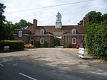 More images
|
| Great Maytham | Rolvenden | House | 1721 | 4 June 1952 | TQ8481930620 51°02′43″N 0°38′07″E / 51.045198°N 0.635193°E |
1115477 |  More images
|
| Kingpost | Rolvenden | House | 18th century | 4 June 1952 | TQ8443531581 51°03′14″N 0°37′49″E / 51.053954°N 0.63021°E |
1115555 |  |
| Rawlinson Farmhouse | Hole Park, Rolvenden | Farmhouse | 15th century | 4 June 1952 | TQ8390932650 51°03′49″N 0°37′24″E / 51.063725°N 0.623257°E |
1362909 | Upload Photo |
| Rolvenden Windmill | Rolvenden | Windmill | Site of mill of 1596 | 16 August 1962 | TQ8381531537 51°03′14″N 0°37′17″E / 51.053757°N 0.621352°E |
1116206 |  More images
|
| 2, 4 and 6 Hastings Road | Rolvenden | House | 18th century | 16 August 1962 | TQ8447231258 51°03′04″N 0°37′50″E / 51.05104°N 0.630573°E |
1070913 |  |
| Church of St Peter and St Paul | Shadoxhurst | Church | 13th century | 14 February 1967 | TQ9723737601 51°06′14″N 0°48′57″E / 51.10377°N 0.815928°E |
1326649 |  More images
|
| Biddenden Green Farmhouse | Smarden | Farmhouse | 15th century | 14 February 1967 | TQ8878142867 51°09′14″N 0°41′53″E / 51.153915°N 0.698047°E |
1362699 |  More images
|
| Chessenden | Smarden | Timber-framed house | 15th century | 17 September 1952 | TQ8827042405 51°09′00″N 0°41′26″E / 51.149933°N 0.690507°E |
1359673 |  More images
|
| Dragon Cottage | Smarden | Timber-framed house | 15th century | 17 September 1952 | TQ8809642333 51°08′58″N 0°41′17″E / 51.149344°N 0.687984°E |
1071360 |  |
| Hamden Grange | Smarden | House | 14th century | 17 September 1952 | TQ8914340715 51°08′04″N 0°42′08″E / 51.134466°N 0.702087°E |
1071368 | Upload Photo |
| Hartnup House | Smarden | House | 1671 | 17 September 1952 | TQ8792342335 51°08′58″N 0°41′08″E / 51.149418°N 0.685515°E |
1366291 |  More images
|
| The Cloth Hall | Smarden | Farmhouse | 16th century | 17 September 1952 | TQ8788742357 51°08′59″N 0°41′06″E / 51.149628°N 0.685012°E |
1071366 |  More images
|
| Bridge House/The Thatched House | Smarden | Hall house | 15th century | 14 February 1967 | TQ8782242092 51°08′50″N 0°41′02″E / 51.147269°N 0.683946°E |
1106331 | 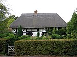 More images
|
| West Hoy Farmhouse | Smarden | Farmhouse | 15th century | 14 February 1967 | TQ8608542329 51°09′00″N 0°39′33″E / 51.149965°N 0.659263°E |
1071352 |  |
| Evegate Manor | Smeeth | House | Early 17th century | 27 November 1957 | TR0682238975 51°06′46″N 0°57′12″E / 51.112734°N 0.953436°E |
1362798 | Upload Photo |
| Lodge House | Smeeth | House | Early 18th century | 10 August 1988 | TR0852039673 51°07′06″N 0°58′41″E / 51.118387°N 0.978063°E |
1185326 | 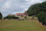 |
| Parish Church of St Mary the Virgin | Stone-cum-Ebony | Church | 15th century; contains Roman altar | 16 August 1962 | TQ9401927347 51°00′46″N 0°45′52″E / 51.01277°N 0.764527°E |
1362959 |  More images
|
| Ashenden | Tenterden | House | 17th century | 8 May 1950 | TQ8945331428 51°03′03″N 0°42′06″E / 51.050947°N 0.701645°E |
1362789 |  |
| Chestnut House | Tenterden | House | 18th century | 8 May 1950 | TQ8797832965 51°03′55″N 0°40′53″E / 51.065237°N 0.681423°E |
1203483 | Upload Photo |
| Church of St John the Baptist | Smallhythe, Tenterden | Church | Rebuilt 1516–17 | 8 May 1950 | TQ8935530162 51°02′23″N 0°41′59″E / 51.039608°N 0.699587°E |
1362790 |  More images
|
| East Hill House | Tenterden | House | 18th century | 8 May 1950 | TQ8884433657 51°04′16″N 0°41′39″E / 51.071169°N 0.694129°E |
1031824 | Upload Photo |
| Finchden Manor | Tenterden | House | 1658 (dated feature) | 8 May 1950 | TQ9007933127 51°03′58″N 0°42′41″E / 51.066001°N 0.711458°E |
1363181 | Upload Photo |
| Garden turrets in grounds of Hales Place | Tenterden | Tower | Early 16th century | 8 May 1950 | TQ8886133489 51°04′11″N 0°41′39″E / 51.069654°N 0.694284°E |
1362822 | Upload Photo |
| Hales Place | Tenterden | House | Early 16th century | 8 May 1950 | TQ8884733400 51°04′08″N 0°41′39″E / 51.068859°N 0.694038°E |
1071143 | Upload Photo |
| Maynard's Farmhouse | Tenterden | Farmhouse | Late 14th century | 8 June 1972 | TQ9015833068 51°03′56″N 0°42′45″E / 51.065445°N 0.712553°E |
1070383 |  More images
|
| Old Knockwood | Tenterden | Jettied house | 16th century | 8 May 1950 | TQ8972634276 51°04′35″N 0°42′25″E / 51.076438°N 0.707028°E |
1071130 | Upload Photo |
| Pigeon Hoo | Tenterden | Farmhouse | Early 15th century | 8 May 1950 | TQ9084933576 51°04′11″N 0°43′22″E / 51.069779°N 0.722671°E |
1071151 |  |
| Priest's House | Small Hythe, Tenterden | Jettied house | 15th century | 8 May 1950 | TQ8934230146 51°02′22″N 0°41′58″E / 51.039469°N 0.699393°E |
1281677 |  More images
|
| Smallhythe Place | Small Hythe, Tenterden | Jettied house | 15th century | 8 May 1950 | TQ8934229997 51°02′17″N 0°41′58″E / 51.03813°N 0.699316°E |
1071163 |  More images
|
| The Cedars | Tenterden | House | 18th century | 8 May 1950 | TQ8805632911 51°03′53″N 0°40′57″E / 51.064727°N 0.682507°E |
1071121 | Upload Photo |
| The White House | Tenterden | House | 18th century | 8 May 1950 | TQ8859433695 51°04′18″N 0°41′26″E / 51.071592°N 0.690584°E |
1070394 | Upload Photo |
| Westfield House | Tenterden | Apartment | Early 18th century | 8 May 1950 | TQ8791033109 51°04′00″N 0°40′50″E / 51.066553°N 0.680528°E |
1071128 | Upload Photo |
| Westwell | Tenterden | Country house | 1711 | 8 May 1950 | TQ8771033064 51°03′58″N 0°40′40″E / 51.066214°N 0.677654°E |
1071156 | Upload Photo |
| 29, 31 and 33 High Street | Tenterden | Jettied house | 16th century | 8 May 1950 | TQ8842333329 51°04′06″N 0°41′17″E / 51.068361°N 0.687956°E |
1025841 |  More images
|
| 15 and 17 East Cross | Tenterden | House | 18th century | 8 May 1950 | TQ8855433542 51°04′13″N 0°41′24″E / 51.070231°N 0.689934°E |
1070364 |  |
| Leacon Hall | Warehorne | House | 1708 | 10 August 1988 | TQ9866333087 51°03′46″N 0°50′02″E / 51.062738°N 0.833791°E |
1185579 | 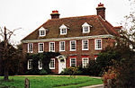 More images
|
| Digges Court | Westwell | Hall house | 16th century and later | 10 October 1980 | TQ9732447780 51°11′43″N 0°49′22″E / 51.195159°N 0.822745°E |
1071333 |  |
| The Stocks Windmill | Wittersham | Windmill | Dated 1781 | 4 June 1952 | TQ9130427305 51°00′48″N 0°43′33″E / 51.013301°N 0.725848°E |
1323124 | 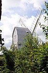 More images
|
| Diamond House | Woodchurch | House | Late 16th century to early 17th century | 9 August 1979 | TQ9249633692 51°04′13″N 0°44′46″E / 51.070271°N 0.746212°E |
1362980 |  |
| Hendon Place | The Green, Woodchurch | Clothiers house | 15th century | 4 June 1952 | TQ9437334911 51°04′50″N 0°46′25″E / 51.080587°N 0.773624°E |
1121861 |  More images
|
| Robhurst | Woodchurch | Wealden house | 16th century or earlier | 16 August 1962 | TQ9182534657 51°04′45″N 0°44′14″E / 51.079163°N 0.737157°E |
1337002 | Upload Photo |
| Shirley Farmhouse | Woodchurch | Farmhouse | 16th century or earlier | 9 August 1979 | TQ9318332532 51°03′35″N 0°45′19″E / 51.059622°N 0.755386°E |
1123740 | Upload Photo |
| Woodchurch Windmill | Woodchurch | Windmill | Early 18th century | 16 August 1962 | TQ9430335215 51°05′00″N 0°46′22″E / 51.083342°N 0.77279°E |
1121143 | 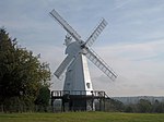 More images
|
| Old Swan House | Wye with Hinxhill | Continuous jetty house | 15th century | 27 November 1957 | TR0526446706 51°10′58″N 0°56′08″E / 51.18272°N 0.935613°E |
1365318 | Upload Photo |
| Spring Grove and walled garden attached | Wye with Hinxhill | House | 1674 | 13 October 1952 | TR0425046687 51°10′58″N 0°55′16″E / 51.182912°N 0.921114°E |
1216831 | Upload Photo |
| The Old Flying Horse Inn | Wye with Hinxhill | House | 16th century | 27 November 1957 | TR0548046804 51°11′01″N 0°56′20″E / 51.183522°N 0.938755°E |
1216805 |  More images
|
| The Old Manor House | Wye with Hinxhill | House | Late 16th century | 27 November 1957 | TR0541346815 51°11′01″N 0°56′16″E / 51.183645°N 0.937804°E |
1216736 | Upload Photo |
| The Wheel House (Junior Common Room), walls and gates attached | Wye with Hinxhill | House | 15th century | 27 November 1957 | TR0549246833 51°11′02″N 0°56′20″E / 51.183778°N 0.938943°E |
1275530 |  More images
|
| Wye Bridge | Wye with Hinxhill | Bridge | 1638 | 13 October 1952 | TR0486446920 51°11′05″N 0°55′48″E / 51.184785°N 0.930019°E |
1234208 |  More images
|
| Yew Trees | Wye with Hinxhill | Continuous jetty house | c.1600 | 13 October 1952 | TR0570946760 51°10′59″N 0°56′31″E / 51.183045°N 0.942002°E |
1217546 |  More images
|
See also edit
Notes edit
- ^ The date given is the date used by Historic England as significant for the initial building or that of an important part in the structure's description.
- ^ Sometimes known as OSGB36, the grid reference is based on the British national grid reference system used by the Ordnance Survey.
- ^ The "List Entry Number" is a unique number assigned to each listed building and scheduled monument by Historic England.