
KNOWPIA
WELCOME TO KNOWPIA

Grade I listed buildings in Merseyside 
Summary
There are over 9,000 Grade I listed buildings in England. This page is a list of these buildings in the county of Merseyside.

Knowsley edit
| Name | Location | Type | Completed [note 1] | Date designated | Grid ref.[note 2] Geo-coordinates |
Entry number [note 3] | Image |
|---|---|---|---|---|---|---|---|
| Church of St Mary | Prescot | Church | 14th century | 19 March 1951 | SJ4653192704 53°25′42″N 2°48′22″W / 53.4284°N 2.80617°W |
1199139 |  More images
|
Liverpool edit
| Name | Location | Type | Completed [note 1] | Date designated | Grid ref.[note 2] Geo-coordinates |
Entry number [note 3] | Image |
|---|---|---|---|---|---|---|---|
| Albert Dock Traffic Office | Albert Dock | Office | 1846–47 | 28 June 1952 | SJ3413789864 53°24′05″N 2°59′31″W / 53.401471°N 2.992077°W |
1356264 |  More images
|
| All Saints' Church | Childwall | Church | 14th century | 28 June 1952 | SJ4147689079 53°23′43″N 2°52′54″W / 53.395282°N 2.881564°W |
1356299 |  More images
|
| Anglican Cathedral Church of Christ | Liverpool | Anglican Cathedral | 1904 | 28 June 1952 | SJ3538289397 53°23′51″N 2°58′24″W / 53.397428°N 2.973258°W |
1361681 |  More images
|
| Bank of England Building | Liverpool | Bank (financial) | 1845–48 | 28 June 1952 | SJ3426290392 53°24′22″N 2°59′25″W / 53.406232°N 2.990307°W |
1205904 |  More images
|
| Bluecoat Chambers | Liverpool | Office | 1717 | 28 June 1952 | SJ3468590149 53°24′15″N 2°59′02″W / 53.404101°N 2.983895°W |
1292322 |  More images
|
| Church of All Hallows | Allerton | Church | 1872–76 | 28 June 1952 | SJ3998487473 53°22′50″N 2°54′13″W / 53.380681°N 2.903692°W |
1068414 | 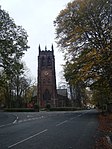 More images
|
| Church of St. Agnes and St. Pancras | Toxteth | Church | 1883–85 | 14 March 1975 | SJ3759188494 53°23′22″N 2°56′24″W / 53.389579°N 2.939863°W |
1359871 |  More images
|
| Church of St Clare | Liverpool | Church | 1888–90 | 28 June 1952 | SJ3779688649 53°23′28″N 2°56′13″W / 53.390996°N 2.936812°W |
1205333 |  More images
|
| Church of St George | Liverpool | Church | 1812–14 | 12 July 1966 | SJ3554492489 53°25′31″N 2°58′17″W / 53.425237°N 2.971456°W |
1075216 |  More images
|
| Church of St John the Baptist | Liverpool | Church | 1868–70 | 28 June 1952 | SJ3829792406 53°25′29″N 2°55′48″W / 53.424821°N 2.930016°W |
1063778 |  More images
|
| The Oratory | Liverpool | Hall | 1829 | 28 June 1952 | SJ3538689543 53°23′55″N 2°58′24″W / 53.398741°N 2.973228°W |
1063282 |  More images
|
| Oriel Chambers | Liverpool | Office | 1864 | 12 July 1966 | SJ3406790429 53°24′24″N 2°59′36″W / 53.40654°N 2.993248°W |
1291943 |  More images
|
| Philharmonic Hotel | Liverpool | Public House | 1898 | 12 July 1966 | SJ3556989883 53°24′07″N 2°58′14″W / 53.401819°N 2.970546°W |
1207638 |  More images
|
| Princes Road Synagogue | Liverpool | Synagogue | Built 1872–74 | 14 March 1975 | SJ3592689133 53°23′42″N 2°57′54″W / 53.395122°N 2.965025°W |
1072969 |  More images
|
| Railings, gates and gate piers Old Bluecoat School | Liverpool | Gate | c. 1717 | 14 March 1975 | SJ3469090180 53°24′16″N 2°59′02″W / 53.40438°N 2.983826°W |
1073446 | 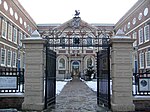 More images
|
| Royal Liver Building, iron railings and stone piers surrounding Royal Liver Building | George's Pier Head | Office | 1908–10 | 12 July 1966 | SJ3388090329 53°24′20″N 2°59′46″W / 53.405618°N 2.996039°W |
1356370 |  More images
|
| Speke Hall | Liverpool | House | 1540–60 | 28 June 1952 | SJ4186582568 53°20′13″N 2°52′28″W / 53.336807°N 2.874515°W |
1359837 | 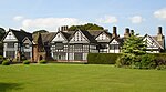 More images
|
| St George's Hall | Liverpool | Concert Hall | 1841–45 | 28 June 1952 | SJ3493190656 53°24′31″N 2°58′49″W / 53.408688°N 2.9803°W |
1361677 |  More images
|
| St Michael's Church | Aigburth | Church | 1814 | 28 June 1952 | SJ3690887058 53°22′36″N 2°56′59″W / 53.376592°N 2.949844°W |
1209945 |  More images
|
| Town Hall | Liverpool | Town Hall | 1749–54 | 28 June 1952 | SJ3417590496 53°24′26″N 2°59′30″W / 53.407156°N 2.991637°W |
1360219 |  More images
|
| Toxteth Unitarian Chapel | Liverpool | Chapel | Post 1618 | 28 June 1952 | SJ3637787590 53°22′53″N 2°57′29″W / 53.381309°N 2.957932°W |
1072991 |  More images
|
| Unitarian Chapel | Liverpool | Chapel | 1898 | 14 March 1975 | SJ3771388521 53°23′23″N 2°56′17″W / 53.389836°N 2.938034°W |
1218227 |  More images
|
| Unitarian Church Hall | Liverpool | Church Hall | 1901 | 14 March 1975 | SJ3773988504 53°23′23″N 2°56′16″W / 53.389686°N 2.93764°W |
1359872 | 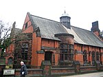 More images
|
| Warehouse A | Albert Dock | Warehouse | 1841–45 | 28 June 1952 | SJ3419789710 53°24′00″N 2°59′28″W / 53.400095°N 2.991142°W |
1205175 |  More images
|
| Warehouses B and C | Albert Dock | Warehouses | 1841–45 | 28 June 1952 | SJ3405689591 53°23′56″N 2°59′36″W / 53.399008°N 2.993237°W |
1068409 | 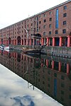 More images
|
| Warehouse D | Albert Dock | Warehouse (now Museum) | 1841–45 | 28 June 1952 | SJ3407989840 53°24′04″N 2°59′35″W / 53.401248°N 2.992944°W |
1280847 |  More images
|
| Warehouse E | Albert Dock | Apartment | 1985 | 28 June 1952 | SJ3415389833 53°24′04″N 2°59′31″W / 53.401195°N 2.991829°W |
1068410 |  More images
|
| Woolton Hall | Liverpool | House | 1704 | 28 June 1982 | SJ4254886416 53°22′17″N 2°51′54″W / 53.371466°N 2.864959°W |
1217943 |  More images
|
Sefton edit
| Name | Location | Type | Completed [note 1] | Date designated | Grid ref.[note 2] Geo-coordinates |
Entry number [note 3] | Image |
|---|---|---|---|---|---|---|---|
| Church of St Helen | Sefton | Church | Early 14th century | 11 October 1968 | SD3568301295 53°30′16″N 2°58′16″W / 53.504395°N 2.971169°W |
1075852 | 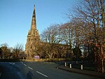 More images
|
| Church of St Monica | Bootle | Church | 1936 | 19 March 1981 | SJ3503495685 53°27′14″N 2°58′47″W / 53.453897°N 2.9797901°W |
1283647 |  More images
|
St. Helens edit
| Name | Location | Type | Completed [note 1] | Date designated | Grid ref.[note 2] Geo-coordinates |
Entry number [note 3] | Image |
|---|---|---|---|---|---|---|---|
| Sankey Viaduct over Sankey Brook (that part in St Helens District) | St Helens | Railway Viaduct | 1830 | 3 February 1966 | SJ5688294719 53°26′51″N 2°39′02″W / 53.44746°N 2.650677°W |
1075927 |  More images
|
Wirral edit
| Name | Location | Type | Completed [note 1] | Date designated | Grid ref.[note 2] Geo-coordinates |
Entry number [note 3] | Image |
|---|---|---|---|---|---|---|---|
| Brimstage Hall and Tower | Brimstage | House | c. 1398 | 27 December 1962 | SJ3042482699 53°20′12″N 3°02′47″W / 53.336602°N 3.046332°W |
1183702 |  More images
|
| Church of St. Andrew | Lower Bebington | Church | 12th century | 27 December 1962 | SJ3330183908 53°20′52″N 3°00′12″W / 53.347838°N 3.003389°W |
1075462 |  More images
|
| Numbers 1 to 18 (consecutive), Hamilton Square including railings to front | Birkenhead | Model Dwelling | c. 1825 | 29 July 1950 | SJ3258789088 53°23′39″N 3°00′55″W / 53.394301°N 3.015219°W |
1201580 |  More images
|
| Numbers 19 to 34 (consecutive), Hamilton Square - with railings to front | Birkenhead | Model Dwelling | 1839–44 | 29 July 1950 | SJ3245089045 53°23′38″N 3°01′02″W / 53.393897°N 3.01727°W |
1292180 | 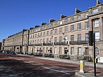 More images
|
| Numbers 35 to 51 (consecutive), Hamilton Square - with railings to front | Birkenhead | Model Dwelling | 1839–44 | 29 July 1950 | SJ3250088927 53°23′34″N 3°00′59″W / 53.392843°N 3.016493°W |
1292148 |  More images
|
| Numbers 52 to 57 (consecutive), Hamilton Square - with railings to front | Birkenhead | Model Dwelling | c. 1844 | 29 July 1950 | SJ3260488927 53°23′34″N 3°00′54″W / 53.392856°N 3.014929°W |
1282616 |  More images
|
| Numbers 58 to 63 (consecutive), Hamilton Square - with railings to front, flanking wall and gate piers to north-east | Birkenhead | Model Dwelling | c. 1825 | 29 July 1950 | SJ3268189036 53°23′38″N 3°00′50″W / 53.393846°N 3.013795°W |
1218048 | 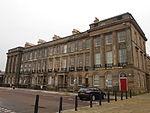 More images
|
| Remains of Birkenhead Priory | Birkenhead | Church | 1150–1400 | 29 July 1950 | SJ3280788542 53°23′22″N 3°00′42″W / 53.389422°N 3.011795°W |
1201757 |  More images
|
| Port Sunlight War Memorial | Port Sunlight | War memorial | 1919–21 | 28 October 2014 | SJ3367484480 53°21′11″N 2°59′52″W / 53.35303°N 2.99791°W |
1343491 |  More images
|
See also edit
Notes edit
- ^ a b c d e The date given is the date used by Historic England as significant for the initial building or that of an important part in the structure's description.
- ^ a b c d e Sometimes known as OSGB36, the grid reference is based on the British national grid reference system used by the Ordnance Survey.
- ^ a b c d e The "List Entry Number" is a unique number assigned to each listed building and scheduled monument by Historic England.
References edit
National Heritage List for England
External links edit
![]() Media related to Grade I listed buildings in Merseyside at Wikimedia Commons
Media related to Grade I listed buildings in Merseyside at Wikimedia Commons