


Summary
There are 62 Grade I listed buildings in South Yorkshire, England. In the United Kingdom, the term listed building refers to a building or other structure officially designated as being of special architectural, historical or cultural significance; Grade I structures are those considered to be "buildings of exceptional interest".[1] In England, the authority for listing under the Planning (Listed Buildings and Conservation Areas) Act 1990[2] rests with Historic England, a non-departmental public body sponsored by the Department for Culture, Media and Sport.

Listing by metropolitan boroughs edit
The metropolitan county of South Yorkshire is made up of four metropolitan boroughs: Barnsley, Doncaster, Rotherham and Sheffield. The Grade I listed buildings in each borough are shown separately.
Barnsley edit
| Name | Location | Type | Architect | Completed [note 1] | Date designated | Grid ref.[note 2] Geo-coordinates |
Entry number [note 3] | Image | Ref. |
|---|---|---|---|---|---|---|---|---|---|
| Gunthwaite Hall Barn | Gunthwaite Lane, Gunthwaite | Barn | c. 1800 | 25 February 1952 | SE2378506567 53°33′19″N 1°38′33″W / 53.555195°N 1.642442°W |
1151106 |  More images |
[3] | |
| Wortley Top Forge | Cote Lane, Hunshelf | Bloomery | Early 17th century | 18 March 1968 | SK2944699872 53°29′41″N 1°33′27″W / 53.494734°N 1.557621°W |
1315032 |  More images |
[4] | |
| St John the Baptist, Penistone | Market Place, Penistone | Church | 15th century | 23 June 1965 | SE2465103316 53°31′33″N 1°37′47″W / 53.525934°N 1.629626°W |
1314709 | 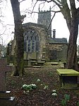 More images |
[5] | |
| All Saints, Silkstone | High Street, Silkstone | Church | 15th century | 18 March 1968 | SE2908605844 53°32′54″N 1°33′45″W / 53.548431°N 1.562494°W |
1151740 |  More images |
[6] | |
| Wentworth Castle | Wentworth Castle, Stainborough | House | William Wentworth and Charles Ross | c. 1760 | 25 February 1952 | SE3199703182 53°31′28″N 1°31′08″W / 53.524336°N 1.518833°W |
1151065 | 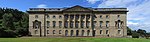 More images |
[7] |
| Administration building at Monk Bretton Priory | Abbey Lane, Barnsley | Guest House | 1281–1538 | 6 February 1952 | SE3730106592 53°33′17″N 1°26′18″W / 53.554636°N 1.438427°W |
1151179 |  More images |
[8] | |
| All Saints, Darton | Church Street, Darton | Church | Thomas de Tykyll | 16th century | 13 November 1963 | SE3111009915 53°35′06″N 1°31′54″W / 53.584905°N 1.531545°W |
1286515 |  More images |
[9] |
| All Saints, Darfield | Church Street, Darfield | Church | 15th century | 14 October 1964 | SE4188004306 53°32′01″N 1°22′11″W / 53.533746°N 1.369619°W |
1315015 |  More images |
[10] | |
| St Andrew the Apostle, Bolton upon Dearne | High Street, Bolton upon Dearne | Church | 14th century | 23 August 1963 | SE4558502526 53°31′03″N 1°18′50″W / 53.51744°N 1.313984°W |
1191492 |  More images |
[11] | |
| St John the Baptist, Royston | Church Street, Royston | Church | 15th century | 13 October 1986 | SE3642311243 53°35′47″N 1°27′04″W / 53.5965°N 1.451139°W |
1151127 |  More images |
[12] | |
| St Mary, Worsborough | Worsborough | Church | 15th century | 11 November 1966 | SE3496702622 53°31′09″N 1°28′27″W / 53.519114°N 1.474099°W |
1315083 | 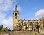 More images |
[13] | |
| Gatehouse to Monk Bretton Priory | Abbey Lane, Barnsley | Porters Lodge | Late 16th century | 6 February 1952 | SE3726106600 53°33′17″N 1°26′21″W / 53.554711°N 1.43903°W |
1315023 | 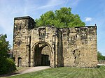 More images |
[14] | |
| Monk Bretton Priory Remains | Abbey Lane, Barnsley | Priory | 15th century | 6 February 1952 | SE3732706463 53°33′13″N 1°26′17″W / 53.553475°N 1.43805°W |
1151178 |  More images |
[15] |
Doncaster edit
| Name | Location | Type | Architect | Completed [note 1] | Date designated | Grid ref.[note 2] Geo-coordinates |
Entry number [note 3] | Image | Ref. |
|---|---|---|---|---|---|---|---|---|---|
| St Peter, Barnburgh | Barnburgh, Doncaster | Church | 15th century | 5 June 1968 | SE4841303211 53°31′24″N 1°16′16″W / 53.523344°N 1.271231°W |
1151675 |  More images |
[16] | |
| St Peter and St Paul, Barnby Dun | Church Road, Barnby Dun | Church | 15th century | 5 June 1968 | SE6141909730 53°34′50″N 1°04′26″W / 53.580575°N 1.073802°W |
1151488 | 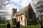 More images |
[17] | |
| Church of St Nicholas, Bawtry | Church Road, Bawtry | Church | 15th century | 5 June 1968 | SK6532592992 53°25′47″N 1°01′06″W / 53.429679°N 1.018296°W |
1314824 | 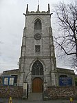 More images |
[18] | |
| Brodsworth Hall | Brodsworth | Country House | Chevalier Casentini and Philip Wilkinson | 1861–1863 | 5 June 1968 | SE5059507044 53°33′27″N 1°14′16″W / 53.557588°N 1.237704°W |
1191614 |  More images |
[19] |
| St Helen, Burghwallis | Grange Lane, Burghwallis | Church | 12th century | 5 June 1968 | SE5369712026 53°36′07″N 1°11′24″W / 53.602056°N 1.190027°W |
1151457 |  More images |
[20] | |
| St Peter, Edlington | Edlington Lane, Edlington | Church | 15th century | 5 June 1968 | SK5324997253 53°28′10″N 1°11′57″W / 53.46933°N 1.199304°W |
1286332 |  More images |
[21] | |
| Holy Trinity and St Oswald, Finningley | Rectory Lane, Finningley | Church | 15th century | 11 January 1988 | SK6695399138 53°29′05″N 0°59′33″W / 53.484709°N 0.992492°W |
1286821 |  More images |
[22] | |
| St Cuthbert, Fishlake | Church Lane, Fishlake | Church | 15th century | 24 November 1966 | SE6563113176 53°36′40″N 1°00′34″W / 53.611035°N 1.00947°W |
1314801 | 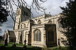 More images |
[23] | |
| St Lawrence, Hatfield | Station Road, Hatfield | Church | Edwin Dolby | 12th century | 24 November 1966 | SE6630109586 53°34′43″N 1°00′00″W / 53.578688°N 1.000107°W |
1192628 |  More images |
[24] |
| Hatfield Manor House | Manor Road, Hatfield | Hall House | 12th century | 13 December 1951 | SE6631309331 53°34′35″N 1°00′00″W / 53.576395°N 0.99998°W |
1151589 |  Upload Photo |
[25] | |
| St Wilfrid, Hickleton | Hickleton | Church | 16th century | 5 June 1968 | SE4830005301 53°32′32″N 1°16′21″W / 53.542139°N 1.272614°W |
1314784 |  More images |
[26] | |
| All Saints, Hooton Pagnell | Hooton Pagnell, Doncaster | Church | 14th century | 5 June 1968 | SE4854207951 53°33′57″N 1°16′07″W / 53.565934°N 1.268552°W |
1314808 |  More images |
[27] | |
| St Helen, Marr | Church Lane, Marr | Church | 14th century | 5 June 1968 | SE5145405338 53°32′32″N 1°13′30″W / 53.542172°N 1.225018°W |
1192644 |  More images |
[28] | |
| St Mary Magdalene, Norton | High Street, Campsall | Church | 15th century | 5 June 1968 | SE5447614076 53°37′13″N 1°10′40″W / 53.6204°N 1.177898°W |
1151464 |  More images |
[29] | |
| Old Rectory, Norton | High Street, Campsall | House | c. 1400 | 5 June 1968 | SE5441214055 53°37′13″N 1°10′44″W / 53.620218°N 1.17887°W |
1286761 | Upload Photo |
[30] | |
| All Saints, Owston | Owston | Church | George Gilbert Scott | 15th century | 5 June 1968 | SE5510411172 53°35′39″N 1°10′08″W / 53.594235°N 1.168918°W |
1192336 |  More images |
[31] |
| St Mary, Sprotborough | Sprotborough | Church | 14th century | 5 June 1968 | SE5395802034 53°30′44″N 1°11′16″W / 53.512227°N 1.187804°W |
1192663 |  More images |
[32] | |
| Cusworth Hall | Sprotborough | Country House | George Platt and James Paine | 1740–1745 | 27 May 1953 | SE5464003902 53°31′44″N 1°10′38″W / 53.528945°N 1.177196°W |
1192735 |  More images |
[33] |
| St Nicholas, Thorne | Stonegate, Thorne | Church | 15th century | 24 November 1966 | SE6897513263 53°36′41″N 0°57′32″W / 53.611388°N 0.958916°W |
1193076 | 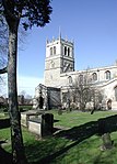 More images |
[34] | |
| St Mary, Tickhill | St Mary's Road, Tickhill | Parish Church | 1390s | 27 December 1962 | SK5917493086 53°25′52″N 1°06′39″W / 53.431248°N 1.110841°W |
1151698 |  More images |
[35] | |
| St John the Baptist, Wadworth | Wadworth, Doncaster | Church | 15th century | 5 June 1968 | SK5687897068 53°28′02″N 1°08′41″W / 53.467288°N 1.144675°W |
1151504 |  More images |
[36] | |
| Wadworth Hall and attached wing walls | Wadworth | House | James Paine | c. 1750 | 5 June 1968 | SK5671197258 53°28′08″N 1°08′50″W / 53.469014°N 1.147156°W |
1314863 |  More images |
[37] |
| All Saints Church, Arksey | Church Lane, Arksey | Church | 15th century | 10 December 1959 | SE5792106926 53°33′21″N 1°07′38″W / 53.555772°N 1.127148°W |
1191878 |  More images |
[38] | |
| St John the Baptist, Mexborough | Church Street, Mexborough | Church | 15th century | 11 April 1986 | SK4797599741 53°29′32″N 1°16′42″W / 53.492197°N 1.278367°W |
1151642 |  More images |
[39] | |
| St Peter, Conisbrough | Church Street, Conisbrough | Church | 15th century | 5 November 1962 | SK5122098754 53°28′59″N 1°13′47″W / 53.483021°N 1.229622°W |
1192787 |  More images |
[40] | |
| Conisbrough Castle | Conisbrough | Castle | c. 1180 | 26 November 1987 | SK5145198901 53°29′04″N 1°13′34″W / 53.48432°N 1.226118°W |
1192747 |  More images |
[41] | |
| St George, Doncaster | Church Lane, Doncaster | Parish Church | George Gilbert Scott | 1854-8 | 12 June 1950 | SE5741703562 53°31′32″N 1°08′07″W / 53.525594°N 1.135371°W |
1151447 |  More images |
[42] |
| Mansion House and attached railings | High Street, Doncaster | House | James Paine and William Lindley | 1748 | 12 June 1950 | SE5750403273 53°31′23″N 1°08′03″W / 53.522987°N 1.134111°W |
1151426 |  More images |
[43] |
Rotherham edit
| Name | Location | Type | Architect | Completed [note 1] | Date designated | Grid ref.[note 2] Geo-coordinates |
Entry number [note 3] | Image | Ref. |
|---|---|---|---|---|---|---|---|---|---|
| All Saints, Aston cum Aughton | Church Lane, Aston cum Aughton | Church | 15th century | 29 March 1968 | SK4681685251 53°21′43″N 1°17′53″W / 53.362067°N 1.297983°W |
1151917 |  More images |
[44] | |
| Catcliffe Glass Cone | Catcliffe, Rotherham | Glass Cone | c. 1740 | 29 March 1968 | SK4254588614 53°23′34″N 1°21′42″W / 53.392654°N 1.361705°W |
1132732 |  More images |
[45] | |
| St John, Dinnington | St John's Road, Dinnington | Church | 15th century | 15 October 1986 | SK5232087572 53°22′57″N 1°12′54″W / 53.382413°N 1.214902°W |
1132698 |  More images |
[46] | |
| All Hallows, Harthill | Union Street, Harthill | Church | 15th century | c. 1200 | 29 July 1966 | SK4936880961 53°19′24″N 1°15′37″W / 53.323278°N 1.260306°W |
1132709 |  More images |
[47] |
| All Saints, Laughton-en-le-Morthen | Church Corner, Laughton-en-le-Morthen | Church | 14th century | 29 March 1968 | SK5170288206 53°23′17″N 1°13′27″W / 53.388172°N 1.224088°W |
1193267 |  More images |
[48] | |
| Sandbeck Park | Maltby | Country House | James Paine | c. 1760 | 13 November 1959 | SK5690190269 53°24′22″N 1°08′44″W / 53.40618°N 1.145555°W |
1314665 |  More images |
[49] |
| St James, Anston | Sheffield Road, Anston | Church | 14th century | 29 July 1966 | SK5196483704 53°20′52″N 1°13′15″W / 53.347683°N 1.220887°W |
1192792 |  More images |
[50] | |
| St Peter, Thorpe Salvin | Harthill Road, Thorpe Salvin | Church | 14th century | 29 July 1966 | SK5204681151 53°19′29″N 1°13′12″W / 53.324729°N 1.220074°W |
1314667 |  More images |
[51] | |
| St Helen, Treeton | Church Lane, Treeton | Church | 15th century | 29 March 1968 | SK4325187709 53°23′04″N 1°21′04″W / 53.384463°N 1.351213°W |
1132728 |  More images |
[52] | |
| The Rockingham Mausoleum including obelisks and railed enclosure | Cortwood Lane, Wentworth | Mausoleum | John Carr of York | 1784–93 | 29 April 1968 | SK4135497030 53°28′06″N 1°22′43″W / 53.468391°N 1.378511°W |
1286386 |  More images |
[53] |
| Stable Block and Riding School | Wentworth Woodhouse, Wentworth | Stables | John Carr of York | 1789 | 29 April 1952 | SK3935597857 53°28′34″N 1°24′31″W / 53.475977°N 1.408519°W |
1203779 |  More images |
[54] |
| Wentworth Woodhouse | Wentworth | Country House | William Etty, Ralph Tunnicliffe, Henry Flitcroft and John Carr of York | 1734 | 29 April 1952 | SK3960897659 53°28′27″N 1°24′17″W / 53.474179°N 1.404732°W |
1132769 | 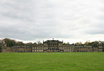 More images |
[55] |
| Rotherham Bridge | Bridge Street, Rotherham | Bridge | John Platt | 15th century | 19 October 1951 | SK4274093061 53°25′57″N 1°21′29″W / 53.432608°N 1.358171°W |
1191884 |  More images |
[56] |
| Chapel of Our Lady, Rotherham | Bridge Street, Rotherham | Chapel | 1824–1888 | 19 October 1951 | SK4274093068 53°25′58″N 1°21′29″W / 53.432671°N 1.358171°W |
1132738 |  More images |
[56] | |
| All Saints, Wath-upon-Dearne | Church Street, Wath-upon-Dearne | Church | 14th century | 13 November 1962 | SE4325300888 53°30′10″N 1°20′58″W / 53.502914°N 1.349376°W |
1132786 |  More images |
[57] | |
| All Saints, Rotherham | Church Street, Rotherham | Church | 16th century | 19 October 1951 | SK4284092879 53°25′51″N 1°21′24″W / 53.430964°N 1.356691°W |
1132733 |  More images |
[58] |
Sheffield edit
| Name | Location | Type | Architect | Completed [note 1] | Date designated | Grid ref.[note 2] Geo-coordinates |
Entry number [note 3] | Image | Ref. |
|---|---|---|---|---|---|---|---|---|---|
| St Nicholas, Bradfield | Towngate, Bradfield | Church | 15th century | 25 April 1969 | SK2671892542 53°25′44″N 1°35′58″W / 53.428995°N 1.59936°W |
1192617 | 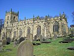 More images |
[59] | |
| St Mary, Ecclesfield | Church Street, Ecclesfield | Church | 15th century | 25 April 1969 | SK3530294221 53°26′37″N 1°28′12″W / 53.443583°N 1.469988°W |
1192775 |  More images |
[60] | |
| Abbeydale Industrial Hamlet | Abbeydale Road South, Sheffield | Crucible Furnace | c1800-1830 | 1 May 1952 | SK3259781939 53°20′00″N 1°30′43″W / 53.333363°N 1.511974°W |
1246418 |  More images |
[61] | |
| Sheffield Cathedral | Church Street, Sheffield | Cathedral | William Flockton, Charles Nicholson, etc. | 1480s | 1 May 1952 | SK3538187490 53°22′59″N 1°28′10″W / 53.383078°N 1.469552°W |
1247080 |  More images |
[62] |
| Sheffield Town Hall | Pinstone Street, Sheffield | Town Hall | E. W. Mountford | 1890–1897 | 28 June 1973 | SK3536187189 53°22′49″N 1°28′12″W / 53.380374°N 1.469886°W |
1246902 |  More images |
[63] |
See also edit
- Category:Grade I listed buildings in South Yorkshire
- Scheduled Monument
- Conservation in the United Kingdom
- Listed buildings in Sheffield
- List of tallest buildings in Sheffield
Notes edit
- A Sometimes known as OSGB36, the grid reference is based on the British national grid reference system, and is the system used by the Ordnance Survey.[64][65]
- B Images of England, funded by English Heritage and the Heritage Lottery Fund, is a photographic record of England's listed buildings, but it is not an up-to-date record. The listing status and descriptions shown are as at February 2001.
- ^ a b c d The date given is the date used by Historic England as significant for the initial building or that of an important part in the structure's description.
- ^ a b c d Sometimes known as OSGB36, the grid reference is based on the British national grid reference system used by the Ordnance Survey.
- ^ a b c d The "List Entry Number" is a unique number assigned to each listed building and scheduled monument by Historic England.
References edit
- ^ "What is a listed building?". Manchester City Council. Retrieved 8 December 2007.
- ^ "Planning (Listed Buildings and Conservation Areas) Act 1990 (c. 9)". Ministry of Justice. Retrieved 17 December 2007.
- ^ Historic England. "Gunthwaite Hall (1151106)". National Heritage List for England. Retrieved 15 January 2008.
- ^ Historic England. "Wortley Top Forge (1315032)". National Heritage List for England. Retrieved 15 January 2008.
- ^ Historic England. "Church of St John, Market Place (1314709)". National Heritage List for England. Retrieved 15 January 2008.
- ^ Historic England. "Church of All Saints, High Street (1151740)". National Heritage List for England. Retrieved 15 January 2008.
- ^ Historic England. "Wentworth Castle (1151065)". National Heritage List for England. Retrieved 15 January 2008.
- ^ Historic England. "Administration Building at Monk Bretton Priory (1151179)". National Heritage List for England. Retrieved 15 January 2008.
- ^ Historic England. "Church of All Saints, Church Street (1286515)". National Heritage List for England. Retrieved 15 January 2008.
- ^ Historic England. "Church of All Saints, Church Street (1315015)". National Heritage List for England. Retrieved 15 January 2008.
- ^ Historic England. "Church of St Andrew, High Street (1191492)". National Heritage List for England. Retrieved 15 January 2008.
- ^ Historic England. "Church of St John the Baptist, Church Street (1151127)". National Heritage List for England. Retrieved 15 January 2008.
- ^ Historic England. "Church of St Mary Worsborough (1315083)". National Heritage List for England. Retrieved 15 January 2008.
- ^ Historic England. "Gatehouse to Monk Bretton Priory (1315023)". National Heritage List for England. Retrieved 15 January 2008.
- ^ Historic England. "Monk Bretton Priory Remains (1151178)". National Heritage List for England. Retrieved 15 January 2008.
- ^ Historic England. "Church of St Peter, Barnburgh (1151675)". National Heritage List for England. Retrieved 16 January 2008.
- ^ Historic England. "Church of St Peter and St Paul, Church Road (1151488)". National Heritage List for England. Retrieved 16 January 2008.
- ^ Historic England. "Church of St Nicholas, Church Road (1314824)". National Heritage List for England. Retrieved 16 January 2008.
- ^ Historic England. "Brodsworth Hall (1191614)". National Heritage List for England. Retrieved 16 January 2008.
- ^ Historic England. "Church of St Helen, Grange Lane (1151457)". National Heritage List for England. Retrieved 16 January 2008.
- ^ Historic England. "Church of St Peter, Edlington Lane (1286332)". National Heritage List for England. Retrieved 16 January 2008.
- ^ Historic England. "Church of Holy Trinity and St Oswald, Rectory Lane (1286821)". National Heritage List for England. Retrieved 16 January 2008.
- ^ Historic England. "Church of St Cuthbert, Church Lane (1314801)". National Heritage List for England. Retrieved 16 January 2008.
- ^ Historic England. "Church of St Lawrence (1192628)". National Heritage List for England. Retrieved 12 December 2014.
- ^ Historic England. "Hatfield Manor House (1151589)". National Heritage List for England. Retrieved 12 December 2014.
- ^ Historic England. "Church of St Wilfrid Hickleton (1314784)". National Heritage List for England. Retrieved 16 January 2008.
- ^ Historic England. "Church of All Saints Hooton Pagnell (1314808)". National Heritage List for England. Retrieved 16 January 2008.
- ^ Historic England. "Church of St Helen, Church Lane (1192644)". National Heritage List for England. Retrieved 16 January 2008.
- ^ Historic England. "Church of St Mary Magdalene, High Street (1151464)". National Heritage List for England. Retrieved 16 January 2008.
- ^ Historic England. "The Old Rectory, High Street (1286761)". National Heritage List for England. Retrieved 16 January 2008.
- ^ Historic England. "Church of All Saints (1192336)". National Heritage List for England. Retrieved 12 December 2014.
- ^ Historic England. "Church of St Mary, Sprotborough (1192663)". National Heritage List for England. Retrieved 16 January 2008.
- ^ Historic England. "Cusworth Hall (1192735)". National Heritage List for England. Retrieved 16 January 2008.
- ^ Historic England. "Church of St Nicholas, Stonegate (1193076)". National Heritage List for England. Retrieved 16 January 2008.
- ^ Historic England. "Church of St Mary, St Mary's Road (1151698)". National Heritage List for England. Retrieved 16 January 2008.
- ^ Historic England. "Church of St John the Baptist (1151504)". National Heritage List for England. Retrieved 12 December 2014.
- ^ Historic England. "Wadworth Hall and attached wing walls (1314863)". National Heritage List for England. Retrieved 12 December 2014.
- ^ Historic England. "Church of All Saints, Church Lane (1191878)". National Heritage List for England. Retrieved 16 January 2008.
- ^ Historic England. "Church of St John the Baptist, Church Street (1151642)". National Heritage List for England. Retrieved 16 January 2008.
- ^ Historic England. "Church of St Peter, Church Street (1192787)". National Heritage List for England. Retrieved 16 January 2008.
- ^ Historic England. "Conisbrough Castle (1192747)". National Heritage List for England. Retrieved 16 January 2008.
- ^ Historic England. "St George's Church, Church Lane (1151447)". National Heritage List for England. Retrieved 16 January 2008.
- ^ Historic England. "The Mansion House and attached railings (1151426)". National Heritage List for England. Retrieved 16 January 2008.
- ^ Historic England. "Church of All Saints, Church Lane (1151917)". National Heritage List for England. Retrieved 15 January 2008.
- ^ Historic England. "The Glassworks Cone (1132732)". National Heritage List for England. Retrieved 15 January 2008.
- ^ Historic England. "Church of St John, St John's Road (1132698)". National Heritage List for England. Retrieved 15 January 2008.
- ^ Historic England. "Church of All Hallows, Union Street (1132709)". National Heritage List for England. Retrieved 15 January 2008.
- ^ Historic England. "Church of All Saints, Church Corner (1193267)". National Heritage List for England. Retrieved 15 January 2008.
- ^ Historic England. "Sandbeck Park (house) (1314665)". National Heritage List for England. Retrieved 15 January 2008.
- ^ Historic England. "Church of St James, Sheffield Road (1192792)". National Heritage List for England. Retrieved 15 January 2008.
- ^ Historic England. "Church of St Peter, Harthill Road (1314667)". National Heritage List for England. Retrieved 15 January 2008.
- ^ Historic England. "Church of St Helen, Church Lane (1132728)". National Heritage List for England. Retrieved 15 January 2008.
- ^ Historic England. "Rockingham Mausoleum including obelisks and railed enclosure (1286386)". National Heritage List for England. Retrieved 15 January 2008.
- ^ Historic England. "Stable Block and Riding School (1203779)". National Heritage List for England. Retrieved 15 January 2008.
- ^ Historic England. "Wentworth Woodhouse (1132769)". National Heritage List for England. Retrieved 15 January 2008.
- ^ a b Historic England. "Rotherham Bridge (1191884)". National Heritage List for England. Retrieved 15 January 2008.
- ^ Historic England. "Church of All Saints, Church Street (1132786)". National Heritage List for England. Retrieved 15 January 2008.
- ^ Historic England. "Church of All Saints, Church Street (1132733)". National Heritage List for England. Retrieved 15 January 2008.
- ^ Historic England. "Church of St Nicholas, Towngate (1192617)". National Heritage List for England. Retrieved 15 January 2008.
- ^ Historic England. "Church of St Mary, Church Street (1192775)". National Heritage List for England. Retrieved 15 January 2008.
- ^ Historic England. "Abbeydale Works Museum (1246418)". National Heritage List for England. Retrieved 15 January 2008.
- ^ Historic England. "Cathedral Church of St Peter and St Paul and attached wall and gates (1247080)". National Heritage List for England. Retrieved 15 January 2008.
- ^ Historic England. "Town Hall, Pinstone Street (1246902)". National Heritage List for England. Retrieved 15 January 2008.
- ^ "Guide to National Grid". Ordnance Survey. Archived from the original on 27 October 2007. Retrieved 12 December 2007.
- ^ "Get-a-map". Ordnance Survey. Retrieved 17 December 2007.
External links edit
![]() Media related to Grade I listed buildings in South Yorkshire at Wikimedia Commons
Media related to Grade I listed buildings in South Yorkshire at Wikimedia Commons