


Summary
West Somerset is a local government district in the English county of Somerset. In the United Kingdom, the term listed building refers to a building or other structure officially designated as being of special architectural, historical or cultural significance; Grade I structures are those considered to be "buildings of exceptional interest".[1] Listing was begun by a provision in the Town and Country Planning Act 1947. Once listed, severe restrictions are imposed on the modifications allowed to a building's structure or its fittings. In England, the authority for listing under the Planning (Listed Buildings and Conservation Areas) Act 1990[2] rests with Historic England, a non-departmental public body sponsored by the Department for Digital, Culture, Media and Sport; local authorities have a responsibility to regulate and enforce the planning regulations.
The district of West Somerset covers a largely rural area, with a population, according to the 2011 census, of 35,300[3] in an area of 740 square kilometres (290 sq mi).[4] The largest centres of population are the coastal towns of Minehead and Watchet. The council's administrative headquarters are in the village of Williton.
There are 33 Grade I listed buildings in West Somerset. The oldest is either Culbone Church, one of the smallest churches in England,[5] and pre-Norman in origin,[6] or Tarr Steps, which may originate in the Bronze Age, although other sources date them from around 1400.[7] Dunster has the greatest concentration of Grade I listed buildings, including Dunster Castle, which was built in 1617 on a site which had supported a castle for the previous 600 years;[8] the Yarn Market, which was built in 1609;[9] Gallox Bridge, which dates from the 15th century[10] and the Priory Church of St George which is predominantly from the 15th century but includes part of the earlier church on the same site.[11] Other sites include manor houses such as the medieval buildings at Nettlecombe Court[12] and Orchard Wyndham.[13] Somerset has many religious structures, most of which are from the Norman or medieval eras. Some of the churches are part of the Somerset towers, a collection mostly spireless Gothic church towers.
Buildings edit
| Name | Location | Type | Completed [note 1] | Grid ref.[note 2] Geo-coordinates |
Entry number [note 3] | Image | Ref. |
|---|---|---|---|---|---|---|---|
| All Saints Church | Dodington | Parish Church | 15th century | ST1719840561 51°09′30″N 3°11′08″W / 51.158287°N 3.185423°W |
1057420 |  More images |
[14]
|
| Bratton Court | Minehead Without | Manor House | 14th century | SS9460346291 51°12′22″N 3°30′36″W / 51.206072°N 3.5101°W |
1174996 |  More images |
[15] |
| Church of All Saints | Monksilver | Parish Church | 12th century | ST0727937429 51°07′43″N 3°19′35″W / 51.128608°N 3.326416°W |
1296069 |  More images |
[16] |
| Church of All Saints | Selworthy | Parish Church | 14th century | SS9198446807 51°12′37″N 3°32′52″W / 51.210221°N 3.547731°W |
1296005 |  More images |
[17] |
| Church of All Saints | Wootton Courtenay | Parish Church | 13th century | SS9383143437 51°10′49″N 3°31′13″W / 51.180275°N 3.520302°W |
1345750 |  More images |
[18]
|
| Church of St Andrew | Old Cleeve | Parish Church | 12th century | ST0409741914 51°10′06″N 3°22′23″W / 51.168401°N 3.373071°W |
1295868 |  More images |
[19] |
| Church of St Andrew | Stogursey | Parish Church | 1107 | ST2047442876 51°10′46″N 3°08′21″W / 51.179564°N 3.1391°W |
1057404 | 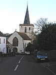 More images |
[20] |
| Church of St Decuman | Watchet | Parish Church | 13th century | ST0649842709 51°10′33″N 3°20′20″W / 51.175945°N 3.338947°W |
1057662 | 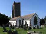 More images |
[21]
|
| Church of St Dubricius | Porlock | Parish Church | 13th century | SS8863946664 51°12′30″N 3°35′44″W / 51.208292°N 3.595554°W |
1173524 |  More images |
[22]
|
| Church of St George | Bicknoller | Parish Church | 15th century | ST1107539428 51°08′50″N 3°16′22″W / 51.147181°N 3.272677°W |
1057465 |  More images |
[23] |
| Church of St John the Baptist | Carhampton | Parish Church | 1863 | ST0093042658 51°10′28″N 3°25′07″W / 51.174548°N 3.418559°W |
1345731 |  More images |
[24] |
| Church of St Mary | Luccombe | Parish Church | c. 1300 | SS9109044521 51°11′22″N 3°33′35″W / 51.189503°N 3.55983°W |
1057328 |  More images |
[25] |
| Church of St Mary | Stogumber | Parish Church | 13th century | ST0981237291 51°07′40″N 3°17′25″W / 51.127772°N 3.290193°W |
1057500 |  More images |
[26] |
| Church of St Mary Magdalene | Winsford | Parish Church | 13th century | SS9046134986 51°06′13″N 3°33′57″W / 51.103676°N 3.565923°W |
1174169 |  More images |
[27]
|
| Church of St Mary the Virgin | Nettlecombe | Parish Church | 13th century | ST0568337749 51°07′52″N 3°20′57″W / 51.131224°N 3.349301°W |
1173837 |  More images |
[28]
|
| Church of St Nicholas | Brushford | Parish Church | 15th century | SS9194925738 51°01′15″N 3°32′31″W / 51.020829°N 3.541913°W |
1263949 |  More images |
[29] |
| Church of St Nicholas | Withycombe | Parish Church | 13th century | ST0153041301 51°09′45″N 3°24′35″W / 51.162454°N 3.409607°W |
1057311 |  More images |
[30] |
| Church of St Peter | Huish Champflower | Parish Church | 15th century | ST0491029200 51°03′15″N 3°21′29″W / 51.054244°N 3.358091°W |
1248030 | 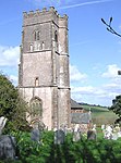 More images |
[31] |
| Church of St Petrock | Timberscombe | Parish Church | 15th century | SS9559742055 51°10′05″N 3°29′41″W / 51.168178°N 3.494644°W |
1057303 |  More images |
[32] |
| Church of the Holy Ghost | Crowcombe | Parish Church | 14th century | ST1407336710 51°07′24″N 3°13′45″W / 51.123205°N 3.229179°W |
1174327 |  More images |
[33] |
| Cleeve Abbey | Washford | Remains of Cistercian abbey | 1198 | ST0474440703 51°09′27″N 3°21′49″W / 51.157623°N 3.363499°W |
1057579 |  More images |
[34]
|
| Combe Sydenham | Stogumber | Manor House | Late 15th century | ST0761236743 51°07′21″N 3°19′17″W / 51.122495°N 3.321482°W |
1057497 |  More images |
[35] |
| Court House | East Quantoxhead | Manor House | 1614 | ST1364243687 51°11′09″N 3°14′13″W / 51.185863°N 3.237012°W |
1057409 | 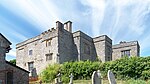 More images |
[36]
|
| Crowcombe Court and attached stables to west | Crowcombe | Country House | 1793 | ST1399536916 51°07′30″N 3°13′49″W / 51.125045°N 3.230342°W |
1345656 |  More images |
[37] |
| Culbone Church | Culbone | Parish Church | Pre-Norman | SS8421648226 51°13′17″N 3°39′34″W / 51.221451°N 3.659347°W |
1058037 | 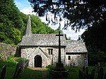 More images |
[38] |
| Dunster Castle and gatehouse | Dunster | Castle | 11th century | SS9919643490 51°10′54″N 3°26′37″W / 51.181724°N 3.443589°W |
1057643 |  More images |
[8] |
| Gallox Bridge | Dunster | 15th century | SS9895143213 51°10′45″N 3°26′49″W / 51.179191°N 3.447015°W |
1296207 |  More images |
[10] | |
| Gatehouse and barn abutting west end at Bratton Court | Minehead Without | Gatehouse and barn | 14th century | SS9461946319 51°12′23″N 3°30′36″W / 51.206327°N 3.509879°W |
1345727 |  |
[39] |
| Nettlecombe Court (Leonard Wills Field Centre) |
Nettlecombe | Late medieval | ST0564637755 51°07′53″N 3°20′59″W / 51.131271°N 3.349831°W |
1173856 |  (Leonard Wills Field Centre) More images |
[12] | |
| Orchard Wyndham and belvedere adjoining to north east | Williton | Country House | Medieval | ST0721439931 51°09′04″N 3°19′41″W / 51.151089°N 3.32799°W |
1295578 | 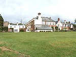 More images |
[13] |
| Priory Church of St George | Dunster | Parish Church | 15th century | SS9903943663 51°11′00″N 3°26′45″W / 51.183251°N 3.445883°W |
1057646 |  More images |
[11] |
| Tarr Steps | Dulverton | Clapper bridge | Medieval | SS8677032116 51°04′38″N 3°37′04″W / 51.077161°N 3.617719°W |
1247822 |  More images |
[40]
|
| Yarn Market | Dunster | 1609 | SS9915243812 51°11′05″N 3°26′40″W / 51.184611°N 3.444308°W |
1173428 | 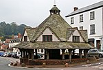 More images |
[9] |
See also edit
Notes edit
- ^ The date given is the date used by Historic England as significant for the initial building or that of an important part in the structure's description.
- ^ Sometimes known as OSGB36, the grid reference is based on the British national grid reference system used by the Ordnance Survey.
- ^ The "List Entry Number" is a unique number assigned to each listed building and scheduled monument by Historic England.
References edit
- ^ "Listed Buildings". Historic England. Retrieved 23 August 2017.
- ^ "Planning (Listed Buildings and Conservation Areas) Act 1990 (c. 9)". Ministry of Justice. Archived from the original on 18 April 2010. Retrieved 17 December 2007.
- ^ "Statistics & Census Information". West Somerset Council. Retrieved 22 October 2017.
- ^ "West Somerset (Local Authority): Key Figures for Physical Environment". Neighbourhood Statistics. Office for National Statistics. Retrieved 23 April 2009.
- ^ "Parish Churches". Somerset County archives. Archived from the original on 5 October 2013. Retrieved 24 October 2007.
- ^ Historic England. "Culbone church (1058037)". National Heritage List for England. Retrieved 24 October 2007.
- ^ "Tarr Steps". Everything Exmoor. Retrieved 23 April 2009.
- ^ a b Historic England. "Dunster Castle and gatehouse (1057643)". National Heritage List for England. Retrieved 3 April 2015.
- ^ a b Historic England. "Yarn Market (1173428)". National Heritage List for England. Retrieved 3 April 2015.
- ^ a b Historic England. "Gallox Bridge (1296207)". National Heritage List for England. Retrieved 3 April 2015.
- ^ a b Historic England. "Priory Church of St George (1057646)". National Heritage List for England. Retrieved 3 April 2015.
- ^ a b Historic England. "Leonard Wills Field Centre (1173856)". National Heritage List for England. Retrieved 3 April 2015.
- ^ a b Historic England. "Orchard Wyndham (1295578)". National Heritage List for England. Retrieved 3 April 2015.
- ^ Historic England. "All Saints Church (1057420)". National Heritage List for England. Retrieved 3 April 2015.
- ^ Historic England. "Bratton Court (1174996)". National Heritage List for England. Retrieved 3 April 2015.
- ^ Historic England. "Church of All Saints (1296069)". National Heritage List for England. Retrieved 3 April 2015.
- ^ Historic England. "Church of All Saints (1296005)". National Heritage List for England. Retrieved 3 April 2015.
- ^ Historic England. "Church of All Saints (1345750)". National Heritage List for England. Retrieved 3 April 2015.
- ^ Historic England. "Church of St Andrew (1295868)". National Heritage List for England. Retrieved 3 April 2015.
- ^ Historic England. "Church of St Andrew (1057404)". National Heritage List for England. Retrieved 3 April 2015.
- ^ Historic England. "Church of St Decuman (1057662)". National Heritage List for England. Retrieved 3 April 2015.
- ^ Historic England. "Church of St Dubricius (1173524)". National Heritage List for England. Retrieved 3 April 2015.
- ^ Historic England. "Church of St George (1057465)". National Heritage List for England. Retrieved 3 April 2015.
- ^ Historic England. "Church of St John the Baptist (1345731)". National Heritage List for England. Retrieved 3 April 2015.
- ^ Historic England. "Church of St Mary (1057328)". National Heritage List for England. Retrieved 3 April 2015.
- ^ Historic England. "Church of St Mary (1057500)". National Heritage List for England. Retrieved 3 April 2015.
- ^ Historic England. "Church of St Mary Magdalene (1174169)". National Heritage List for England. Retrieved 3 April 2015.
- ^ Historic England. "Church of St Mary the Virgin (1173837)". National Heritage List for England. Retrieved 3 April 2015.
- ^ Historic England. "Church of St Nicholas (1263949)". National Heritage List for England. Retrieved 3 April 2015.
- ^ Historic England. "Church of St Nicholas (1057311)". National Heritage List for England. Retrieved 3 April 2015.
- ^ Historic England. "Church of St Peter (1248030)". National Heritage List for England. Retrieved 3 April 2015.
- ^ Historic England. "Church of St Petrock (1057303)". National Heritage List for England. Retrieved 3 April 2015.
- ^ Historic England. "Church of the Holy Ghost (1174327)". National Heritage List for England. Retrieved 3 April 2015.
- ^ Historic England. "Cleeve Abbey (1057579)". National Heritage List for England. Retrieved 3 April 2015.
- ^ Historic England. "Combe Sydenham (1057497)". National Heritage List for England. Retrieved 3 April 2015.
- ^ Historic England. "Court House (1057409)". National Heritage List for England. Retrieved 3 April 2015.
- ^ Historic England. "Crowcombe Court and attached stables to west (1345656)". National Heritage List for England. Retrieved 3 April 2015.
- ^ Historic England. "Culbone Church (1058037)". National Heritage List for England. Retrieved 3 April 2015.
- ^ Historic England. "Gatehouse and barn abutting west end at Bratton Court (1345727)". National Heritage List for England. Retrieved 3 April 2015.
- ^ Historic England. "Tarr Steps (1247822)". National Heritage List for England. Retrieved 3 April 2015.
External links edit
- West Somerset Council listed building information