


Summary
There are over 9,300 Grade I listed buildings in England. This page is a list of these buildings in the county of Isle of Wight.
In the United Kingdom, the term listed building refers to a building or other structure officially designated as being of special architectural, historical, or cultural significance; Grade I structures are those considered to be "buildings of exceptional interest".[1] Listing was begun by a provision in the Town and Country Planning Act 1947. Once listed, strict limitations are imposed on the modifications allowed to a building's structure or fittings. In England, the authority for listing under the Planning (Listed Buildings and Conservation Areas) Act 1990[2] rests with English Heritage, a non-departmental public body sponsored by the Department for Culture, Media and Sport; local authorities have a responsibility to regulate and enforce the planning regulations.
Buildings edit
| Name | Location | Type | Architect | Completed [note 1] | Date designated | Grid ref.[note 2] Geo-coordinates |
Entry number [note 3] | Image |
|---|---|---|---|---|---|---|---|---|
| St. Mary's Church | Brading | Parish church | c. 1200 | 18 January 1967 | SZ6066287316 50°40′56″N 1°08′34″W / 50.682348°N 1.142726°W |
1034341 | 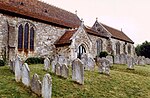 More images
| |
| Bembridge Windmill | Bembridge | Tower mill | c. 1700 | 16 April 1953 | SZ6398087476 50°41′00″N 1°05′45″W / 50.683432°N 1.09574°W |
1034383 |  More images
| |
| Newport Minster | Newport | Parish church | 1855 | 1 October 1953 | SZ4997389145 50°41′59″N 1°17′38″W / 50.699808°N 1.293763°W |
1034494 | 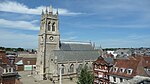 More images
| |
| Roman Villa in the Grounds of St Mary's Vicarage | Clatterford Road, Newport | Villa | 1445 | 1 February 1972 | SZ4850988085 50°41′25″N 1°18′53″W / 50.6904°N 1.31463°W |
1034633 |  Upload Photo | |
| Carisbrooke Castle | Newport | Castle | 1 February 1972 | SZ4859487774 50°41′15″N 1°18′48″W / 50.687597°N 1.313467°W |
1034657 |  More images
| ||
| Roman Villa | Newport | Villa | 1445 | 1 February 1972 | SZ5011688536 50°41′40″N 1°17′31″W / 50.69432°N 1.29182°W |
1034658 |  More images
| |
| St. George's Church | Arreton | Parish church | 18 January 1967 | SZ5344386761 50°40′41″N 1°14′42″W / 50.678063°N 1.244977°W |
1209193 |  More images
| ||
| All Saints' Church | Church Hill, Godshill | Parish church | 18 January 1967 | SZ5272381826 50°38′02″N 1°15′21″W / 50.633753°N 1.255868°W |
1209229 |  More images
| ||
| St. Peter's Church | Main Road, Shorwell | Parish church | 18 January 1967 | SZ4573282996 50°38′42″N 1°21′16″W / 50.644863°N 1.354568°W |
1209404 |  More images
| ||
| Appuldurcombe House | Appuldurcombe Road, Godshill | Country House | John James | 1713 | 21 July 1951 | SZ5431979973 50°37′01″N 1°14′01″W / 50.616945°N 1.233573°W |
1218394 | 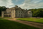 More images
|
| Farringford Hotel | Freshwater | House | 18 January 1967 | SZ3372786157 50°40′27″N 1°31′27″W / 50.674105°N 1.524062°W |
1219039 |  More images
| ||
| Roman Villa | Brading | Villa | 18 January 1967 | SZ5995986269 50°40′23″N 1°09′10″W / 50.673006°N 1.152845°W |
1219584 |  More images
| ||
| Church of St. Michael the Archangel | Shalfleet | Parish church | c. 1070 | 18 January 1967 | SZ4137789233 50°42′05″N 1°24′56″W / 50.701273°N 1.415462°W |
1219684 |  More images
| |
| Church of St. John the Baptist | Northwood | Church | 17 August 1951 | SZ4937892956 50°44′03″N 1°18′06″W / 50.734127°N 1.301678°W |
1222705 |  More images
| ||
| Norris Castle Farm, The Bailiff's House, two cottages & kitchen garden wall | East Cowes | House | c. 1800 | 17 August 1951 | SZ5150095837 50°45′35″N 1°16′16″W / 50.759849°N 1.27121°W |
1223182 | Upload Photo | |
| Osborne House | Whippingham Road, East Cowes | House | 9 August 1979 | SZ5159294802 50°45′02″N 1°16′12″W / 50.750534°N 1.27005°W |
1223802 |  More images
| ||
| Quarr Abbey | Fishbourne | Abbey | 1907 | 18 May 1972 | SZ5621392726 50°43′53″N 1°12′18″W / 50.731439°N 1.20487°W |
1235008 |  More images
| |
| Norris Castle | Newbarn Road, East Cowes | House | 1799 | 17 August 1951 | SZ5154496198 50°45′47″N 1°16′14″W / 50.763091°N 1.270536°W |
1267468 | 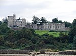 More images
| |
| St. Mildred's Church | Beatrice Avenue, Whippingham | Church | 1862 | 17 August 1951 | SZ5112193607 50°44′23″N 1°16′37″W / 50.739831°N 1.276892°W |
1267717 | 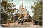 More images
| |
| Parish Church of St Mary | Newport | Parish church | 1 October 1953 | SZ4855788250 50°41′31″N 1°18′50″W / 50.69188°N 1.313929°W |
1278134 |  More images
| ||
| All Saints' Church | Newchurch | Parish church | 14 February 1992 | SZ5618585554 50°40′01″N 1°12′23″W / 50.666953°N 1.206356°W |
1290840 | 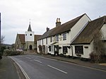 More images
| ||
| Golden Hill Fort | Freshwater | Bridge | 1872 | 28 March 1994 | SZ3385787862 50°41′22″N 1°31′19″W / 50.689429°N 1.522067°W |
1291516 | 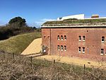 More images
| |
| St. Mary's Church | Main Road, Brighstone | Church | 1727 | 18 January 1967 | SZ4290482697 50°38′33″N 1°23′41″W / 50.642389°N 1.394597°W |
1292128 |  More images
| |
| Yarmouth Castle | Yarmouth | Moat | c. 1670 | 28 March 1994 | SZ3538889774 50°42′24″N 1°30′01″W / 50.706532°N 1.500211°W |
1292631 |  More images
| |
| Wolverton Manor | Pound Lane, Shorwell | Moat | 21 July 1951 | SZ4528582448 50°38′24″N 1°21′39″W / 50.639971°N 1.360956°W |
1292659 | 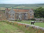 More images
| ||
| St. Peter and St. Paul's Church | Mottistone, Brighstone | Parish church | 18 January 1967 | SZ4055583721 50°39′06″N 1°25′40″W / 50.651765°N 1.427704°W |
1292718 |  More images
| ||
| St. Olave's Church | Gatcombe | Parish church | 18 January 1967 | SZ4924085094 50°39′48″N 1°18′17″W / 50.663444°N 1.304679°W |
1292758 |  More images
| ||
| Church of St. John the Baptist | Yaverland | Parish church | 1150 | SZ6139585942 50°40′12″N 1°07′57″W / 50.669916°N 1.13258°W |
1365369 |  More images
| ||
| Yaverland Manor | Sandown | Manor House | c. 1620 | 14 March 1949 | SZ6142285938 50°40′12″N 1°07′56″W / 50.669877°N 1.132199°W |
1365370 |  More images
|
See also edit
Notes edit
- ^ The date given is the date used by Historic England as significant for the initial building or that of an important part in the structure's description.
- ^ Sometimes known as OSGB36, the grid reference is based on the British national grid reference system used by the Ordnance Survey.
- ^ The "List Entry Number" is a unique number assigned to each listed building and scheduled monument by Historic England.
References edit
External links edit
![]() Media related to Grade I listed buildings on the Isle of Wight at Wikimedia Commons
Media related to Grade I listed buildings on the Isle of Wight at Wikimedia Commons
- National Heritage List for England