


Summary
Handa Island[6] (Scottish Gaelic: Eilean Shannda) or simply Handa is an island off the west coast of Sutherland, Scotland. It is 309 hectares (760 acres) and 123 metres (404 ft) at its highest point.
| Scottish Gaelic name | Eilean Shannda |
|---|---|
| Old Norse name | Sandey |
| Meaning of name | Island at the sandy river[1] |
| Location | |
 Handa Island Handa Island shown within Sutherland | |
| OS grid reference | NC138480 |
| Coordinates | 58°22′48″N 5°11′10″W / 58.380°N 05.186°W |
| Physical geography | |
| Island group | Inner Hebrides/Islands of Sutherland |
| Area | 309 hectares (1+3⁄16 sq mi) |
| Area rank | 87= [2] |
| Highest elevation | Sithean Mòr, 123 m (404 ft) |
| Administration | |
| Sovereign state | United Kingdom |
| Country | Scotland |
| Demographics | |
| Population | 0 |
| References | [3][4][5] |
The island is of national importance for its birdlife and maritime vegetation, and is a Scottish Wildlife Trust nature reserve, a Site of Special Scientific Interest (SSSI), and a Special Protection Area (SPA).[7][8] Handa also forms part of the North-West Sutherland national scenic area, one of 40 such areas in Scotland.[9]
A small ferry sails to Handa from Tarbet on the mainland and boat trips operate to it from Fanagmore. The island receives five thousand visitors per annum.[4]
Geography and geology edit

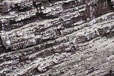
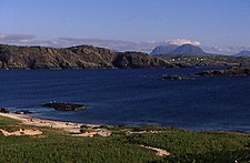
Handa is composed of Torridonian red sandstone[4] and surrounded by cliffs covered with birds. In the north is a hill with two peaks, with the south and east being lower lying. The north and west have 100-metre-high (330 ft) cliffs, and there are beaches in the south and east. The Sound of Handa separates it from the mainland and smaller islands around Handa include Glas-Leac to the south, Eilean an Aigeach to the north east and Stac an t-Sealbhaig to the north.
Flora and fauna edit
Handa is noted for its birdlife, which includes puffins, razorbills and guillemots. The SPA designation lists six priority species: fulmar, great skua, guillemot, kittiwake, and razorbill.[10] The breeding colonies of razorbills and guillemots on Handa are the largest in the UK, representing 11% and 9% of the total British population respectively. The arctic skua and kittiwake populations are also of national importance, representing >1% and 2% of the British population respectively.[11] Other birds at Handa include eider ducks and oystercatchers, and seals and otters can often be seen at Boulder Bay on the island's southern coast. Dolphins, basking sharks and several species of whale regularly visit the seas surrounding Handa.[12]
Handa is also of national importance for its maritime vegetation. The exposed cliff tops are home to maritime grassland species that can tolerate salt, such as thrift, sea plantain and Festuca rubra. In less exposed areas can be found herb-rich grasslands which support species such as Yorkshire fog, bluebell and Scots lovage. Heather and crowberry are also widespread across the island.[11]
History edit
The island's name is of mixed Gaelic and Norse origin and means "island at the sandy river".[1]
Anciently the island was used as a burial place, and there are still the remains of a chapel in the south east, commemorated in the name Tràigh an Teampaill (Beach of the Temple). The use of Handa as burial place is thought to be due to the fact that wolves would dig up graves on the mainland so frequently that the inhabitants of Eddrachillis resorted to burying their dead on the island:[13]
- On Ederachillis’ shore
- The grey wolf lies in wait,—
- Woe to the broken door,
- Woe to the loosened gate,
- And the groping wretch whom sleety fogs
- On the trackless moor belate.
- Thus every grave we dug
- The hungry wolf uptore,
- And every morn the sod
- Was strewn with bones and gore:
- Our mother-earth had denied us rest
- On Ederchaillis’ shore
— The Book of Highland Minstrelsy, 1846[14]
It had a population of 65 in 1841,[4] but following the 1847 Highland Potato Famine the inhabitants emigrated to Nova Scotia.[12] In some ways this is surprising, since it is recorded that the islanders had a fairly varied diet including oats, fish and seabirds, rather than depending heavily on a potato crop. The islanders had a parliament, similar to that of St Kilda, which met daily, and the oldest widow on the island was considered its "Queen".[4]
The Great Stack of Handa was first climbed from the sea on 1 August 1969 by Graeme Hunter, Hamish MacInnes and Douglas Lang.[15]
The island is now part of the Scourie Estate, owned by Dr Jean Balfour and J.C. Balfour.[16] The Balfours leased Handa to the RSPB for 25 years, however this lease was not renewed, because the Balfours wished a Scottish-based body to run the island; as a result the Scottish Wildlife Trust (SWT) took it over.[4] Under the SWT the island is managed by one warden and a handful of volunteers during the summer months.[17]
Gallery edit
-
 Cliff with breeding guillemots
 -
 Northern fulmar (Fulmarus glacialis) at Handa Island
 -
 Puffin (Fratercula arctica) at Handa Island
 -
 Great skua (Stercorarius skua) at Handa Island
 -
 Sign for the breeding birds' protected area
 -


See also edit
Footnotes edit
- ^ a b Mac an Tàilleir, Iain (2003) Ainmean-àite/Placenames. (pdf) Pàrlamaid na h-Alba. Retrieved 26 August 2012.
- ^ Area and population ranks: there are c. 300 islands over 20 ha in extent and 93 permanently inhabited islands were listed in the 2011 census.
- ^ General Register Office for Scotland (28 November 2003) Scotland's Census 2001 – Occasional Paper No 10: Statistics for Inhabited Islands. Retrieved 26 February 2012.
- ^ a b c d e f Haswell-Smith, Hamish (2004). The Scottish Islands. Edinburgh: Canongate. ISBN 978-1-84195-454-7.
- ^ Ordnance Survey
- ^ "Handa Island". Ordnance Survey. Retrieved 15 February 2020.
- ^ "Handa Island SSSI". Scottish Natural Heritage. Retrieved 13 May 2019.
- ^ "Handa SPA". Scottish Natural Heritage. Retrieved 13 May 2019.
- ^ "National Scenic Areas" Archived 11 March 2017 at the Wayback Machine. SNH. Retrieved 30 Mar 2011.
- ^ "Site Details for Handa SPA". Scottish Natural Heritage. 2 May 2018. Retrieved 16 May 2018.
- ^ a b "Handa Island SSSI Citation". Scottish Natural Heritage. Retrieved 13 May 2019.
- ^ a b "Handa Island Wildlife Reserve: Visitor Leaflet" (PDF). Scottish Wildlife Trust. Retrieved 14 May 2019.
- ^ Wildlife in Britain and Ireland by Richard Perry, published by Taylor and Francis, 1978
- ^ Ogilvy, Eliza Ann H. (1846) The Book of Highland Minstrelsy. G.W. Nickisson. pp. 256-58
- ^ The Mini Stac was also climbed by Graeme Hunter & Douglas Lang in August 1969."Doug Lang". The Herald. (18 May 2011) Retrieved 6 August 2013.
- ^ "Property Page: Scourie Estate". Who Owns Scotland. Retrieved 13 May 2019.
- ^ "Handa Island reserve". Retrieved 28 March 2013.
External links edit
- Scottish Wildlife Trust - Handa Island
- More information and photos Archived 26 February 2021 at the Wayback Machine at the Handa Island Skua Project
58°22′51″N 5°11′11″W / 58.38083°N 5.18639°W