


Summary
Ichinoseki (一関市, Ichinoseki-shi) is a city located in Iwate Prefecture, in the Tōhoku region of northern Japan. As of 1 May 2020[update], the city had a population of 114,476 and a population density of 91 persons per km2 in 46,375 households.[1] It is currently the second largest city by population in the prefecture, after Morioka. The total area of the city was 1,256.42 square kilometers (485.11 sq mi).
Ichinoseki
一関市 | |
|---|---|
City | |
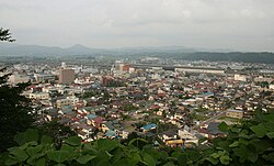 Ichinoseki Skyline | |
 Flag  Seal | |
Location of Ichinoseki in Iwate Prefecture | |
 Ichinoseki | |
| Coordinates: 38°56′5″N 141°07′35.7″E / 38.93472°N 141.126583°E | |
| Country | Japan |
| Region | Tōhoku |
| Prefecture | Iwate |
| Area | |
| • Total | 1,256.42 km2 (485.11 sq mi) |
| Population (May 1, 2020) | |
| • Total | 114,476 |
| • Density | 91/km2 (240/sq mi) |
| Time zone | Japan Standard Time |
| Phone number | 0191-21-2111 |
| Address | 7-2 Takeyama-chō, Ichinoseki-shi, Iwate-ken 021-8501 |
| Climate | Cfa |
| Website | Official website |
| Symbols | |
| Bird | Japanese bush-warbler |
| Flower | Canola |
| Tree | Japanese beech |

Geography edit
Ichinoseki is located inland in the south of Iwate Prefecture, a little over two hours north of Tokyo by the Tōhoku Shinkansen. A large volume of extremely stable granite rock runs beneath the city, and is the center of the site is being promoted as a suitable location for construction of the International Linear Collider (ILC).[2]
Neighboring municipalities edit
Iwate Prefecture
Miyagi Prefecture
Akita Prefecture
Climate edit
Ichinoseki has a humid climate (Köppen climate classification Cfa) with warm summers and cold winters. The average annual temperature in Ichinoseki is 10.9 °C. The average annual rainfall is 1248 mm with September as the wettest month and January as the driest month. The temperatures are highest on average in August, at around 24.3 °C, and lowest in January, at around -1.5 °C.[3]
| Climate data for Ichinoseki (1991−2020 normals, extremes 1976−present) | |||||||||||||
|---|---|---|---|---|---|---|---|---|---|---|---|---|---|
| Month | Jan | Feb | Mar | Apr | May | Jun | Jul | Aug | Sep | Oct | Nov | Dec | Year |
| Record high °C (°F) | 13.6 (56.5) |
17.3 (63.1) |
23.9 (75.0) |
31.4 (88.5) |
33.8 (92.8) |
34.5 (94.1) |
38.0 (100.4) |
38.2 (100.8) |
35.3 (95.5) |
29.1 (84.4) |
23.0 (73.4) |
21.4 (70.5) |
38.2 (100.8) |
| Mean daily maximum °C (°F) | 3.8 (38.8) |
5.1 (41.2) |
9.5 (49.1) |
16.0 (60.8) |
21.5 (70.7) |
24.7 (76.5) |
27.9 (82.2) |
29.3 (84.7) |
25.3 (77.5) |
19.3 (66.7) |
12.7 (54.9) |
6.1 (43.0) |
16.8 (62.2) |
| Daily mean °C (°F) | −0.1 (31.8) |
0.6 (33.1) |
4.1 (39.4) |
9.8 (49.6) |
15.4 (59.7) |
19.4 (66.9) |
23.0 (73.4) |
24.2 (75.6) |
20.4 (68.7) |
14.0 (57.2) |
7.6 (45.7) |
2.1 (35.8) |
11.7 (53.1) |
| Mean daily minimum °C (°F) | −3.6 (25.5) |
−3.3 (26.1) |
−0.8 (30.6) |
4.0 (39.2) |
10.1 (50.2) |
15.2 (59.4) |
19.4 (66.9) |
20.6 (69.1) |
16.5 (61.7) |
9.5 (49.1) |
3.0 (37.4) |
−1.4 (29.5) |
7.4 (45.4) |
| Record low °C (°F) | −14.4 (6.1) |
−15.2 (4.6) |
−10.3 (13.5) |
−4.6 (23.7) |
1.0 (33.8) |
5.3 (41.5) |
6.3 (43.3) |
11.6 (52.9) |
6.0 (42.8) |
−0.9 (30.4) |
−7.3 (18.9) |
−12.6 (9.3) |
−15.2 (4.6) |
| Average precipitation mm (inches) | 46.5 (1.83) |
40.1 (1.58) |
76.1 (3.00) |
86.6 (3.41) |
107.5 (4.23) |
121.8 (4.80) |
181.1 (7.13) |
161.9 (6.37) |
156.3 (6.15) |
118.6 (4.67) |
68.2 (2.69) |
58.7 (2.31) |
1,211.6 (47.70) |
| Average snowfall cm (inches) | 57 (22) |
52 (20) |
15 (5.9) |
2 (0.8) |
0 (0) |
0 (0) |
0 (0) |
0 (0) |
0 (0) |
0 (0) |
3 (1.2) |
40 (16) |
166 (65) |
| Average rainy days | 9.7 | 8.7 | 9.6 | 9.0 | 10.0 | 10.1 | 13.0 | 11.6 | 11.1 | 9.7 | 8.9 | 10.6 | 122 |
| Average snowy days | 7.2 | 6.1 | 1.8 | 0.3 | 0 | 0 | 0 | 0 | 0 | 0 | 0.2 | 4.4 | 20 |
| Mean monthly sunshine hours | 115.6 | 124.4 | 163.0 | 178.0 | 183.8 | 138.3 | 117.7 | 132.6 | 117.7 | 131.9 | 125.5 | 108.7 | 1,643.5 |
| Source 1: JMA[4] | |||||||||||||
| Source 2: JMA[5] | |||||||||||||
Demographics edit
The agricultural makeup of the city outside the centre is mostly composed of farmers, leading to an influx of Chinese and Filipino immigrants due to marriage. As a result, Ichinoseki has a varied ethnic makeup, although the newcomers still remain a small minority.
Per Japanese census data,[6] the population of Ichinoseki peaked in the 1950s and has declined over the past 70 years. Ichinoseki has been recognized by Japan's Office for the Promotion of Regional Revitalization (Kishida Cabinet Secretariat), which promotes the development of new technologies to combat depopulation, for meeting a "high standard" of digital transformation/telework infrastructure. Related projects have been awarded over ¥80M in government grants.[7]
| Year | Pop. | ±% |
|---|---|---|
| 1920 | 118,556 | — |
| 1930 | 131,447 | +10.9% |
| 1940 | 135,612 | +3.2% |
| 1950 | 170,515 | +25.7% |
| 1960 | 168,768 | −1.0% |
| 1970 | 150,366 | −10.9% |
| 1980 | 147,465 | −1.9% |
| 1990 | 144,896 | −1.7% |
| 2000 | 140,825 | −2.8% |
| 2010 | 127,642 | −9.4% |
| 2020 | 111,932 | −12.3% |
History edit
The area of present-day Ichinoseki was part of ancient Mutsu Province, and has been settled since at least the Japanese Paleolithic period. The area was inhabited by the Emishi people, and came under the control of the Yamato dynasty during the early Heian period. During the Heian period, it was controlled by the Abe clan, followed by the Northern Fujiwara clan of Hiraizumi. During the Sengoku period, the area was dominated by various samurai clans before coming under the control of the Date clan during the Edo period, who ruled Sendai Domain under the Tokugawa shogunate. A portion of the present city was part of Ichinoseki Domain, a sub-domain of Sendai Domain.
The town of Ichinoseki was established within Nishiiwai District, Iwate on April 1, 1889 with the establishment of the modern municipality system. It was raised to city status on April 1, 1948 by the merger of the towns of Ichinoseki and Yamame with the villages of Mataki and Nakasato.
- January 1, 1955 - Ichinoseki absorbed the villages of Genbi, Hagisho, Maikawa, and Yasakae
- September 1, 1956 - Due to a boundary adjustment, the city absorbed parts of the town of Hiraizumi.
- May 1, 1964 - Due to a boundary adjustment, the city absorbed more of the town of Hiraizumi.
- September 20, 2005 - the towns of Daitō, Higashiyama and Senmaya, the villages of Kawasaki and Murone (all from Higashiiwai District), and the town of Hanaizumi (from Nishiiwai District) were merged with the city of Ichinoseki, which approximately doubled the old city's population and nearly tripled its size.
- September 26, 2011 - the town of Fujisawa (also from Higashiiwai District) was merged into Ichinoseki. Higashiiwai District was dissolved as a result of this merger.
Government edit
Ichinoseki has a mayor-council form of government with a directly elected mayor and a unicameral city council of 25 members.[8] Ichinoseki and the town of Hiraizumi collectively contribute five seats to the Iwate Prefectural legislature. In terms of national politics, the city is part of Iwate 3rd district of the lower house of the Diet of Japan.
Education edit
Ichinoseki has 29 public elementary schools and 16 public junior high schools operated by the city government and one junior high school and eight public elementary schools operated by the Iwate Prefectural Board of Education. There is also one private high school and one private junior college. The Prefecture also operates one special education school for the handicapped.
Extended content
| |||||
|---|---|---|---|---|---|
Special school edit
Elementary schools edit
Junior high schools edit
High schools edit
Kosen edit
|
Junior college edit
Transportation edit
Railway edit
![]() East Japan Railway Company (JR East) - Tōhoku Shinkansen
East Japan Railway Company (JR East) - Tōhoku Shinkansen
![]() East Japan Railway Company (JR East) - Tōhoku Main Line
East Japan Railway Company (JR East) - Tōhoku Main Line
- Yushima - Hanaizumi - Shimizuhara - (Arikabe) - Ichinoseki - Yamanome
![]() East Japan Railway Company (JR East) - Ōfunato Line
East Japan Railway Company (JR East) - Ōfunato Line
- Ichinoseki - Mataki - Rikuchū-Kanzaki - Iwanoshita- Rikuchū-Matsukawa - Geibikei - Shibajuku - Surisawa - Senmaya - Konashi - Yagoshi - Orikabe - Niitsuki
Highway edit
Local attractions edit

- Ichinoseki is in close proximity to the historically significant site of Hiraizumi, which lies adjacent to the mid-northern border of the city. Ichinoseki station is a convenient transit hub for excursions to Hiraizumi, with access to Tōhoku Shinkansen and local rail lines.
- Geibikei is a dramatic river gorge which offers rides in traditional flat-bottomed boats, navigated by singing "gondoliers".
- Genbikei is another popular river area with naturally carved cliffs.
- Honederamura Shōen ruins has been designated an Important Cultural Landscape and a National Historic Site.[9] A brochure can be seen here. http://www.ichitabi.jp/guidebook/pdf/guidebook_04_03_en.pdf
Sister Cities/Friendship Cities edit
International relations edit
Friendship Cities edit
- Miharu (Tamura District, Fukushima Prefecture)
- Signed between the former city of Ichinoseki on August 8, 1987
- Kesennuma (Miyagi Prefecture)
- Signed between the former cities of Ichinoseki and Kesennuma on May 1, 1997
- Signed between the former city of Kesennuma and former town of Murone on May 8, 2003
- Tanabe (Wakayama Prefecture)
- Signed between the former village of Murone and the town of Hongu on August 8, 1987
- Yoshikawa (Saitama Prefecture)
- Signed by the former village of Murone on April 15, 1997
Notable people from Ichinoseki edit
- Ayaka Komatsu, model/actress
- Keiko Fuji, singer/actress
- Shota Kimura, baseball player
- Miyagiyama Fukumatsu, sumo wrestler
- Masato Onodera, professional wrestler
- Shota Onodera, basketball player
- Takahira Kogorō, diplomat
- Yuumi Shida, model/actress
References edit
- ^ Ichinoseki City official statistics (in Japanese)
- ^ http://www.city.ichinoseki.iwate.jp/ilc/en/index.html Ichinoseki City's ILC website
- ^ Ichinoseki climate data
- ^ 観測史上1~10位の値(年間を通じての値). JMA. Retrieved February 19, 2022.
- ^ 気象庁 / 平年値(年・月ごとの値). JMA. Retrieved February 19, 2022.
- ^ Ichinoseki population statistics
- ^ ''地方創生テレワーク交付金の交付対象事業一覧(新規事業)''. 内閣府地方創生推進室, 2021, p. 26
- ^ Hiraizumi Town Council
- ^ "Database of Registered National Cultural Properties". Agency for Cultural Affairs. Retrieved 29 April 2011.
- ^ "International Exchange". List of Affiliation Partners within Prefectures. Council of Local Authorities for International Relations (CLAIR). Archived from the original on 22 December 2015. Retrieved 21 November 2015.
External links edit
![]() Media related to Ichinoseki, Iwate at Wikimedia Commons
Media related to Ichinoseki, Iwate at Wikimedia Commons
- Official website
 (in Japanese)
 - Ichinoseki tourist information