
KNOWPIA
WELCOME TO KNOWPIA

Ivry-la-Bataille 
Summary
Ivry-la-Bataille (French pronunciation: [ivʁi la bataj]) is a commune in the Eure Department in the Normandy region in northern France. Ivry-la-Bataille was formerly known as Ivry.
Ivry-la-Bataille | |
|---|---|
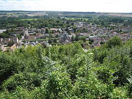 The village seen from the chateau | |
 Flag  Coat of arms | |
Location of Ivry-la-Bataille .mw-parser-output .locmap .od{position:absolute}.mw-parser-output .locmap .id{position:absolute;line-height:0}.mw-parser-output .locmap .l0{font-size:0;position:absolute}.mw-parser-output .locmap .pv{line-height:110%;position:absolute;text-align:center}.mw-parser-output .locmap .pl{line-height:110%;position:absolute;top:-0.75em;text-align:right}.mw-parser-output .locmap .pr{line-height:110%;position:absolute;top:-0.75em;text-align:left}.mw-parser-output .locmap .pv>div{display:inline;padding:1px}.mw-parser-output .locmap .pl>div{display:inline;padding:1px;float:right}.mw-parser-output .locmap .pr>div{display:inline;padding:1px;float:left}html.skin-theme-clientpref-night .mw-parser-output .od,html.skin-theme-clientpref-night .mw-parser-output .od .pv>div,html.skin-theme-clientpref-night .mw-parser-output .od .pl>div,html.skin-theme-clientpref-night .mw-parser-output .od .pr>div{background:#000;color:#fff}html.skin-theme-clientpref-night .mw-parser-output .locmap{filter:grayscale(0.6)}@media(prefers-color-scheme:dark){html.skin-theme-clientpref-os .mw-parser-output .locmap{filter:grayscale(0.6)}html.skin-theme-clientpref-os .mw-parser-output .od,html.skin-theme-clientpref-os .mw-parser-output .od .pv>div,html.skin-theme-clientpref-os .mw-parser-output .od .pl>div,html.skin-theme-clientpref-os .mw-parser-output .od .pr>div{background:#000;color:#fff}}  Ivry-la-Bataille  Ivry-la-Bataille | |
| Coordinates: 48°53′04″N 1°27′42″E / 48.8844°N 1.4617°E | |
| Country | France |
| Region | Normandy |
| Department | Eure |
| Arrondissement | Évreux |
| Canton | Saint-André-de-l'Eure |
| Intercommunality | CA Pays de Dreux |
| Government | |
| • Mayor (2020–2026) | Sylvie Hénaux[1] |
| Area 1 | 7.76 km2 (3.00 sq mi) |
| Population (2021)[2] | 2,638 |
| • Density | 340/km2 (880/sq mi) |
| Time zone | UTC+01:00 (CET) |
| • Summer (DST) | UTC+02:00 (CEST) |
| INSEE/Postal code | 27355 /27540 |
| Elevation | 55–137 m (180–449 ft) (avg. 64 m or 210 ft) |
| 1 French Land Register data, which excludes lakes, ponds, glaciers > 1 km2 (0.386 sq mi or 247 acres) and river estuaries. | |
History edit
King Henry IV of France won the Battle of Ivry near Ivry on 14 March 1590. The place was renamed Ivry-la-Bataille (Ivry-the-Battle) to commemorate the battle and to distinguish the town from Ivry-sur-Seine.
Geography edit
Ivry-la-Bataille is located on the river Eure in Normandy and about thirty miles (50 km) west of Paris, at the boundary between the Île-de-France and the Beauce regions.
Population edit
| Year | Pop. | ±% p.a. |
|---|---|---|
| 1968 | 2,183 | — |
| 1975 | 2,335 | +0.97% |
| 1982 | 2,065 | −1.74% |
| 1990 | 2,563 | +2.74% |
| 1999 | 2,639 | +0.33% |
| 2007 | 2,640 | +0.00% |
| 2012 | 2,611 | −0.22% |
| 2017 | 2,724 | +0.85% |
| Source: INSEE[3] | ||
Sights edit
See also edit
References edit
- ^ "Répertoire national des élus: les maires" (in French). data.gouv.fr, Plateforme ouverte des données publiques françaises. 13 September 2022.
- ^ "Populations légales 2021". The National Institute of Statistics and Economic Studies. 28 December 2023.
- ^ Population en historique depuis 1968, INSEE
External links edit
Wikimedia Commons has media related to Ivry-la-Bataille.
- Official Web site