
-
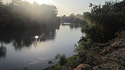 Alazani
 -
 Aragvi River
 -
 Çoruh River
 -
 Enguri River
 -
 Kura River
 -
 Rioni River

KNOWPIA
WELCOME TO KNOWPIA
List of rivers of Georgia (country) 
Summary
The rivers of Georgia, a country in the Caucasus, are part of either the Black Sea or Caspian Sea Drainage basins. The most spectacular rivers include the Alazani (longest river flowing through Georgia and Azerbaijan), Aragvi, Enguri (second longest river within Georgia), Kura (Mtkvari), and Rioni (longest river in Georgia) rivers.[1]
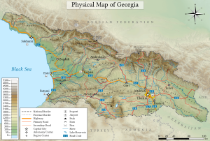
Georgia has about 25,000 rivers, many of which power small hydroelectric stations. Drainage is into the Black Sea to the west and through Azerbaijan to the Caspian Sea to the east. The largest river is the Kura River, which flows 1,364 km from northeast Turkey across the plains of eastern Georgia, through the capital, Tbilisi, and into the Caspian Sea. The Rioni River, the largest river in western Georgia, rises in the Greater Caucasus and empties into the Black Sea at the port of Poti. Soviet engineers turned the river lowlands along the Black Sea coast into prime subtropical agricultural land, embanked and straightened many stretches of river, and built an extensive system of canals. Deep mountain gorges form topographical belts within the Greater Caucasus.[2]
List of rivers edit
The following table lists significant rivers that flow through Georgia. It shows the total length of the river, the length of the river within Georgia and other countries the river flows through, the size of the river's drainage basin, and the course of the river to the Caspian Sea or Black Sea.
| River | Total length | Length within Georgia (Other countries) | Basin size, 1,000 | Course |
|---|---|---|---|---|
| Aapsta[3] | 35 km (22 mi) | 35 km (22 mi) (de facto Abkhazia) | .243 km2 (0.094 sq mi) | Black Sea |
| Abasha | 66 km (41 mi) | 66 km (41 mi) | .370 km2 (0.143 sq mi) | Black Sea |
| Acharistsqali | 90 km (56 mi) | 90 km (56 mi) | 1.5 km2 (0.58 sq mi) | Black Sea, Chorokhi→ |
| Alazani | 409 km (254 mi) | 391 km (243 mi) (Azerbaijan) | 22.0 km2 (8.5 sq mi) | Caspian Sea |
| Algeti | 108 km (67 mi) | 108 km (67 mi) | .763 km2 (0.295 sq mi) | Caspian Sea |
| Amtkeli | 38 km (24 mi) | 38 km (24 mi) | .398 km2 (0.154 sq mi) | Black Sea, Kodori→ |
| Andi Koysu | 144 km (89 mi) | (Russia) | 4.81 km2 (1.86 sq mi) | Caspian Sea, Sulak→ |
| Aragvi | 110 km (68 mi) | 110 km (68 mi) | 2.7 km2 (1.0 sq mi) | Caspian Sea, Kura→ |
| Argun | 148 km (92 mi) | (Russia) | 3.39 km2 (1.31 sq mi) | Caspian Sea, Sunzha→ Terek→ |
| Assa | 133 km (83 mi) | (Russia) | 2.06 km2 (0.80 sq mi) | Caspian Sea, Sunzha→ Terek→ |
| Bakhvistsqali | 42 km (26 mi) | 42 km (26 mi) | .156 km2 (0.060 sq mi) | Black Sea, Supsa→ |
| Bzyb (Bzipi)[3] | 110 km (68 mi) | 110 km (68 mi) | 1.5 km2 (0.58 sq mi) | Black sea |
| Chanistsqali | 63 km (39 mi) | 63 km (39 mi) | .315 km2 (0.122 sq mi) | Black Sea, Khobi→ |
| Choloki | 29.5 km (18.3 mi) | 29.5 km (18.3 mi) | .159 km2 (0.061 sq mi) | Black Sea, Natenbi→ |
| Çoruh (Chorokhi) | 438 km (272 mi) | 26 km (16 mi) (Turkey) | 22.1 km2 (8.5 sq mi)[4] | Black sea |
| Debed | 176 km (109 mi) | (Armenia) | 4.08 km2 (1.58 sq mi) | Caspian Sea, Khrami→ Kura→ |
| Dzirula | 83 km (52 mi) | 83 km (52 mi) | 1.27 km2 (0.49 sq mi) | Black Sea, Qvirila→ Rioni→ |
| Enguri | 206 km (128 mi) | 206 km (128 mi) | 4.1 km2 (1.6 sq mi) | Black sea |
| Ghalidzga[3] | 53 km (33 mi) | 53 km (33 mi) (de facto Abkhazia) | .483 km2 (0.186 sq mi) | Black Sea |
| Great Liakhvi | 115 km (71 mi) | 115 km (71 mi) | 2.311 km2 (0.892 sq mi) | Caspian Sea, Kura→ |
| Gumista River[3] | 12 km (7.5 mi) | 12 km (7.5 mi) (de facto Abkhazia) | .576 km2 (0.222 sq mi) | Black Sea |
| Iori | 320 km (200 mi) | 183 km (114 mi) (Azerbaijan) | 4.7 km2 (1.8 sq mi) | Caspian Sea |
| Kelasuri[3] | 42 km (26 mi) | 42 km (26 mi) (de facto Abkhazia) | .22 km2 (0.085 sq mi) | Black Sea |
| Khanistsqali | 57 km (35 mi) | 57 km (35 mi) | .914 km2 (0.353 sq mi) | Black Sea, Rioni→ |
| Khipsta | 33 km (21 mi) | 33 km (21 mi) | 0 km2 (0 sq mi) | Black Sea |
| Khobi | 150 km (93 mi) | 150 km (93 mi) | 1.34 km2 (0.52 sq mi) | Black Sea |
| Khrami | 220 km (140 mi) | 187 km (116 mi) (Azerbaijan) | 8.3 km2 (3.2 sq mi) | Caspian Sea |
| Kintrishi[5] | 45 km (28 mi) | 45 km (28 mi) | .291 km2 (0.112 sq mi) | Black Sea |
| Kodori[3] | 110 km (68 mi) | 110 km (68 mi) | 2.0 km2 (0.77 sq mi) | Black sea |
| Korolistskali | 29.5 km (18.3 mi) | 29.5 km (18.3 mi) | .159 km2 (0.061 sq mi) | Black Sea |
| Ksani | 84 km (52 mi) | 84 km (52 mi) | .885 km2 (0.342 sq mi) | Caspian Sea, Kura→ |
| Kura (Mtkvari) | 1,515 km (941 mi) | 351 km (218 mi) (Turkey, Azerbaijan) | 21.1 km2 (8.1 sq mi) | Caspian Sea |
| Kvabliani | 41 km (25 mi) | 41 km (25 mi) | .9 km2 (0.35 sq mi) | Caspian Sea |
| Little Liakhvi | 63 km (39 mi) | 63 km (39 mi) | .513 km2 (0.198 sq mi) | Caspian Sea, Great Liakhvi→ Kura→ |
| Lopota | 33 km (21 mi) | 33 km (21 mi) | .263 km2 (0.102 sq mi) | Caspian Sea, Alazani→ Kura→ |
| Machakhelistsqali | 37 km (23 mi) | (Turkey) | 369 km2 (142 sq mi) | Black Sea, Çoruh→ |
| Mashavera | 66 km (41 mi) | 66 km (41 mi) | 1.39 km2 (0.54 sq mi) | Caspian Sea, Khrami→ Kura→ |
| Mokvi | 47 km (29 mi) | 47 km (29 mi) | .336 km2 (0.130 sq mi) | Black Sea |
| Mulkhra | 27 km (17 mi) | 27 km (17 mi) | .435 km2 (0.168 sq mi) | Black Sea, Enguri→ |
| Natanebi | 60 km (37 mi) | 60 km (37 mi) | .657 km2 (0.254 sq mi) | Black Sea |
| Ochkhamuri | 21.4 km (13.3 mi) | 21.4 km (13.3 mi) | .0652 km2 (0.0252 sq mi) | Black Sea, Choloki→ Natanebi→ |
| Paravani | 74 km (46 mi) | 74 km (46 mi) | 2.35 km2 (0.91 sq mi) | Caspian Sea, Kura→ |
| Pkhista[3] | 13 km (8.1 mi) | 13 km (8.1 mi) (de facto Abkhazia) | Black Sea, Pkhista→ Psou→ | |
| Psou[3] | 57 km (35 mi) | 57 km (35 mi) (de facto Abkhazia, along Russian Border) |
.420 km2 (0.162 sq mi) | Black Sea |
| Qvirila (Kvrilia) | 152 km (94 mi) | 152 km (94 mi) | 3.6 km2 (1.4 sq mi) | Black Sea, Rioni River→ |
| Rioni | 333 km (207 mi) | 333 km (207 mi) | 13.4 km2 (5.2 sq mi) | Black sea |
| Supsa | 117 km (73 mi) | 117 km (73 mi) | 1.1 km2 (0.42 sq mi) | Black sea |
| Suramula | 42 km (26 mi) | 42 km (26 mi) | .719 km2 (0.278 sq mi) | Caspian Sea, Ptsa→ Kura→ |
| Tedzami | 51 km (32 mi) | 51 km (32 mi) | .404 km2 (0.156 sq mi) | Caspian Sea, Kura→ |
| Tekhuri | 101 km (63 mi) | 101 km (63 mi) | 1.04 km2 (0.40 sq mi) | Black Sea, Rioni→ |
| Terek (Tergi) | 623 km (387 mi) | (Russia) | 43.2 km2 (16.7 sq mi) | Caspian Sea |
| Tskhenistsqali | 184 km (114 mi) | 184 km (114 mi) | 2.1 km2 (0.81 sq mi) | Black Sea, Rioni River→ |
| Vere | 45 km (28 mi) | 45 km (28 mi) | .194 km2 (0.075 sq mi) | Caspian Sea, Kura→ |
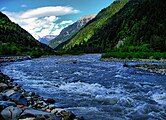
Pictures of rivers edit
Spectacular Georgian rivers


References edit
- ^ "Five most spectacular rivers of Georgia". Georgia Journal. April 23, 2015. Retrieved June 11, 2021.
- ^ Curtis, Glenn E. (1995). Armenia, Azerbaijan, and Georgia : country studies (1st ed.). Washington, D.C.: Federal Research Division. pp. 175–177. ISBN 0-8444-0848-4. OCLC 31709972.
 This article incorporates text from this source, which is in the public domain.
{{cite book}}: CS1 maint: postscript (link) - ^ a b c d e f g h Flows through Abkhazia autonomous region of Georgia.
- ^ Ministry of Economic Development of Georgia. Department of Statistics (Tbilisi, 2008), Statistical Yearbook of Georgia: 2007, p. 12.
- ^ The Kintrishi River flows through the Autonomous Region of Adjara.
- Tielidze, Levan, ed. (2019). Geomorphology of Georgia. Springer. ISBN 9783319777641. Retrieved June 11, 2021.
- Country Profile - Georgia (PDF). Food and Agricultural Organization of the United Nations. 2008. Retrieved June 11, 2021.
- Tielidze, Levan, ed. (1987). Orthographic Dictionary of Geographical Names of the Georgian SSR. Georgian Soviet Encyclopedia.