


Summary
Luing (/ˈlɪŋ/ LING; Scottish Gaelic: Luinn) is one of the Slate Islands, Firth of Lorn, in the west of Argyll in Scotland, about 16 miles (26 km) south of Oban. The island has an area of 1,430 hectares (3,500 acres) and is bounded by several small skerries and islets. It has a population of around 200 people, mostly living in Cullipool, Toberonochy (Tobar Dhonnchaidh), and Blackmillbay.[6]
| Scottish Gaelic name | Luinn |
|---|---|
| Meaning of name | pre-Gaelic name of unclear meaning |
 View from near Toberonochy, Luing | |
| Location | |
 Luing Luing shown within Argyll and Bute | |
| OS grid reference | NM740100 |
| Coordinates | 56°13′42″N 5°38′28″W / 56.22829819°N 5.64124049°W |
| Physical geography | |
| Island group | Slate Islands |
| Area | 1,430 ha (5+1⁄2 sq mi) |
| Area rank | 40 [1] |
| Highest elevation | Binneinn Furachail, 87 m (285 ft) |
| Administration | |
| Sovereign state | United Kingdom |
| Country | Scotland |
| Council area | Argyll and Bute |
| Demographics | |
| Population | 195[2] |
| Population rank | 32= [1] |
| Population density | 12.6/km2 (33/sq mi) |
| Largest settlement | Cullipool/Culapul |
| References | [3][4] [5] |
Geology edit
The larger part of the bedrock of Luing is provided by the Neoproterozoic age Easdale Slate Formation, a pyritic, graphitic pelite belonging to the Easdale Subgroup of the Dalradian Argyll Group. Thin bands of quartzite are also present. Zones of metamorphosed intrusive igneous rocks occur within the northeast of the island. Luing is cut by NE-SW aligned Siluro-Devonian felsite dykes and by numerous later NW-SE aligned basalt and microgabbro dykes which form a part of the ‘Mull Swarm’ which is of early Palaeogene age. Raised marine deposits of sand and gravel occur widely around the margins of the island, a legacy of late Quaternary changes in relative sea-level.[7][8]
Economy and culture edit
A regular ferry service crosses the 200-metre-wide (660-foot) Cuan Sound which separates Luing from the neighbouring island of Seil, which is in turn connected by bridge to the mainland.[6]
The main industries on Luing are tourism, lobster fishing and beef farming, although slate quarrying was important until 1965,[3] with quarries at Toberonochy, Cullipool, and a smaller one at Port Mary. Slate from Luing was used in the construction of the University of Glasgow and re-roofing of Iona Abbey.
For such a small island, Luing has produced numerous mòd gold medallists: Nan MacInnes (1926, in Oban), Sandy Brown (1938, in Glasgow) and Hughie MacQueen (1985, in Lochaber).
Luing cattle were first developed here, as a commercial beef breed hardy enough to prosper under adverse weather.[9] They are a breed of red beef cattle, produced by the Cadzow family in 1947 from a cross between Beef Shorthorn and Highland cattle.[10]
Etymology edit
According to Haswell-Smith (2004) the name "Luing" may derive from the Old Norse lyng, meaning "heather" or long meaning ship.[3] However, Mac an Tàilleir (2003) states "this is probably a pre-Gaelic name of unclear meaning."[5]
History edit
In the early part of the Christian era Luing would have formed part of the Gaelic kingdom of Dalriada. From the 9th to 13th centuries almost all of the Hebrides came under the control of Norse settlers and formed part of the Kingdom of the Isles. However, when Edgar of Scotland signed a treaty with Magnus Barefoot in 1098, formally acknowledged the existing situation by giving up Scottish claims to the Hebrides and Kintyre, Luing and Lismore were retained by the Scots.[11]
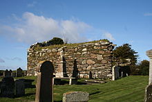
The graveyard at the ruined church of Kilchattan documents the lives of past islanders, with quarriers, sailors and crofters side by side. Gravestones of note include those of Covenanter Alexander Campbell.[12]
Footnotes edit
- ^ a b Area and population ranks: there are c. 300 islands over 20 ha in extent and 93 permanently inhabited islands were listed in the 2011 census.
- ^ National Records of Scotland (15 August 2013). "Appendix 2: Population and households on Scotland's Inhabited Islands" (PDF). Statistical Bulletin: 2011 Census: First Results on Population and Household Estimates for Scotland Release 1C (Part Two) (PDF) (Report). SG/2013/126. Retrieved 14 August 2020.
- ^ a b c Haswell-Smith (2004) p. 70
- ^ Ordnance Survey: Landranger map sheet 55 Lochgilphead & Loch Awe (Map). Ordnance Survey. 2011. ISBN 9780319231227.
- ^ a b Mac an Tàilleir (2003) p. 83
- ^ a b "Luing". Undiscovered Scotland. Retrieved 28 July 2007.
- ^ "Onshore Geoindex". British Geological Survey. British Geological Survey. Retrieved 5 February 2020.
- ^ "Kilmartin, Scotland sheet 36, Bedrock and Superficial deposits". BGS large map images. British Geological Survey. Retrieved 5 February 2020.
- ^ "Luing Cattle". Luing Cattle Society. Retrieved 28 July 2007.
- ^ "Overview of Luing". Gazetteer for Scotland. Retrieved 28 July 2007.
- ^ Sellar (2000) p. 191
- ^ "Luing: Heritage". Isle of Luing Website. Retrieved 28 July 2007.
References edit
- Haswell-Smith, Hamish (2004). The Scottish Islands. Edinburgh: Canongate. ISBN 978-1-84195-454-7.
- Mac an Tàilleir, Iain (2003) Ainmean-àite/Placenames. (pdf) Pàrlamaid na h-Alba. Retrieved 26 August 2012.
- Sellar, William David Hamilton (2000). "Hebridean sea kings: The successors of Somerled, 1164–1316". In Cowan, Edward J.; McDonald, Russell Andrew (eds.). Alba: Celtic Scotland in the middle ages. Tuckwell Press. ISBN 978-1-86232-151-9.
56°13′45″N 5°38′44″W / 56.22917°N 5.64556°W