


Summary
Muckle Skerry is the largest of the Pentland Skerries that lie off the north coast of Scotland. It is home to the Pentland Skerries Lighthouse.

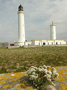 Pentland Skerries High and Low Lighthouses | |
 | |
| Location | Muckle Skerry Pentland Skerries Orkney Scotland United Kingdom |
|---|---|
| Coordinates | 58°41′25″N 2°55′29″W / 58.690221°N 2.924735°W |
| Tower | |
| Constructed | 1794 |
| Built by | Thomas Smith, Robert Stevenson |
| Construction | stone tower |
| Automated | 1994 |
| Height | 36 m (118 ft) |
| Shape | cylindrical tower with balcony and lantern |
| Markings | white tower, black lantern, ochre trim |
| Power source | solar power |
| Operator | Northern Lighthouse Board[1][2] |
| Light | |
| First lit | 1820s rebuilt |
| Focal height | 52 m (171 ft) |
| Intensity | 710,000 candela |
| Range | 23 nmi (43 km) |
| Characteristic | Fl (3) W 30 s |
Muckle Skerry lies in the Pentland Firth at grid reference ND464782. It is the westernmost of the skerries. At one kilometre (five furlongs) long and rising to an elevation of 20 metres (65 feet) above sea level, it is sizable enough to be considered an island. However the notoriously bad weather of the firth has historically rendered Muckle Skerry uninhabitable and as such it is more often thought of as a skerry.
Pentland Skerries Lighthouse edit
Pentland Skerries Lighthouse was constructed in 1794 by the Commissioners of the Northern Lights. The engineers were Thomas Smith and his stepson Robert Stevenson (this was the first light that Stevenson officially worked on).
See also edit
References edit
- ^ Rowlett, Russ. "Lighthouses of Scotland: Orkney". The Lighthouse Directory. University of North Carolina at Chapel Hill. Retrieved 26 May 2016.
- ^ Pentland Skerries Northern Lighthouse Board. Retrieved 26 May 2016
External links edit
- Pentland Skerries Northern Lighthouse Board
- Northern Lighthouse Board
58°41′18″N 2°55′35″W / 58.68824°N 2.92631°W