
KNOWPIA
WELCOME TO KNOWPIA

NR postcode area 
Summary
Wikimedia Commons has media related to Post boxes in NR postcode area.
Template:Attached KML/NR postcode area
KML is from Wikidata
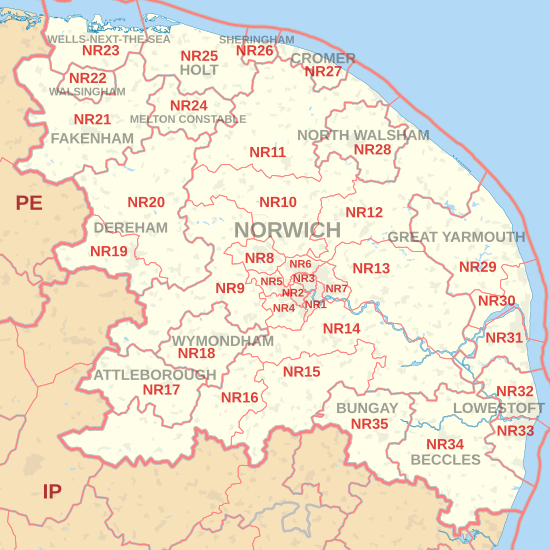
The NR postcode area, also known as the Norwich postcode area,[2] is a group of 35 postcode districts in the east of England, within 16 post towns. These cover central and eastern Norfolk (including Norwich, Great Yarmouth, Attleborough, Wymondham, Dereham, Fakenham, Walsingham, Wells-next-the-Sea, Melton Constable, Holt, Sheringham, Cromer and North Walsham) and part of north-east Suffolk (including Lowestoft, Beccles and Bungay).
Norwich | |
|---|---|
 NR | |
| Coordinates: 52°38′49″N 1°20′20″E / 52.647°N 1.339°E | |
| Country | United Kingdom |
| Postcode area | NR |
| Postcode area name | Norwich |
| Post towns | 16 |
| Postcode districts | 36 |
| Postcode sectors | 114 |
| Postcodes (live) | 23,457 |
| Postcodes (total) | 28,198 |
| Statistics as at May 2020[1] | |
Coverage edit
The approximate coverage of the postcode districts:
| Postcode district | Post town | Coverage | Local authority area(s) |
|---|---|---|---|
| NR1 | NORWICH | Thorpe Hamlet, Lakenham, (parts of) City Centre, areas close to Thorpe Road Mail Centre | Norwich |
| NR2 | NORWICH | Parts of Eaton, parts of Earlham, western and south-western parts of Norwich and parts of the city centre | Norwich |
| NR3 | NORWICH | N part of Norwich, within the ring-road: Mile Cross, New Catton | Norwich, Broadland |
| NR4 | NORWICH | Suburbs and villages W and SW of Norwich: Eaton, Tuckswood, Cringleford, Colney, Keswick | South Norfolk |
| NR5 | NORWICH | W and NW suburbs of Norwich: Bowthorpe, Costessey, Earlham | Norwich, South Norfolk |
| NR6 | NORWICH | N and NW suburbs of Norwich: Old Catton, Hellesdon | Norwich, Broadland |
| NR7 | NORWICH | E and SE suburbs of Norwich: Sprowston, Thorpe St. Andrew, Heartsease | Norwich, Broadland |
| NR8 | NORWICH | Suburbs and villages NW of Norwich: Drayton, Taverham, Ringland | Broadland, South Norfolk |
| NR9 | NORWICH | Villages W and NW of Norwich: Barford, Bawburgh, Hethersett, Honingham, Lenwade, Little Melton, Lyng, Marlingford and Colton, Weston Longville | Broadland, South Norfolk |
| NR10 | NORWICH | Villages and towns N and NW of Norwich: Pettywell, Reepham, Hevingham, Stratton Strawless, Horsham St Faith | Broadland, South Norfolk |
| NR11 | NORWICH | Alby with Thwaite, Aldborough, Aylmerton, Aylsham, Banningham, Blickling, East Beckham, Little Barningham, Hanworth, North Barningham, Roughton, Felbrigg, Gimingham, Ingworth, Matlask, Mundesley, Southrepps, Trimingham, Wickmere | North Norfolk, Broadland |
| NR12 | NORWICH | Bacton, Brumstead, Coltishall, East Ruston, Hickling, Ingham, Lessingham, Sloley, Stalham, Tunstead, Wroxham | North Norfolk |
| NR13 | NORWICH | Towns and villages E of Norwich: Acle, Brundall, Reedham, Rackheath, Salhouse | Broadland |
| NR14 | NORWICH | Suburbs and villages SE of Norwich: Loddon, Poringland, Trowse, Haddiscoe | South Norfolk |
| NR15 | NORWICH | Long Stratton, Hempnall, Tasburgh, Newton Flotman | South Norfolk |
| NR16 | NORWICH | Banham, Larling, New Buckenham | Breckland |
| NR17 | ATTLEBOROUGH | Attleborough, Little & Great Ellingham, Old Buckenham | Breckland |
| NR18 | NORWICH | non-geographic[3] | |
| NR18 | WYMONDHAM | Wymondham | South Norfolk |
| NR19 | NORWICH | non-geographic[4][5] | |
| NR19 | DEREHAM | Dereham | Breckland |
| NR20 | DEREHAM | Villages N and E of Dereham: Bawdeswell, Bylaugh, Elsing, Foxley, Foulsham, Gressenhall, Guestwick, Hockering, Mattishall, Whissonsett, Nethergate, North Elmham, Swanton Morley, Themelthorpe | Breckland |
| NR21 | FAKENHAM | Fakenham, Barsham, Binham, Fulmodeston, Colkirk, North Creake, South Creake, South Raynham, East Raynham, West Raynham, Hempton, Helhoughton, Hindringham, Tatterford, Toftrees | North Norfolk, King's Lynn and West Norfolk, Breckland |
| NR22 | WALSINGHAM | Walsingham, Houghton St Giles, North Barsham | North Norfolk, King's Lynn and West Norfolk |
| NR23 | WELLS-NEXT-THE-SEA | Wells-next-the-Sea, Quarles, Warham, Wighton | North Norfolk, King's Lynn and West Norfolk |
| NR24 | MELTON CONSTABLE | Melton Constable, Stody, Briston, Briningham, Brinton, Edgefield, Gunthorpe, Sharrington, Plumstead, Swanton Novers | North Norfolk |
| NR25 | HOLT | Holt, Kelling, Baconsthorpe, Blakeney, Bodham, Cley next the Sea, Edgfield, Hempstead, High Kelling, Hunworth Langham, Letheringsett, Glandford, Weybourne, West Beckham, Salthouse | North Norfolk |
| NR26 | NORWICH | non-geographic[3] | |
| NR26 | SHERINGHAM | Sheringham, Beeston Regis, Upper Sheringham | North Norfolk |
| NR27 | CROMER | Cromer, East Runton, West Runton, Frogshall, Northrepps, Overstrand | North Norfolk |
| NR28 | NORTH WALSHAM | North Walsham, Antingham, Crostwight, Honing, Knapton, Trunch, Paston, Ridlington | North Norfolk |
| NR29 | GREAT YARMOUTH | Catfield, Hemsby, Potter Heigham, Rollesby | Great Yarmouth, North Norfolk |
| NR30 | GREAT YARMOUTH | Great Yarmouth, Caister-on-Sea, West Caister | Great Yarmouth |
| NR31 | GREAT YARMOUTH | Gorleston-on-Sea, Bradwell | Great Yarmouth |
| NR32 | LOWESTOFT | North Lowestoft | East Suffolk |
| NR33 | LOWESTOFT | South Lowestoft | East Suffolk |
| NR34 | BECCLES | Beccles, Worlingham, Gillingham, Stockton | East Suffolk, South Norfolk |
| NR35 | BUNGAY | Bungay, Topcroft, Flixton | East Suffolk, South Norfolk |
| NR99 | NORWICH | non-geographic[4] |
Map edit
Template:Attached KML/NR postcode area
KML is from Wikidata
See also edit
References edit
- ^ "ONS Postcode Directory Version Notes" (ZIP). National Statistics Postcode Products. Office for National Statistics. May 2020. Table 2. Retrieved 19 June 2020. Coordinates from mean of unit postcode points, "Code-Point Open". OS OpenData. Ordnance Survey. February 2012. Retrieved 21 April 2012.
- ^ Royal Mail, Address Management Guide, (2004)
- ^ a b "New sectors and localities to 16 November 2012" (PDF). Royal Mail Address Management Unit. 19 November 2012. Retrieved 29 November 2012.[permanent dead link]
- ^ a b "Non Geographic Codes" (PDF). Royal Mail Address Management Unit. July 2012. Archived from the original (PDF) on 16 September 2012. Retrieved 20 December 2012.
- ^ "New sectors and localities to 14 December 2012" (PDF). Royal Mail Address Management Unit. 20 December 2012. Archived from the original (PDF) on 2 February 2015. Retrieved 20 December 2012.
External links edit
- Royal Mail's Postcode Address File
- A quick introduction to Royal Mail's Postcode Address File (PAF)