


Summary
North Terrace is one of the four terraces that bound the central business and residential district of Adelaide, the capital city of South Australia. It runs east–west, along the northern edge of "the square mile". The western end continues on to Port Road, and the eastern end continues across the Adelaide Parklands as Botanic Road.[2][3]
North Terrace | |
|---|---|
 | |
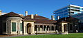
| North Terrace facing west in the early evening | |
.mw-parser-output .locmap .od{position:absolute}.mw-parser-output .locmap .id{position:absolute;line-height:0}.mw-parser-output .locmap .l0{font-size:0;position:absolute}.mw-parser-output .locmap .pv{line-height:110%;position:absolute;text-align:center}.mw-parser-output .locmap .pl{line-height:110%;position:absolute;top:-0.75em;text-align:right}.mw-parser-output .locmap .pr{line-height:110%;position:absolute;top:-0.75em;text-align:left}.mw-parser-output .locmap .pv>div{display:inline;padding:1px}.mw-parser-output .locmap .pl>div{display:inline;padding:1px;float:right}.mw-parser-output .locmap .pr>div{display:inline;padding:1px;float:left}html.skin-theme-clientpref-night .mw-parser-output .od,html.skin-theme-clientpref-night .mw-parser-output .od .pv>div,html.skin-theme-clientpref-night .mw-parser-output .od .pl>div,html.skin-theme-clientpref-night .mw-parser-output .od .pr>div{background:#000;color:#fff}html.skin-theme-clientpref-night .mw-parser-output .locmap{filter:grayscale(0.6)}@media(prefers-color-scheme:dark){html.skin-theme-clientpref-os .mw-parser-output .locmap{filter:grayscale(0.6)}html.skin-theme-clientpref-os .mw-parser-output .od,html.skin-theme-clientpref-os .mw-parser-output .od .pv>div,html.skin-theme-clientpref-os .mw-parser-output .od .pl>div,html.skin-theme-clientpref-os .mw-parser-output .od .pr>div{background:#000;color:#fff}} West end East end | |
| Coordinates |
|
| General information | |
| Type | Street |
| Location | Adelaide city centre |
| Length | 2.1 km (1.3 mi)[1] |
| Opened | 1837 |
| Major junctions | |
| West end | West Terrace Port Road Adelaide |
| East end | East Terrace Botanic Road Adelaide |
| Location(s) | |
| LGA(s) | City of Adelaide |


North side of North Terrace edit
Theoretically, the northern side of North Terrace is part of the Adelaide Parklands. However, much of the space between North Terrace and the River Torrens is occupied by cultural institutions and other public buildings. Starting from West Terrace and travelling east, these buildings include:
- Parkland
- Royal Adelaide Hospital
- South Australian Health and Medical Research Institute (SAHMRI)
- Adelaide Medical and Nursing Schools (University of Adelaide)
- University of South Australia Cancer Research Institute (previously the site of City Sk8 Park, a skateboarding facility)
(Morphett Street bridge)
- Adelaide Convention Centre, Exhibition Halls (partly above the railway station platforms)
- Riverside Centre (above the railway station platforms)
- InterContinental Hotel (formerly the Hyatt Regency until 2009[4] Public art around the hotel includes:
- Adelaide railway station building
- Adelaide Casino (inside the historic station building)
- Old Parliament House - the original South Australian Parliament building
- Parliament House
- The Adelaide Festival Centre and Elder Park are behind Parliament House, between North Terrace and the River Torrens – also accessible from King William Road
- Government House, the official residence of the governor of South Australia
- The historic Torrens Parade Ground is behind Government House, between North Terrace and the River Torrens – accessible from King William Road
- The South African War Memorial stands in front of Government House on a traffic island at the corner of North Terrace and King William Road
- The Jubilee 150 Walkway commences in front of Government House
- National War Memorial
(Kintore Avenue)
- State Library of South Australia
- Institute Building (1859)
- Spence Wing
- Mortlock Wing (1884)
- South Australian Museum
- Art Gallery of South Australia
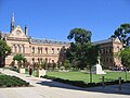
- University of Adelaide (original campus, now called the North Terrace campus):
- Mitchell Building
- Elder Conservatorium of Music
- Bonython Hall[9]
- Napier Building
- Ligertwood Building
- The Jubilee 150 Walkway finishes in front of the Napier/Ligertwood plaza.
- University of South Australia (originally the South Australian School of Mines and Industries/Adelaide Technical High School, now called the City East campus)
- Adelaide Botanic Gardens
- National Wine Centre of Australia
South side of North Terrace edit
Starting at West Terrace and travelling east, the southern side of the street includes:
- The Newmarket Hotel
- Assorted accommodation, businesses and medical practices
- Many buildings forming the City West campus of the University of South Australia
- The Lion Arts Centre (in the old Fowler's Lion Flour Factory building)
(Morphett Street bridge)
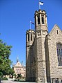
- The historic Holy Trinity Church (Anglican)
- Assorted accommodation, including the Stamford Plaza and Grosvenor Hotels, and Oaks Adelaide Embassy suites[10]
- Various businesses and government offices
- The Dame Roma Mitchell building
- Assorted accommodation and various Adelaide head offices (e.g. MyBudget, Origin Energy)
- The former Adelaide head office of the Westpac Bank
- The exclusive, historic and discreetly labelled Adelaide Club (for gentlemen)
- The Myer Centre, part of the Rundle Mall shopping precinct; the North Terrace entrance also maintains its former title, Goldbrough House. A heritage-listed building, it was designed by prominent SA architect F. Kenneth Milne and built in 1935, with an extra storey added in 1936.[11][12]
- The Queen Adelaide Club (for women)[13]
- "Gawler Chambers", the former Adelaide offices of the South Australian Company
- Tobin House, formerly Lister House, at no. 126, designed and built 1928-9 by F. Kenneth Milne (then in practice with John Richard Schomburgk Evans and Charles Alexander Russell);[14] renamed Tobin House 2002, later used as UniSA student accommodation[15]
- David Jones, part of the Rundle Mall shopping precinct
- Assorted businesses, medical practices and University of Adelaide buildings
- The historic Scots Church (originally Free Church of Scotland, then Presbyterian, now Uniting Church)[16]
- Various buildings occupied by the University of Adelaide
- The historic and architecturally elaborate Freemasons' Hall, designed by John Quintin Bruce, a prominent Adelaide architect, who also designed Electra House in King William Street[17] and Carclew on Montefiore Hill[18][19]
- The Waterhouse house
- Assorted businesses
- The First Church of Christ, Scientist ("Christian Scientist" Church)
(Frome Street)
- Assorted businesses
- The historic Ayers House
- 19th century Terrace houses
- The historic Botanic Hotel
Glenelg tram extensions edit
In October 2007, the extension of the Glenelg tram line from Victoria Square to the University of South Australia City West campus was completed.[20] In 2010, a further extension along the remainder of North Terrace to continue along Port Road to the Adelaide Entertainment Centre was opened.[21] Construction of a new junction, branch lines along the eastern end of North Terrace and King William Road and four new stops began in July/August 2017 and opened on 13 October 2018.[22]
Picture gallery edit
-
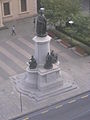
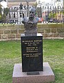
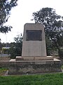 Monument on the corner of West Terrace (northern side)
 -
 Plaque on monument on the corner of West Terrace
 -

-
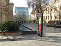
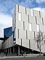 The Hawke Building, part of the UniSA, City West Campus
 -
 The Yungondi Building, part of the UniSA, City West Campus
 -
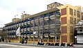
 The City West tram stop - left-to-right: InterContinental Hotel, Riverside Building, Morphett Street bridge, multi-storey accommodation, the old Lion Flour factory
 -

-
 Part of the Adelaide railway station building - main entrance
 -
 Parliament House with InterContinental Hotel
 -
 Opening of Parliament House, Adelaide, by the Governor-General, 5 June 1939.
 -
 View of the South African War Memorial, looking West along North Terrace, circa 1925
 -
 View of the South African War Memorial, looking West along North Terrace, circa 2008
 -
 View to south along King William Road towards intersection with North Terrace
 -
 Government House, Adelaide in the 1930s
 -

-
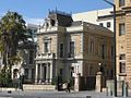
 The Adelaide Club, 165 North Terrace
 -
 The Queen Adelaide Club, cnr North Terrace and Stephens Place
 -

-
 View of North Terrace, looking east from near King William Street, circa 1940
 -
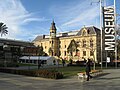
 Institute Building (1859), now part of the State Library, housing the Sir Donald Bradman collection
 -
 Statue of Edward VII in front of the Institute Building
 -
 State Library entrance to Spence Wing
 -
 Mortlock Wing of the State Library
 -
 South Australian Museum Complex
 -
 Art Gallery of South Australia and part of the South Australian Museum
 -
 Mitchell Building, University of Adelaide
 -
 Eastern side of Mitchell Building, University of Adelaide
 -
-

-

-
 Bonython Hall, University of Adelaide (looking west)
 -
 Freemasons' Hall
 -
 Waterhouse House
 -
 Waterhouse House history
 -
 Old School of Mines building c.2010 - after renovation
 -
 Looking south-west from Frome Road
 -
-
 Terrace Houses, East End
 -
 Botanic Hotel, cnr East and North Terraces
 -
 The old Royal Adelaide Hospital
 -
 Buildings on North Terrace
 -
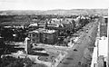
 North Terrace in 1930
 -
 North Terrace in 1935
 -
 Outside Parliament House, looking at North terrace (1940)


See also edit
![]() South Australia portal
South Australia portal
![]() Australian Roads portal
Australian Roads portal
References edit
- ^ Google (30 May 2022). "North Terrace" (Map). Google Maps. Google. Retrieved 30 May 2022.
- ^ 2003 Adelaide Street Directory, 41st Edition. UBD. 2003. ISBN 0-7319-1441-4.
- ^ Map of the Adelaide city centre, North Adelaide and the Adelaide Park Lands.
- ^ "InterContinental To Replace Hyatt In Adelaide". Spice News. 15 September 2009. Retrieved 21 November 2020.
- ^ "Yerrakartarta Mural, Adelaide". NixPixMix. 23 July 2012. Retrieved 21 November 2020.
- ^ "Art Gallery". Darryl Pfitzner Milika Home Page. 8 January 2015. Retrieved 21 November 2020.
- ^ "Yerrakartarta". The Rambling Wombat. 4 October 2017. Retrieved 21 November 2020.
- ^ Elton, Jude (7 January 2014). "14 Pieces". Adelaidia. Retrieved 9 February 2022.
- ^ a b Bonython Hall is opposite Pulteney Street, and was built in 1936 as a result of a donation of over £50,000 from Sir John Langdon Bonython. Pulteney Street is the only one of the city's north-south thoroughfares which does not continue north through the parklands. Folklore has it that the Bonython donation was made on the condition that a hall be built opposite Pulteney Street, thus blocking any future path through the parklands and preventing the division of the campus by a major thoroughfare.
- ^ "Stamford Plaza Adelaide · 150 North Terrace, Adelaide SA 5000, Australia". Google Maps. Retrieved 22 April 2023.
- ^ "Myer Centre (former Goldsbrough House)". Experience Adelaide. 16 September 2019. Retrieved 22 April 2024.
- ^ "Goldsbrough House: 172-174 North Terrace" (PDF). City of Adelaide. 1996.
The internal lift lobbies and stairwell are of particular note and have survived a major refurbishment to link the Myers department store through to North Terrace. The projected redevelopment of Myers will retain little more than the North Terrace facade.... The text in this Information Sheet was copied from the Heritage of the City of Adelaide: An Illustrated Guide (1996).
- ^ Queen Adelaide Club > Club history Archived 8 February 2015 at the Wayback Machine Accessed 15 January 2013.
- ^ "Lister House on North Terrace" (photo + text). State Library of South Australia. 16 February 1930. Retrieved 22 April 2024.
Lister House, erected on a vacant site in 1928-9, North Terrace east, 16 February 1930.
- ^ "Adelaide Lister House". Flickr. Retrieved 22 April 2024.
- ^ "Our History". Scots Church. Retrieved 8 December 2014.
- ^ "Electra House". Adelaide Explorer. Retrieved 13 August 2019.
- ^ "Freemasons Hall". Adelaide Explorer. Retrieved 13 August 2019.
- ^ "John Quinton Bruce". Architects [of South Australia] database. Retrieved 13 August 2019.
- ^ Official opening for tram extension ABC News 14 October 2007
- ^ Adelaide Entertainment Centre Tram Line Opens Trolley Wire issue 321 May 2010 pages 21-23
- ^ Boisvert, Eugene (13 October 2018). "Trams start running on Adelaide's North Terrace extension seven months late". ABC News. Australian Broadcasting Corporation. Retrieved 14 October 2018.