


Summary
Pataudi State was a small princely state in India, established in 1804 during the East India Company rule in India.
| Pataudi State | |||||||||
|---|---|---|---|---|---|---|---|---|---|
| Princely State | |||||||||
| 1804–1948 | |||||||||
 Flag | |||||||||
 Pataudi shown in Delhi Territory, south of Gurgaon, Imperial Gazetteer of India, 1908 | |||||||||
| Area | |||||||||
• 1901 | 135 km2 (52 sq mi) | ||||||||
| Population | |||||||||
• 1901 | 21,933 | ||||||||
| History | |||||||||
• Established | 1804 | ||||||||
| 1948 | |||||||||
| |||||||||

The state formed a part of the Delhi Territory in the Ceded and Conquered Provinces. It was under the suzerainty of the Commissioner of Delhi. It had an area of 52 square miles and included one town, Pataudi, and 40 villages, ruled by the Pataudi family.
History edit
The state of Pataudi was established in 1804 by the British East India Company, when Faiz Talab Khan, an Afghan Muslim Pashtun of the Barech tribe, who was made the first Nawab, aided them in their battle against the Maratha Empire, during the Second Anglo-Maratha War.[1] The family traces their origin to 16th century India, when their ancestors immigrated from present day Afghanistan to India during the period of the Lodi dynasty.[1] The 8th Nawab, Iftikhar Ali Khan Pataudi, played cricket for both England and India and captained the latter. His son the last Nawab also captained the Indian cricket team.
At the end of the British Raj and with the political integration of India in 1948, the princely state of Pataudi was absorbed into the new Dominion of India (later Republic of India). In 1971, by virtue of the 26th amendment to the Constitution of India, the Government of India abolished all official symbols of princely India, including titles, privileges, and remuneration (privy purses).[2][3]
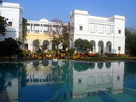
The former Pataudi Palace was a hotel for some time, but is now owned privately by Saif Ali Khan, the current patriarch of the family.
Rulers edit
Rulers bore the title of the Nawab.[4][5]
- Faiz Talab Khan (1804–1829)
- Akbar Ali Khan (1829–1862)
- Mohammad Ali Taqi Khan (1862–1867)
- Mohammad Mukhtar Husain Khan (1867–1878)
- Mohammad Mumtaz Husain Ali Khan (1878–1898)
- Mohammad Muzaffar Ali Khan (1898–1913)
- Mohammad Ibrahim Ali Khan (1913–1917)
- Mohammad Iftikhar Ali Khan (1917–1948)(1948-1952) (just as titular nawab after merging with India)
- Mansoor Ali Khan Pataudi (1952–1971) (Title abolished in 1971).
Demographics edit
| Religious group |
1901[6] | 1911[7][8] | 1921[9] | 1931[10] | 1941[11] | |||||
|---|---|---|---|---|---|---|---|---|---|---|
| Pop. | % | Pop. | % | Pop. | % | Pop. | % | Pop. | % | |
| Hinduism |
18,281 | 83.35% | 16,114 | 82.45% | 15,090 | 83.38% | 15,596 | 82.64% | 17,728 | 82.38% |
| Islam |
3,549 | 16.18% | 3,338 | 17.08% | 2,898 | 16.01% | 3,168 | 16.79% | 3,655 | 16.98% |
| Jainism |
103 | 0.47% | 82 | 0.42% | 109 | 0.6% | 105 | 0.56% | 128 | 0.59% |
| Christianity |
0 | 0% | 9 | 0.05% | 0 | 0% | 3 | 0.02% | 9 | 0.04% |
| Sikhism |
0 | 0% | 0 | 0% | 0 | 0% | 1 | 0.01% | 0 | 0% |
| Zoroastrianism |
0 | 0% | 0 | 0% | 0 | 0% | 0 | 0% | 0 | 0% |
| Buddhism |
0 | 0% | 0 | 0% | 0 | 0% | 0 | 0% | 0 | 0% |
| Judaism |
0 | 0% | 0 | 0% | 0 | 0% | 0 | 0% | 0 | 0% |
| Others | 0 | 0% | 0 | 0% | 0 | 0% | 0 | 0% | 0 | 0% |
| Total population | 21,933 | 100% | 19,543 | 100% | 18,097 | 100% | 18,873 | 100% | 21,520 | 100% |
| Note: British Punjab province era district borders are not an exact match in the present-day due to various bifurcations to district borders — which since created new districts — throughout the historic Punjab Province region during the post-independence era that have taken into account population increases. | ||||||||||
See also edit
Notes edit
- ^ 1931-1941: Including Ad-Dharmis
References edit
- ^ a b The Hindu, Sunday, 3 Aug 2003 - Royal vignettes: Pataudi: The Afghan connection
- ^ 1. Ramusack, Barbara N. (2004). The Indian princes and their states. Cambridge University Press. p. 278. ISBN 978-0-521-26727-4., "Through a constitutional amendment passed in 1971, Indira Gandhi stripped the princes of the titles, privy purses and regal privileges which her father's government had granted." (p 278). 2. Naipaul, V. S. (8 April 2003), India: A Wounded Civilization, Random House Digital, Inc., pp. 37–, ISBN 978-1-4000-3075-0, retrieved 6 November 2011 Quote: "The princes of India – their number and variety reflecting to a large extent the chaos that had come to the country with the breakup of the Mughal empire – had lost real power in the British time. Through generations of idle servitude they had grown to specialize only in style. A bogus, extinguishable glamour: in 1947, with Independence, they had lost their state, and Mrs. Gandhi in 1971 had, without much public outcry, abolished their privy purses and titles." (pp 37–38). 3. Schmidt, Karl J. (1995), An atlas and survey of South Asian history, M.E. Sharpe, p. 78, ISBN 978-1-56324-334-9, retrieved 6 November 2011 Quote: "Although the Indian states were alternately requested or forced into union with either India or Pakistan, the real death of princely India came when the Twenty-sixth Amendment Act (1971) abolished the princes' titles, privileges, and privy purses." (page 78). 4. Breckenridge, Carol Appadurai (1995), Consuming modernity: public culture in a South Asian world, U of Minnesota Press, pp. 84–, ISBN 978-0-8166-2306-8, retrieved 6 November 2011 Quote: "The third stage in the political evolution of the princes from rulers to citizens occurred in 1971, when the constitution ceased to recognize them as princes and their privy purses, titles, and special privileges were abolished." (page 84). 5. Guha, Ramachandra (5 August 2008), India After Gandhi: The History of the World's Largest Democracy, HarperCollins, pp. 441–, ISBN 978-0-06-095858-9, retrieved 6 November 2011 Quote: "Her success at the polls emboldened Mrs. Gandhi to act decisively against the princes. Through 1971, the two sides tried and failed to find a settlement. The princes were willing to forgo their privy purses, but hoped at least to save their titles. But with her overwhelming majority in Parliament, the prime minister had no need to compromise. On 2 December she introduced a bill to amend the constitution and abolish all princely privileges. It was passed in the Lok Sabha by 381 votes to six, and in the Rajya Sabha by 167 votes to seven. In her own speech, the prime minister invited 'the princes to join the elite of the modern age, the elite which earns respect by its talent, energy and contribution to human progress, all of which can only be done when we work together as equals without regarding anybody as of special status.' " (page 441). 6. Cheesman, David (1997). Landlord power and rural indebtedness in colonial Sind, 1865–1901. London: Routledge. pp. 10–. ISBN 978-0-7007-0470-5. Quote: "The Indian princes survived the British Raj by only a few years. The Indian republic stripped them of their powers and then their titles." (page 10). 7. Merriam-Webster, Inc (1997), Merriam-Webster's geographical dictionary, Merriam-Webster, pp. 520–, ISBN 978-0-87779-546-9, retrieved 6 November 2011 Quote: "Indian States: "Various (formerly) semi-independent areas in India ruled by native princes .... Under British rule ... administered by residents assisted by political agents. Titles and remaining privileges of princes abolished by Indian government 1971." (page 520). 8. Ward, Philip (September 1989), Northern India, Rajasthan, Agra, Delhi: a travel guide, Pelican Publishing, pp. 91–, ISBN 978-0-88289-753-0, retrieved 6 November 2011 Quote: "A monarchy is only as good as the reigning monarch: thus it is with the princely states. Once they seemed immutable, invincible. In 1971 they were "derecognized," their privileges, privy purses and titles all abolished at a stroke" (page 91)
- ^ "The Constitution (26 Amendment) Act, 1971", indiacode.nic.in, Government of India, 1971, retrieved 9 November 2011
- ^ "Indian states before 1947 K-W". www.rulers.org. Retrieved 31 August 2019.
- ^ "Indian Princely States K-Z". www.worldstatesmen.org. Retrieved 31 August 2019.
- ^ "Census of India 1901. [Vol. 17A]. Imperial tables, I-VIII, X-XV, XVII and XVIII for the Punjab, with the native states under the political control of the Punjab Government, and for the North-west Frontier Province". 1901. p. 34. JSTOR saoa.crl.25363739. Retrieved 30 March 2024.
- ^ "Census of India 1911. Vol. 14, Punjab. Pt. 2, Tables". 1911. p. 27. JSTOR saoa.crl.25393788. Retrieved 30 March 2024.
- ^ Kaul, Harikishan (1911). "Census Of India 1911 Punjab Vol XIV Part II". p. 27. Retrieved 30 March 2024.
- ^ "Census of India 1921. Vol. 15, Punjab and Delhi. Pt. 2, Tables". 1921. p. 29. JSTOR saoa.crl.25430165. Retrieved 30 March 2024.
- ^ "Census of India 1931. Vol. 17, Punjab. Pt. 2, Tables". 1931. p. 277. JSTOR saoa.crl.25793242. Retrieved 30 March 2024.
- ^ "Census of India, 1941. Vol. 6, Punjab". 1941. p. 42. JSTOR saoa.crl.28215541. Retrieved 30 March 2024.
External links edit
 Media related to Pataudi State at Wikimedia Commons
28°19′N 76°47′E / 28.32°N 76.78°E