


Summary
The River Bain is a river in Lincolnshire, England, and a tributary of the River Witham.[1][2]
| River Bain The Bain | |
|---|---|
 Tilting Gate Weir near Thornton | |
| Location | |
| Country | England |
| Region | Lincolnshire |
| Physical characteristics | |
| Source | |
| • location | Ludford, Lincolnshire Wolds, England |
| • elevation | 130 m (430 ft) |
| Mouth | River Witham |
• location | Dogdyke, Tattershall |
• coordinates | 53°5′0.1″N 0°11′45.8″W / 53.083361°N 0.196056°W |
| Basin features | |
| Tributaries | |
| • left | Out Gowt, River Waring, Haltham Beck |

The Bain rises in the Lincolnshire Wolds at Ludford,[3] a village on The Viking Way long-distance footpath, and flows through or past the villages of Burgh on Bain, Biscathorpe, Donington on Bain, Goulceby, Asterby and Hemingby before reaching the town of Horncastle where it is joined by the River Waring, which rises at Belchford, 5 miles (8.0 km) to the north east of Horncastle.[3][1]
After leaving Horncastle, the Bain flows through the villages of Kirkby on Bain, Coningsby and Tattershall, and joins the Witham at Dogdyke.[1] In the late eighteenth and early nineteenth centuries, and after protracted negotiation, a group of venture capitalists led by Sir Joseph Banks[3] canalized the Bain between Horncastle and the Witham. The Horncastle Canal opened in 1802[3] and was an important goods route before the coming of the railway. It is no longer navigable, but is used extensively by anglers, canoeists, and naturalists.
The river contains significant populations of chub (Leuciscus cephalus), bream,[4] roach and rudd, as well as brown trout, pike, eel, and smaller species such as miller's thumb (Cottus gobio), gudgeon and stone loach (Nœmacheilus barbatus). It is also home to the threatened species of crayfish Austropotamobius pallipes, though there are also populations of the introduced American signal crayfish (Pasifastacus leniusculus), which competes with the native species for food.[5][6][7]
The Bain valley was formed by a glacier in the most recent ice-age and, although small, is very obvious.[7] The River Bain is very susceptible to flooding and many floods have occurred during its history, about once every 30–50 years, the most recent being the 2007 United Kingdom floods, when the river overtopped its banks all along its course. Horncastle was particularly badly hit.[8]
Settlements in the valley include Tattershall, Coningsby, Kirkby on Bain, Haltham, Roughton, Horncastle, Hemingby, Goulceby with Asterby, Donington on Bain, Burgh on Bain and Ludford.[1]

Crossings of the River Bain/Horncastle Canal edit
This list is incomplete.
| Number | Name | Locality | Date | Type | Notes | Image |
|---|---|---|---|---|---|---|
| 1 | Footbridge by at mouth by the River Witham | Dogdyke | On location of the Lincolnshire Loop Line railway bridge. | |||
| 2 | Footbridge at Tattershall Lakes Country Park | Dogdyke | Public Footpath | |||
| 3 | Bridge at Coningsby Ings Pumping Station | Coningsby Ings near Tattershall Castle | Private access | |||
| 4 | Tattershall Sluice | Tattershall Castle | Steel Truss | Public Footpath | 
| |
| 5 | A153 Road Bridge | Coningsby/Tattershall | Concrete Beam | 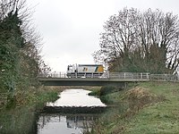
| ||
| 6 | Mason's Bridge | Coningsby/Tattershall | Steel Beam | Public Footpath |
 | |
| 7 | Old Railway Bridge | Coningsby/Tattershall | Brick Arch | Disused. Formerly carried the Kirkstead and Little Steeping Railway. | 
| |
| 8 | Coningsby Lock Bridge | Coningsby/Tattershall | Concrete Beam | Carries Wharf Lane | ||
| 9 | Farm Track Bridge | Tumby | Private access | |||
| 10 | Farm Track Bridge | Tumby | Private access | |||
| 11 | Bridge at Fulsby Lock | Fulsby | Public Bridleway | |||
| 12 | Footbridge at St Mary's Church | Kirkby on Bain | Concrete Beam | Public Footpath | 
| |
| 13 | Footbridge in Kirkby on Bain | Kirkby on Bain | Private access | |||
| 14 | Bridge at Kirkby Water Mill | Kirkby on Bain | Public Footpath. Rebuilt after 2007 floods. | |||
| 15 | Red Mill Bridge | Kirkby on Bain/Haltham | Brick Arch | Carries Rime's Lane. | ||
| 16 | Footbridge at Haltham Lock | Haltham | Concrete Beam | Public Footpath | 
| |
| 17 | Footbridge at Roughton | Roughton | Public Footpath | |||
| 18 | Bridge at Roughton Lock | Roughton | Private access | |||
| 19 | Bridge at Dalderby Lock | Dalderby | Concrete Beam | Public Bridleway | ||
| 20 | Fifty Acre Bridge | Thornton/Horncastle | Carries the Fifty Acre Road. Rebuilt December 2015. | |||
| 21 | Footbridge at Horncastle Swimming Pool | Horncastle | Concrete Beam | Public Footpath | ||
| 22 | A158/Jubilee Way Road Bridge | Horncastle | ||||
| 23 | Bridge Street | Horncastle | 
| |||
| 24 | Bridge at Tesco | Horncastle | Concrete Beam | Public access. | 
| |
| 25 | Thimbleby Mill Bridge | Horncastle | Public Footpath. Part of Thimbleby Mill infrastructure | |||
| 26 | Thimbleby Mill Footbridge | Horncastle | Public Footpath | |||
| 27 | Sherman's Wath Bridge | West Ashby | Carries Sherman's Wath (Road) | |||
| 28 | Bridge at Ashby Park | West Ashby | Private access | |||
| 29 | Bridge at Horncastle Golf and Country Club | West Ashby | Private access | |||
| 30 | Bridge at Horncastle Golf and Country Club | Hemingby | Private access | |||
| 31 | Hemingby Bridge at Upper Bain Weir | Hemingby | Concrete Beam | Carries public highway | ||
| 32 | Bridge at Watermill Farm | Baumber | Private access | |||
| 33 | Market Bridge | Great Sturton | Concrete Beam | Restricted Byway. Crossing of the Bain by the Lincoln to Skegness Roman Road at this location. | 
| |
| 34 | Bridge at Square Plantation | Ranby | Private access | |||
| 35 | Bridge at Ranby | Ranby | Private access | |||
| 36 | Bridge at Willow Holt | Goulceby | Private access | |||
| 37 | Top Lane Bridge | Goulceby | Public highway | |||
| INCOMPLETE |
This list is incomplete.
References edit
- ^ a b c d Lincolnshire Wolds South:Horncastle & Woodhall Spa (Map) (A1 ed.). 1:25000. Explorer. Ordnance Survey. p. 273. ISBN 9780319238219.
Boston:Tattershall, Billinghay & Heckington (Map) (A1 ed.). 1:25000. Explorer. Ordnance Survey. p. 261. ISBN 9780319238172. - ^ "Mapping the River Bain". River Bain Projects. Salmon & Trout Association (Lincolnshire branch). Retrieved 26 October 2013.
- ^ a b c d J. N. Clarke, (1990), The Horncastle and Tattershall Canal, Oakwood Press, ISBN 0-85361-398-2
- ^ Martin James, (2001), A Big Bream from a Little River, retrieved 22 November 2008
- ^ "Signal crayfish". River Bain Projects. Salmon & Trout Association (Lincolnshire branch). Retrieved 26 October 2013.
- ^ "Witham Catchment" (PDF). Environment agency. Retrieved 26 October 2013.
signal crayfish are present in the River Bain , increasing the amount of fine sediment in rivers
- ^ a b Windrum, Andrew. "Lincolnshire Wolds" (PDF). Natural area concept Profiles. Natural England. Retrieved 26 October 2013.
- ^ Horncastle News, (23 July 2007), Floods return to Horncastle