


Summary
The River Washburn is a river in Yorkshire, England. It originates high in the Yorkshire Dales and ends where it meets the River Wharfe. It lies within the Nidderdale Area of Outstanding Natural Beauty.[2]
| River Washburn | |
|---|---|
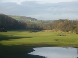 The River Washburn approaching Lindley Wood Reservoir | |
| Location | |
| Country | England |
| Physical characteristics | |
| Source | |
| • location | Washburn Head |
| • coordinates | 54°3′46″N 1°50′50″W / 54.06278°N 1.84722°W |
| • elevation | 391 m (1,283 ft) |
| Mouth | |
• location | River Wharfe near Pool |
• coordinates | 53°54′39″N 1°39′6″W / 53.91083°N 1.65167°W |
• elevation | 49 m (161 ft) |
| Length | 26 km (16 mi) |
| Basin size | 87.3 km2 (33.7 sq mi)[1] |
Name edit
The earliest recorded form of the river's name was Walkesburn, from the early 12th century. The name is thought to come from an Old English personal name Walc, not otherwise recorded, so means "stream of a man named Walc".[3]
Course edit
The river's source is at Washburn Head, just south of Stump Cross Caverns. From there it flows southwards via Thruscross Reservoir, Blubberhouses, Fewston Reservoir, Swinsty Reservoir and Lindley Wood Reservoir, before joining the River Wharfe just north-west of Pool-in-Wharfedale near Leathley.[4]
Reservoirs edit
The Washburn has been dammed to a series of four reservoirs, all built to supply water to the city of Leeds. The lower three (Lindley Wood, Swinsty and Fewston) were built at the end of the 19th century, while the fourth, Thruscross, was delayed until the 1960s.[5] Fewston and Swinsty reservoirs have a surface area of around 1.6 square kilometres (0.62 sq mi) and a combined length of 4.1 kilometres (2.5 mi); Thackray Beck and Spinksburn Beck are major tributaries flowing into these reservoirs.[6] Capelshaw Beck is the main tributary flowing into Thruscross reservoir.[2]
Geology edit
Where the valley has not been flooded to make reservoirs, the sides are V-shaped. The valley floor consists of solid Millstone Grit overlain with till drift. The drainage can be described as slowly permeable and seasonally waterlogged. The bedrock is covered with fine loam over clay soils and some peat soils at higher elevations on the fringe of the moorland.[2][6][7]
Geography edit
The river valley has grassland that is intensively managed for livestock. There are also a range of field sizes, bounded by stonewalls that are often reinforced with post and wire fencing, plus some post and rail fencing. There are very large conifer forestry plantations around the reservoirs as well as at Beecroft Moor Plantation, with conifer shelterbelts at Carlhow Ridge Plantation. Deciduous tree clumps can be found around settlements. Ancient semi-natural woodland can still be seen at Blubberhouses, Folly Hall Wood, Hanging Wood and Ellers Wood. There is evidence of past quarrying of local stone for buildings and walls. The river valley is crossed by the Harrogate Dales Way Link.[2][6]
Kayaking edit
The section of the river between Thruscross Reservoir and Fewston Reservoir is used for whitewater kayaking when water is released by Yorkshire Water.[8]
Heritage Centre edit
The Washburn Heritage Centre, adjacent to Fewston Church, opened in February 2011.[9]
Further reading edit

- The Washburn by Tom Bradley (published 1895, reprinted 1988)
- Washburn Valley Yesterday Vol II by David Alred. ISBN 1-85825-160-5
See also edit
References edit
- ^ "Washburn Statistics". National River Flow Archives. Centre for Ecology & Hydrology. Retrieved 18 February 2011.
- ^ a b c d "Upper Washburn Valley Landscape Character Assessment" (PDF). Retrieved 27 August 2017.
- ^ Watts, Victor, ed. (2010), "Washburn", The Cambridge Dictionary of English Place-Names, Cambridge University Press, ISBN 9780521168557
- ^ "Memories of winters past from Washburn Heritage Centre". Wharfedale Observer. 3 December 2021. Retrieved 16 May 2023.
- ^ Bowtell, Harold D. (1991). Lesser Railways of the Yorkshire Dales and the Dam Builders in the Age of Steam. Plateway Press. ISBN 1-871980-09-7.
- ^ a b c "Middle Washburn Valley Landscape Character Assessment". Retrieved 27 August 2017.
- ^ "Y.G.S.Extract". Retrieved 1 May 2011.
- ^ "Washburn Calendar". British Canoeing. Retrieved 8 February 2020.
- ^ "About Us". Washburn Heritage Centre. Retrieved 11 August 2018.