


Summary
The Sea Cut (Scalby Beck)[note 3][3] is a small river that enters the North Sea at Scalby Mills, Scarborough, North Yorkshire, England. The beck is fed from local streams in Scalby, Newby and Burniston and other watercourses draining off the nearby hills. It is also a bypass channel for the upper reaches of the River Derwent when it is under flood conditions.
| Sea Cut (Scalby Beck) | |
|---|---|
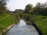
 Scalby Beck (Sea Cut) meandering to its mouth at Scalby Mills | |
| Location | |
| Country | England |
| County | North Yorkshire |
| District | Scarborough |
| Physical characteristics | |
| Source | |
| • location | Suffield-cum-Everley |
| • elevation | 41 m (135 ft) |
| Mouth | Scalby Ness |
• location | Scalby Mills |
• elevation | 0 m (0 ft) |
| Length | 8 km (5.0 mi) |
| Basin size | 32.126 km2 (12.404 sq mi)[note 1][1] |
| Basin features | |
| Tributaries | |
| • left | North Back Drain, Church Beck, Cow Wath Beck[note 2][2] |
| • right | Throxenby Beck, Newby Beck |
Sea Cut (Scalby Beck) | |||||||||||||||||||||||||||||||||||||||||||||||||||||||||||||||||||||||||||||||||||||||||||||||||||||||||||||||||||||||||||||||||||||||||||||||||||||||||||||||||||||||||||||||||||||||||||||||||||||||||||||||||||||||||||||||||
|---|---|---|---|---|---|---|---|---|---|---|---|---|---|---|---|---|---|---|---|---|---|---|---|---|---|---|---|---|---|---|---|---|---|---|---|---|---|---|---|---|---|---|---|---|---|---|---|---|---|---|---|---|---|---|---|---|---|---|---|---|---|---|---|---|---|---|---|---|---|---|---|---|---|---|---|---|---|---|---|---|---|---|---|---|---|---|---|---|---|---|---|---|---|---|---|---|---|---|---|---|---|---|---|---|---|---|---|---|---|---|---|---|---|---|---|---|---|---|---|---|---|---|---|---|---|---|---|---|---|---|---|---|---|---|---|---|---|---|---|---|---|---|---|---|---|---|---|---|---|---|---|---|---|---|---|---|---|---|---|---|---|---|---|---|---|---|---|---|---|---|---|---|---|---|---|---|---|---|---|---|---|---|---|---|---|---|---|---|---|---|---|---|---|---|---|---|---|---|---|---|---|---|---|---|---|---|---|---|---|---|---|---|---|---|---|---|---|---|---|---|---|---|---|---|---|
| |||||||||||||||||||||||||||||||||||||||||||||||||||||||||||||||||||||||||||||||||||||||||||||||||||||||||||||||||||||||||||||||||||||||||||||||||||||||||||||||||||||||||||||||||||||||||||||||||||||||||||||||||||||||||||||||||
History edit
The Sea Cut is fed by small streams and becks mainly draining water away from the hills on the western side of Scalby and Newby. In response to major flooding on the River Derwent in 1799, a canalised beck was cut between Everley and Newby Bridge (the present day A171 road bridge that spans the beck between Newby and Scalby).[4] The Sea Cut was primarily to stop flooding in West and East Ayton further downstream.[2] This means that water flowing in the River Derwent takes 150 miles (240 km) before reaching the sea via the Humber Estuary as opposed to the relatively short distance via the Sea Cut.[5] This scheme, along with others in the area (straightening of the Derwent and Hertford rivers and land drainage) was promoted by Sir George Cayley and William Chapman with Robert Wilson employed as engineer for the Sea Cut navigation.[6]
During the Ice Age, the water flowed to the sea along the course of the Sea Cut before glacial mud build up caused what is now the Derwent river to change course and lead to it flowing westwards away from the North Sea.[7]
The Sea Cut (or New Cut) was opened on 3 September 1804 and extended to 3 miles (4.8 km)[8] with a width of 9.1 metres (30 ft) and a drop of 41 metres (135 ft).[6] Ten weirs were built along its length to control the energy of the floodwaters[9] with the weir head at Everley controlling the flow of the Sea Cut by use of a sluice gate allowing floodwater over the weir when the Derwent is in spate, but maintaining the flow of water in the Derwent when dryer conditions prevail.[10] The sluice gate at Everely is designed specifically to not allow floodwater to enter the Derwent. Instead the majority of the floodwater is diverted down the Sea Cut.[11]
Local businessmen, entrepreneurs and farmers all gathered together to make the scheme viable as it would also provide additional land for agriculture.[12] A new bridge was built for Mowthorp Road as part of the scheme (which is now Grade II listed)[13] with the other crossing points in Scalby having had many bridges throughout human history, although they were all replaced in the latter part of the 19th or the early part of the 20th century (Newby Bridge was washed away in a flood in August 1890.[14] Whitby Road Bridge (the A165 road) was rebuilt in 1906).[15]
The beck's outfall into the North Sea was further south than where it is now. Adjacent to the Sea Life Centre at Scarborough was a coastal island known as Monkey Island. This was large enough to play cricket and football on top of it[16] and the Sea Cut used to run between the coast and Monkey Island and enter the sea further south on the coast towards Peasholm.[17] Monkey Island was lost to coastal erosion[18] and the remains were finally removed in 1961 after its location became part of what is now the Scarborough Sea Life Centre.[19]
Route edit

The watercourse starts in the parish of Suffield-cum-Everley near to Mowthorpe Farm. This is where the River Derwent turns south away from the coast. The Sea Cut runs for 3.1 miles (5 km)[20] due eastwards flowing over three weirs on the way in a fairly straight sided channel as this is the cut section. It flows under Mowthorp Road (C71) and then flows north eastwards before reaching the Hackness Road (C251).[21] This is where the canalised section ends and the last 1.9 miles (3 km) is known as Scalby Beck. Traditionally, where Church Beck joins the main watercourse, it was known as Scalby Beck.[22]
The beck flows on underneath the A171 road at Newby Bridge; hereafter it is more of a meander as this is the natural course of water before the new cut further upstream was added. The beck then flows under the viaduct of the former Scarborough to Whitby Railway and the A165 road before flowing through a deep channel in heathland at Scalby Ness[23] then flowing out into the North Sea by Scalby Mills and Scarborough Sea Life Centre.[24] The last section had the watermills and still has the seven out of ten on the entire watercourse.[25]
Control of floodwaters and flood prevention is the responsibility of the Environment Agency as the Sea Cut is designated as a main river alongside the Derwent, the Hertford and the Esk rivers. The becks that flow into the Sea Cut and Scalby Beck are maintained by Scarborough Borough Council.[26]
Industrial history edit
The Sea Cut and its banks were used to support all manner of industries. Chief amongst these were the four mills that lined the beck, two of which are still extant; one, a former 17th century watermill, which is now a Youth Hostel on the A165 road[27] and the Low Mill at Scalby Mills which is a public house[28] having been converted from a mill by 1854.[29]
High Mill, and its associated buildings, still exist as High Mill Farm and are Grade II listed. The history of milling on this site goes back to 1609 (though the current building were built in the 1840s). High Mill made good use of the increased water flow on Scalby Beck by building a mill race to power its waterwheel. The mill race has since been filled in with earth.[30]
The corn mill that operated as Newby Bridge was opened in the mid 18th century and had closed by the 1950s.[31] It received its corn via the railway at Scalby railway station.[32] This mill was adjacent to the A165 bridge further downstream from Newby, but was known as Newby Bridge Mill.[33]
Coastal surveys have identified a Smallpox isolation hospital and a rifle range in the lower reaches of the beck.[34] The rifle range was used in the First and Second World Wars.[35]
Ecology edit
When the Sea Cut was drained for repairs in 2014, a colony of 100 Crayfish were removed for safety and then returned to the beck when the remediation works had taken place.[36]
Many obstacles prevent fish from migrating up the beck (notably the weirs) and steps have been taken to alleviate this problem. In autumn 2012, a special fish pass was installed on the weir adjacent to the Burniston Road Bridge (the A165). Scalby Beck Angling Club spent £9,000 on the wooden structure which is the same as another successful fish pass installed further up the beck.[37] Another barrier to fish migration is the weir at the mouth of the beck. There is a concrete pipe which was originally built to carry sewage and deposit it onto the beach further north. Apart from high tide, fish migration is very difficult here.[38]
Scalby Beck provides the only substantial sea trout and salmon spawning area between the River Esk at Whitby and the Humber Estuary.[39] Otters have been recorded on the beck, too.[40]
The lower reaches of the beck have been notified as a Site of Importance for Nature Conservation (SINC).[41]
Access edit
In the upper reaches of the Cut, when it makes its way across the flat terrain west of Scalby, the Cut can be accessed by paths and bridleways on both the northern and southern banks. The Tabular Hills Walk runs along the southern bank from the A171 Road bridge to Mowthorpe Farm on Mowthorp Road. The walk stretches for 48 miles (77 km) from Scalby Mills to Helmsley.[42]
The lower reaches of the Cut from the A171 Road to the mouth are steeper and access is controlled by Scalby Beck Angling Club.[43]
The mouth of the beck is accessible via a footbridge that carries the Cleveland Way. The mouth is also adjacent to Scalby Mills and Scarborough Sea Life Centre, so access is easy there too.[44]
Gallery edit
-
 Sea Cut Weir, Suffield cum Everley; the Derwent is out of shot on the left. This view is looking north west.
 -
 Sea Cut looking towards Scalby. The Tabular Hills Way is on the right.
 -
 Weir on Sea Cut from A171 bridge looking east.
 -
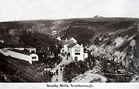 Scalby Mills, Scarborough North Yorkshire England 1901 - 1910 before the footbridge that carries the Cleveland Way was built.


Notes edit
References edit
- ^ "Burniston Beck/Sea Cut/Scalby Beck Catch to N Sea". Catchment Data Explorer. Environment Agency. Retrieved 26 October 2016.
- ^ a b Moore, Andrew; Hicks, Felicia (February 2010). "North East Yorkshire Strategic Flood Risk Assessment" (PDF). North York Moors.org. 11.1.1: Ryedale DC, Scarborough BC & North York Moors NPA. p. 89. Retrieved 26 October 2016.
{{cite web}}: CS1 maint: location (link) - ^ "Scalby, North Riding". Vision of Britain. Retrieved 31 October 2016.
- ^ Lidster 2013, p. 9.
- ^ Dillon, Paddy (2005). "Walk 1 West Ayton, Hackness and the Forge Valley". The North York Moors (3 ed.). Milnthorpe: Cicerone. p. 24. ISBN 9781852844486.
- ^ a b Rennison, Robert William; Barbey, M F (1996). "5. York & North Yorkshire". Civil engineering heritage: Northern England (2 ed.). London: Thomas Telford. pp. 144–145. ISBN 978-0-7277-2518-9.
- ^ Cowper Reed, F R (1900). The geological history of the rivers of East Yorkshire. London: Clay & Sons. pp. 89–91. OCLC 11368522.
- ^ Skempton, A W; Chrimes, M M; Cox, R C; Cross-Rudkin, P S M; Rennison, R W; Ruddock, E C, eds. (2002). "William Chapman MRIA". A biographical dictionary of civil engineers in Great Britain and Ireland, Volume 1: 1500–1830. London: Thomas telford. p. 126. ISBN 0-7277-2939-X.
- ^ "Scalby Beck Project" (PDF). East Yorkshire Chalk Rivers Trust. July 2012. Retrieved 31 October 2016.
- ^ "Derwent Consultation Report" (PDF). Environment Data. Environment Agency. February 1997. p. 88. Retrieved 27 October 2016.
- ^ "River Derwent Catchment Management Plan; Consultation Report" (PDF). Environment Data. National Rivers Authority. p. 61. Retrieved 30 October 2016.
- ^ Hurley, Mike (26 November 2015). "History of the Sea Cut". The Scarborough News. p. 55. ISSN 2050-5159.
- ^ Historic England. "Mowthorp Bridge (1296523)". National Heritage List for England. Retrieved 27 October 2016.
- ^ "SCALBY: Geographical and Historical information from the year 1890". Genuki. Retrieved 29 October 2016.
- ^ "Land East of Scalby Road Scalby North Yorkshire Archaeological Desk Based Assessment Proposed New Rugby Club TA 0145 9146" (PDF). Archaeology Data Service. 5 September 2006. p. 13. Retrieved 27 October 2016.
- ^ "B.Coastal Locations outside the harbour, within the bounds of Scarborough". Scarborough Maritime Heritage Centre. Retrieved 27 October 2016.
- ^ "Landslip is monkey business". The Scarborough News. 28 April 2008. Retrieved 26 October 2016.
- ^ Yeomans, Fay (13 November 2014). "Right on track!". BBC York & North Yorkshire. BBC. Retrieved 27 October 2016.
- ^ "After Monkey Island: the Scalby Mills site". Stories from Scarborough. Retrieved 27 October 2016.
- ^ "101" (Map). Scarborough & Bridlington (D2 ed.). 1:50,000. Landranger. Ordnance Survey. 2006. ISBN 9780319229057.
- ^ "Footpaths 1 Newby & Scalby and 204 Suffield cum Everley Sea Cut south Temporary Closure Order 2016" (PDF). North York Moors. 2 September 2016. Retrieved 29 October 2016.
- ^ "Scalby Conservation Area" (PDF). North York Moors.org. Scarborough Borough Council. 7 January 2008. p. 16. Retrieved 29 October 2016.
- ^ Pedley, Gareth (11 April 2014). "Advisory Visit to Scalby Beck, Nr Scarborough" (PDF). Wild Trout Trust. Wild Trout Trust. p. 1. Retrieved 27 October 2016.
- ^ "Route with a view". The Scarborough News. 15 November 2012. Retrieved 31 October 2016.
- ^ Rainsley, Mark (2003). "North York Moors". English White Water. Bangor: Pesda Press. p. 201. ISBN 0-9531956-7-8.
- ^ "Flooding (advice)". Scarborough.gov.uk. Retrieved 31 October 2016.
- ^ "YHA Scarborough". YHA Yorkshire. Retrieved 27 October 2016.
- ^ "Home". Old Scalby Mills. Retrieved 27 October 2016.
- ^ Brigham, T (September 2014). "Rapid Coastal Zone Assessment Survey Yorkshire and Lincolnshire: Phase 3" (PDF). English Heritage. North Yorkshire: Humber field archaeology. p. 186. Retrieved 27 October 2016.
- ^ Historic England. "Farmhouse and outbuildings, High Mill Farm (1393533)". National Heritage List for England. Retrieved 29 October 2016.
- ^ "Land East of Scalby Road Scalby North Yorkshire Archaeological Desk Based Assessment Proposed New Rugby Club TA 0145 9146" (PDF). Archaeology Data Service. 5 September 2006. p. 14. Retrieved 27 October 2016.
- ^ Lidster 2013, p. 39.
- ^ "Scalby; Scalby Beck". Mills database. Retrieved 31 October 2016.
- ^ Buglass, J; Brigham, T (June 2008). "Rapid Coastal Zone Assessment Survey, Yorkshire & Lincolnshire: Whitby to Reighton" (PDF). Historic England. Modern: Humber Archaeology. p. 57. Retrieved 26 October 2016.
- ^ Brigham, T (September 2014). "Rapid Coastal Zone Assessment Survey Yorkshire and Lincolnshire: Phase 3" (PDF). English Heritage. North Yorkshire: Humber field archaeology. pp. 133–134. Retrieved 27 October 2016.
- ^ "Scarborough Sea Cut crayfish moved for weir repairs". BBC News. 30 June 2014. Retrieved 26 October 2016.
- ^ "Boost for fish stocks in beck thanks to club's new 'pass'". The Scarborough News. 7 October 2012. Retrieved 26 October 2016.
- ^ Pedley, Gareth (11 April 2014). "Advisory Visit to Scalby Beck, Nr Scarborough" (PDF). Wild Trout Trust. Wild Trout Trust. pp. 3, 20. Retrieved 27 October 2016.
- ^ "Derwent Consultation Report" (PDF). Environment Data. Environment Agency. February 1997. p. 102. Retrieved 27 October 2016.
- ^ "FOIA3351 Response" (PDF). Scarborough.gov.uk. Wold Ecology. p. 15. Retrieved 30 October 2016.
- ^ Tempany, Andrew; Leach, Hannah (February 2013). "Scarborough Landscape Study: Volume 1 – Borough wide Landscape Character Assessment" (PDF). scarborough.gov.uk. Land Use Consultants. p. 78. Retrieved 8 April 2018.
- ^ "The Tabular Hills Walk". National Trails. Retrieved 26 October 2016.
- ^ Pedley, Gareth (11 April 2014). "Advisory Visit to Scalby Beck, Nr Scarborough" (PDF). Wild Trout Trust. Wild Trout Trust. pp. 1–2. Retrieved 27 October 2016.
- ^ "Scarborough – Scalby Mills to Cloughton Wyke round". Walking with the taxi driver. Retrieved 30 October 2016.
Bibliography edit
- Lidster, Robin (2013). Newby & Scalby through time. Amberley Publishing. ISBN 978-1-84868-670-0.
External links edit
54°17′44.9″N 0°26′53.6″W / 54.295806°N 0.448222°W
- Aerial shot of Sea Cut entering North Sea. Scalby Mills is centre right and Monkey Island is the small hill on the shoreline in the middle.
- 1947 mapping showing position of rifle range and smallpox hospital on lower reaches
- Map showing pre-glacial and post Glacial drainage of the Derwent