


Summary
The Serra de Monchique (Monchique Range) is a chain of mountains in the western part of the Algarve region of Portugal, about 20 km inshore. The chain's highest point is the peak of Fóia, at 902 m. 774 m high Picota is another notable peak.
| Monchique Range | |
|---|---|
| Serra de Monchique | |
 View of the Serra de Monchique | |
| Highest point | |
| Peak | Fóia |
| Elevation | 902 m (2,959 ft) |
| Coordinates | 37°19′N 8°36′W / 37.317°N 8.600°W |
| Dimensions | |
| Length | 32 km (20 mi) NE/SW |
| Width | 7 km (4.3 mi) NW/SE |
| Geography | |
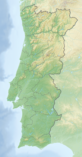 | |
| Country | Portugal |
| Region | Algarve |
| Range coordinates | 37°19′N 8°36′W / 37.317°N 8.600°W |
| Geology | |
| Orogeny | Alpine |
| Age of rock | Late Cretaceous |
| Type of rock | Syenite, slate |
Description edit
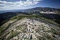
The Monchique Range is the southwesternmost mountain range of the Iberian Peninsula. It is covered in forest and parts of the range have been transformed into eucalyptus, pine and acacia plantations which are detrimental to the native forest cover.[1] The range is named after the town of Monchique, located in the area.[2] Caldas de Monchique is a well-known spa town with geothermal springs also located in this range.
Rivers Seixe, Aljezur and Odiáxere have their sources in this range.
Geology edit
The Monchique Range is part of the Late-Cretaceous Iberian Alkaline Igneous Province and is related to the Mount Ormonde seamount in the Gorringe Bank.[3] The inselberg is formed primarily of nepheline-syenites (foyaite, for which 'Foia' is the type locality). At c.63 km2 Monchique the fourth largest miaskitic nepheline-syenite intrusion so far discovered. It is assumed to be of 'laccolithic' form, from its regular contact altitude to the Breijera formation (country rock).[4] Pegmatites of similar foyaitic composition are seen within the mass at two locations and an associated dyke swarm of lamprophyres and picrites extends some 3 km from the mountain. the psammite/shale/marl country rocks of the Breijera formation are well exposed to the west of Serra de Monchique, forming jagged outcrops and dramatic gorges, which since the destructive introduction of eucalyptus farming in 1976,[5] now run dry most of the year round.
Ecology edit
Serra de Monchique is threatened by continued aggressive eucalyptus 'cash-crop' farming, recent publications have shown the water table to be lowering significantly and many endemic species to be on the brink of extinction, including the Bonellis Eagle,[6] the Iberian emerald lizard[7] and many more listed under European Union protection.
-
 View of Monchique
 -
 View of the rough Algarvian terrain and the Atlantic Ocean
 -
 Eucalyptus plantations
 -
 Stream at Barranco de Pisões


See also edit
References edit
- ^ Profiling Portugal - the Serra de Monchique
- ^ Monchique - Algarve - Portugal
- ^ Continental Lithospheric Contribution to Alkaline Magmatism: Isotopic (Nd, Sr, Pb) and Geochemical (REE) Evidence from Serra de Monchique and Mount Ormonde Complexes
- ^ Rock, N. M. S. (1982-04-15). "The Late Cretaceous Alkaline Igneous Province in the Iberian Peninsula, and its tectonic significance". Lithos. 15 (2): 111–131. doi:10.1016/0024-4937(82)90004-4.
- ^ "How the Eucalyptus Tree Empties Wells and Feeds Forest Fires in Portugal". Ecopoliticstoday's Blog. 2014-06-08. Retrieved 2016-06-22.
- ^ "Written question - Quarries in Natura 2000 area, Monchique, Portugal - E-004949/2011". www.europarl.europa.eu. Retrieved 2016-06-22.
- ^ Brito, José C.; Godinho, Raquel; Luı́s, Cristina; Paulo, Octávio S.; Crespo, Eduardo G. (1999-08-01). "Management strategies for conservation of the lizard Lacerta schreiberi in Portugal". Biological Conservation. 89 (3): 311–319. doi:10.1016/S0006-3207(99)00002-6.
External links edit
 Media related to Serra de Monchique at Wikimedia Commons
- Around Monchique and the mountains