


Summary
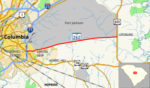
South Carolina Highway 262 (SC 262) is a 14.750-mile (23.738 km) primary state highway in the U.S. state of South Carolina. It serves primarily as the southern border of Fort Jackson.
South Carolina Highway 262 | ||||
|---|---|---|---|---|
| Leesburg Road | ||||
 | ||||
| Route information | ||||
| Maintained by SCDOT | ||||
| Length | 14.750 mi[1] (23.738 km) | |||
| Existed | 1940–present | |||
| Major junctions | ||||
| West end | ||||
| East end | ||||
| Location | ||||
| Country | United States | |||
| State | South Carolina | |||
| Counties | Richland | |||
| Highway system | ||||
| ||||

Route description edit

Starting from Garners Ferry Road, U.S. Route 76 (US 76) and US 378, it connects with Interstate 77 (I-77) before continuing as a 4 lane road until Fairmont Rd (S-88) then continues as a two lane road to US 601.[2]
History edit
Established in 1937 or 1938 as a new primary route going east, it started off as a seven miles (11 km) paved stub road, going east from US 76. In 1940, it was extended along a dirt road to US 601; which was later paved by 1942. In 1948, it was briefly decommissioned, but reinstated a year later. Since its inception, it has served as the southern boundary for Fort Jackson for its entire length.[3]
Junction list edit
The entire route is in Richland County.
| Location | mi[1] | km | Destinations | Notes | |
|---|---|---|---|---|---|
| Columbia | 0.000 | 0.000 | Western terminus | ||
| 0.120– 0.150 | 0.193– 0.241 | Access to I-77 southbound via US 76/US 378; I-77 exit 9B | |||
| Leesburg | 14.750 | 23.738 | Eastern terminus | ||
| 1.000 mi = 1.609 km; 1.000 km = 0.621 mi | |||||
See also edit
 U.S. roads portal
References edit
- ^ a b "Highway Logmile Report". South Carolina Department of Transportation. Retrieved November 24, 2020.
- ^ Google (November 23, 2012). "Overview map of SC 262" (Map). Google Maps. Google. Retrieved November 23, 2012.
- ^ "SC 262". Mapmikey's South Carolina Highways Page. Retrieved November 24, 2020.[unreliable source]
External links edit
 Media related to South Carolina Highway 262 at Wikimedia Commons