


Summary
Vavuniya (Tamil: வவுனியா, Romanized: Vavuniya, Sinhala: වවුනියාව, Romanized: Vavuniyāva) is a city of Vavuniya District in the Northern Province of Sri Lanka. The municipality is administered by an Municipal Council. The town has been known since ancient times, but being a heavily forested area, less than 100,000 people lived in the entire district before the Sri Lankan Civil War. The city is situated as a border town that divides the Tamil and Sinhalese population. To the south of the city are the Sinhala cities and to the north are the Tamil cities. The city has a large population of Tamils, Muslims and a significant number of Sinhalese. In the early days, Vavuniya was known as Vanni due to the abundance of Vanni Trees. The Security Forces Headquarters - Wanni is located in Vavuniya.
Vavuniya
| |
|---|---|
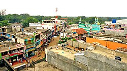 Partial aerial view of Vavuniya | |
 Vavuniya Vavuniya City  Vavuniya Vavuniya (Northern Province)  Vavuniya Vavuniya (Sri Lanka)  Vavuniya Vavuniya (Asia) | |
| Coordinates: 8°45′0″N 80°29′0″E / 8.75000°N 80.48333°E | |
| Country | Sri Lanka |
| Province | Northern |
| District | Vavuniya |
| DS Division | Vavuniya South (Tamil) |
| Government | |
| • Type | Municipal Council |
| • Chairman | Gowthaman (TNA) |
| Area | |
| • Land | 2,248.96 ha (5,557.30 acres) |
| Elevation | 200 m (700 ft) |
| Demonyms |
|
| Time zone | UTC+5:30 (Sri Lanka Standard Time Zone) |
| Website | VUC |
History edit
This city has a long history of being ruled by the Tamil kings, who built many tanks and placed Naga Sacred Guard Stones near them with inscriptions. They inherited the city from the ancient Yaka and Nagas of Sri Lanka. Later, the city became part of the Rajarata kingdom after the arrival of the Sinhalese Ancestor or Exiled Aryan (Vijaya) to Sri Lanka. The city experienced a revival of Hinduism (Shaivism) and Tamil culture after the Chola invasion and reformed as Vanni under the rule of Vanni Chieftains. However, the Cholas were soon defeated by the Pandya in Tamil Nadu, and the city fell under their control when they invaded Sri Lanka. The Pandya lost their power in Sri Lanka when the Vijayanagar Dynasty invaded and dispersed them. The Vanni Chieftains (Aaryans), who had come with the Cholas, broke away from the Pandya and formed their own Vanni nation (Not a nation but a collection of small nations), which was loyal to the central government. The Vanni resisted the Portuguese occupation but succumbed to the Dutch invasion despite the heroism of Pandara Vanniyan. The city then came under British rule when the Dutch was succeeded by British in Sri Lanka in the start of 19th century.

The British granted independence to Sri Lanka, but the Sinhalese oppression sparked a war that forced many affluent people to migrate abroad or to Vavuniya. Vavuniya is a city that was heavily affected by the war but has since recovered. Now Tamils, Muslims and Sinhalese live together without distinction. The district recently got its own university (University of Vavuniya) and there are plans to upgrade the district airport to an international airport.
Climate edit
Vavuniya has a tropical savanna climate (Köppen: As)[1] with warm to hot temperatures throughout the year and a distinct wet season from October to December. Temperatures are cooler from November to February compared to the rest of the year.
| Climate data for Vavuniya (1991–2020) | |||||||||||||
|---|---|---|---|---|---|---|---|---|---|---|---|---|---|
| Month | Jan | Feb | Mar | Apr | May | Jun | Jul | Aug | Sep | Oct | Nov | Dec | Year |
| Record high °C (°F) | 34.0 (93.2) |
36.0 (96.8) |
38.8 (101.8) |
38.9 (102.0) |
38.8 (101.8) |
38.5 (101.3) |
38.8 (101.8) |
38.4 (101.1) |
39.1 (102.4) |
38.1 (100.6) |
35.0 (95.0) |
33.0 (91.4) |
39.1 (102.4) |
| Mean daily maximum °C (°F) | 29.9 (85.8) |
31.5 (88.7) |
34.3 (93.7) |
34.9 (94.8) |
34.3 (93.7) |
34.4 (93.9) |
34.7 (94.5) |
34.6 (94.3) |
34.5 (94.1) |
32.6 (90.7) |
30.6 (87.1) |
29.6 (85.3) |
33.0 (91.4) |
| Daily mean °C (°F) | 25.5 (77.9) |
26.4 (79.5) |
28.4 (83.1) |
29.5 (85.1) |
29.7 (85.5) |
29.8 (85.6) |
29.9 (85.8) |
29.7 (85.5) |
29.6 (85.3) |
28.2 (82.8) |
26.7 (80.1) |
25.8 (78.4) |
28.3 (82.9) |
| Mean daily minimum °C (°F) | 20.9 (69.6) |
21.1 (70.0) |
22.4 (72.3) |
24.0 (75.2) |
25.0 (77.0) |
25.1 (77.2) |
24.9 (76.8) |
24.7 (76.5) |
24.4 (75.9) |
23.6 (74.5) |
22.7 (72.9) |
21.9 (71.4) |
23.4 (74.1) |
| Record low °C (°F) | 12.4 (54.3) |
10.5 (50.9) |
13.4 (56.1) |
15.3 (59.5) |
17.8 (64.0) |
18.8 (65.8) |
18.2 (64.8) |
18.2 (64.8) |
18.5 (65.3) |
16.0 (60.8) |
16.5 (61.7) |
13.0 (55.4) |
10.5 (50.9) |
| Average precipitation mm (inches) | 107.0 (4.21) |
76.2 (3.00) |
43.1 (1.70) |
123.1 (4.85) |
95.4 (3.76) |
21.1 (0.83) |
36.9 (1.45) |
63.9 (2.52) |
88.7 (3.49) |
230.0 (9.06) |
276.0 (10.87) |
249.1 (9.81) |
1,410.5 (55.53) |
| Average precipitation days (≥ 1.0 mm) | 7.1 | 4.7 | 3.9 | 9.2 | 5.8 | 2.1 | 2.6 | 4.1 | 5.7 | 13.3 | 17.1 | 12.5 | 88.0 |
| Source: NOAA[2] | |||||||||||||
Demographics edit
The total population of the Northern Province as per the statistics is 1.246 million, the lowest populous province in the country, with 606,678 males (47.3%) and 639,775 females (52.7%). The population density is 136 persons per Sq. Km as against to 346 for the whole Island. The majority in the province live in areas classified as rural (84.5%), and only 15.5% of the population live in areas classified as urban. The majority of the population i.e. 89% in the province are Sri Lankan Tamils and others are Sri Lankan Moors, Sinhalese and Indian Tamils living in the province. Most of the Sri Lankan Tamils are Hindus, and the other religious persuasions in the province are Christians, Muslims, and a small number of Buddhists. The graph here shows the difference in ethnic composition from province to district to city. While usually, the city shows a more cosmopolitan nature than the province. The Vavuniya city reflects the composition of the district quite closely, even more so than the provincial percentages.
Electoral Wards edit
| Ward Number | Area |
|---|---|
| 1 | Thandikkulam |
| 2 | Paddanichipuliyankulam |
| 3 | Pandarikulam |
| 4 | Vairavarpuliyankulam |
| 5 | Kudiyiruppu |
| 6 | Kadai Veethi |
| 7 | Moondru Muripu |
| 8 | Rambaikulam |
| 9 | Sinnaputhukkulam |
| 10 | Kovilkulam |
Transport edit
Vavuniya railway station, which is located on the Northern Line connects Kankesanthurai (the northern terminus of the line) through to Colombo.[3] During the civil war Vavuniya was the terminus of the Northern Line.Vavuniya airport, which is an air force base and a domestic airport is also located here.[4] Vavuniya is situated in the middle of the Vanni region and is the gate to northern province where people can access all the northern cities quickly.
Educational Areas edit
Vavuniya is divided into 4 educational divisions such as Vavuniya North, Vavuniya South, Vavuniya South-Sinhala division, Chettikulam. Vavuniya City comes under Vavuniya South Division
See also edit
- Vipulanantha College
- Nedunkerny
- Pandarikulam
- Nelukkulam
- Vavuniya kulam
- Vavuniya Tamil Madhya Maha Vidyalayam
- Rambaikulam Girls' Maha Vidyalayam
- Rambaikulam
- Rambaikulam SriGanavairavar kovil
References edit
- ^ "Table 1 Overview of the Köppen-Geiger climate classes including the defining criteria". Nature: Scientific Data. 23 October 2023.
- ^ "World Meteorological Organization Climate Normals for 1991-2020 — Vavuniya". National Oceanic and Atmospheric Administration. Retrieved January 20, 2024.
- ^ "Northern Line". railway.gov.
- ^ "VCCV VAVUNIYA".