


Summary
17 Avenue SW is a major east–west arterial road in the southwest quadrant of the city of Calgary, Alberta.
| Length | 12.5 km (7.8 mi)[1] |
|---|---|
| Location | Calgary, Alberta |
| East end | Macleod Trail |
| Major junctions | 14 Street SW Crowchild Trail 37 Street SW Sarcee Trail |
| West end | 101 Street SW (Calgary city limits) |
Between the Calgary Stampede Grounds and 14 Street SW, it is a commercial street—with bars, restaurants, nightclubs, and shops—which has been designated a Business Revitalization Zone, officially named 17th Ave Retail and Entertainment District.[2]
From 14th Street to Sarcee Trail, it is flanked by a mix of residential and commercial space, with small strip malls, a retirement home,[3] and denser commercial developments in the Westbrook Mall area. West of Sarcee Trail, it runs through suburban neighbourhoods and acreages, by Rundle College and Westside Recreation Centre.
The west extension of the C-Train light rail transit system runs along 17 Avenue west of 33 Street SW, as does the rapid bus transit.
Red Mile edit
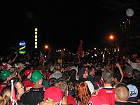
17th Avenue was nicknamed the "Red Mile" in 2004 during the playoff run of Calgary's NHL team, the Calgary Flames. During this time, it was not uncommon to see over 100,000 fans crowding the street and its bars and pubs on game nights.[citation needed]. The block has become the unofficial gathering place for Calgary Flames fans, with many celebrating in the street during their last playoff run in 2015.[4] The street also "dead-ends" at the Stampede Grounds on its east side and is thus central to the party-like atmosphere that overtakes the city during the Calgary Stampede festival.[citation needed]
Major intersections edit
From east to west. The entire route is in Calgary.
| km[1] | mi | Destinations | Notes | ||
|---|---|---|---|---|---|
| 0.0 | 0.0 | Stampede Park | Extension into Stampede Park under construction | ||
| 0.0 | 0.0 | Macleod Trail | One-way, northbound; near | ||
| 0.2 | 0.12 | 1 Street SE (to Macleod Trail south) | One-way, southbound | ||
| 0.4 | 0.25 | Centre Street S | |||
| 0.9 | 0.56 | 4 Street SW | |||
| 1.1 | 0.68 | 5 Street SW | |||
| 1.6 | 0.99 | 8 Street SW | |||
| 2.5 | 1.6 | 14 Street SW | |||
| 3.7 | 2.3 | Richmond Road (to Crowchild Trail north) | Functions as ramps for Crowchild Trail partial cloverleaf interchange | ||
| 4.1 | 2.5 | 24 Street SW (to Crowchild Trail south) | |||
| 5.4 | 3.4 | 33 Street SW | Access to | ||
| 5.8 | 3.6 | 37 Street SW | |||
| 6.6 | 4.1 | 45 Street SW | |||
| 7.3– 7.6 | 4.5– 4.7 | Sarcee Trail | Partial cloverleaf interchange | ||
| 7.9 | 4.9 | Sirroco Drive / Costello Boulevard | |||
| 9.2 | 5.7 | 69 Street SW | |||
| 10.9 | 6.8 | 85 Street SW | |||
| 12.4 | 7.7 | Interchange; roadway continues west | |||
| 1.000 mi = 1.609 km; 1.000 km = 0.621 mi | |||||
See also edit
References edit
- ^ a b Google (May 12, 2017). "17 Avenue SW in Calgary, AB" (Map). Google Maps. Google. Retrieved May 12, 2017.
- ^ "17th Ave SW – Retail & Entertainment District". Retrieved May 12, 2017.
- ^ "The Manor Village At Signature Park". Comfort Life. Our Kids Media. Retrieved 15 December 2015.
- ^ Markusoff, Jason (25 April 2015). "How 17 Avenue Has Changed But Red Mile Parties On". Calgary Herald. Post Media. Retrieved 15 December 2015.
External links edit
17th Ave Business Directory
17th Ave Retail & Entertainment District