


Summary
The 2006 Kīholo Bay earthquake occurred on October 15 at 07:07:49 local time with a magnitude of 6.7 and a maximum Mercalli intensity of VIII (Severe). The shock was centered 21 kilometers (13 mi) southwest of Puakō and 21 km (13 mi) north of Kailua-Kona, Hawaiʻi, just offshore of the Kona Airport, at a depth of 38.2 km (23.7 mi). It produced several aftershocks, including one that measured a magnitude of 6.1 seven minutes after the main shock. The Pacific Tsunami Warning Center measured a nondestructive tsunami of 4 in (100 mm) on the coast of the Big Island.[4]
 Hilo Honolulu | |
| UTC time | 2006-10-15 17:07:49 |
|---|---|
| ISC event | 11122134 |
| USGS-ANSS | ComCat |
| Local date | October 15, 2006 |
| Local time | 07:07:49 Hawaii Standard Time |
| Magnitude | 6.7 Md[1] |
| Depth | 38.2 kilometers (24 mi)[1] |
| Epicenter | 19°52′37″N 155°56′06″W / 19.877°N 155.935°W[1] |
| Type | Oblique-normal[2] |
| Areas affected | Hawaii, United States |
| Max. intensity | MMI VIII (Severe) |
| Tsunami | Yes |
| Aftershocks | 6.1 Mw Oct 15 at 17:14 UTC[1] |
| Casualties | Several injured[2][3] |
Tectonic setting edit
The island of Hawaii is affected by earthquakes related to three main causes. Some are associated with the movement of magma and tend to be shallow focus (less than 5 km (3.1 mi) depth). The largest earthquakes are those caused by overall gravitational spreading of the volcano, whether within the volcano's flanks or at the base of the volcanic pile. They tend to have focal depths in the range 5 to 13 km (3.1 to 8.1 mi). The final group of earthquakes are those caused by flexure of the oceanic lithosphere underlying the island as a result of loading by the volcano. The type of stresses within the flexing lithosphere depends on depth relative to the neutral surface, with radial compression and associated tangential tension below about 22 km (14 mi) and radial tension and tangential compression above that level. Earthquakes of this type can have focal depths as deep as 60 km (37 mi).[5]
Earthquake edit
The earthquake had a hypocentral depth of 38.2 km (23.7 mi) and a focal mechanism of normal faulting. The depth shows that it was in the mantle lithosphere, beneath the neutral surface with a mechanism consistent with tangential tension. The largest aftershock was significantly shallower at 18 km (11 mi) and had a focal mechanism of reverse faulting. The depth and mechanism are consistent with tangential compression above the neutral surface.[5]
Modified Mercalli Intensities were VII–VIII (Very strong–Severe) on the western side of the island of Hawaii, and VI (Strong) on the eastern side of Maui. Intensity V (Moderate) shaking was felt all the way to Oʻahu, where patches of moderate damage were reported.[6] The earthquake caused property damage, injuries, landslides, power outages, and airport delays and closures.[4]Governor Linda Lingle issued a disaster declaration for the entire state.[7][8]
Damage edit

The most severe damage caused by the earthquake was focused on the north and western sides of the island of Hawaii. Damage was also quite heavy on the eastern side of Maui, and minor damage spread all the way out to western Oʻahu, 170 miles (270 km) away from the earthquake's epicenter. On the Big Island, many houses had large cracks and broken windows, and at least 61 buildings were destroyed and red-tagged by officials. Almost all houses in west Hawaii reported extensive internal damage but most avoided significant structural damage, the reason being that most of the buildings in the area around the epicenter of the earthquake have been built in the last few decades and are well constructed. Even so, over $200 million in damage occurred.[9]
The largest and most luxurious hotels on the Island of Hawaii also happened to be clustered within ten miles (16 km) of the earthquake's epicenter along the Kohala coast. The 1965 Mauna Kea Beach Hotel had its entire south end collapse, and the hotel's top floor was considered "destroyed." The hotel closed on December 1 after a month-long inspection revealed that the building was unsafe and in danger of collapse. After a $150 million renovation, the hotel had a soft reopening on December 20, 2008, and officially reopened in March 2009.[10] The Hapuna Beach Prince Hotel was temporarily evacuated after the earthquake due to structural damage, broken glass and flooding caused by broken water pipes. The Surety Kohala Corporation assessed the structural integrity to their Kohala Ditch, which functioned as a tourist attraction for 10 years.
Many roads and bridges collapsed or had deep cracks, and clean-up crews had to work for days to remove debris from the countless landslides. Many landmarks on the island were greatly affected. The Kalahikiola Congregational Church in Kohala was destroyed due to the collapse of the church's stone walls; the Hawi smoke stack, a relic of the old sugarcane trade, completely collapsed as well. The Hulihee Palace in Kailua Kona suffered extensive structural damage.[11] Another popular tourist area, Kealakekua Bay, home of the white monument to Captain James Cook, was swept over by massive landslides that caused the entire bay and its surrounding areas to momentarily disappear in a thick cloud of brown dust.[12]

Mauna Kea Observatory edit
During the earthquake and aftershocks, a number of the telescopes at the Mauna Kea Observatories sustained minor damage, primarily Kecks 1 and 2 at the W. M. Keck Observatory, and the Canada–France–Hawaii Telescope (CFHT).[13] The CFHT was operational and back online as of October 19,[14] but the Kecks were not restored to full operation until February 28, 2007.[15]
Blackouts edit
Power plants on Maui and the Big Island automatically shut off power to prevent damage, and generators tripped on Oahu, causing overloads in the electrical grid.[16] The Oahu power outages lasted 14 hours in some locations; only half of Hawaiian Electric Company's (HECO) Oahu customers had power restored before 9 pm, while outages generally lasted to about 5 pm on Maui and Hawaii. Power was restored to all HECO circuits by 1:55 am; however, there were isolated blackouts due to local problems, such as blown fuses. Power in Laie and Kahuku was not restored until 3 am. In Honolulu and Kahe, HECO generators shut down, and other generators tried to compensate, resulting in uneven loads on Oahu's electrical network and causing the system to shut down to prevent damage.[17]
Images edit
-
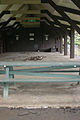 Keokea Beach Park pavilion
 -
 Hulihee Palace South wall, January 2007
 -
 Earthquake damage at the Hulihee Palace in January 2007


See also edit
References edit
- ^ a b c d "M 6.7 - Hawaii region, Hawaii". USGS. Retrieved October 13, 2020.
- ^ a b USGS (September 4, 2009), PAGER-CAT Earthquake Catalog, Version 2008_06.1, United States Geological Survey, archived from the original on March 13, 2020
- ^ "Hawaiian: 'We were rocking and rolling'". CNN. October 15, 2006. Archived from the original on February 20, 2007. Retrieved October 5, 2007.
- ^ a b "Strong Quake Rocks Hawaii". Local News. Maui Weekly. October 19, 2006. Archived from the original on September 28, 2007. Retrieved October 5, 2007.
- ^ a b Klein, F.W. (2016). "Lithospheric flexure under the Hawaiian volcanic load: Internal stresses and a broken plate revealed by earthquakes". Journal of Geophysical Research: Solid Earth. 121 (4): 2400–2428. Bibcode:2016JGRB..121.2400K. doi:10.1002/2015JB012746.
- ^ "USGS Community Internet Intensity Maps". USGS. October 15, 2007. Archived from the original on October 5, 2007. Retrieved October 5, 2007.
- ^ "Disaster declared as quake hits Hawaii". China Daily. Associated Press. October 16, 2006. Archived from the original on June 23, 2013. Retrieved January 26, 2013.
- ^ "Hawaiian historic site damaged, but blessed". Hawaii travel. Associated Press. October 24, 2006. Retrieved October 5, 2007.
- ^ "Hawaii County Cuts Red Tape for Big Island Repairs". Associated Press. October 27, 2006. Retrieved October 5, 2007.
- ^ Paiva, Derek (November 17, 2008). "Mauna Kea Beach Hotel announces new reopening date". Hawaii Magazine. Retrieved February 25, 2019.
- ^ Hawaiian Historic Site Damaged..., Associated Press, accessed November 3, 2006
- ^ Continuing Landslides lead to closures and Kealakekua Bay Archived April 5, 2008, at the Wayback Machine, Associated Press, accessed November 3, 2006
- ^ McAvoy, Audrey (October 19, 2006). "Hawaii quake damages special telescopes". The Washington Post.
- ^ "15 October 2006 Earthquake Aftermath at CFHT". University of Hawaiʻi. January 11, 2007. Retrieved October 5, 2007.
- ^ "Earthquake Update from W. M. Keck Observatory". W. M. Keck Observatory. February 28, 2007. Archived from the original on September 27, 2007. Retrieved October 5, 2007.
- ^ Reyes, B.J. (October 16, 2006). "Outages hit Oahu hardest". Honolulu Star-Bulletin. Archived from the original on November 14, 2007. Retrieved October 5, 2007.
- ^ Reyes, B.J. (October 17, 2006). "Outage stirs anger". Honolulu Star-Bulletin. Archived from the original on December 2, 2007. Retrieved October 5, 2007.
Sources edit
- EERI (2006), Preliminary Observations on the Hawai'i Earthquakes of October 15, 2006 (PDF), EERI Special Earthquake Report, Earthquake Engineering Research Institute
External links edit
- 6.7 magnitude quake shakes Hawaii
- Report on the declaration of a state of emergency – NBC News
- ISC (2014), ISC-GEM Global Instrumental Earthquake Catalogue (1900–2009), Version 1.05, International Seismological Centre
- Historic Palace Damaged, but Blessed – NBC News
- Lessons learned from the 2006 Kiholo Bay earthquakes – West Hawaii Today
- Continued Rumblings of the 2006 Kiholo Bay Earthquake – United States Geological Survey
- The International Seismological Centre has a bibliography and/or authoritative data for this event.