


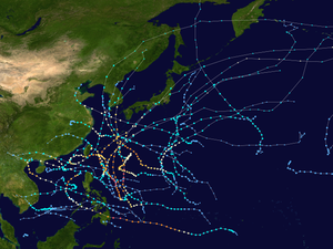
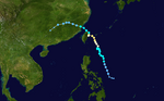
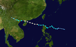
Summary
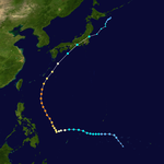
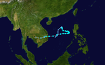
The 2012 Pacific typhoon season was a slightly above average season that produced 25 named storms, fourteen typhoons, and four intense typhoons. It was a destructive and the second consecutive year to be the deadliest season, primarily due to Typhoon Bopha which killed 1,901 people in the Philippines. It was an event in the annual cycle of tropical cyclone formation, in which tropical cyclones form in the western Pacific Ocean. The season ran throughout 2012, though most tropical cyclones typically develop between May and October. The season's first named storm, Pakhar, developed on March 28, while the season's last named storm, Wukong, dissipated on December 29. The season's first typhoon, Guchol, reached typhoon status on June 15, and became the first super typhoon of the year on June 17.
| 2012 Pacific typhoon season | |
|---|---|
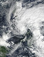
 Season summary map | |
| Seasonal boundaries | |
| First system formed | January 13, 2012 |
| Last system dissipated | December 29, 2012 |
| Strongest storm | |
| Name | Sanba |
| • Maximum winds | 205 km/h (125 mph) (10-minute sustained) |
| • Lowest pressure | 900 hPa (mbar) |
| Seasonal statistics | |
| Total depressions | 34 |
| Total storms | 25 |
| Typhoons | 14 |
| Super typhoons | 4 (unofficial) |
| Total fatalities | 2,487 total |
| Total damage | $20.79 billion (2012 USD) (Fifth-costliest Pacific typhoon season on record) |
| Related articles | |
The scope of this article is limited to the Pacific Ocean, to the north of the equator between 100°E and the 180th meridian. Within the northwestern Pacific Ocean, there are two separate agencies that assign names to tropical cyclones, which can often result in a cyclone having two names. The Japan Meteorological Agency (JMA) will name a tropical cyclone should it be judged to have 10-minute sustained wind speeds of at least 65 km/h (40 mph) anywhere in the basin. PAGASA assigns unofficial names to tropical cyclones which move into or form as a tropical depression in their area of responsibility, located between 115°E–135°E and between 5°N–25°N, regardless of whether or not a tropical cyclone has already been given a name by the JMA. Tropical depressions that are monitored by the United States' Joint Typhoon Warning Center (JTWC) are given a numerical designation with a "W" suffix.
Seasonal forecasts edit
| TSR forecasts Date |
Tropical storms |
Total Typhoons |
Intense TCs |
ACE | Ref |
|---|---|---|---|---|---|
| Average (1965–2011) | 26.2 | 16.3 | 8.4 | 295 | [1] |
| April 13, 2012 | 25.5 | 15.6 | 7.3 | 262 | [2] |
| May 5, 2012 | 25.5 | 15.6 | 8.5 | 300 | [1] |
| July 9, 2012 | 26.8 | 16.7 | 9.2 | 324 | [3] |
| August 6, 2012 | 27.4 | 17.4 | 9.3 | 327 | [4] |
| Other forecasts Date |
Forecast Center |
Period | Systems | Ref | |
| June 30, 2012 | CWB | January 1 – December 31 | 23–26 tropical storms | [5] | |
| July 2012 | PAGASA | July — September | 7–10 tropical cyclones | [6] | |
| July 2012 | PAGASA | October — December | 4–7 tropical cyclones | [6] | |
| Forecast Center |
Tropical cyclones |
Tropical storms |
Typhoons | Ref | |
| Actual activity: | JMA | 34 | 25 | 14 | |
| Actual activity: | JTWC | 27 | 25 | 16 | |
| Actual activity: | PAGASA | 17 | 16 | 9 | |
During each season, several national meteorological services and scientific agencies forecast how many tropical cyclones, tropical storms, and typhoons will form during a season and/or how many tropical cyclones will affect a particular country.[1] These agencies include the Tropical Storm Risk (TSR) Consortium of the University College London, Philippine Atmospheric, Geophysical and Astronomical Services Administration (PAGASA) and the Taiwan's Central Weather Bureau.[2][5] During previous seasons the Guy Carpenter Asia-Pacific Climate Impact Centre also issued forecasts, however they did not issue a forecast this year as it had been overestimating how many tropical cyclones would develop during the last few seasons.[7]
On March 20, the Hong Kong Observatory predicted that the typhoon season in Hong Kong, would start in June or slightly earlier, with 5–8 tropical cyclones passing within 500 km (310 mi) of the territory.[8] The TSR Consortium subsequently released their initial forecast of the season on April 11, and predicted that the basin would see activity about 10% below the 1965–2011 average, with 25.5 tropical storms, 15.6 typhoons, 7.3 "intense" typhoons and an ACE index of about 262 units.[nb 1] In late April, the China Meteorological Administration's Shanghai Typhoon Institute (CMA-STI) predicted that between 22 and 25 tropical storms would develop within the basin during the year.[3] On May 5, after a new forecast model had become available, TSR predicted that the season would now be near-normal as a new forecast model had become available as a result they raised their forecast for the number of intense typhoons to 8.5 and the ACE Index to 300 units.[1] On May 21, the Thai Meteorological Department predicted that 1-2 tropical storms would affect Thailand during 2012. They predicted that 1 would move through Vietnam and affect Upper Thailand, during August or September, while the other one was expected to move through Southern Thailand during October or November.[9]
In late June after six typhoons had formed Taiwan's Central Weather Bureau predicted that the season, would be near or below its average of 25.7 with 23 – 26 tropical storms occurring over the basin during 2012.[5] Between three and five of the systems were predicted to affect Taiwan compared to an average of around 3.6.[5] Within its July forecast update TSR increased its forecast and now predicted that the basin would see activity about 10% above the 1965–2011 average with 26.8 tropical storms, 16.7 typhoons, 9.2 "intense" typhoons and an ACE index of about 324 units.[3] This increase was attributed to the sea surface temperatures being expected to be warmer than previously thought.[3] Within its July — December seasonal climate outlook, PAGASA predicted that 7 — 10 tropical cyclones were likely to develop within or enter the Philippine area of responsibility between July and September, while 4 — 7 were predicted to occur between October and December.[6] On August 6, TSR tweaked its forecast but still expected activity to be 10% above the 1965–2011 average with 27.4 tropical storms, 17.4 typhoons, 9.3 "intense" typhoons and an ACE index of about 327 units.[4]
Season summary edit

| Rank | Total damages | Season |
|---|---|---|
| 1 | ≥ $38.96 billion | 2019 |
| 2 | ≥ $37 billion | 2023 |
| 3 | ≥ $31.54 billion | 2018 |
| 4 | ≥ $26.41 billion | 2013 |
| 5 | ≥ $20.79 billion | 2012 |
| 6 | ≥ $18.77 billion | 2004 |
| 7 | ≥ $18.36 billion | 1999 |
| 8 | ≥ $17.69 billion | 2016 |
| 9 | ≥ $15.1 billion | 2017 |
| 10 | ≥ $14.84 billion | 2015 |
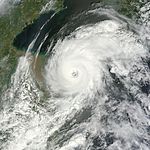
The season's first named storm, Pakhar, developed on March 28 while the last named storm, Wukong, dissipated on December 29. The season became very active between mid-July and mid-August, with nine named storms formed during the period. Vicente underwent explosive intensification and made landfall over the west Pearl River Delta as a strong typhoon. Damrey developed into a typhoon in the Yellow Sea and became the most intense tropical cyclone to make landfall north of the Yangtze River since 1949. Typhoon Haikui, although centred far away from the Philippines, killed at least 89 people in the country. Typhoon Tembin affected Taiwan twice because of its cyclonic loop.
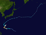
From late August to September, three very powerful typhoons, Bolaven, Sanba and Jelawat, directly hit Okinawa Island successively. In October, the remnants of Severe Tropical Storm Gaemi arrived at the Bay of Bengal and re-intensified into a deep depression before making landfall over Bangladesh. In December, Typhoon Bopha, an unusually very low-latitude but very powerful tropical cyclone, caused catastrophic damage in Mindanao in the Philippines. Bopha killed 1,901 people and cost $1.16 billion (2012 USD) in Philippines, becoming the deadliest storm worldwide in the year and the third-costliest Philippine typhoon in history, only surpassed by Typhoon Haiyan in the following season and Typhoon Rai in 2021.
Systems edit
Tropical Depression 01W edit
| Tropical depression (JMA) | |
| Tropical depression (SSHWS) | |
  | |
| Duration | February 17 – February 21 |
|---|---|
| Peak intensity | 55 km/h (35 mph) (10-min); 1004 hPa (mbar) |
Early on February 17, the JMA reported that a tropical depression had developed, about 800 km (495 mi) to the southeast of Manila on the Philippine island of Luzon.[10] During that day the depression moved westwards, before the Joint Typhoon Warning Center initiated advisories at 1500 UTC and designated the system as Tropical Depression 01W.[11] However, six hours later the JTWC issued its final advisory as vertical windshear had started to increase, and after it had found no deep convection near the systems low level circulation centre during a reassessment of the depressions low level structure.[12] Over the next few days the JMA continued to monitor the depression before it was last noted during February 20.[13]
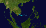
Tropical Storm Pakhar edit
| Tropical storm (JMA) | |
| Tropical storm (SSHWS) | |
  | |
| Duration | March 26 – April 2 |
|---|---|
| Peak intensity | 75 km/h (45 mph) (10-min); 986 hPa (mbar) |
On March 24, the JMA reported that a tropical depression had formed, about 250 mi (400 km) to the southwest of Manila, Philippines.[14] It later weakened to a low pressure area late on the same day.[15] Two days later, the JMA upgraded the tropical disturbance back to a tropical depression again, due to the storm reorganizing under an environment of low vertical wind shear and favorable sea surface temperatures in the South China Sea.[16][17] Early on March 28, the JTWC issued a TCFA on the tropical depression.[18] By the next day, the JMA upgraded the tropical depression to a tropical storm, and named it Pakhar.[19] The JTWC subsequently started issuing advisories on the storm, as the storm's convection had completely wrapped around the circulation center.[20] The JTWC later upgraded Pakhar into a tropical storm.[21]
Early on March 30, the JTWC upgraded Pakhar to a Category 1 typhoon, as a banding eye formed; post-analysis later showed that Pakhar didn't reach typhoon intensity.[22][23] Because of land interaction and colder sea surface temperatures, Pakhar weakened to a tropical storm by the next day.[24] On April 1, Pakhar made landfall near Vũng Tàu, Vietnam.[25] As it weakened into a tropical depression, the JMA issued their final advisory by the next day.[26] The system was last noted over Cambodia that same day.[27]
Although Pakhar did not affect the Philippines as a tropical cyclone, its precursor produced heavy rains across part of the nation. Flooding occurred in different parts of central and southern Luzon, and the northern Visayas region.[28] In Basud, Camarines Norte, 128 families had to be evacuated due to flash flooding. A few landslides resulted from the rains, damaging or destroying a few homes. Throughout the affected region, five people were killed and three others were listed as missing.[29] In Vietnam, ten people were killed and several others were injured due to flash flooding and high winds. The hardest hit area was Khánh Hòa Province where the storm made landfall. About 4,400 homes were damaged in the region by the storm and thousands of acres of rice paddy were flooded.[30] In Ho Chi Minh City, officials reported that 600 homes and schools were destroyed.[31] Total damage were finalized at ₫1.12 trillion (US$53.9 million).[32] The remnants of the system brought rains to parts of Cambodia, Laos, and Thailand.[30]
Severe Tropical Storm Sanvu edit
| Severe tropical storm (JMA) | |
| Category 1 typhoon (SSHWS) | |
  | |
| Duration | May 20 – May 27 |
|---|---|
| Peak intensity | 110 km/h (70 mph) (10-min); 975 hPa (mbar) |
On May 18, the JTWC started to monitor an area of convection approximately 95 nmi (175 km) to the north-northwest of Chuuk. At the time, it had a developing low-level circulation center with deep convection, and was under an environment of low vertical wind shear and good divergence aloft.[33] As it moved northwestwards, it continued to organize, prompting the JTWC to issue a TCFA two days later.[34][35] The JMA subsequently upgraded the system to a tropical depression on May 21.[36] The JTWC later followed suit, designating the depression as 03W.[37] The system then intensified to a tropical storm late on the same day, with the JMA naming it as Sanvu early on May 22.[38] [39] Sanvu then continued to intensify, with deep convection building over its center.[40]
Late on the next day, the JTWC upgraded Sanvu to a category 1 typhoon, as an eye was seen on microwave imagery.[41] Late on May 24, the JMA upgraded Sanvu to a severe tropical storm.[42] Accelerating northeastward along the northwestern periphery of a subtropical ridge, the system reached its peak intensity by the next day, as its eye emerged on satellite imagery.[43][44][45] As its western quadrant got affected by a dry air entrainment on May 26, Sanvu started to weaken as it directly passed over Iwo Jima.[46] With strong vertical wind shear associated with a subtropical jet stream, along with rapidly cooling sea surface temperatures, the system continued to weaken.[47] The JTWC downgraded Sanvu to a tropical storm late on the same day, as the system's low level circulation center started to become exposed.[48] The JMA followed suit by the next day.[49] The JTWC subsequently issued their final advisory on Sanvu, as it commenced extratropical transition.[50] However, the JMA continued issuing advisories on Sanvu, until by the next day, when it fully transitioned into an extratropical cyclone.[51][52] The remnants of the system was last noted during May 30.[53]
As Sanvu strengthened into a tropical storm, tropical storm watches and warnings were issued for Guam, Rota, Tinian, and Saipan.[54] It brought tropical storm force wind gusts and rainfall between 38–51 mm (1.5–2 in) to parts of Guam and the Northern Mariana Islands. However, the only damage reported was on Guam where falling tree limbs caused an estimated $20,000 of damage to power lines.[55]
Typhoon Mawar (Ambo) edit
| Typhoon (JMA) | |
| Category 3 typhoon (SSHWS) | |
  | |
| Duration | May 31 – June 6 |
|---|---|
| Peak intensity | 140 km/h (85 mph) (10-min); 960 hPa (mbar) |
On May 29, the JTWC started to monitor a tropical disturbance that formed approximately 125 nmi (230 km) to the north of Palau. At the time, the system had a weak low-level circulation center, and was under an environment of low to moderate vertical wind shear and good divergence aloft.[56] As the disturbance began moving northwestwards, it started to organize, with deep convection building along its developing center.[57] Late on the next day, the system's convection became significantly organized, prompting the JTWC to issue a TCFA.[58] By May 31, the JMA had upgraded the system to a tropical depression.[59] The PAGASA followed suit and started issuing advisories on the system, assigning its local name Ambo.[60] Late on the same day, the JTWC began issuing advisories on the system as it continued to consolidate its center, designating it as 04W.[61] By the next day, Ambo intensified into a tropical storm, with the JMA assigning its international name Mawar.[62][63]
With warm sea surface temperatures and decreasing wind shear, Mawar developed a central dense overcast.[64] This led to the JMA upgrading Mawar to a severe tropical storm on June 2.[65] The JTWC subsequently upgraded it to a Category 1 typhoon as a developing eye feature was seen on microwave imagery.[66] Turning northeastward as a mid-latitude trough weakened the subtropical ridge to the northeast, Mawar further intensified into a Category 2 typhoon early on the next day, as a ragged eye became visible on satellite imagery.[67] The JMA followed suit and upgraded Mawar to a typhoon later that same day.[68] By June 4, Mawar reached its peak intensity,[69][70] before it started to weaken due to the mid-latitudes impacting the system's overall structure, with its eye breaking down into tight spiral banding, prompting the JTWC to downgrade the system to a category 2 typhoon.[71] On the next day, the PAGASA issued their final advisory on Mawar, as it was exiting the Philippine Area of Responsibility.[72] Mawar further weakened into a category 1 typhoon as its low-level circulation center widened, and was entering a hostile environment due to its interaction with the jet stream.[73] The JMA subsequently downgraded Mawar to a severe tropical storm,[74] as it commenced its extratropical transition.[75] Late on the same day, the JTWC issued their final advisory on Mawar, as it was deeply embedded in the baroclinic zone and its low-level circulation center had decoupled behind its convection.[76] On June 6, Mawar fully became an extratropical cyclone, and the JMA issued their final advisory on the system.[77] The system was last noted east of the Kamchatka Peninsula on June 13.[78]
Mawar brought torrential rain to parts of the Philippines including the Bicol Region while enhancing the southwest monsoon which triggered delays and cancelled of air flights. In Bicol region, more than 332 passengers were stranded at ports due to Mawar.[79] Different domestic and international flights were forced to divert at Clark Air Base rather than NAIA due to bad weather. Some other flights were also cancelled.[80][81] At least three were reported dead due to rains brought by Mawar.[82]
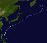
Typhoon Guchol (Butchoy) edit
| Very strong typhoon (JMA) | |
| Category 4 super typhoon (SSHWS) | |
  | |
| Duration | June 10 – June 19 |
|---|---|
| Peak intensity | 185 km/h (115 mph) (10-min); 930 hPa (mbar) |
Late on June 7, a tropical disturbance formed south-southeast of Pohnpei.[83] By the next day, the Joint Typhoon Warning Center (JTWC) issued a Tropical Cyclone Formation Alert on the system, but cancelled it late on June 9.[84][85] The JMA upgraded the low-pressure area to a tropical depression early on June 11, with the JTWC subsequently following suit.[86][87] Early on the next day, the JTWC upgraded the system to a tropical storm, and later the JMA also upgraded it to a tropical storm and named it Guchol.[88][89] Early on June 14, the JMA upgraded Guchol to a severe tropical storm, and the PAGASA assigned the local name Butchoy on the system as it entered the Philippine Area of Responsibility.[90][91] Later that day, the JTWC upgraded Guchol to a category 1 typhoon, as convection started to organize.[92] It continued to intensify into a category 2 typhoon on June 15, as it became better organized and started to develop more convection.[93] As Guchol went through rapid intensification with a well defined eye on June 16, the JMA upgraded it to a typhoon early that day, and the JTWC upgraded it further to a category 3 typhoon, and later a category 4 super typhoon.[94][95][96] Guchol reached peak intensity late on June 17,[97] before it began to undergo an eyewall replacement cycle as the storm weakened under moderate vertical wind shear on June 18,[98] and later started its extratropical transition. The JTWC downgraded Guchol to a tropical storm on June 19, as it made landfall over Kii Peninsula in Japan.[99] Later that day, the JMA downgraded Guchol to a severe tropical storm, as it traversed Japan.[100] On June 20, the JMA issued their last advisories on Guchol, as it fully transitioned into an extratropical cyclone northeast of Japan.[101]
Between June 14 and 18, Guchol enhanced the southwestern monsoon over the Philippines, resulting in widespread rains. However, the effects of these rains were limited and only one fatality took place.[102] In Japan, airlines cancelled 420 domestic and international flights because of the strong winds, affecting 32,600 passengers. The town of Nachikatsuura, some 400 kilometres southwest of Tokyo, ordered nearly 1,600 residents to evacuate, warning of the danger of landslides brought on by heavy rain, media reports said. At least two people were killed and eighty others were injured across the country. Total economic losses were estimated in excess of ¥8 billion (US$100 million).[103]
Severe Tropical Storm Talim (Carina) edit
| Severe tropical storm (JMA) | |
| Tropical storm (SSHWS) | |
  | |
| Duration | June 16 – June 20 |
|---|---|
| Peak intensity | 95 km/h (60 mph) (10-min); 985 hPa (mbar) |
On June 16, the JMA started to issue advisories on a tropical depression, located to the east of Hainan, China.[104] By the next day, the JTWC issued a TCFA on the system, as deep convection was consolidating to its low-level circulation center.[105] The JMA later upgraded the system to a tropical storm, naming it Talim.[106] The JTWC subsequently started to issue advisories on Talim, as convection was quickly developing northward into the center.[107] On June 18, the JTWC upgraded Talim to a tropical storm, as a scatterometer pass supported gale-force winds on the southern periphery of the system.[108] However, as it moved east-northeastward, moderate to strong wind shear caused its deep convection to be displaced to the south, leaving its center partially exposed.[109] By the next day, the system's center became fully exposed due to the continued effects of high wind shear.[110] Despite of that, Talim strengthened into a severe tropical storm.[111] On June 20, the JMA downgraded Talim to a tropical storm, as the system tracked towards the Taiwan Strait.[112][113] The PAGASA later assigned the local name Carina on the system, as it entered the Philippine Area of Responsibility.[114] Late on June 20, both the JMA and the JTWC downgraded Talim to a tropical depression, as land interaction significantly weakened the system's organization.[115][116] The JTWC issued their final advisory on the system by the next day.[117]
In Hong Kong, the Strong Wind Signal No.3 was raised as Talim moved near the territory. Many fallen trees were reported, along with a yacht that ran aground due to its anchor being broken.[118] Throughout China, 1 people were killed and total economic losses were counted to be CNY2.25 billion (US$354 million).[119]
Tropical Storm Doksuri (Dindo) edit
| Tropical storm (JMA) | |
| Tropical storm (SSHWS) | |
  | |
| Duration | June 25 – June 30 |
|---|---|
| Peak intensity | 75 km/h (45 mph) (10-min); 992 hPa (mbar) |
On June 25, the JMA started to monitor a tropical depression that had developed, within the monsoon trough about 1,585 km (985 mi) to the southeast of Manila, Philippines.[120][121] During that day the depression moved north-westwards and consolidated further before during the next day, PAGASA started to monitor it as Tropical Depression Dindo.[122][123] Later that day, the JMA upgraded the system to a tropical storm and named it Doksuri,[124] and the JTWC upgraded Doksuri to a tropical depression.[125] Late on the same day, the JTWC upgraded Doksuri to a tropical storm.[126] On June 27, Doksuri's low-level circulation center became exposed due to moderate easterly wind shear.[127] On June 28, the JTWC downgraded Doksuri to a tropical depression, as the system's exposed circulation center began to undergo an unusual circulation center replacement cycle, which involves a circulation center to be replaced by another new circulation center.[128] Late on June 29, Doksuri made landfall over Nanshui, Zhuhai, Guangdong, China.[129] During June 30, the JMA reported that Doksuri had weakened into a tropical depression, before reporting that the depression had dissipated later that day.[130] In Macau, the storm caused minor roof damage.[131]
Severe Tropical Storm Khanun (Enteng) edit
| Severe tropical storm (JMA) | |
| Tropical storm (SSHWS) | |
  | |
| Duration | July 14 – July 19 |
|---|---|
| Peak intensity | 95 km/h (60 mph) (10-min); 985 hPa (mbar) |
On July 14, the JTWC reported that a tropical disturbance had formed to the north-northeast of Guam.[132] As the low's convection started to organize, the JMA to upgraded the system to a tropical depression late on the same day.[133][134] Early on the next day, the JTWC issued a TCFA on the system, and it upgraded the system to a tropical depression later that day.[135][136] On July 16, the JMA upgraded the system to a tropical storm and named it Khanun.[137] Later on the same day, the JTWC upgraded Khanun to a tropical storm; also, the PAGASA named it Enteng as the system briefly passed the corner of the Philippine Area of Responsibility.[138][139] Late on July 17, the JMA upgraded Khanun to a severe tropical storm.[140] On July 18, the JMA downgraded Khanun to a tropical storm, before the system passed over Jeju.[141] Khanun weakened into a tropical depression near the Korean Demilitarized Zone early on July 19,[142][143] and it became post-tropical late on the same day.[144]
The storm killed at least one person in South Korea,[145] while in North Korea, state-run media reported that at least seven people were killed in Kangwon Province, with an eighth fatality reported elsewhere. It said the storm caused significant damage, destroying 650 dwelling houses, 30 public buildings, railways, roads, bridges, and various systems. The flooding also inundated nearly 3,870 homes, leaving more than 16,250 people homeless.[146] On July 29, the North Korean government dramatically raised the death toll in the country to 88, with an additional 134 injured. The biggest loss of human life was in two counties of South Pyongan Province. At least 63,000 were made homeless by the flooding, while more than 30,000 hectares of land for growing crops were submerged and will add to growing fears of another looming famine in the country. Three hundred public buildings and 60 factories were damaged during the storm.[147]
Typhoon Vicente (Ferdie) edit
| Typhoon (JMA) | |
| Category 4 typhoon (SSHWS) | |
  | |
| Duration | July 18 – July 25 |
|---|---|
| Peak intensity | 150 km/h (90 mph) (10-min); 950 hPa (mbar) |
Originally Khanun's large area of convention on July 16, the JMA upgraded the system to a tropical depression on July 18.[148] On July 20, the JTWC issued a TCFA on the system;[149] soon, the PAGASA upgraded it to a tropical depression and named it Ferdie.[150] The JTWC also upgraded the system to a tropical depression late on the same day.[151] After the system moved into the South China Sea on July 21, the JMA upgraded the system to a tropical storm and named it Vicente,[152] so did the JTWC.[153]
On July 23, due to weak vertical wind shear and high sea surface temperature, Vicente started to undergo an explosive intensification prompting the JMA to upgrade Vicente to a typhoon, and the JTWC upgraded Vicente to a category 4 typhoon later.[154] At 16:45 UTC, the HKO issued the Hurricane Signal, No. 10, the first since Typhoon York in 1999.[155] Later, Typhoon Vicente made landfall over Taishan in Guangdong, China.[156] Due to land interaction, the JMA downgraded Vicente to a severe tropical storm early on July 24, and the JTWC downgraded Vicente to a category 3 typhoon.[157][158] Late on the same day, the JMA downgraded Vicente to a tropical depression.[159]
Typhoon Saola (Gener) edit
| Typhoon (JMA) | |
| Category 2 typhoon (SSHWS) | |
  | |
| Duration | July 26 – August 5 |
|---|---|
| Peak intensity | 130 km/h (80 mph) (10-min); 960 hPa (mbar) |
On July 26, the JMA reported that a tropical depression had developed within an area of strong vertical windshear in the monsoon trough about 1,000 kilometres (620 mi) to the southeast of Manila in the Philippines.[160][161] Early on July 28, the JTWC upgraded the system to a tropical depression, whilst the JMA upgraded it to a tropical storm and named it Saola.[162][163] Soon, the PAGASA upgraded the system to a tropical depression and named it Gener.[164] Later that day, the JTWC upgraded Saola to a tropical storm.[165] Early on July 29, the JMA upgraded Saola to a severe tropical storm.[166] On July 30, the JTWC upgraded Saola to a category 1 typhoon, as it started to develop an eye-like feature,[167] but soon downgraded it to a tropical storm late on the same day.[168] By the next day, the JTWC reupgraded Saola to a Category 1 typhoon.[169] Late on the same day, the JMA upgraded Saola to a typhoon.[170] It continued to intensify the next day, reaching its peak intensity as a Category 2 typhoon.[171]
Most forecast models predicted Saola to pass near the northern coastline of Taiwan,[172] but this is defied on August 1, when Saola had made landfall on Taiwan as a Category 2 typhoon. It moved slowly inland, making a counter-clockwise loop.[173][174] As it emerged to the ocean, it weakened to a severe tropical storm on August 2.[175] Saola then returned to its northwest track and traversed Taiwan, as it weakened to a tropical storm, before emerging to the Taiwan Strait and approached China.[176][177] On August 3, it made its final landfall in China as a tropical storm, with the JTWC issuing their final advisory.[178] The JMA later followed suit, as Saola weakened to a tropical depression over Jiangxi.[179]
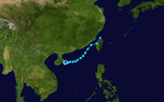
Typhoon Damrey edit
| Typhoon (JMA) | |
| Category 1 typhoon (SSHWS) | |
  | |
| Duration | July 27 – August 4 |
|---|---|
| Peak intensity | 130 km/h (80 mph) (10-min); 965 hPa (mbar) |
Originally a cold-core low, the system became a tropical disturbance southwest of Minamitorishima late on July 26. Early on July 27, the Japan Meteorological Agency (JMA) upgraded it to a tropical depression.[180] On July 28, the Joint Typhoon Warning Center (JTWC) issued a Tropical Cyclone Formation Alert on the system, before the JMA upgraded it to a tropical storm and named it Damrey.[181][182] Late on the same day, the JTWC upgraded Damrey to a tropical depression, and even upgraded it to a tropical storm on the next day.[183][184] After Damrey had drifted slowly for two days, the JMA upgraded it to a severe tropical storm northeast of Chichi-jima late on July 30, when the storm began to accelerate moving west-northwest and form a banding eye.[185] On August 1, the JTWC upgraded Damrey to a category 1 typhoon, while the system passed through the Ōsumi Islands in Japan, as it started to develop a well defined eye.[186] When Damrey drifted towards Yellow Sea on August 2, the JMA upgraded it to a typhoon.[187] Soon, Typhoon Damrey made landfall over Xiangshui County in Jiangsu, China at 13:30 UTC (21:30 CST).[188] Late on August 2, the JTWC downgraded Damrey to a tropical storm with a final warning,[189] with the JMA downgrading it to a severe tropical storm.[190] By August 3, the JMA downgraded Damrey to a tropical depression when it was located in Shandong.[191] The system then dissipated near Hebei on August 4.[192]
Typhoon Haikui edit
| Typhoon (JMA) | |
| Category 1 typhoon (SSHWS) | |
  | |
| Duration | August 1 – August 11 |
|---|---|
| Peak intensity | 120 km/h (75 mph) (10-min); 965 hPa (mbar) |
Late on July 31, a tropical disturbance formed within a large monsoon trough. On August 1, the Japan Meteorological Agency (JMA) mentioned the system as a tropical depression southeast of Iwo Jima, and the Joint Typhoon Warning Center (JTWC) issued a Tropical Cyclone Formation Alert late on the same day.[193][194] Late on August 2, the JTWC upgraded it to a tropical depression, before the JMA upgraded the system to a tropical storm and named it Haikui early on the next day.[195][196] Early on August 4, the JTWC upgraded Haikui to a tropical storm.[197] On August 5, the JMA upgraded Haikui to a severe tropical storm when it was located north-northeast of Kume Island.[198] The JTWC upgraded Haikui to a category 1 typhoon late on August 6, as it developed an eye.[199] At 12:00 UTC on August 7, the JMA upgraded Haikui to a typhoon.[200] Later, Typhoon Haikui made landfall over Xiangshan County in Zhejiang, China at 19:20 UTC (03:20 CST on August 8).[201] Early on August 8, the JMA downgraded Haikui to a severe tropical storm, when the JTWC issued the final warning.[202][203] Soon, the JMA downgraded Haikui to a tropical storm.[204] Haikui further weakened to a tropical depression on August 9, with the JMA issuing their last advisory on the system.[205]
Severe Tropical Storm Kirogi edit
| Severe tropical storm (JMA) | |
| Tropical storm (SSHWS) | |
  | |
| Duration | August 3 – August 10 |
|---|---|
| Peak intensity | 95 km/h (60 mph) (10-min); 990 hPa (mbar) |
During August 3, the JMA reported that a tropical depression had developed, about 720 km (445 mi) to the northwest of Wake Island.[206] Over the next day the system gradually developed further, before the JTWC started to monitor the system as Tropical Depression 13W, late on August 4.[207][208]
On August 5, the JTWC upgraded the system to a tropical storm.[209] Early on August 6, the JMA reported that the system had become extratropical.[210] However, the JMA designated it as a tropical storm with the name Kirogi early on August 8.[211] Early on August 9, the JTWC downgraded Kirogi to a tropical depression.[212] Later, the JMA upgraded Kirogi to a severe tropical storm, it reached its peak intensity,[213] while the JTWC upgraded it to a tropical storm again.[214] Later that day, the JTWC issued its final warning on Kirogi as it transitioned from a warm cored tropical system to a cold cored subtropical system.[215] The remnants of the system then entered the Sea of Okhotsk.[216]
Typhoon Kai-tak (Helen) edit
| Typhoon (JMA) | |
| Category 1 typhoon (SSHWS) | |
  | |
| Duration | August 12 – August 18 |
|---|---|
| Peak intensity | 120 km/h (75 mph) (10-min); 970 hPa (mbar) |
The monsoonal trough spawned a tropical disturbance early on August 10,[217] which had organizing convection and a weak circulation.[218] Early on August 12, the Japan Meteorological Agency (JMA) started tracking the system as a weak Tropical Depression with winds under 30 knots.[219] Philippine Atmospheric, Geophysical and Astronomical Services Administration (PAGASA) started issuing advisories on the system, naming it Helen.[220] That day, the JTWC also initiated advisories on Tropical Depression 14W.[221] Early on August 13, the JMA upgraded the depression to Tropical Storm Kai-tak (1213).[222] and 9 hours later the JTWC followed suit.[223] Later the same day, the JMA upgraded it to a Severe Tropical Storm.[224] On August 15, the convection increased as outflow improved, and the JTWC upgraded Kai-tak to a typhoon.[225] The storm continued towards China, with deepening convection due to decreasing wind shear.[226] However, it was only at 0000 UTC on August 16 when the JMA officially declared Kai-tak a typhoon.[227] At the same time, the PAGASA issued their last warning on Kai-tak, otherwise known as Helen, locally, as it left the Philippine area of Responsibility.[228]
On the morning of August 17, Kai-tak made landfall over the Leizhou peninsula in southern China as a typhoon.[229] Within 6 hours, Kai-tak made a second landfall over the northeast coast of Vietnam and weakened slightly to a tropical storm.[230] Later that night, the JTWC issued their final warning on the system as it weakened further and sped up inland.[231] The JMA stopped tracking the storm early the next morning, no longer considering it a tropical cyclone.[232]
Typhoon Tembin (Igme) edit
| Typhoon (JMA) | |
| Category 4 typhoon (SSHWS) | |
  | |
| Duration | August 17 – August 30 |
|---|---|
| Peak intensity | 150 km/h (90 mph) (10-min); 950 hPa (mbar) |
On August 16, a tropical disturbance formed southeast of Taiwan.[233] On August 17, the JMA mentioned it as a tropical depression, as a subtropical ridge pushed the system southwards.[234] The JTWC issued a TCFA on the system late on August 18;[235] early on the next day, the JMA upgraded it to a tropical storm and named it Tembin, and the JTWC upgraded it to a tropical depression.[236][237] Soon, the PAGASA also upgraded it to a tropical depression and named it Igme.[238] On August 20, Tembin entered a period of explosive intensification by excellent dual outflow, prompting both the JMA and the JTWC upgrading it to a typhoon.[239][240] By the end of the same day, Tembin reached its initial peak intensity as a Category 4 typhoon,[241] before it started to weaken by the next day as a TUTT cell developed over the system.[242]
On August 22, Tembin began reintensify, as an eye feature was forming once again.[243] By the next day, Tembin re-intensified into a category 3 typhoon,[244] before it made landfall over Pingtung, Taiwan later on the same day.[245] Due to land interaction, the JMA downgraded Tembin to a severe tropical storm early on August 24,[246] and the JTWC downgraded it to a tropical storm later.[247] Soon, the JTWC upgraded Tembin to a typhoon when it moved into the South China Sea.[248] Late on August 25, the JMA upgraded Tembin to a typhoon again,[249] and the system intensified into a category 2 typhoon early on the next day.[250] Afterwards, Typhoon Tembin interacted with the nearby Typhoon Bolaven.[251] Over the next few days, Tembin made a counterclockwise loop eastward,[252] moving back into the Philippine Area of Responsibility (PAR) in the process, causing more rainfall over in the Philippines.[253] Afterwards, the JTWC downgraded the system to a tropical storm late on August 27, as it turned north-northeastward.[254] The JMA soon downgraded it to a severe tropical storm by the next day.[255] On August 30, Tembin made landfall on South Korea,[256][257] and transitioned into an extratropical storm.[258]
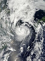
Typhoon Bolaven (Julian) edit
| Very strong typhoon (JMA) | |
| Category 4 typhoon (SSHWS) | |
  | |
| Duration | August 19 – August 29 |
|---|---|
| Peak intensity | 185 km/h (115 mph) (10-min); 910 hPa (mbar) |
Forming as a tropical depression on August 19 to the southwest of the Mariana Islands,[259] Bolaven steadily intensified as it slowly moved west-northwestward in a region favoring tropical development. The system was soon upgraded to a tropical storm less than a day after formation and further to a typhoon by August 21.[260][261] Strengthening became more gradual thereafter as Bolaven grew in size.[262] On August 24, the system attained its peak intensity with winds of 185 km/h (115 mph) and a barometric pressure of 910 mbar (hPa; 26.87 inHg). Weakening only slightly, the storm passed directly over Okinawa on August 26 as it began accelerating toward the north.[263][264][265] Steady weakening continued as Bolaven approached the Korean Peninsula and it eventually made landfall in North Korea late on August 28 before transitioning into an extratropical cyclone.[266] The remnants rapidly tracked northeastward and was last noted over the Russian Far East.[267]
Although Bolaven struck the Ryukyu Islands as a powerful typhoon, damage was less than expected. Relatively few buildings were damaged or destroyed across the region.[268] The most significant effects stemmed from heavy rains, amounting to 551.5 mm (21.71 in), that caused flash flooding and landslides.[269] One person drowned on Amami Ōshima after being swept away by a swollen river.[270] In mainland Japan, two people drowned after being swept away by rough seas.[271][272] In South Korea, 19 people were killed by the storm. Many buildings were damaged and approximately 1.9 million homes were left without power.[273][274] Losses in the country reached ₩420 billion (US$374.3 million), the majority of which was due to destroyed apple orchards.[275] Significant damage also took place in North Korea where at least 59 people were killed and 50 others were reported missing.[276] Additionally, 6,700 homes were destroyed. Offshore, nine people drowned after two Chinese vessels sank.[277] Total economic losses in China were counted to be CNY 19.82 billion (US$3.126 billion).[119]
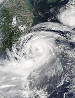
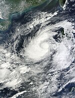
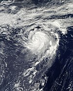
Typhoon Sanba (Karen) edit
| Violent typhoon (JMA) | |
| Category 5 super typhoon (SSHWS) | |
  | |
| Duration | September 10 – September 18 |
|---|---|
| Peak intensity | 205 km/h (125 mph) (10-min); 900 hPa (mbar) |
A low-pressure area formed east of Palau on September 9.[278] On September 10, both the JMA and the JTWC upgraded it to a tropical depression.[279][280][281] As the system entered the PAR early on September 11, the PAGASA named it Karen.[282] At the same time, the JMA upgraded the system to a tropical storm and named it Sanba, and the JTWC also upgraded it to a tropical storm later.[283] Late on September 12, Sanba began explosive intensification, prompting the JMA upgrading it to a severe tropical storm and even a typhoon later.[284][285] On September 13, the JTWC reported that Sanba rapidly strengthened into a category 5 super typhoon, the strongest since Megi in 2010.[286] By the next day, the system started to weaken as it had undergone an eyewall replacement cycle.[287] It soon ended up with a 57 kilometer-wide eye.[288] On September 17, Sanba made landfall over South Korea.[289]
In Kōchi Prefecture, Japan, 222 hectares (548 acres) of agricultural land was damaged by the storm, with losses reaching ¥50 million (US$640 thousand).[290] Throughout Okinawa, damage to agriculture, forestry, and fisheries amounted to ¥900 million (US$11.5 million).[291]
Typhoon Jelawat (Lawin) edit
| Violent typhoon (JMA) | |
| Category 5 super typhoon (SSHWS) | |
  | |
| Duration | September 20 – October 1 |
|---|---|
| Peak intensity | 205 km/h (125 mph) (10-min); 905 hPa (mbar) |
On September 18, a tropical disturbance formed to the east of Guam.[292] Late on the next day, the JTWC issued a TCFA on the system.[293] By September 20, both the JMA and the PAGASA upgraded the low-pressure area to a tropical depression, with the latter naming it as Lawin.[294][295] The JTWC subsequently followed suit and upgraded it to a tropical depression.[296] Late on the same day, the JMA upgraded the system to a tropical storm and named it Jelawat, and so did the JTWC.[297][298] Half a day later, the JMA upgraded Jelawat to a severe tropical storm.[299] Early on September 23, both the JMA and the JTWC upgraded Jelawat to a typhoon.[300][301] It started to undergo explosive intensification, becoming a category 4 typhoon in 12 hours, as it developed a small eye.[302] Late on September 24, as Jelawat developed a 19-kilometre-wide (12 mi) eye, the JTWC upgraded the system to a category 5-equivalent super typhoon.[303] By the next day, the system started its eyewall replacement cycle.[304] By September 26, it weakened to a Category 4 super typhoon as it completed the cycle,[305] with its eye becoming 74 kilometers across by the next day.[306] On September 28, it started another eyewall replacement cycle.[307] This led to the system weakening to a category 3-equivalent typhoon,[308] and a category 2-equivalent system on the next day due to cooling sea surface temperatures.[309] It further weakened to a category 1-equivalent typhoon late on the same day.[310] On September 30, the JTWC downgraded Jelawat to a tropical storm,[311] before it made landfall on Japan a few hours later.[312] The JMA downgraded Jelawat to a severe tropical storm late on the same day, with the JTWC issuing its final advisory.[313][314] The JMA further downgraded the system to a tropical storm by the next day,[315] before it fully became an extratropical cyclone six hours later.[316]
Severe Tropical Storm Ewiniar edit
| Severe tropical storm (JMA) | |
| Tropical storm (SSHWS) | |
  | |
| Duration | September 23 – September 30 |
|---|---|
| Peak intensity | 95 km/h (60 mph) (10-min); 985 hPa (mbar) |
On September 22, the JTWC reported that a low-pressure area was developing to the west of Guam, around 650 nautical miles (1,200 km) east-northeast of Typhoon Jelawat.[317] By the next day, the JMA upgraded it to a tropical depression.[318] On September 24, the JTWC upgraded the system to a tropical depression, although deep convection was displaced to the south due to moderate vertical wind shear associated with Jelawat, leaving its low-level circulation center exposed.[319][320] The center then began to consolidate, with deep convection wrapping over its eastern quadrant, prompting both the JMA and the JTWC to upgrade the system to a tropical storm, with the former naming it as Ewiniar.[321][322]
Moving north-northeastward along the periphery of the subtropical ridge, Ewiniar's center continued to be displaced from the main convection due to moderate wind shear.[323] By September 26, Ewiniar struggled to maintain its deep convection due to the continued effects of wind shear.[324] Despite that, the JMA upgraded Ewiniar into a severe tropical storm.[325] On the next day, the system reached peak intensity as it turned northward, with weakening convection wrapping to its center,[326] before it became embedded within a subtropical trough.[327] However, deep convection wrapped the system as it became quasi-stationary late on the same day,[328] before returning to a northeastward track soon after.[329] By the next day, Ewiniar's center became partially exposed, and it began to weaken.[330][331] On September 29, the JMA downgraded the system to a tropical storm, as convection was being displaced to the northeast of its center by strong vertical wind shear.[332][333] The JTWC issued their final advisory on the same day, as Ewiniar's center fully separated from its convection, and had undergone extratropical transition.[334] Ewiniar then became extratropical by the next day.[335]
Severe Tropical Storm Maliksi edit
| Severe tropical storm (JMA) | |
| Tropical storm (SSHWS) | |
  | |
| Duration | September 29 – October 4 |
|---|---|
| Peak intensity | 95 km/h (60 mph) (10-min); 985 hPa (mbar) |
On September 28, the JTWC started to monitor an area of convection approximately 80 nautical miles (150 km) to the northwest of Chuuk. At the time, it had a broad but slowly developing low-level circulation center, and was under a marginal environment of warm sea surface temperatures, weak vertical wind shear and limited poleward outflow.[336] As the system's center began to consolidate,[337] the JMA upgraded it to a tropical depression by the next day.[338] Half a day later, the JTWC issued a TCFA on the system, as its center became better defined, with convection wrapping into it,[339] before it subsequently upgraded the system to a tropical depression, designating it as 20W.[340] As the system continued to organize itself, the JMA upgraded it to a tropical storm by October 1, naming it as Maliksi.[341][342] The JTWC subsequently followed suit, although its deep convection to the southeast were yet to wrap towards its center.[343]
Moving northwestward under the southwest periphery of the subtropical ridge, Maliksi continued to improve its center by the next day, with convective banding wrapping tightly towards it.[344] However, microwave imagery showed the system had become less organized 12 hours later, with its center becoming elongated.[345] Nonetheless, the JMA upgraded Maliksi to a severe tropical storm late on the same day, as it began to improve once again.[346][347] As it turned to the northeast, deep convection from the system became isolated to the east, due to increasing wind shear and unfavorable conditions as it started transitioning to an extratropical system.[348] As a result, the JTWC issued their final advisory on Maliksi late on October 3, as convection became greatly sheared to the northeast.[349] The system then became fully extratropical by the next day.[350] The extratropical system went on to merge with a front, becoming an intense hurricane-force low on October 5, before reforming near the Aleutian Islands and dissipating near Alaska on October 11.[351]
As the system was developing near the Mariana Islands, tropical storm warnings were issued in Alamagan, Pagan and Agrihan on October 1.[352] However, as Maliksi moved northwest, the warnings were cancelled by the next day.[353]
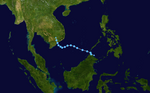
Severe Tropical Storm Gaemi (Marce) edit
| Severe tropical storm (JMA) | |
| Tropical storm (SSHWS) | |
  | |
| Duration | September 29 – October 7 |
|---|---|
| Peak intensity | 95 km/h (60 mph) (10-min); 990 hPa (mbar) |
On September 29, the JTWC started to monitor an area of convection, within a monsoon trough, approximately 325 nmi (602 km) to the southeast of Huế, Vietnam. At the time, it already had an organizing low-level circulation center, and was within a low to moderate wind shear environment.[337][354] The JMA soon upgraded it to a tropical depression.[355] As the depression became quasi-stationary, deep convection consolidated over its center, prompting the JTWC to issue a TCFA by the next day.[356] On October 1, the JMA upgraded the system into a tropical storm, naming it as Gaemi.[357] At the same time, the JTWC started issuing advisories on Gaemi as a tropical depression,[358] before subsequently upgrading it to a tropical storm, as a scatterometer pass indicated gale-force winds within the system.[359]
Within a weak steering environment, Gaemi moved southward under the influence of a near-equatorial ridge, as it continued to improve.[360] By the next day, Gaemi entered the Philippine Area of Responsibility (PAR) as deep convection continued to wrap the system, with the PAGASA assigning its local name Marce.[361][362] With a central dense overcast over the system's center,[363] the JMA upgraded Gaemi to a severe tropical storm on October 3, as it turned to the west-southwest as a building subtropical ridge to the north took command of the system's steering influence.[364][365] The JTWC originally anticipated the storm to strengthen into a typhoon under favorable conditions,[365] however, increasing easterly wind shear sheared the system's convection to the west as it turned east by the next day, with its center becoming fully exposed.[366] As a result, the JMA downgraded Gaemi to a tropical storm.[367] Returning to a westward track,[368] Gaemi remained fully exposed by October 5, and was deteriorating under the continued effects of wind shear.[369] Later that same day, it exited the PAR, with the PAGASA issuing their final advisory on the storm.[370] Gaemi then slightly reintensifed by the next day, with deep convection covering its center but most of the convection remained isolated to its west.[371] At 6:00 pm ICT (11:00 UTC), it made landfall over Phú Yên Province in Vietnam.[372] The JMA subsequently downgraded Gaemi to a tropical depression,[373] with the JTWC issuing their final advisory on the system.[374] The remnants then spawned an area of convection that developed into Depression BOB 01 in the Bay of Bengal.[375]
As Gaemi, locally known as Marce, moved near the Philippines, signal #1 warnings were issued in Bataan and Zambales.[376] The storm brought heavy rainfall, resulting in a dike partially collapsing in Occidental Mindoro and the evacuation of 5 families. 14 student-mountaineers were rescued after being trapped at Papaya River Base Camp in Mariveles, Bataan due to rains caused by Gaemi.[377] A storm surge was reported at San Antonio, Zambales in October 3, damaging 23 houses, and in Calintaan, Occidental Mindoro in October 5, damaging 28 houses. A 59-year old fisherman was found dead along the shore of Nasugbu, Batangas, after two motorbancas with 3 fishermen onboard capsized amid big waves and strong winds caused by Gaemi.[378] In Vietnam, the storm killed 5 people.[32]
Typhoon Prapiroon (Nina) edit
| Very strong typhoon (JMA) | |
| Category 3 typhoon (SSHWS) | |
  | |
| Duration | October 5 – October 19 |
|---|---|
| Peak intensity | 165 km/h (105 mph) (10-min); 940 hPa (mbar) |
On October 5, the JMA started to monitor a tropical depression that had developed about 115 km (70 mi) to the northwest of Hagåtña, Guam.[379] At the time, the depression had a consolidating low-level circulation center, and was under an environment of warm sea surface temperatures and marginal vertical wind shear.[380] With increased central convection and improving but fragmented banding, the system continued to organize, prompting the JTWC to issue a TCFA late on the next day.[381] On October 7, the JMA upgraded the tropical depression to a tropical storm, and named it Prapiroon.[382] At the same time, the JTWC started issuing advisories on Prapiroon as a tropical depression,[383] before subsequently upgrading it to a tropical storm, noting its rapid improvement with deep convective banding wrapping from the southwest to the east of the system's center.[384] Early by the next day, Prapiroon intensified to a severe tropical storm, as it continued to improve, with tightly-curved banding over its center, while moving westward along the subtropical ridge.[385][386] The PAGASA later assigned the local name Nina as the system entered the Philippine Area of Responsibility (PAR).[387]
Late on the same day, the JMA upgraded Prapiroon to a typhoon, as deep convective banding was steadily developing along its southern quadrant.[388][389] The JTWC subsequently followed suit by October 9, as an eye feature began to develop on satellite imagery.[390] On the next day, Prapiroon further intensified into a category 2-equivalent typhoon.[391] As it became quasi-stationary, due to a weak steering environment between the subtropical ridge to the northeast and a near-equatorial ridge to the southeast, Prapiroon developed an 18 nmi (33 km) eye,[392] reaching its peak intensity as a category 3-equivalent typhoon late on October 11.[393] By the next day, Prapiroon weakened to a category 2-equivalent typhoon, as its eye became ragged, along with warming cloud tops, while it was steered to the east-northeast by the near-equatorial ridge.[393][394] On October 13, it further weakened to a category 1-equivalent typhoon due to upwelling, as it slowed its northeastward movement.[395]
Prapiroon continued its slow track, as a subtropical ridge to the east began to take control of its steering environment as the near-equatorial ridge weakened, while its central convection decreased, before soon opening a 15 nmi (28 km) eye by the next day.[396][397] On October 15, the system reintensified to its secondary peak intensity, as deep convection wrapped its now-60 nmi (110 km) eye, while becoming quasi-stationary once again, entering a col area as nearby Severe Tropical Storm Maria tracked around the subtropical ridge.[398][399] Prapiroon then started to weaken late on the same day, as deep convection decreased in its northeast quadrant, with warming cloud tops, while turning southwestward.[400][401] As a result, the JMA downgraded the system to a severe tropical storm by the next day,[402] with the JTWC following suit, due to a dry air intrusion in the system's structure, as it started to recurve westwards.[403][404] Prapiroon then returned to a northeastward track, cresting the western periphery of the subtropical ridge, while its center became fully exposed as cold air from the East China Sea advected into the system.[405] The storm later exited the PAR, with the PAGASA issuing their final advisory.[406] As it started to accelerate on October 18, its deep convection diminished, while dry air surrounded its center, along with increasing wind shear as an upper-level trough created strong subsidence along the western side of its center.[407] Prapiroon soon became embedded in a baroclinic zone of strong wind shear, as the system's structure began to be elongated, with its deep convection unraveling and sheared to the north of its center.[408][409] It began its extratropical transition late on the same day, with the JTWC issuing their final advisory early on the next day as cool, dry air penetrated the system's center from the west.[410][411] Prapiroon fully transitioned to a extratropical cyclone 12 hours later, as it continued northeastward, before turning north and was last noted near the Aleutian Islands on October 23.[393]
Severe Tropical Storm Maria edit
| Severe tropical storm (JMA) | |
| Tropical storm (SSHWS) | |
  | |
| Duration | October 12 – October 20 |
|---|---|
| Peak intensity | 95 km/h (60 mph) (10-min); 990 hPa (mbar) |
Late on October 12, the JMA started to monitor a tropical depression that had developed about 400 km (250 mi) to the northeast of Guam.[412] At the time, the system's convection was sheared to the southwest of its ill-defined & partially exposed low-level cirulation center, and was under a low to moderate wind shear environment.[413] As deep convection started to build over its center, the JTWC issued a TCFA early on October 14.[414] Six hours later, the JMA upgraded the tropical depression to a tropical storm, naming it as Maria.[412][415] At the same time, the JTWC started issuing advisories on Maria as a tropical depression,[416] before subsequently upgrading it to a tropical storm, as convection continued to deepen.[417]
Moving northwestward along the western periphery of the subtropical ridge, the JMA reported that Maria intensified into a severe tropical storm early by the next day.[418][419] However, its deep convection became slightly displaced to the south, due to increasing wind shear.[420] It soon wrapped into its center again, as wind shear decreased;[421] however, the JMA downgraded Maria to a tropical storm by October 16.[412] Maria then reached peak intensity, with an eye feature seen in microwave imagery.[422] This became short-lived, as its deep convection began to be sheared to the east of the system due to increasing westerly flow aloft associated with a subtropical jet stream.[423] By the next day, Maria's convection became displaced to the northeast of its center due to moderate to strong wind shear, as it accelerated northeastward.[424] It soon recovered by early October 18, with centralized convection persisting over its center, but it was being impacted by mid-latitude flow around the subtropical ridge.[425] However, 12 hours later, strong wind shear significantly sheared the system, exposing its center.[426] By the next day, both the JMA and the JTWC downgraded Maria to a tropical depression, with the former issuing their final advisory, as the system's center was becoming elongated.[427][428] The JTWC subsequently issued their final advisory on Maria as well.[429] The remnants remained traceable until early on October 20, when the JMA reported that Maria had dissipated.[412]
Typhoon Son-Tinh (Ofel) edit
| Very strong typhoon (JMA) | |
| Category 3 typhoon (SSHWS) | |
  | |
| Duration | October 21 – October 29 |
|---|---|
| Peak intensity | 155 km/h (100 mph) (10-min); 945 hPa (mbar) |
On October 21, the JMA started to monitor a tropical depression near Palau.[430] By the next day the PAGASA started to monitor the tropical depression and named it Ofel.[431] Late on October 23, the JMA upgraded the tropical depression to a tropical storm, naming it Son-Tinh.[432] It subsequently made landfall over Leyte as a tropical storm,[433] and traversed the Philippines.[434] On October 25, Son-Tinh strengthened into a severe tropical storm.[435] Son-Tinh reached typhoon strength on October 27.[436] Late on October 27, the system rapidly strengthened into a category 3 typhoon in just 6 hours, as it developed a ragged eye, but soon developed into a well defined eye.[437] After affecting Vietnam and Hainan Island,[438] it weakened rapidly, first to a tropical storm,[439] and then to a tropical depression, due to land interaction and strong wind shear from the north west.[440]
In the Philippines, widespread flooding was reported as rivers burst their banks, in some instances rising as much as 12.8 meters in 24 hours. A cargo ship called the ML Lady RP II, sank with around 1,200 sacks of copra near Zamboanga City at the height of the storm. Strong winds derailed a train in Quezon.[441] Throughout the Philippines, 27 people were killed by the storm and damage amounted to PHP155 million (US$3.74 million).[442]
Tropical Depression 25W edit
| Tropical depression (JMA) | |
| Tropical depression (SSHWS) | |
  | |
| Duration | November 12 – November 15 |
|---|---|
| Peak intensity | 55 km/h (35 mph) (10-min); 1004 hPa (mbar) |
Early on November 12, the JTWC reported that a tropical disturbance had developed within an area of weak to moderate vertical windshear, about 315 km (195 mi) to the southeast of Manila in the Philippines.[443][444] Later that day as the system moved towards the north-northwest, the JTWC reported that the disturbance had become a tropical depression before the JMA followed suit early on November 13.[443][445]
Typhoon Bopha (Pablo) edit
| Very strong typhoon (JMA) | |
| Category 5 super typhoon (SSHWS) | |
  | |
| Duration | November 25 – December 9 |
|---|---|
| Peak intensity | 185 km/h (115 mph) (10-min); 930 hPa (mbar) |
On November 23, the JTWC reported that a large area of convection persisted 350 nm south of Pohnpei in the Caroline Islands.[446] Its organization steadily improved over the next few days under a favorable conditions with warm sea surface temperatures.[447] and on November 25 both JTWC and JMA upgraded its status to a Tropical Depression, while the JTWC designated it with 26W.[448][449] During the early hours of November 26, an upper-level anticyclone formed over the center with near-radial outflow and weak vertical wind shear.[450] Under its influence, 26W strengthened gradually and acquired tropical storm status by that evening. As a result, the JMA officially named the storm Bopha.[451] On November 27, a deep centralized convective cover developed over the LLCC and the JTWC too upgraded Bopha into a tropical storm.[452] By the evening of December 2, the storm entered the Philippine Area of Responsibility and was given the name Pablo.[453] Late on December 3, the system rapidly intensified into a category 5-equivalent super typhoon, as the eye started to become well defined at 19 kilometers across.[454] Bopha then made landfall in Mindanao at the same intensity.[455] After landfall in Mindanao,[456] Bopha weakened to a category 1-equivalent typhoon as it passed through Palawan island.[457] On December 7, Bopha rapidly re-intensified, going from a Category 1 to a Category 4 in less than 6 hours.[458][459] The next day, it weakened rapidly from a typhoon to a tropical storm due to moderate vertical wind shear.[460] On December 9, the JTWC issued its final advisory as it weakened into tropical depression.[461] Bopha was last noted about 70 kilometers north of Binabalian, Philippines that same day.[462]
Tropical Storm Wukong (Quinta) edit
| Tropical storm (JMA) | |
| Tropical storm (SSHWS) | |
  | |
| Duration | December 24 – December 29 |
|---|---|
| Peak intensity | 75 km/h (45 mph) (10-min); 1000 hPa (mbar) |
Early on December 24, the JMA reported that a tropical depression had developed within a trough of low pressure, about 220 km (135 mi) to the north-east of Palau.[463][464] During that day the depressions low level circulation gradually consolidated further, as it moved towards the west-northwest along the southern edge of the subtropical ridge of high pressure.[465] The JTWC and PAGASA subsequently initiated advisories on the system with the latter naming it Quinta.[466][467] Early on Christmas Day 2012, the JMA reported that the depression had become a tropical storm and named it as Wukong, before reporting that the system had attained its peak 10-minute sustained windspeeds of 75 km/h (45 mph).[464] Later that day, the system passed over or close to several of the Visayan Islands, before the JTWC reported that the system had reached its peak 1-minute sustained windspeeds of 65 km/h (35 mph).[468][469]
During December 26, Wukong continued to move through the Philippine islands, before the JTWC reported that the system had become a tropical depression, after its low level circulation center became fully exposed within an area of moderate to strong vertical windshear.[469][470] However, throughout December 27, as the system moved through the South China Sea and deep convection redeveloped over the systems center, the JMA continued to report that Wukong was a tropical storm.[464][471] During the next day, the JMA reported that the system had weakened into a tropical depression, before the JTWC issued their final warning on Wukong as a north-easterly cold surge along the coast of south-east Asia had caused the depression to become fully exposed.[464][472] The depression subsequently was last noted during the next day by both the JTWC and the JMA, dissipating about 190 km (120 mi) to the south of Vietnam.[464][469]
Within the Philippines, 20 people were killed, while 4 others were left missing.[473][474]
Other systems edit
On January 13, the JMA started monitoring a tropical depression that was located within an area of moderate to strong vertical windshear about 625 km (390 mi) to the east of Kuala Lumpur in Malaysia.[475][476] During that day the depression remained near stationary, before the JMA issued their final advisory on the system during the next day as the system dissipated.[477][478][479] On April 8, the JMA started to monitor a tropical depression, that had developed about 2,000 km (1,245 mi) to the northeast of Tarawa island in Kiribati.[480] Over the next few days the JMA continued to monitor the depression, before it was last noted by the JMA during April 11 about 450 km (280 mi) to the northwest of Wake Island.[481] Late on April 28, the JMA reported that a tropical depression had developed about 460 km (285 mi) to the southeast of Davao City on the Philippine island of Mindanao.[482] Over the next day, the depression moved towards the west-northwest, before it was last noted early on April 30, as it dissipated near Mindanao.[483][484][485][486]
On August 5, the Central Pacific Hurricane Center started to monitor a TUTT cell that had developed into a subtropical low, while located about 400 km (250 mi) to the southeast of Midway Atoll.[487][488] Over the next few days the low moved westwards towards the Western Pacific, before it moved into the basin during August 7. As it continued to move towards the west the JMA reported on August 9, that the low had developed into a tropical depression.[489] The system re-entered the Central Pacific Ocean early on August 11.[490] On August 23, the JMA reported that a tropical depression had developed about 441 km (275 mi) to the northeast of Shanghai in China.[491] Over the next few days, the depression moved northwards, before it was last noted by the JMA during August 25 moving into North Korea.[492][493] During September 10, the JMA started to monitor a tropical depression, that had developed in an area of moderate vertical windshear between two upper tropospheric trough cells about 945 km (585 mi) to the southeast of Tokyo, Japan.[494][495] During that day the depression remained near stationary, before it started during September 11 to move northwards as it directly interacted with another area of low pressure, located about 405 km (250 mi) to the northwest of the depression.[496][497][498] Over the next couple of days, as the depression moved towards the northwest, the system transitioned into a subtropical cyclone, before it was last noted by the JMA during September 13.[499][500]
Storm names edit
Within the North-western Pacific Ocean, both the Japan Meteorological Agency (JMA) and the Philippine Atmospheric, Geophysical and Astronomical Services Administration assign names to tropical cyclones that develop in the Western Pacific, which can result in a tropical cyclone having two names.[501] The Japan Meteorological Agency's RSMC Tokyo — Typhoon Center assigns international names to tropical cyclones on behalf of the World Meteorological Organization's Typhoon Committee, should they be judged to have 10-minute sustained windspeeds of 65 km/h, (40 mph).[502] While the Philippine Atmospheric, Geophysical and Astronomical Services Administration assigns names to tropical cyclones which move into or form as a tropical depression in their area of responsibility located between 135°E and 115°E and between 5°N-25°N even if the cyclone has had an international name assigned to it.[501] The names of significant tropical cyclones are retired, by both PAGASA and the Typhoon Committee.[502] Should the list of names for the Philippine region be exhausted then names will be taken from an auxiliary list of which the first ten are published each season. Unused names are marked in gray.
International names edit
During the season 25 tropical storms developed in the Western Pacific and each one was named by the JMA, when the system was judged to have 10-minute sustained windspeeds of 65 km/h (40 mph). The JMA selected the names from a list of 140 names, that had been developed by the 14 members nations and territories of the ESCAP/WMO Typhoon Committee. During the season the names Pakhar, Doksuri, Haikui, Sanba, Maliksi and Son-Tinh were used for the first time, after they had replaced the names Matsa, Nabi, Longwang, Chanchu, Bilis and Saomai, which were retired after the 2005 and 2006 seasons.
| Pakhar | Sanvu | Mawar | Guchol | Talim | Doksuri | Khanun | Vicente | Saola | Damrey | Haikui | Kirogi | Kai-tak |
| Tembin | Bolaven | Sanba | Jelawat | Ewiniar | Maliksi | Gaemi | Prapiroon | Maria | Son-Tinh | Bopha | Wukong |
Retirement edit
After the season the Typhoon Committee retired the names Vicente and Bopha from its naming lists, and in 2014 and 2015, the names were subsequently replaced with Lan and Ampil for future seasons.[503]
Philippines edit
| Ambo | Butchoy | Carina | Dindo | Enteng |
| Ferdie | Gener | Helen | Igme | Julian |
| Karen | Lawin | Marce | Nina | Ofel |
| Pablo | Quinta | Rolly (unused) | Siony (unused) | Tonyo (unused) |
| Ulysses (unused) | Vicky (unused) | Warren (unused) | Yoyong (unused) | Zosimo (unused) |
| Auxiliary list | ||||
|---|---|---|---|---|
| Alakdan (unused) | Baldo (unused) | Clara (unused) | Dencio (unused) | Estong (unused) |
| Felipe (unused) | Gardo (unused) | Heling (unused) | Ismael (unused) | Julio (unused) |
During the season PAGASA used its own naming scheme for the 17 tropical cyclones, that either developed within or moved into their self-defined area of responsibility.[504] The names were taken from a list of names, that had been last used during 2008 and are scheduled to be used again during 2016.[504] The names Carina and Ferdie were used for the first time during the year after the names Cosme, and Frank were retired during the 2008 Pacific typhoon season.[504]
Retirement edit
After the season the name Pablo was retired by PAGASA, as it was responsible for over 300 deaths and Php1 billion in damages. It was subsequently replaced on the list with Pepito.[505]
Season effects edit
This table lists all the storms that developed in the western Pacific Ocean to the west of the International Date Line during the 2012 season. It includes their intensity, duration, name, areas affected deaths, and damages. All damage figures are in 2012 USD. Damages and deaths from a storm include when the storm was a precursor wave, or an extratropical low.
| Name | Dates | Peak intensity | Areas affected | Damage (USD) |
Deaths | Refs | ||
|---|---|---|---|---|---|---|---|---|
| Category | Wind speed | Pressure | ||||||
| TD | January 13–14 | Tropical depression | Not specified | 1006 hPa (29.71 inHg) | Malaysia | None | None | |
| 01W | February 17–21 | Tropical depression | 55 km/h (35 mph) | 1004 hPa (29.65 inHg) | Philippines | $1 million | 2 | [506] |
| TD | March 24 | Tropical depression | Not specified | 1008 hPa (29.77 inHg) | Philippines | None | None | |
| Pakhar | March 26 – April 2 | Tropical storm | 75 km/h (45 mph) | 998 hPa (29.47 inHg) | Philippines, Vietnam, Cambodia, Thailand | $48.1 million | 9 | [23][29][30][32] |
| TD | April 8–11 | Tropical depression | 55 km/h (35 mph) | 1004 hPa (29.65 inHg) | None | None | None | |
| TD | April 28–30 | Tropical depression | Not specified | 1008 hPa (29.77 inHg) | Palau, Philippines | None | None | |
| Sanvu | May 20–27 | Severe tropical storm | 110 km/h (70 mph) | 975 hPa (28.79 inHg) | Guam, Marina Islands | $20,000 | None | [55] |
| Mawar (Ambo) | May 31 – June 6 | Strong typhoon | 140 km/h (85 mph) | 960 hPa (28.35 inHg) | Philippines, Japan | None | 3 | [82] |
| Guchol (Butchoy) | June 10–20 | Very strong typhoon | 185 km/h (115 mph) | 930 hPa (27.46 inHg) | Caroline Islands, Philippines, Japan | $100 million | 3 | [102][103] |
| Talim (Carina) | June 16–21 | Severe tropical storm | 95 km/h (60 mph) | 985 hPa (29.09 inHg) | China, Taiwan | $356 million | 1 | [119] |
| Doksuri (Dindo) | June 25–30 | Tropical storm | 75 km/h (45 mph) | 992 hPa (29.29 inHg) | Philippines, Taiwan, China | $418,000 | None | [507] |
| Khanun (Enteng) | July 14–19 | Severe tropical storm | 95 km/h (60 mph) | 985 hPa (29.09 inHg) | Japan, Korea | $11.4 million | 89 | [147] |
| Vicente (Ferdie) | July 18–25 | Strong typhoon | 150 km/h (90 mph) | 950 hPa (28.05 inHg) | Philippines, China, Vietnam, Laos, Burma | $324 million | 13 | [119] |
| Saola (Gener) | July 26 – August 4 | Strong typhoon | 130 km/h (80 mph) | 960 hPa (28.35 inHg) | Philippines, Taiwan, Japan, China | $2.95 billion | 86 | [508][509][119] |
| Damrey | July 27 – August 4 | Strong typhoon | 130 km/h (80 mph) | 965 hPa (28.50 inHg) | Japan, China, South Korea | $4.37 billion | 44 | [119] |
| Haikui | August 1–11 | Strong typhoon | 130 km/h (75 mph) | 965 hPa (28.50 inHg) | Japan, Philippines, China | $5.92 billion | 115 | [510][119] |
| Kirogi | August 3–10 | Severe tropical storm | 95 km/h (60 mph) | 990 hPa (29.23 inHg) | Japan | None | None | |
| TD | August 9–11 | Tropical depression | Not specified | 1008 hPa (29.77 inHg) | None | None | None | |
| Kai-tak (Helen) | August 12–18 | Strong typhoon | 120 km/h (75 mph) | 970 hPa (28.64 inHg) | Philippines, China, Vietnam, Laos | $765 million | 38 | [511][512][119] |
| Tembin (Igme) | August 17–30 | Strong typhoon | 150 km/h (90 mph) | 950 hPa (28.05 inHg) | Philippines, Taiwan, China, Japan, South Korea | $8.25 million | 10 | [513][514][515] |
| Bolaven (Julian) | August 19–29 | Very strong typhoon | 185 km/h (115 mph) | 910 hPa (26.87 inHg) | China, Japan, Korea, Siberia | $3.59 billion | 96 | [516][517][119] |
| TD | August 23–24 | Tropical depression | Not specified | 1008 hPa (29.77 inHg) | Korean Peninsula | None | None | |
| Sanba (Karen) | September 10–18 | Violent typhoon | 205 km/h (125 mph) | 900 hPa (26.58 inHg) | Palau, Japan, Korea, China, Siberia | $379 million | 6 | |
| TD | September 10–13 | Tropical depression | 55 km/h (35 mph) | 1006 hPa (29.71 inHg) | Japan | None | None | |
| Jelawat (Lawin) | September 20 – October 1 | Violent typhoon | 205 km/h (125 mph) | 905 hPa (26.72 inHg) | Philippines, Taiwan, Japan | $27.4 million | 2 | |
| Ewiniar | September 23–30 | Severe tropical storm | 95 km/h (60 mph) | 985 hPa (29.09 inHg) | Mariana Islands, Japan | None | None | |
| Maliksi | September 29 – October 4 | Severe tropical storm | 95 km/h (60 mph) | 985 hPa (29.09 inHg) | Guam, Marina Islands, Japan | None | None | |
| Gaemi (Marce) | September 29 – October 7 | Severe tropical storm | 95 km/h (60 mph) | 990 hPa (29.23 inHg) | Philippines, Vietnam, Cambodia, Thailand | $4.1 million | 6 | [378][32] |
| Prapiroon (Nina) | October 5–19 | Very strong typhoon | 165 km/h (105 mph) | 940 hPa (27.76 inHg) | Japan | None | 1 | |
| Maria | October 13–20 | Severe tropical storm | 95 km/h (60 mph) | 990 hPa (29.23 inHg) | Mariana Islands, Japan | None | None | |
| Son-Tinh (Ofel) | October 21–30 | Very strong typhoon | 155 km/h (100 mph) | 945 hPa (27.91 inHg) | Palau, Philippines, China, Vietnam | $776 million | 42 | [32][119][442] |
| 25W | November 12–15 | Tropical depression | 55 km/h (35 mph) | 1004 hPa (29.65 inHg) | Malaysia, Vietnam | None | None | |
| Bopha (Pablo) | November 25 – December 9 | Very strong typhoon | 185 km/h (115 mph) | 930 hPa (27.46 inHg) | Caroline Islands, Palau, Philippines | $1.16 billion | 1,901 | [518][519][520] |
| Wukong (Quinta) | December 24–29 | Tropical storm | 75 km/h (45 mph) | 998 hPa (29.47 inHg) | Philippines, Vietnam | $5.48 million | 20 | [521] |
| Season aggregates | ||||||||
| 34 systems | January 13 – December 29, 2012 | 205 km/h (125 mph) | 900 hPa (26.58 inHg) | $20.8 billion | 2,487 | |||
See also edit
- Tropical cyclones in 2012
- List of Pacific typhoon seasons
- 2012 Pacific hurricane season
- 2012 Atlantic hurricane season
- 2012 North Indian Ocean cyclone season
- South-West Indian Ocean cyclone seasons: 2011–12, 2012–13
- Australian region cyclone seasons: 2011–12, 2012–13
- South Pacific cyclone seasons: 2011–12, 2012–13
- 2012 China floods
Notes edit
References edit
- ^ a b c d e Saunders, Mark; Lea, Adam (May 7, 2013). Extended Range Forecast for Northwest Pacific Typhoon Activity in 2013 (PDF) (Report). Tropical Storm Risk Consortium. Archived (PDF) from the original on October 4, 2013. Retrieved October 1, 2013.
- ^ a b Saunders, Mark; Lea, Adam (April 13, 2012). "Extended Range Forecast for Northwest Pacific Typhoon Activity in 2012" (PDF). Tropical Storm Risk Consortium. Archived (PDF) from the original on July 19, 2012. Retrieved September 17, 2012.
- ^ a b c d Saunders, Mark; Lea, Adam (July 9, 2012). "July Forecast Update for Northwest Pacific Typhoon Activity in 2012" (PDF). Tropical Storm Risk Consortium. Archived (PDF) from the original on November 9, 2012. Retrieved September 17, 2012.
- ^ a b Saunders, Mark; Lea, Adam (August 6, 2012). "August Forecast Update for Northwest Pacific Typhoon Activity in 2012" (PDF). Tropical Storm Risk Consortium. Archived (PDF) from the original on September 1, 2012. Retrieved September 17, 2012.
- ^ a b c d Three to Five Typhoons Tend to Impinge upon Taiwan during 2014 (Report). Taiwan Central Weather Bureau. June 27, 2014. Archived from the original (Doc) on September 23, 2015. Retrieved July 7, 2014.
- ^ a b c Servando, Nathaniel T (August 13, 2012). July to December 2012 (PDF) (Seasonal Climate Outlook). Philippine Atmospheric, Geophysical and Astronomical Services Administration. Archived from the original (PDF) on December 14, 2012. Retrieved September 24, 2012.
- ^ Guy Carpenter Asia-Pacific Climate Impact Centre. "Seasonal Forecast of tropical cyclone activity over the western North Pacific". City University of Hong Kong. Archived from the original on March 13, 2013.
- ^ Lee, B.Y (March 20, 2012). "Speech by Mr CM Shun, Director of the Hong Kong Observatory March 20, 2012" (PDF). Hong Kong Observatory. Archived from the original (PDF) on May 18, 2015. Retrieved September 17, 2012.
- ^ Climatological Center of the Meteorological Development Bureau (May 21, 2012). "Weather outlook for Thailand during Rainy Season (June — October 2012)" (PDF). Thai Meteorological Department. Archived (PDF) from the original on July 10, 2012. Retrieved September 17, 2012.
- ^ "JMA WWJP25 Warning and Summary February 17, 2012 06z". Japan Meteorological Agency. Archived from the original on February 18, 2012. Retrieved October 3, 2012.
- ^ Joint Typhoon Warning Center (February 17, 2012). "JTWC Tropical Depression 01W Warning 1". United States Navy, United States Airforce. Archived from the original on February 18, 2012.
- ^ Joint Typhoon Warning Center (February 17, 2012). "Tropical Cyclone Warning: Tropical Depression 01W". United States Navy, United States Airforce. Archived from the original on February 18, 2012.
- ^ Padua, David; Michael V (2012). "Typhoon 2000's Storm Log: Tropical Depression 01W". Typhoon 2000. Archived from the original on June 27, 2015. Retrieved October 4, 2012.
- ^ WWJP25 RJTD 240000 (Report). Japan Meteorological Agency. March 24, 2012. Archived from the original on March 24, 2012. Retrieved August 27, 2023.
- ^ WWJP25 RJTD 241800 (Report). Japan Meteorological Agency. March 24, 2012. Archived from the original on March 26, 2012. Retrieved August 27, 2023.
- ^ WWJP25 RJTD 260000 (Report). Japan Meteorological Agency. March 26, 2012. Archived from the original on March 26, 2012. Retrieved August 27, 2023.
- ^ Significant Tropical Weather Advisory for the Western and South Pacific Oceans, 0600Z 26 March 2012 (Report). United States Joint Typhoon Warning Center. March 26, 2012. Archived from the original on March 26, 2012. Retrieved August 26, 2023.
- ^ Tropical Cyclone Formation Alert (Invest 96W) (Report). United States Joint Typhoon Warning Center. March 28, 2012. Archived from the original on March 28, 2012. Retrieved August 27, 2023.
- ^ RSMC Tropical Cyclone Advisory 290000 (Report). Japan Meteorological Agency. March 29, 2012. Archived from the original on March 29, 2012. Retrieved August 27, 2023.
- ^ Prognostic Reasoning for Tropical Depression 02W (Two) Warning No. 1 (Report). United States Joint Typhoon Warning Center. March 29, 2012. Archived from the original on August 3, 2012. Retrieved August 27, 2023.
- ^ Prognostic Reasoning for Tropical Storm 02W (Pakhar) Warning No. 2 (Report). United States Joint Typhoon Warning Center. March 29, 2012. Archived from the original on August 3, 2012. Retrieved August 27, 2023.
- ^ Prognostic Reasoning for Typhoon 02W (Pakhar) Warning No. 5 (Report). United States Joint Typhoon Warning Center. March 30, 2012. Archived from the original on August 3, 2012. Retrieved August 27, 2023.
- ^ a b "2012 Severe Tropical Storm PAKHAR (2012086N10116)". International Best Track Archive for Climate Stewardship (IBTrACS) Project. Retrieved August 27, 2023.
- ^ Prognostic Reasoning for Tropical Storm 02W (Pakhar) Warning No. 9 (Report). United States Joint Typhoon Warning Center. March 31, 2012. Archived from the original on August 3, 2012. Retrieved August 27, 2023.
- ^ RSMC Tropical Cyclone Advisory 011200 (Report). Japan Meteorological Agency. April 1, 2012. Archived from the original on April 2, 2012. Retrieved August 28, 2023.
- ^ RSMC Tropical Cyclone Advisory 020000 (Report). Japan Meteorological Agency. April 2, 2012. Archived from the original on April 2, 2012. Retrieved August 28, 2023.
- ^ WWJP25 RJTD 021200 (Report). Japan Meteorological Agency. April 2, 2012. Archived from the original on April 3, 2012. Retrieved August 28, 2023 – via MT Archive.
- ^ Speta, Robert (March 23, 2012). "Low pressure area leaves 2 dead 2 missing, 23 MAR 2012" (PDF). Retrieved March 23, 2012.[dead link]
- ^ a b "NDRRMC Update re SitRep No.09 on Effects of the March 18, LPA and TECF" (PDF). National Disaster Risk Reduction and Management Council. February 18, 2012. Archived (PDF) from the original on August 23, 2013. Retrieved August 7, 2012.
- ^ a b c "Typhoon Pakhar Rakes Southern Vietnam". Earthweek. April 6, 2012. Archived from the original on November 6, 2020. Retrieved August 7, 2012.
- ^ "Typhoon Pakhar kills 2, destroys numerous houses in Vietnam". Talk Vietnam. April 13, 2012. Retrieved August 7, 2012.
- ^ a b c d e Đặc điểm Khí tượng Thủy văn năm 2012, VNCHMF.
- ^ Significant Tropical Weather Advisory for the Western and South Pacific Oceans, 2200Z 18 May 2012 Reissued (Report). United States Joint Typhoon Warning Center. May 18, 2012. Archived from the original on May 18, 2012. Retrieved August 28, 2023.
- ^ Significant Tropical Weather Advisory for the Western and South Pacific Oceans, 0600Z 19 May 2012 (Report). United States Joint Typhoon Warning Center. May 19, 2012. Archived from the original on May 20, 2012. Retrieved August 28, 2023.
- ^ Tropical Cyclone Formation Alert (Invest 94W) (Report). United States Joint Typhoon Warning Center. May 20, 2012. Archived from the original on May 21, 2012. Retrieved August 28, 2023.
- ^ WWJP25 RJTD 210000 (Report). Japan Meteorological Agency. May 21, 2012. Archived from the original on May 21, 2012. Retrieved August 28, 2023.
- ^ Tropical Depression 03W (Three) Warning No. 1 (Report). United States Joint Typhoon Warning Center. May 21, 2012. Archived from the original on May 21, 2012. Retrieved August 28, 2023.
- ^ Tropical Storm 03W (Three) Warning No. 3 (Report). United States Joint Typhoon Warning Center. May 21, 2012. Archived from the original on May 22, 2012. Retrieved August 28, 2023.
- ^ RSMC Tropical Cyclone Advisory 220000 (Report). Japan Meteorological Agency. May 22, 2012. Archived from the original on May 22, 2012. Retrieved August 28, 2023.
- ^ Prognostic Reasoning for Tropical Storm 03W (Sanvu) Warning No. 7 (Report). United States Joint Typhoon Warning Center. May 22, 2012. Archived from the original on July 24, 2012. Retrieved August 28, 2023.
- ^ Prognostic Reasoning for Typhoon 03W (Sanvu) Warning No. 11 (Report). United States Joint Typhoon Warning Center. May 23, 2012. Archived from the original on July 24, 2012. Retrieved August 28, 2023.
- ^ RSMC Tropical Cyclone Advisory 241800 (Report). Japan Meteorological Agency. May 24, 2012. Archived from the original on May 25, 2012. Retrieved August 28, 2023.
- ^ Prognostic Reasoning for Typhoon 03W (Sanvu) Warning No. 17 (Report). United States Joint Typhoon Warning Center. May 25, 2012. Archived from the original on July 24, 2012. Retrieved August 28, 2023.
- ^ Prognostic Reasoning for Typhoon 03W (Sanvu) Warning No. 18 (Report). United States Joint Typhoon Warning Center. May 25, 2012. Archived from the original on July 24, 2012. Retrieved August 28, 2023.
- ^ RSMC Tropical Cyclone Advisory 251500 (Report). Japan Meteorological Agency. May 25, 2012. Archived from the original on May 27, 2012. Retrieved August 28, 2023.
- ^ Prognostic Reasoning for Typhoon 03W (Sanvu) Warning No. 20 (Report). United States Joint Typhoon Warning Center. May 26, 2012. Archived from the original on July 24, 2012. Retrieved August 29, 2023.
- ^ Prognostic Reasoning for Typhoon 03W (Sanvu) Warning No. 22 (Report). United States Joint Typhoon Warning Center. May 26, 2012. Archived from the original on July 24, 2012. Retrieved August 29, 2023.
- ^ Prognostic Reasoning for Tropical Storm 03W (Sanvu) Warning No. 23 (Report). United States Joint Typhoon Warning Center. May 26, 2012. Archived from the original on July 24, 2012. Retrieved August 29, 2023.
- ^ RSMC Tropical Cyclone Advisory 270000 (Report). Japan Meteorological Agency. May 27, 2012. Archived from the original on May 27, 2012. Retrieved August 29, 2023.
- ^ Prognostic Reasoning for Tropical Storm 03W (Sanvu) Warning No. 25 (Report). United States Joint Typhoon Warning Center. May 27, 2012. Archived from the original on July 24, 2012. Retrieved August 29, 2023.
- ^ RSMC Tropical Cyclone Advisory 271200 (Report). Japan Meteorological Agency. May 27, 2012. Archived from the original on May 28, 2012. Retrieved August 29, 2023.
- ^ RSMC Tropical Cyclone Advisory 280000 (Report). Japan Meteorological Agency. May 28, 2012. Archived from the original on May 28, 2012. Retrieved August 29, 2023.
- ^ RSMC Tokyo – Typhoon Center (April 27, 2012). Tropical Storm Sanvu (RSMC Tropical Cyclone Best Track). Japan Meteorological Agency. Archived from the original on May 27, 2012. Retrieved August 20, 2012.
- ^ Tropical Storm 03W Advisory Number 3 800 am ChST Tue May 22 2012 (Report). Tiyan, Guam: National Weather Service. May 21, 2012. Archived from the original on May 22, 2012. Retrieved August 29, 2023.
- ^ a b National Weather Service Forecast Office Guam; National Climatic Data Center (2012). "Storm Events Database: Guam: Tropical Storm Sanvu". National Oceanic and Atmospheric Administration. Archived from the original on August 20, 2012.
- ^ Significant Tropical Weather Advisory for the Western and South Pacific Oceans, 1330Z 29 May 2012 Reissued (Report). United States Joint Typhoon Warning Center. May 29, 2012. Archived from the original on May 30, 2012. Retrieved August 29, 2023.
- ^ Significant Tropical Weather Advisory for the Western and South Pacific Oceans, 1000Z 30 May 2012 Reissued (Report). United States Joint Typhoon Warning Center. May 30, 2012. Archived from the original on May 30, 2012. Retrieved August 29, 2023.
- ^ Tropical Cyclone Formation Alert (Invest 95W) (Report). United States Joint Typhoon Warning Center. May 30, 2012. Archived from the original on May 31, 2012. Retrieved August 29, 2023.
- ^ RSMC Tropical Cyclone Advisory 310600 (Report). Japan Meteorological Agency. May 31, 2012. Archived from the original on May 31, 2012. Retrieved August 29, 2023.
- ^ Tropical Depression "AMBO" Severe Weather Bulletin Number ONE (Report). Philippine Atmospheric, Geophysical and Astronomical Services Administration. May 31, 2012. Archived from the original on May 31, 2012. Retrieved August 29, 2023.
- ^ Prognostic Reasoning for Tropical Depression 04W (Four) Warning No. 1 (Report). United States Joint Typhoon Warning Center. May 31, 2012. Archived from the original on July 24, 2012. Retrieved August 29, 2023.
- ^ RSMC Tropical Cyclone Advisory 010600 (Report). Japan Meteorological Agency. June 1, 2012. Archived from the original on June 1, 2012. Retrieved August 29, 2023.
- ^ Prognostic Reasoning for Tropical Storm 04W (Mawar) Warning No. 3 (Report). United States Joint Typhoon Warning Center. June 1, 2012. Archived from the original on July 24, 2012. Retrieved August 29, 2023.
- ^ Prognostic Reasoning for Tropical Storm 04W (Mawar) Warning No. 5 (Report). United States Joint Typhoon Warning Center. June 1, 2012. Archived from the original on July 24, 2012. Retrieved August 29, 2023.
- ^ RSMC Tropical Cyclone Advisory 020600 (Report). Japan Meteorological Agency. June 2, 2012. Archived from the original on June 2, 2012. Retrieved August 29, 2023.
- ^ Prognostic Reasoning for Typhoon 04W (Mawar) Warning No. 7 (Report). United States Joint Typhoon Warning Center. June 2, 2012. Archived from the original on July 24, 2012. Retrieved August 29, 2023.
- ^ Prognostic Reasoning for Typhoon 04W (Mawar) Warning No. 10 (Report). United States Joint Typhoon Warning Center. June 3, 2012. Archived from the original on July 24, 2012. Retrieved August 30, 2023.
- ^ RSMC Tropical Cyclone Advisory 031200 (Report). Japan Meteorological Agency. June 3, 2012. Archived from the original on June 4, 2012. Retrieved August 30, 2023.
- ^ RSMC Tropical Cyclone Advisory 040000 (Report). Japan Meteorological Agency. June 4, 2012. Archived from the original on June 4, 2012. Retrieved August 30, 2023.
- ^ Prognostic Reasoning for Typhoon 04W (Mawar) Warning No. 14 (Report). United States Joint Typhoon Warning Center. June 4, 2012. Archived from the original on July 24, 2012. Retrieved August 30, 2023.
- ^ Prognostic Reasoning for Typhoon 04W (Mawar) Warning No. 16 (Report). United States Joint Typhoon Warning Center. June 4, 2012. Archived from the original on July 24, 2012. Retrieved August 30, 2023.
- ^ Typhoon "AMBO" (MAWAR) Severe Weather Bulletin Number SEVENTEEN (FINAL) (Report). Philippine Atmospheric, Geophysical and Astronomical Services Administration. June 4, 2012. Archived from the original on June 5, 2012. Retrieved September 2, 2023.
- ^ Prognostic Reasoning for Typhoon 04W (Mawar) Warning No. 18 (Report). United States Joint Typhoon Warning Center. June 5, 2012. Archived from the original on July 24, 2012. Retrieved September 2, 2023.
- ^ RSMC Tropical Cyclone Advisory 050600 (Report). Japan Meteorological Agency. June 5, 2012. Archived from the original on June 5, 2012. Retrieved September 2, 2023.
- ^ Prognostic Reasoning for Typhoon 04W (Mawar) Warning No. 19 (Report). United States Joint Typhoon Warning Center. June 5, 2012. Archived from the original on July 24, 2012. Retrieved September 2, 2023.
- ^ Typhoon 04W (Mawar) Warning No. 21 (Report). United States Joint Typhoon Warning Center. June 5, 2012. Archived from the original on July 24, 2012. Retrieved September 2, 2023.
- ^ RSMC Tropical Cyclone Advisory 060600 (Report). Japan Meteorological Agency. June 6, 2012. Archived from the original on June 6, 2012. Retrieved September 2, 2023.
- ^ RSMC Tokyo – Typhoon Center (July 24, 2012). 1203 MAWAR (1203) (RSMC Tropical Cyclone Best Track). Japan Meteorological Agency. Archived from the original on July 24, 2012. Retrieved September 2, 2023.
- ^ "Coast Guard: 332 stranded in Bicol due to Ambo". GMA News Online. Retrieved June 6, 2012.
- ^ "MIAA: One flight diverted, four canceled due to bad weather". GMA News Online. Retrieved June 6, 2012.
- ^ "Coast Guard to east Visayas fishermen: Don't venture out to sea amid weather disturbance". GMA News Online. Retrieved June 6, 2012.
- ^ a b "Sitrep No. 9 regarding Tropical Depression Ambo" (PDF). June 6, 2012. Retrieved June 6, 2012.
- ^ Significant Tropical Weather Advisory for the Western and South Pacific Oceans, 2030Z 7 June 2012 Reissued (Report). United States Joint Typhoon Warning Center. June 7, 2012. Archived from the original on June 8, 2012. Retrieved September 2, 2023.
- ^ Tropical Cyclone Formation Alert (Invest 90W) (Report). United States Joint Typhoon Warning Center. June 8, 2012. Archived from the original on June 9, 2012. Retrieved September 24, 2023.
- ^ Tropical Cyclone Formation Alert (Invest 90W) Cancellation (Report). United States Joint Typhoon Warning Center. June 9, 2012. Archived from the original on June 10, 2012. Retrieved September 24, 2023.
- ^ RSMC Tropical Cyclone Advisory 110000 (Report). Japan Meteorological Agency. June 11, 2012. Archived from the original on June 19, 2012. Retrieved September 24, 2023.
- ^ Prognostic Reasoning for Tropical Depression 05W (Five) Warning No. 1 (Report). United States Joint Typhoon Warning Center. June 11, 2012. Archived from the original on July 24, 2012. Retrieved September 25, 2023.
- ^ Prognostic Reasoning for Tropical Storm 05W (Five) Warning No. 5 (Report). United States Joint Typhoon Warning Center. June 12, 2012. Archived from the original on July 24, 2012. Retrieved September 25, 2023.
- ^ RSMC Tropical Cyclone Advisory 120600 (Report). Japan Meteorological Agency. June 12, 2012. Archived from the original on June 19, 2012. Retrieved September 25, 2023.
- ^ RSMC Tropical Cyclone Advisory 140000 (Report). Japan Meteorological Agency. June 14, 2012. Archived from the original on June 19, 2012. Retrieved October 1, 2023.
- ^ Tropical Storm "BUTCHOY" Severe Weather Bulletin Number ONE (Report). Philippine Atmospheric, Geophysical and Astronomical Services Administration. June 14, 2012. Archived from the original on June 21, 2012. Retrieved October 1, 2023.
- ^ Prognostic Reasoning for Typhoon 05W (Guchol) Warning No. 15 (Report). United States Joint Typhoon Warning Center. June 14, 2012. Archived from the original on July 24, 2012. Retrieved October 1, 2023.
- ^ Prognostic Reasoning for Typhoon 05W (Guchol) Warning No. 17 (Report). United States Joint Typhoon Warning Center. June 15, 2012. Archived from the original on July 24, 2012. Retrieved October 1, 2023.
- ^ RSMC Tropical Cyclone Advisory 160000 (Report). Japan Meteorological Agency. June 16, 2012. Archived from the original on June 19, 2012. Retrieved October 1, 2023.
- ^ Prognostic Reasoning for Typhoon 05W (Guchol) Warning No. 20 (Report). United States Joint Typhoon Warning Center. June 15, 2012. Archived from the original on July 24, 2012. Retrieved October 1, 2023.
- ^ Prognostic Reasoning for Typhoon 05W (Guchol) Warning No. 22 (Report). United States Joint Typhoon Warning Center. June 16, 2012. Archived from the original on July 24, 2012. Retrieved October 1, 2023.
- ^ "2012 Super Typhoon GUCHOL (2012162N06150)". International Best Track Archive for Climate Stewardship (IBTrACS) Project. Retrieved August 26, 2023.
- ^ Prognostic Reasoning for Category 4-Equivalent Super Typhoon 05W (Guchol) Warning No. 25 (Report). United States Joint Typhoon Warning Center. June 17, 2012. Archived from the original on July 24, 2012. Retrieved October 1, 2023.
- ^ Prognostic Reasoning for Tropical Storm 05W (Guchol) Warning No. 34 (Report). United States Joint Typhoon Warning Center. June 19, 2012. Archived from the original on July 24, 2012. Retrieved October 1, 2023.
- ^ RSMC Tropical Cyclone Advisory 191200 (Report). Japan Meteorological Agency. June 19, 2012. Archived from the original on June 19, 2012. Retrieved October 1, 2023.
- ^ RSMC Tropical Cyclone Advisory 200000 (Report). Japan Meteorological Agency. June 20, 2012. Archived from the original on June 20, 2012. Retrieved October 1, 2023.
- ^ a b "Final Report re Effects of Southwest Monsoon and Typhoon "Butchoy" (Guchol)" (PDF). National Disaster Risk Reduction and Management Council. June 26, 2012. Archived (PDF) from the original on August 23, 2013. Retrieved August 7, 2012.
- ^ a b "June 2012 Global Catastrophe Recap" (PDF). AON Benfield. July 2012. Archived from the original (PDF) on August 5, 2012. Retrieved August 7, 2012.
- ^ RSMC Tropical Cyclone Advisory 161200 (Report). Japan Meteorological Agency. June 16, 2012. Archived from the original on June 20, 2012. Retrieved October 1, 2023.
- ^ Tropical Cyclone Formation Alert (Invest 92W) (Report). United States Joint Typhoon Warning Center. June 17, 2012. Archived from the original on June 18, 2012. Retrieved October 1, 2023.
- ^ RSMC Tropical Cyclone Advisory 181200 (Report). Japan Meteorological Agency. June 17, 2012. Archived from the original on June 20, 2012. Retrieved October 1, 2023.
- ^ Prognostic Reasoning for Tropical Depression 06W (Six) Warning No. 1 (Report). United States Joint Typhoon Warning Center. June 17, 2012. Archived from the original on July 24, 2012. Retrieved October 1, 2023.
- ^ Prognostic Reasoning for Tropical Storm 06W (Talim) Warning No. 3 (Report). United States Joint Typhoon Warning Center. June 18, 2012. Archived from the original on July 24, 2012. Retrieved October 1, 2023.
- ^ Prognostic Reasoning for Tropical Storm 06W (Talim) Warning No. 5 (Report). United States Joint Typhoon Warning Center. June 18, 2012. Archived from the original on July 24, 2012. Retrieved October 1, 2023.
- ^ Prognostic Reasoning for Tropical Storm 06W (Talim) Warning No. 7 (Report). United States Joint Typhoon Warning Center. June 19, 2012. Archived from the original on July 24, 2012. Retrieved October 1, 2023.
- ^ RSMC Tropical Cyclone Advisory 191200 (Report). Japan Meteorological Agency. June 19, 2012. Archived from the original on June 20, 2012. Retrieved October 1, 2023.
- ^ RSMC Tropical Cyclone Advisory 200000 (Report). Japan Meteorological Agency. June 20, 2012. Archived from the original on June 20, 2012. Retrieved October 1, 2023.
- ^ Prognostic Reasoning for Tropical Storm 06W (Talim) Warning No. 10 (Report). United States Joint Typhoon Warning Center. June 20, 2012. Archived from the original on July 24, 2012. Retrieved October 1, 2023.
- ^ Tropical Storm "CARINA" Severe Weather Bulletin Number ONE (Report). Philippine Atmospheric, Geophysical and Astronomical Services Administration. June 20, 2012. Archived from the original on June 21, 2012. Retrieved October 1, 2023.
- ^ RSMC Tropical Cyclone Advisory 201800 (Report). Japan Meteorological Agency. June 20, 2012. Archived from the original on June 21, 2012. Retrieved October 1, 2023.
- ^ Prognostic Reasoning for Tropical Depression 06W (Talim) Warning No. 13 (Report). United States Joint Typhoon Warning Center. June 20, 2012. Archived from the original on July 24, 2012. Retrieved October 1, 2023.
- ^ Tropical Depression 06W (Talim) Warning No. 14 (Report). United States Joint Typhoon Warning Center. June 21, 2012. Archived from the original on June 21, 2012. Retrieved October 1, 2023.
- ^ Severe Tropical Storm Talim (1205) (Report). Hong Kong Observatory. June 21, 2012. Retrieved October 1, 2023.
- ^ a b c d e f g h i j China Meteorological Agency (November 26, 2012). Member Report: China (PDF). ESCAP/WMO Typhoon Committee: 7th Integrated Workshop. ESCAP/WMO Typhoon Committee. p. 15. Archived from the original (PDF) on December 2, 2012. Retrieved November 26, 2013.
- ^ "JMA WWJP25 Warning and Summary July 21, 2012 12z". Japan Meteorological Agency. Archived from the original on February 21, 2013. Retrieved July 21, 2012.
- ^ Joint Typhoon Warning Centre (June 25, 2012). "Significant Tropical Weather Advisory for the Western and South Pacific Ocean". United States Navy, United States Airforce. Archived from the original on January 22, 2012.
- ^ Joint Typhoon Warning Centre. "Tropical Cyclone Formation Alert June 25, 2012 21z". United States Navy, United States Airforce. Archived from the original on September 21, 2012. Retrieved July 21, 2012.
- ^ "Severe Weather Bulletin Number One, Tropical Cyclone Alert: Tropical Depression "Dindo" Issued at 5:00 pm, Tuesday, June 26, 2012". Philippine Atmospheric, Geophysical and Astronomical Services Administration. Archived from the original on June 26, 2012.
- ^ RSMC Tokyo — Typhoon Center (June 26, 2012). "RSMC Tropical Cyclone Advisory June 26, 2012 12z". Japan Meteorological Agency. Archived from the original on June 26, 2012. Retrieved July 21, 2012.
- ^ "Tropical Depression 07W (Doksuri) Warning Nr 001". Joint Typhoon Warning Center. Archived from the original on June 27, 2012. Retrieved August 19, 2012.
- ^ "Tropical Storm 07W (Doksuri) Warning Nr 002". Joint Typhoon Warning Center. Archived from the original on June 27, 2012. Retrieved August 19, 2012.
- ^ "Tropical Storm 07W (Doksuri) Prognostic Reasoning Nr 004". Joint Typhoon Warning Center. Archived from the original on July 24, 2012. Retrieved August 19, 2012.
- ^ Joint Typhoon Warning Center. "Tropical Storm 07W (Doksuri) Prognostic Reasoning Nr 007". United States Navy, United States Airforce. Archived from the original on July 24, 2012. Retrieved August 19, 2012.
- ^ "強熱帶風暴"杜蘇芮"在廣東省珠海市沿海登陸". National Meteorological Center of CMA. June 29, 2012. Archived from the original on May 31, 2014. Retrieved June 29, 2012.
- ^ RSMC Tokyo — Typhoon Center (July 27, 2012). Tropical Storm Doksuri (RSMC Tropical Cyclone Best Track). Japan Meteorological Agency. Archived from the original on July 27, 2012. Retrieved July 27, 2012.
- ^ Tropical Storm Doksuri (1206) (Tropical Cyclone Report). Tropical Cyclones Affecting Hong Kong in 2012. Hong Kong Observatory. July 20, 2012. Archived from the original on June 28, 2013.
- ^ Significant Tropical Weather Advisory for the Western and South Pacific Oceans, 0230Z 14 July 2012 Reissued (Report). United States Joint Typhoon Warning Center. July 14, 2012. Archived from the original on July 14, 2012. Retrieved October 16, 2023.
- ^ Significant Tropical Weather Advisory for the Western and South Pacific Oceans, 0600Z 14 July 2012 (Report). United States Joint Typhoon Warning Center. July 14, 2012. Archived from the original on July 14, 2012. Retrieved October 16, 2023.
- ^ RSMC Tropical Cyclone Advisory 141800 (Report). Japan Meteorological Agency. July 14, 2012. Archived from the original on July 15, 2012. Retrieved October 16, 2023.
- ^ Tropical Cyclone Formation Alert (Invest 91W) (Report). United States Joint Typhoon Warning Center. July 15, 2012. Archived from the original on July 15, 2012. Retrieved October 16, 2023.
- ^ Tropical Depression 08W (Eight) Warning No. 1 (Report). United States Joint Typhoon Warning Center. July 15, 2012. Archived from the original on July 16, 2012. Retrieved October 16, 2023.
- ^ RSMC Tropical Cyclone Advisory 160600 (Report). Japan Meteorological Agency. July 16, 2012. Archived from the original on July 17, 2012. Retrieved October 18, 2023.
- ^ Tropical Storm 08W (Khanun) Warning No. 5 (Report). United States Joint Typhoon Warning Center. July 16, 2012. Archived from the original on July 17, 2012. Retrieved October 18, 2023.
- ^ Tropical Storm "ENTENG" (KHANUN) Severe Weather Bulletin Number ONE (Report). Philippine Atmospheric, Geophysical and Astronomical Services Administration. July 16, 2012. Archived from the original on July 17, 2012. Retrieved October 18, 2023.
- ^ RSMC Tropical Cyclone Advisory 171800 (Report). Japan Meteorological Agency. July 17, 2012. Archived from the original on July 18, 2012. Retrieved October 18, 2023.
- ^ RSMC Tropical Cyclone Advisory 180600 (Report). Japan Meteorological Agency. July 18, 2012. Archived from the original on July 19, 2012. Retrieved October 18, 2023.
- ^ RSMC Tropical Cyclone Advisory 190000 (Report). Japan Meteorological Agency. July 19, 2012. Archived from the original on July 19, 2012. Retrieved October 18, 2023.
- ^ Tropical Depression 08W (Khanun) Warning No. 15 (Report). United States Joint Typhoon Warning Center. July 19, 2012. Archived from the original on July 19, 2012. Retrieved October 18, 2023.
- ^ RSMC Tokyo – Typhoon Center (August 22, 2012). Severe Tropical Storm Khanun (RSMC Tropical Cyclone Best Track). Japan Meteorological Agency. Archived from the original on August 22, 2012. Retrieved October 18, 2023.
- ^ "Typhoon Khanun passes central Korea, causing damage". The Korea Times. July 19, 2012. Retrieved April 19, 2021.
- ^ "Tropical Storm Khanun kills at least 7 in North Korea". BNO News. July 25, 2012. Archived from the original on July 26, 2012. Retrieved July 25, 2012.
- ^ a b "Scores killed in North Korea floods". Al Jazeera. Retrieved July 29, 2012.
- ^ "WWJP25 RJTD 181200". Japan Meteorological Agency. July 18, 2012. Archived from the original on July 19, 2012. Retrieved July 23, 2012.
- ^ "Tropical Cyclone Formation Alert". Joint Typhoon Warning Center. July 20, 2012. Archived from the original on September 21, 2012. Retrieved July 23, 2012.
- ^ "Severe Weather Bulletin Number ONE". Philippine Atmospheric, Geophysical and Astronomical Services Administration. July 20, 2012. Archived from the original on July 20, 2012. Retrieved July 23, 2012.
- ^ "Tropical Depression 09W Advisory One". Joint Typhoon Warning Center. July 20, 2012. Archived from the original on July 21, 2012. Retrieved July 23, 2012.
- ^ "Tropical Storm Vicente Tropical Cyclone Advisory 211200". Japan Meteorological Agency. July 21, 2012. Archived from the original on July 21, 2012. Retrieved July 23, 2012.
- ^ "Tropical Storm 09W (Vicente) Advisory Five". Joint Typhoon Warning Center. July 21, 2012. Archived from the original on July 22, 2012. Retrieved July 23, 2012.
- ^ "Typhoon Vicente Tropical Cyclone Advisory 231200". Japan Meteorological Agency. July 23, 2012. Archived from the original on July 24, 2012. Retrieved July 28, 2012.
- ^ "強颱風韋森特超勁 天文台改發10號波". Sharp Daily. July 23, 2012. Archived from the original on October 17, 2013. Retrieved July 24, 2012.
- ^ ""韦森特"24日4时15分前后登陆广东台山沿海". Sina News. July 23, 2012. Retrieved July 23, 2012.
- ^ "Severe Tropical Storm Vicente Tropical Cyclone Advisory 240000". Japan Meteorological Agency. July 24, 2012. Archived from the original on July 24, 2012. Retrieved July 28, 2012.
- ^ "Typhoon 09W (Vicente) Advisory Fourteen". Joint Typhoon Warning Center. July 24, 2012. Archived from the original on July 24, 2012. Retrieved July 28, 2012.
- ^ "Tropical Depression Vicente Tropical Cyclone Advisory 241800". Japan Meteorological Agency. July 24, 2012. Archived from the original on July 25, 2012. Retrieved July 28, 2012.
- ^ WWJP25 RJTD 261800 (Report). Japan Meteorological Agency. July 26, 2012. Archived from the original on July 27, 2012. Retrieved October 7, 2023.
- ^ Significant Tropical Weather Advisory for the Western and South Pacific Oceans, 0130Z 26 July 2012 Reissued (Report). United States Joint Typhoon Warning Center. July 26, 2012. Archived from the original on July 26, 2012. Retrieved October 7, 2023.
- ^ Tropical Depression 10W (Ten) Warning No. 1 (Report). United States Joint Typhoon Warning Center. July 28, 2012. Archived from the original on July 28, 2012. Retrieved October 18, 2023.
- ^ RSMC Tropical Cyclone Advisory 280000 (Report). Japan Meteorological Agency. July 28, 2012. Archived from the original on July 28, 2012. Retrieved October 18, 2023.
- ^ Tropical Depression "GENER" Severe Weather Bulletin Number ONE (Report). Philippine Atmospheric, Geophysical and Astronomical Services Administration. July 28, 2012. Archived from the original on July 28, 2012. Retrieved October 18, 2023.
- ^ Tropical Storm 10W (Saola) Warning No. 2 (Report). United States Joint Typhoon Warning Center. July 28, 2012. Archived from the original on July 28, 2012. Retrieved October 18, 2023.
- ^ RSMC Tropical Cyclone Advisory 290000 (Report). Japan Meteorological Agency. July 29, 2012. Archived from the original on July 29, 2012. Retrieved October 18, 2023.
- ^ Prognostic Reasoning for Typhoon 10W (Saola) Warning No. 10 (Report). United States Joint Typhoon Warning Center. July 30, 2012. Archived from the original on July 31, 2012. Retrieved October 18, 2023.
- ^ Tropical Storm 10W (Saola) Warning No. 12 (Report). United States Joint Typhoon Warning Center. July 30, 2012. Archived from the original on July 31, 2012. Retrieved October 18, 2023.
- ^ Typhoon 10W (Saola) Warning No. 14 (Report). United States Joint Typhoon Warning Center. July 31, 2012. Archived from the original on August 1, 2012. Retrieved October 18, 2023.
- ^ RSMC Tropical Cyclone Advisory 311800 (Report). Japan Meteorological Agency. July 31, 2012. Archived from the original on August 1, 2012. Retrieved October 18, 2023.
- ^ Typhoon 10W (Saola) Warning No. 18 (Report). United States Joint Typhoon Warning Center. August 1, 2012. Archived from the original on August 2, 2012. Retrieved October 18, 2023.
- ^ Prognostic Reasoning for Typhoon 10W (Saola) Warning No. 17 (Report). United States Joint Typhoon Warning Center. August 1, 2012. Archived from the original on August 1, 2012. Retrieved November 27, 2023.
- ^ Prognostic Reasoning for Typhoon 10W (Saola) Warning No. 20 (Report). United States Joint Typhoon Warning Center. August 1, 2012. Archived from the original on August 2, 2012. Retrieved November 27, 2023.
- ^ Prognostic Reasoning for Typhoon 10W (Saola) Warning No. 21 (Report). United States Joint Typhoon Warning Center. August 2, 2012. Archived from the original on August 2, 2012. Retrieved November 27, 2023.
- ^ RSMC Tropical Cyclone Advisory 020000 (Report). Japan Meteorological Agency. August 2, 2012. Archived from the original on August 2, 2012. Retrieved November 27, 2023.
- ^ Prognostic Reasoning for Tropical Storm 10W (Saola) Warning No. 22 (Report). United States Joint Typhoon Warning Center. August 2, 2012. Archived from the original on August 3, 2012. Retrieved November 27, 2023.
- ^ Prognostic Reasoning for Tropical Storm 10W (Saola) Warning No. 23 (Report). United States Joint Typhoon Warning Center. August 2, 2012. Archived from the original on August 3, 2012. Retrieved November 27, 2023.
- ^ Tropical Storm 10W (Saola) Warning No. 25 (Report). United States Joint Typhoon Warning Center. August 3, 2012. Archived from the original on August 3, 2012. Retrieved November 27, 2023.
- ^ RSMC Tropical Cyclone Advisory 030600 (Report). Japan Meteorological Agency. August 3, 2012. Archived from the original on August 3, 2012. Retrieved November 27, 2023.
- ^ "TD Tropical Cyclone Advisory 270000". Japan Meteorological Agency. July 27, 2012. Archived from the original on July 27, 2012. Retrieved August 2, 2012.
- ^ "Tropical Cyclone Formation Alert". Joint Typhoon Warning Center. July 28, 2012. Archived from the original on September 21, 2012. Retrieved August 2, 2012.
- ^ "Tropical Storm Damrey Tropical Cyclone Advisory 281200". Japan Meteorological Agency. July 28, 2012. Archived from the original on July 29, 2012. Retrieved August 2, 2012.
- ^ "Tropical Depression 11W Advisory 1". Joint Typhoon Warning Center. July 28, 2012. Archived from the original on July 29, 2012. Retrieved August 2, 2012.
- ^ "Tropical Storm 11W (Damrey) Advisory 4". Joint Typhoon Warning Center. July 29, 2012. Archived from the original on July 30, 2012. Retrieved August 2, 2012.
- ^ "Severe Tropical Storm Damrey Tropical Cyclone Advisory 301800". Japan Meteorological Agency. July 30, 2012. Archived from the original on July 31, 2012. Retrieved August 2, 2012.
- ^ "Typhoon 11W (Damrey) Advisory 15". Joint Typhoon Warning Center. August 1, 2012. Archived from the original on August 2, 2012. Retrieved August 2, 2012.
- ^ RSMC Tropical Cyclone Advisory 020900 (Report). Japan Meteorological Agency. August 2, 2012. Archived from the original on August 3, 2012. Retrieved November 27, 2023.
- ^ ""达维"在江苏省响水县陈家港镇沿海登陆". Xinhua News Agency. August 2, 2012. Archived from the original on May 18, 2015. Retrieved August 2, 2012.
- ^ Tropical Storm 11W (Damrey) Warning No. 21 (Report). United States Joint Typhoon Warning Center. August 2, 2012. Archived from the original on August 3, 2012. Retrieved November 27, 2023.
- ^ RSMC Tropical Cyclone Advisory 022100 (Report). Japan Meteorological Agency. August 2, 2012. Archived from the original on August 3, 2012. Retrieved November 27, 2023.
- ^ RSMC Tropical Cyclone Advisory 030600 (Report). Japan Meteorological Agency. August 3, 2012. Archived from the original on August 3, 2012. Retrieved November 27, 2023.
- ^ "WWJP25 RJTD 040600". Japan Meteorological Agency. August 4, 2012. Archived from the original on February 21, 2013. Retrieved August 4, 2012.
- ^ "WWJP25 RJTD 011200". Japan Meteorological Agency. August 1, 2012. Archived from the original on August 4, 2012. Retrieved August 4, 2012.
- ^ "Tropical Cyclone Formation Alert". Joint Typhoon Warning Center. August 1, 2012. Archived from the original on August 2, 2012. Retrieved August 4, 2012.
- ^ "Tropical Depression 12W Advisory 1". Joint Typhoon Warning Center. August 2, 2012. Archived from the original on August 3, 2012. Retrieved August 4, 2012.
- ^ "Tropical Storm Haikui Tropical Cyclone Advisory 030000". Japan Meteorological Agency. August 3, 2012. Archived from the original on August 3, 2012. Retrieved August 4, 2012.
- ^ "Tropical Storm 12W (Haikui) Advisory 6". Joint Typhoon Warning Center. August 4, 2012. Archived from the original on August 4, 2012. Retrieved August 4, 2012.
- ^ "Severe Tropical Storm Haikui Tropical Cyclone Advisory 051200". Japan Meteorological Agency. August 5, 2012. Archived from the original on August 6, 2012. Retrieved August 6, 2012.
- ^ Prognostic Reasoning for Typhoon 12W (Haikui) Warning No. 16 (Report). United States Joint Typhoon Warning Center. August 6, 2012. Archived from the original on August 7, 2012. Retrieved November 27, 2023.
- ^ RSMC Tropical Cyclone Advisory 071200 (Report). Japan Meteorological Agency. August 7, 2012. Archived from the original on August 7, 2012. Retrieved November 27, 2023.
- ^ "强台风"海葵"登陆浙江象山鹤浦镇 速度将放缓". China News. August 7, 2012. Retrieved August 7, 2012.
- ^ RSMC Tropical Cyclone Advisory 080000 (Report). Japan Meteorological Agency. August 8, 2012. Archived from the original on August 8, 2012. Retrieved November 27, 2023.
- ^ Tropical Storm 12W (Haikui) Warning No. 22 (Report). United States Joint Typhoon Warning Center. August 8, 2012. Archived from the original on August 8, 2012. Retrieved November 27, 2023.
- ^ RSMC Tropical Cyclone Advisory 080300 (Report). Japan Meteorological Agency. August 8, 2012. Archived from the original on August 8, 2012. Retrieved November 27, 2023.
- ^ RSMC Tropical Cyclone Advisory 091800 (Report). Japan Meteorological Agency. August 9, 2012. Archived from the original on August 10, 2012. Retrieved November 27, 2023.
- ^ RSMC Tokyo — Typhoon Center (September 25, 2012). Tropical Storm Kirogi (RSMC Tropical Cyclone Best Track). Japan Meteorological Agency. Archived from the original on September 25, 2012. Retrieved May 29, 2013.
- ^ Joint Typhoon Warning Center (April 10, 2013). "Tropical Depression 13W (Kirogi) Prognostic Reasoning". United States Navy, United States Air Force. Archived from the original on August 5, 2012. Retrieved May 29, 2013.
- ^ Joint Typhoon Warning Center (April 10, 2013). "Tropical Storm 13W (Kirogi) best track analysis". United States Navy, United States Air Force. Archived from the original on May 29, 2013. Retrieved May 29, 2013.
- ^ "Tropical Storm 13W (Thirteen) Warning Nr 003". Joint Typhoon Warning Center. Archived from the original on August 6, 2012. Retrieved August 19, 2012.
- ^ "JMA WWJP25 Warning and Summary August 7, 2012 00z". Japan Meteorological Agency. Archived from the original on August 19, 2012. Retrieved August 19, 2012.
Developing Low 1000 hPa at 29N 162E sea around of Wake moving north slowly.
- ^ "Tropical Storm Kirogi Tropical Cyclone Advisory 0000z". Japan Meteorological Agency. Archived from the original on August 8, 2012. Retrieved August 19, 2012.
- ^ "Tropical Depression 13W (Kirogi) Warning Nr 018". Joint Typhoon Warning Center. Archived from the original on August 9, 2012. Retrieved August 19, 2012.
- ^ "Severe Tropical Storm Kirogi Tropical Cyclone Advisory 0600z". Japan Meteorological Agency. Archived from the original on August 9, 2012. Retrieved August 19, 2012.
- ^ "Tropical Storm 13W (Kirogi) Warning Nr 019". Joint Typhoon Warning Center. Archived from the original on August 10, 2012. Retrieved August 19, 2012.
- ^ Joint Typhoon Warning Center. "Tropical Storm 13W (Kirogi) Warning Nr 021". United States Navy, United States Air Force. Archived from the original on August 10, 2012. Retrieved August 19, 2012.
- ^ WWJP25 RJTD 101200 (Report). Japan Meteorological Agency. August 10, 2012. Archived from the original on August 11, 2012. Retrieved November 27, 2023.
- ^ "Typhoon Kai-tak – Tropical Weather Outlook 1". Joint Typhoon Warning Center. Archived from the original on August 10, 2012. Retrieved August 18, 2012.
- ^ "Tropical Weather Outlook 2 – Typhoon Kai-tak". Joint Typhoon Warning Center. Archived from the original on August 12, 2012. Retrieved August 18, 2012.
- ^ "JMA Tropical Cyclone Advisory 1 – Typhoon Kai-tak". Japan Meteorological Agency. Archived from the original on February 21, 2013. Retrieved August 18, 2012.
- ^ "Severe Weather Bulletin Number ONE – Tropical Depression "HELEN"". PAGASA. Archived from the original on August 13, 2012. Retrieved August 18, 2012.
- ^ "TROPICAL DEPRESSION 14W (FOURTEEN) WARNING NR 001". Joint Typhoon Warning Center. Archived from the original on August 13, 2012. Retrieved August 18, 2012.
- ^ "RSMC TROPICAL CYCLONE ADVISORY 130000". JMA. Archived from the original on August 13, 2012. Retrieved August 18, 2012.
- ^ "TROPICAL STORM 14W (KAI-TAK) WARNING NR 004". JTWC. Archived from the original on August 14, 2012. Retrieved August 18, 2012.
- ^ "RSMC TROPICAL CYCLONE ADVISORY 151500". JMA. Archived from the original on August 16, 2012. Retrieved August 18, 2012.
- ^ "PROGNOSTIC REASONING FOR TYPHOON 14W (KAI-TAK) WARNING NR 13". JTWC. Archived from the original on August 16, 2012. Retrieved August 20, 2012.
- ^ "ROGNOSTIC REASONING FOR TYPHOON 14W (KAI-TAK) WARNING NR 18". JTWC. Archived from the original on August 17, 2012. Retrieved August 20, 2012.
- ^ "RSMC TROPICAL CYCLONE ADVISORY 170000". JMA. Archived from the original on August 17, 2012. Retrieved August 20, 2012.
- ^ "Weather Bulletin Number FOURTEEN(FINAL) on Tropical Storm "HELEN"". PAGASA. Archived from the original on August 16, 2012. Retrieved August 20, 2012.
- ^ "PROGNOSTIC REASONING FOR TYPHOON 14W (KAI-TAK) WARNING NR 20". JTWC. Archived from the original on August 18, 2012. Retrieved August 20, 2012.
- ^ "PROGNOSTIC REASONING FOR TROPICAL STORM 14W (KAI-TAK) WARNING NR 21". JTWC. Archived from the original on August 18, 2012. Retrieved August 20, 2012.
- ^ "TROPICAL STORM 14W (KAI-TAK) WARNING NR 022". JTWC. Archived from the original on August 18, 2012. Retrieved August 20, 2012.
- ^ "RSMC TROPICAL CYCLONE ADVISORY 180600". JMA. Archived from the original on August 18, 2012. Retrieved August 20, 2012.
- ^ "Significant Tropical Weather Advisory for the Western and South Pacific Ocean". Joint Typhoon Warning Centre. Archived from the original on August 17, 2012. Retrieved August 17, 2012.
- ^ "JMA WWJP25 Warning and Summary August 17, 2012 06z". Japan Meteorological Agency. Archived from the original on August 17, 2012. Retrieved August 17, 2012.
- ^ "Tropical Cyclone Formation Alert". Joint Typhoon Warning Center. Archived from the original on August 19, 2012. Retrieved August 19, 2012.
- ^ "Tropical Storm Tembin Tropical Cyclone Advisory 0000z". Japan Meteorological Agency. Archived from the original on August 19, 2012. Retrieved August 19, 2012.
- ^ "Tropical Depression 15W (Fourteen) Warning Nr 001". Joint Typhoon Warning Center. Archived from the original on August 19, 2012. Retrieved August 19, 2012.
- ^ "Tropical Cyclone Alert: Tropical Depression "IGME": Number One". PAGASA. Archived from the original on August 19, 2012. Retrieved August 19, 2012.
- ^ "RSMC TROPICAL CYCLONE ADVISORY 200000". JMA. Archived from the original on August 20, 2012. Retrieved August 21, 2012.
- ^ "PROGNOSTIC REASONING FOR TYPHOON 15W (TEMBIN) WARNING NR 05". JTWC. Archived from the original on August 20, 2012. Retrieved August 21, 2012.
- ^ Typhoon 15W (Tembin) Warning No. 8 (Report). United States Joint Typhoon Warning Center. August 20, 2012. Archived from the original on August 21, 2012. Retrieved December 20, 2023.
- ^ Prognostic Reasoning for Typhoon 15W (Tembin) Warning No. 10 (Report). United States Joint Typhoon Warning Center. August 21, 2012. Archived from the original on August 22, 2012. Retrieved December 20, 2023.
- ^ "Prognostic Reasoning for Tropical Cyclone Warning 14 on Typhoon Tembin". Joint Typhoon Warning Center. Archived from the original on August 23, 2012. Retrieved August 24, 2012.
- ^ Typhoon 15W (Tembin) Warning No. 17 (Report). United States Joint Typhoon Warning Center. August 23, 2012. Archived from the original on August 23, 2012. Retrieved December 20, 2023.
- ^ "天秤清晨5時 屏東牡丹登陸". The Liberty Times. Archived from the original on April 18, 2013. Retrieved August 24, 2012.
- ^ RSMC Tropical Cyclone Advisory 240000 (Report). Japan Meteorological Agency. August 24, 2012. Archived from the original on August 24, 2012. Retrieved December 20, 2023.
- ^ "Prognostic Reasoning for Tropical Cyclone Warning 22 on Typhoon Tembin". Joint Typhoon Warning Center. Archived from the original on August 24, 2012. Retrieved August 24, 2012.
- ^ Typhoon 15W (Tembin) Warning No. 23 (Report). United States Joint Typhoon Warning Center. August 24, 2012. Archived from the original on August 25, 2012. Retrieved December 20, 2023.
- ^ RSMC Tropical Cyclone Advisory 251800 (Report). Japan Meteorological Agency. August 25, 2012. Archived from the original on August 26, 2012. Retrieved December 20, 2023.
- ^ Typhoon 15W (Tembin) Warning No. 29 (Report). United States Joint Typhoon Warning Center. August 26, 2012. Archived from the original on August 26, 2012. Retrieved December 20, 2023.
- ^ Prognostic Reasoning for Typhoon 15W (Tembin) Warning No. 30 (Report). United States Joint Typhoon Warning Center. August 26, 2012. Archived from the original on August 27, 2012. Retrieved December 20, 2023.
- ^ Prognostic Reasoning for Typhoon 15W (Tembin) Warning No. 32 (Report). United States Joint Typhoon Warning Center. August 26, 2012. Archived from the original on August 27, 2012. Retrieved December 20, 2023.
- ^ Typhoon "IGME" (TEMBIN) Severe Weather Bulletin Number TWENTY-SEVEN (Report). Philippine Atmospheric, Geophysical and Astronomical Services Administration. August 27, 2012. Archived from the original on August 28, 2012. Retrieved December 20, 2023.
- ^ Tropical Storm 15W (Tembin) Warning No. 36 (Report). United States Joint Typhoon Warning Center. August 27, 2012. Archived from the original on August 28, 2012. Retrieved December 20, 2023.
- ^ RSMC Tropical Cyclone Advisory 281200 (Report). Japan Meteorological Agency. August 28, 2012. Archived from the original on August 29, 2012. Retrieved December 20, 2023.
- ^ Tropical Storm 15W (Tembin) Warning No. 45 (Report). United States Joint Typhoon Warning Center. August 30, 2012. Archived from the original on August 30, 2012. Retrieved December 20, 2023.
- ^ RSMC Tropical Cyclone Advisory 300600 (Report). Japan Meteorological Agency. August 30, 2012. Archived from the original on August 30, 2012. Retrieved December 20, 2023.
- ^ RSMC Tropical Cyclone Advisory 301200 (Report). Japan Meteorological Agency. August 30, 2012. Archived from the original on August 31, 2012. Retrieved December 20, 2023.
- ^ "JMA High Seas Forecast". Japan Meteorological Agency. August 19, 2012. Archived from the original on February 21, 2013. Retrieved September 4, 2012.
- ^ Joint Typhoon Warning Center (August 20, 2012). "Prognostic Reasoning for Tropical Storm 16W (Bolaven) Warning NR 002". United States Navy, United States Air Force. Archived from the original on August 20, 2012. Retrieved September 4, 2012.
- ^ "JMA Tropical Cyclone Advisory Three". Japan Meteorological Agency. August 20, 2012. Archived from the original on August 20, 2012. Retrieved September 4, 2012.
- ^ Joint Typhoon Warning Center (August 21, 2012). "Prognostic Reasoning for Typhoon 16W (Bolaven) Warning NR 07". United States Navy, United States Air Force. Archived from the original on August 22, 2012. Retrieved September 4, 2012.
- ^ "JMA Tropical Cyclone Advisory Forty-Nine". Japan Meteorological Agency. August 26, 2012. Archived from the original on August 26, 2012. Retrieved September 5, 2012.
- ^ Joint Typhoon Warning Center (August 26, 2012). "Prognostic Reasoning for Typhoon 16W (Bolaven) Warning NR 27". United States Navy, United States Air Force. Archived from the original on August 27, 2012. Retrieved September 5, 2012.
- ^ "JMA Tropical Cyclone Advisory Fifty-Four". Japan Meteorological Agency. August 26, 2012. Archived from the original on August 27, 2012. Retrieved September 5, 2012.
- ^ Joint Typhoon Warning Center (August 27, 2012). "Prognostic Reasoning for Typhoon 16W (Bolaven) Warning NR 32". United States Navy, United States Air Force. Archived from the original on August 28, 2012. Retrieved September 5, 2012.
- ^ "JMA Tropical Cyclone Advisory Eighty-Three (Final)". Japan Meteorological Agency. August 29, 2012. Archived from the original on August 30, 2012. Retrieved September 5, 2012.
- ^ "Massive Typhoon Bolaven roars over Okinawa, heads for Koreas". Tokyo, Japan: CNN. August 27, 2012. Retrieved August 27, 2012.
- ^ <台風15号>高波で男性1人不明 、鹿児島・南さつま. 毎日新聞 (in Japanese). Yahoo! News. August 28, 2012. Archived from the original on August 31, 2012. Retrieved August 29, 2012.
- ^ 台風北上、九州が強風域に…14号も接近中. 読売新聞 (in Japanese). Yahoo! News. August 27, 2012. Archived from the original on August 29, 2012. Retrieved August 29, 2012.
- ^ 高波にさらわれ男児不明…助けようとした母死亡. 読売新聞 (in Japanese). Yahoo! News. August 28, 2012. Archived from the original on August 30, 2012. Retrieved August 29, 2012.
- ^ 台風影響で高波、漁船転覆…ヘリ救助も船長死亡. 読売新聞 (in Japanese). Yahoo! News. August 28, 2012. Archived from the original on August 29, 2012. Retrieved August 29, 2012.
- ^ 台風15号 ソウルの強風注意報解除=死者15人. 聯合ニュース (in Japanese). Yahoo! News. August 29, 2012. Archived from the original on September 2, 2012. Retrieved August 29, 2012.
- ^ "Typhoon Bolaven 2012: Powerful Winds, Rain Smash Ships". Seoul, South Korea: Huffington Post. Associated Press. August 29, 2012. Archived from the original on August 29, 2012. Retrieved August 29, 2012.
- ^ 박수석 (September 14, 2012). 전남 태풍 피해액 4300억 원 최종 집계 (in Korean). Yeosu MBC. Archived from the original on October 30, 2014. Retrieved September 20, 2012.
- ^ "Death toll from Typhoon Bolaven in North Korea reaches 59". BNO News. Pyongyang, North Korea: NewsWire Update. September 6, 2012. Archived from the original on September 11, 2012. Retrieved September 6, 2012.
- ^ "Typhoon Bolaven hits North Korea, as death toll in the South rises". ABC Radio Australia. August 29, 2012. Retrieved August 29, 2012.
- ^ "Tropical Cyclone Alert 091900". Joint Typhoon Warning Center. Archived from the original on September 10, 2012. Retrieved September 11, 2012.
- ^ "Tropical Cyclone Advisory 100000". Japan Meteorological Agency. Archived from the original on September 10, 2012. Retrieved September 11, 2012.
- ^ "Tropical Cyclone Formation Alert 101400". Joint Typhoon Warning Center. Archived from the original on September 11, 2012. Retrieved September 11, 2012.
- ^ "Tropical Cyclone Warning 001 – Tropical Storm Sanba". Joint Typhoon Warning Center. Archived from the original on September 11, 2012. Retrieved September 11, 2012.
- ^ "Weather Bulletin Number ONE". Philippine Atmospheric, Geophysical and Astronomical Services Administration. Archived from the original on September 11, 2012. Retrieved September 11, 2012.
- ^ "Tropical Cyclone Advisory 110000". Japan Meteorological Agency. Archived from the original on September 11, 2012. Retrieved September 11, 2012.
- ^ RSMC Tropical Cyclone Advisory 121200 (Report). Japan Meteorological Agency. September 12, 2012. Archived from the original on September 13, 2012. Retrieved December 20, 2023.
- ^ RSMC Tropical Cyclone Advisory 122100 (Report). Japan Meteorological Agency. September 12, 2012. Archived from the original on September 13, 2012. Retrieved December 20, 2023.
- ^ Prognostic Reasoning for Category 4-Equivalent Super Typhoon 17W (Sanba) Warning No. 13 (Report). United States Joint Typhoon Warning Center. September 13, 2012. Archived from the original on September 14, 2012. Retrieved December 20, 2023.
- ^ Prognostic Reasoning for Category 4-Equivalent Super Typhoon 17W (Sanba) Warning No. 14 (Report). United States Joint Typhoon Warning Center. September 14, 2012. Archived from the original on September 14, 2012. Retrieved August 26, 2023.
- ^ Prognostic Reasoning for Typhoon 17W (Sanba) Warning No. 21 (Report). United States Joint Typhoon Warning Center. September 15, 2012. Archived from the original on September 16, 2012. Retrieved August 26, 2023.
- ^ Steff Gaulter (September 17, 2012). "Sanba strikes again". Al Jazeera. Retrieved August 27, 2023.
- ^ 行政ファイル:台風16号の県内被害は5000万円 /高知. 毎日新聞 (in Japanese). Yahoo! News. September 20, 2012. Archived from the original on February 18, 2013. Retrieved September 20, 2012.
- ^ 台風16号被害 9億円超 県内引き続き調査. 琉球新報 (in Japanese). Yahoo! News. September 20, 2012. Archived from the original on February 18, 2013. Retrieved September 20, 2012.
- ^ Significant Tropical Weather Advisory for the Western and South Pacific Oceans, 0600Z 18 September 2012 (Report). United States Joint Typhoon Warning Center. September 18, 2012. Archived from the original on September 20, 2012. Retrieved December 20, 2023.
- ^ Tropical Cyclone Formation Alert (Invest 92W) (Report). United States Joint Typhoon Warning Center. September 19, 2012. Archived from the original on September 20, 2012. Retrieved December 20, 2023.
- ^ RSMC Tropical Cyclone Advisory 200900 (Report). Japan Meteorological Agency. September 20, 2012. Archived from the original on September 20, 2012. Retrieved December 20, 2023.
- ^ Tropical Depression "LAWIN" Severe Weather Bulletin Number ONE (Report). Philippine Atmospheric, Geophysical and Astronomical Services Administration. September 20, 2012. Archived from the original on September 20, 2012. Retrieved December 20, 2023.
- ^ Tropical Depression 18W (Eighteen) Warning No. 1 (Report). United States Joint Typhoon Warning Center. September 20, 2012. Archived from the original on September 21, 2012. Retrieved December 20, 2023.
- ^ RSMC Tropical Cyclone Advisory 201800 (Report). Japan Meteorological Agency. September 20, 2012. Archived from the original on September 21, 2012. Retrieved December 20, 2023.
- ^ Tropical Storm 18W (Jelawat) Warning No. 2 (Report). United States Joint Typhoon Warning Center. September 20, 2012. Archived from the original on September 21, 2012. Retrieved December 20, 2023.
- ^ RSMC Tropical Cyclone Advisory 210600 (Report). Japan Meteorological Agency. September 21, 2012. Archived from the original on September 26, 2012. Retrieved December 20, 2023.
- ^ RSMC Tropical Cyclone Advisory 230000 (Report). Japan Meteorological Agency. September 23, 2012. Archived from the original on September 26, 2012. Retrieved December 20, 2023.
- ^ Typhoon 18W (Jelawat) Warning No. 11 (Report). United States Joint Typhoon Warning Center. September 23, 2012. Archived from the original on September 30, 2012. Retrieved December 20, 2023.
- ^ Prognostic Reasoning for Typhoon 18W (Jelawat) Warning No. 13 (Report). United States Joint Typhoon Warning Center. September 23, 2012. Archived from the original on September 26, 2012. Retrieved December 20, 2023.
- ^ Prognostic Reasoning for Category 4-Equivalent Super Typhoon 18W (Jelawat) Warning No. 18 (Report). United States Joint Typhoon Warning Center. September 24, 2012. Archived from the original on September 26, 2012. Retrieved December 20, 2023.
- ^ Prognostic Reasoning for Category 4-Equivalent Super Typhoon 18W (Jelawat) Warning No. 21 (Report). United States Joint Typhoon Warning Center. September 25, 2012. Archived from the original on September 26, 2012. Retrieved December 20, 2023.
- ^ Prognostic Reasoning for Category 4-Equivalent Super Typhoon 18W (Jelawat) Warning No. 23 (Report). United States Joint Typhoon Warning Center. September 26, 2012. Archived from the original on September 26, 2012. Retrieved December 20, 2023.
- ^ Prognostic Reasoning for Category 4-Equivalent Super Typhoon 18W (Jelawat) Warning No. 27 (Report). United States Joint Typhoon Warning Center. September 27, 2012. Archived from the original on September 29, 2012. Retrieved December 20, 2023.
- ^ Prognostic Reasoning for Typhoon 18W (Jelawat) Warning No. 32 (Report). United States Joint Typhoon Warning Center. September 28, 2012. Archived from the original on September 29, 2012. Retrieved December 20, 2023.
- ^ Typhoon 18W (Jelawat) Warning No. 33 (Report). United States Joint Typhoon Warning Center. September 28, 2012. Archived from the original on September 30, 2012. Retrieved December 20, 2023.
- ^ Prognostic Reasoning for Typhoon 18W (Jelawat) Warning No. 36 (Report). United States Joint Typhoon Warning Center. September 29, 2012. Archived from the original on September 30, 2012. Retrieved December 20, 2023.
- ^ Typhoon 18W (Jelawat) Warning No. 38 (Report). United States Joint Typhoon Warning Center. September 29, 2012. Archived from the original on September 30, 2012. Retrieved December 20, 2023.
- ^ Tropical Storm 18W (Jelawat) Warning No. 40 (Report). United States Joint Typhoon Warning Center. September 30, 2012. Archived from the original on October 1, 2012. Retrieved December 20, 2023.
- ^ Prognostic Reasoning for Tropical Storm 18W (Jelawat) Warning No. 41 (Report). United States Joint Typhoon Warning Center. September 30, 2012. Archived from the original on October 1, 2012. Retrieved December 20, 2023.
- ^ RSMC Tropical Cyclone Advisory 301800 (Report). Japan Meteorological Agency. September 30, 2012. Archived from the original on October 1, 2012. Retrieved December 20, 2023.
- ^ Tropical Storm 18W (Jelawat) Warning No. 42 (Report). United States Joint Typhoon Warning Center. September 30, 2012. Archived from the original on October 1, 2012. Retrieved December 20, 2023.
- ^ RSMC Tropical Cyclone Advisory 010600 (Report). Japan Meteorological Agency. October 1, 2012. Archived from the original on October 2, 2012. Retrieved December 20, 2023.
- ^ RSMC Tropical Cyclone Advisory 011200 (Report). Japan Meteorological Agency. October 1, 2012. Archived from the original on October 2, 2012. Retrieved December 20, 2023.
- ^ Prognostic Reasoning for Typhoon 18W (Jelawat) Warning No. 12 (Report). United States Joint Typhoon Warning Center. September 23, 2012. Archived from the original on September 26, 2012. Retrieved December 20, 2023.
- ^ RSMC Tropical Cyclone Advisory 230600 (Report). Japan Meteorological Agency. September 23, 2012. Archived from the original on September 26, 2012. Retrieved December 20, 2023.
- ^ Prognostic Reasoning for Tropical Depression 19W (Nineteen) Warning No. 1 (Report). United States Joint Typhoon Warning Center. September 24, 2012. Archived from the original on September 29, 2012. Retrieved December 20, 2023.
- ^ Prognostic Reasoning for Tropical Depression 19W (Nineteen) Warning No. 2 (Report). United States Joint Typhoon Warning Center. September 24, 2012. Archived from the original on September 29, 2012. Retrieved December 20, 2023.
- ^ RSMC Tropical Cyclone Advisory 241200 (Report). Japan Meteorological Agency. September 24, 2012. Archived from the original on September 26, 2012. Retrieved December 20, 2023.
- ^ Prognostic Reasoning for Tropical Storm 19W (Ewiniar) Warning No. 3 (Report). United States Joint Typhoon Warning Center. September 24, 2012. Archived from the original on September 29, 2012. Retrieved December 20, 2023.
- ^ Prognostic Reasoning for Tropical Storm 19W (Ewiniar) Warning No. 7 (Report). United States Joint Typhoon Warning Center. September 25, 2012. Archived from the original on September 29, 2012. Retrieved December 20, 2023.
- ^ Prognostic Reasoning for Tropical Storm 19W (Ewiniar) Warning No. 10 (Report). United States Joint Typhoon Warning Center. September 26, 2012. Archived from the original on September 29, 2012. Retrieved December 20, 2023.
- ^ RSMC Tropical Cyclone Advisory 260900 (Report). Japan Meteorological Agency. September 26, 2012. Archived from the original on September 26, 2012. Retrieved December 20, 2023.
- ^ Prognostic Reasoning for Tropical Storm 19W (Ewiniar) Warning No. 13 (Report). United States Joint Typhoon Warning Center. September 27, 2012. Archived from the original on September 29, 2012. Retrieved December 20, 2023.
- ^ Prognostic Reasoning for Tropical Storm 19W (Ewiniar) Warning No. 14 (Report). United States Joint Typhoon Warning Center. September 27, 2012. Archived from the original on September 29, 2012. Retrieved December 20, 2023.
- ^ Prognostic Reasoning for Tropical Storm 19W (Ewiniar) Warning No. 16 (Report). United States Joint Typhoon Warning Center. September 27, 2012. Archived from the original on September 29, 2012. Retrieved December 20, 2023.
- ^ Prognostic Reasoning for Tropical Storm 19W (Ewiniar) Warning No. 17 (Report). United States Joint Typhoon Warning Center. September 28, 2012. Archived from the original on September 29, 2012. Retrieved December 20, 2023.
- ^ Prognostic Reasoning for Tropical Storm 19W (Ewiniar) Warning No. 18 (Report). United States Joint Typhoon Warning Center. September 28, 2012. Archived from the original on September 29, 2012. Retrieved December 20, 2023.
- ^ Prognostic Reasoning for Tropical Storm 19W (Ewiniar) Warning No. 20 (Report). United States Joint Typhoon Warning Center. September 28, 2012. Archived from the original on September 29, 2012. Retrieved December 20, 2023.
- ^ RSMC Tropical Cyclone Advisory 290000 (Report). Japan Meteorological Agency. September 29, 2012. Archived from the original on September 29, 2012. Retrieved December 20, 2023.
- ^ Prognostic Reasoning for Tropical Storm 19W (Ewiniar) Warning No. 21 (Report). United States Joint Typhoon Warning Center. September 29, 2012. Archived from the original on September 29, 2012. Retrieved December 20, 2023.
- ^ Tropical Storm 19W (Ewiniar) Warning No. 23 (Report). United States Joint Typhoon Warning Center. September 29, 2012. Archived from the original on October 1, 2012. Retrieved December 20, 2023.
- ^ RSMC Tropical Cyclone Advisory 300000 (Report). Japan Meteorological Agency. September 30, 2012. Archived from the original on September 30, 2012. Retrieved December 20, 2023.
- ^ Significant Tropical Weather Advisory for the Western and South Pacific Oceans, 0600Z 28 September 2012 (Report). United States Joint Typhoon Warning Center. September 28, 2012. Archived from the original on September 29, 2012. Retrieved December 20, 2023.
- ^ a b Significant Tropical Weather Advisory for the Western and South Pacific Oceans, 0600Z 29 September 2012 (Report). United States Joint Typhoon Warning Center. September 29, 2012. Archived from the original on September 29, 2012. Retrieved December 20, 2023.
- ^ RSMC Tropical Cyclone Advisory 291200 (Report). Japan Meteorological Agency. September 29, 2012. Archived from the original on September 30, 2012. Retrieved December 20, 2023.
- ^ Tropical Cyclone Formation Alert (Invest 94W) (Report). United States Joint Typhoon Warning Center. September 30, 2012. Archived from the original on September 30, 2012. Retrieved December 20, 2023.
- ^ Tropical Depression 20W (Twenty) Warning No. 1 (Report). United States Joint Typhoon Warning Center. September 30, 2012. Archived from the original on October 1, 2012. Retrieved December 20, 2023.
- ^ RSMC Tropical Cyclone Advisory 010600 (Report). Japan Meteorological Agency. October 1, 2012. Archived from the original on October 2, 2012. Retrieved December 20, 2023.
- ^ Prognostic Reasoning for Tropical Depression 20W (Twenty) Warning No. 4 (Report). United States Joint Typhoon Warning Center. October 1, 2012. Archived from the original on October 2, 2012. Retrieved December 20, 2023.
- ^ Prognostic Reasoning for Tropical Storm 20W (Maliksi) Warning No. 5 (Report). United States Joint Typhoon Warning Center. October 1, 2012. Archived from the original on October 2, 2012. Retrieved December 20, 2023.
- ^ Prognostic Reasoning for Tropical Storm 20W (Maliksi) Warning No. 7 (Report). United States Joint Typhoon Warning Center. October 2, 2012. Archived from the original on October 2, 2012. Retrieved December 21, 2023.
- ^ Prognostic Reasoning for Tropical Storm 20W (Maliksi) Warning No. 9 (Report). United States Joint Typhoon Warning Center. October 2, 2012. Archived from the original on October 3, 2012. Retrieved December 21, 2023.
- ^ RSMC Tropical Cyclone Advisory 022100 (Report). Japan Meteorological Agency. October 2, 2012. Archived from the original on October 3, 2012. Retrieved December 21, 2023.
- ^ Prognostic Reasoning for Tropical Storm 20W (Maliksi) Warning No. 10 (Report). United States Joint Typhoon Warning Center. October 2, 2012. Archived from the original on October 3, 2012. Retrieved December 21, 2023.
- ^ Prognostic Reasoning for Tropical Storm 20W (Maliksi) Warning No. 13 (Report). United States Joint Typhoon Warning Center. October 3, 2012. Archived from the original on October 3, 2012. Retrieved December 21, 2023.
- ^ Tropical Storm 20W (Maliksi) Warning No. 14 (Report). United States Joint Typhoon Warning Center. October 3, 2012. Archived from the original on October 4, 2012. Retrieved December 21, 2023.
- ^ RSMC Tropical Cyclone Advisory 040600 (Report). Japan Meteorological Agency. October 4, 2012. Archived from the original on October 5, 2012. Retrieved December 21, 2023.
- ^ Bancroft, George P. (April 2013). Rychtar, Paula (ed.). "Marine Weather Review – North Pacific Area" (PDF). Mariners Weather Log. 57 (1). National Oceanic and Atmospheric Administration: 47. ISSN 0025-3367. Retrieved December 20, 2023.
- ^ Tropical Depression 20W Advisory Number 2 800 am ChST Mon Oct 1 2012 (Report). Tiyan, Guam: National Weather Service. October 1, 2012. Archived from the original on October 2, 2012. Retrieved December 21, 2023.
- ^ Tropical Storm Maliksi (20W) Advisory Number 7 200 pm ChST Tue Oct 2 2012 (Report). Tiyan, Guam: National Weather Service. October 2, 2012. Archived from the original on October 2, 2012. Retrieved December 21, 2023.
- ^ Darwin Regional Specialised Meteorological Centre (October 2, 2012). "Weekly Tropical Climate Note". Australian Bureau of Meteorology. Archived from the original on October 3, 2012. Retrieved October 3, 2012.
- ^ "JMA WWJP25 Warning and Summary September 29, 2012 12z". Japan Meteorological Agency. Archived from the original on September 30, 2012. Retrieved September 29, 2012.
- ^ Tropical Cyclone Formation Alert (Invest 95W) (Report). United States Joint Typhoon Warning Center. September 30, 2012. Archived from the original on October 1, 2012. Retrieved December 21, 2023.
- ^ RSMC Tropical Cyclone Advisory 011200 (Report). Japan Meteorological Agency. October 1, 2012. Archived from the original on October 2, 2012. Retrieved December 21, 2023.
- ^ Tropical Depression 21W (Twentyone) Warning No. 1 (Report). United States Joint Typhoon Warning Center. October 1, 2012. Archived from the original on October 2, 2012. Retrieved December 21, 2023.
- ^ Prognostic Reasoning for Tropical Storm 21W (Gaemi) Warning No. 2 (Report). United States Joint Typhoon Warning Center. October 1, 2012. Archived from the original on October 2, 2012. Retrieved December 21, 2023.
- ^ Prognostic Reasoning for Tropical Storm 21W (Gaemi) Warning No. 3 (Report). United States Joint Typhoon Warning Center. October 2, 2012. Archived from the original on October 2, 2012. Retrieved December 21, 2023.
- ^ Tropical Storm "MARCE" (GAEMI) Severe Weather Bulletin Number ONE (Report). Philippine Atmospheric, Geophysical and Astronomical Services Administration. October 2, 2012. Archived from the original on October 3, 2012. Retrieved December 21, 2023.
- ^ Prognostic Reasoning for Tropical Storm 21W (Gaemi) Warning No. 5 (Report). United States Joint Typhoon Warning Center. October 2, 2012. Archived from the original on October 4, 2012. Retrieved December 21, 2023.
- ^ Prognostic Reasoning for Tropical Storm 21W (Gaemi) Warning No. 6 (Report). United States Joint Typhoon Warning Center. October 2, 2012. Archived from the original on October 4, 2012. Retrieved December 21, 2023.
- ^ RSMC Tropical Cyclone Advisory 030600 (Report). Japan Meteorological Agency. October 3, 2012. Archived from the original on October 3, 2012. Retrieved December 21, 2023.
- ^ a b Prognostic Reasoning for Tropical Storm 21W (Gaemi) Warning No. 8 (Report). United States Joint Typhoon Warning Center. October 3, 2012. Archived from the original on October 4, 2012. Retrieved December 21, 2023.
- ^ Prognostic Reasoning for Tropical Storm 21W (Gaemi) Warning No. 11 (Report). United States Joint Typhoon Warning Center. October 4, 2012. Archived from the original on October 4, 2012. Retrieved December 21, 2023.
- ^ RSMC Tropical Cyclone Advisory 040000 (Report). Japan Meteorological Agency. October 4, 2012. Archived from the original on October 4, 2012. Retrieved December 21, 2023.
- ^ Prognostic Reasoning for Tropical Storm 21W (Gaemi) Warning No. 13 (Report). United States Joint Typhoon Warning Center. October 4, 2012. Archived from the original on October 5, 2012. Retrieved December 21, 2023.
- ^ Prognostic Reasoning for Tropical Storm 21W (Gaemi) Warning No. 16 (Report). United States Joint Typhoon Warning Center. October 5, 2012. Archived from the original on October 6, 2012. Retrieved December 21, 2023.
- ^ Tropical Storm "MARCE" (GAEMI) Severe Weather Bulletin Number ELEVEN (FINAL) (Report). Philippine Atmospheric, Geophysical and Astronomical Services Administration. October 5, 2012. Archived from the original on October 6, 2012. Retrieved December 22, 2023.
- ^ Prognostic Reasoning for Tropical Storm 21W (Gaemi) Warning No. 19 (Report). United States Joint Typhoon Warning Center. October 6, 2012. Archived from the original on October 6, 2012. Retrieved December 21, 2023.
- ^ National Center for Hydro-Meteorological Forecasting. 7th Integrated Workshop Member Report : Socialist Republic of Vietnam (PDF) (Report). ESCAP/WMO Typhoon Committee. Retrieved December 21, 2023.
- ^ RSMC Tropical Cyclone Advisory 061200 (Report). Japan Meteorological Agency. October 6, 2012. Archived from the original on October 7, 2012. Retrieved December 21, 2023.
- ^ Tropical Storm 21W (Gaemi) Warning No. 21 (Report). United States Joint Typhoon Warning Center. October 6, 2012. Archived from the original on October 7, 2012. Retrieved December 21, 2023.
- ^ Stu Ostro (October 11, 2012). "Hurricane Season: 97L, 98L, 94B and Prapiroon". The Weather Channel. Archived from the original on October 12, 2012. Retrieved October 24, 2012.
- ^ Tropical Storm "MARCE" (GAEMI) Severe Weather Bulletin Number THREE (Report). Philippine Atmospheric, Geophysical and Astronomical Services Administration. October 3, 2012. Archived from the original on October 3, 2012. Retrieved December 21, 2023.
- ^ "Zero casualties, minimal damage from 'Marce' — NDRRMC". GMA News. October 4, 2012. Retrieved December 21, 2023.
- ^ a b SitRep No. 07 re Effects of Tropical Storm "Marce" (Gaemi) (PDF) (Report). National Disaster Risk Reduction and Management Council. October 7, 2012. Archived from the original (PDF) on October 8, 2012. Retrieved December 21, 2023 – via ReliefWeb.
- ^ "Unnamed Tropical Depression, Tropical Cyclone Advisory 0000z". Japan Meteorological Agency. Archived from the original on October 5, 2012. Retrieved October 5, 2012.
- ^ Significant Tropical Weather Advisory for the Western and South Pacific Oceans, 0600Z 5 October 2012 (Report). United States Joint Typhoon Warning Center. October 5, 2012. Archived from the original on October 5, 2012. Retrieved December 21, 2023.
- ^ Tropical Cyclone Formation Alert (Invest 99W) (Report). United States Joint Typhoon Warning Center. October 6, 2012. Archived from the original on October 7, 2012. Retrieved December 21, 2023.
- ^ RSMC Tropical Cyclone Advisory 071200 (Report). Japan Meteorological Agency. October 7, 2012. Archived from the original on October 8, 2012. Retrieved December 21, 2023.
- ^ Tropical Depression 22W (Prapiroon) Warning No. 1 (Report). United States Joint Typhoon Warning Center. October 7, 2012. Archived from the original on October 8, 2012. Retrieved December 21, 2023.
- ^ Prognostic Reasoning for Tropical Storm 22W (Prapiroon) Warning No. 2 (Report). United States Joint Typhoon Warning Center. October 7, 2012. Archived from the original on October 8, 2012. Retrieved December 21, 2023.
- ^ RSMC Tropical Cyclone Advisory 080000 (Report). Japan Meteorological Agency. October 8, 2012. Archived from the original on October 8, 2012. Retrieved December 21, 2023.
- ^ Prognostic Reasoning for Tropical Storm 22W (Prapiroon) Warning No. 3 (Report). United States Joint Typhoon Warning Center. October 8, 2012. Archived from the original on October 8, 2012. Retrieved December 21, 2023.
- ^ Tropical Storm "NINA" (PRAPIROON) Severe Weather Bulletin Number ONE (Report). Philippine Atmospheric, Geophysical and Astronomical Services Administration. October 8, 2012. Archived from the original on October 8, 2012. Retrieved December 21, 2023.
- ^ RSMC Tropical Cyclone Advisory 081800 (Report). Japan Meteorological Agency. October 8, 2012. Archived from the original on October 9, 2012. Retrieved December 21, 2023.
- ^ Prognostic Reasoning for Tropical Storm 22W (Prapiroon) Warning No. 6 (Report). United States Joint Typhoon Warning Center. October 8, 2012. Archived from the original on October 9, 2012. Retrieved December 21, 2023.
- ^ Prognostic Reasoning for Typhoon 22W (Prapiroon) Warning No. 7 (Report). United States Joint Typhoon Warning Center. October 9, 2012. Archived from the original on October 9, 2012. Retrieved December 21, 2023.
- ^ Typhoon 22W (Prapiroon) Warning No. 11 (Report). United States Joint Typhoon Warning Center. October 10, 2012. Archived from the original on October 10, 2012. Retrieved December 21, 2023.
- ^ Prognostic Reasoning for Typhoon 22W (Prapiroon) Warning No. 15 (Report). United States Joint Typhoon Warning Center. October 11, 2012. Archived from the original on October 12, 2012. Retrieved December 22, 2023.
- ^ a b c "2012 Typhoon PRAPIROON (2012279N15145)". International Best Track Archive for Climate Stewardship (IBTrACS) Project. Retrieved December 22, 2023.
- ^ Prognostic Reasoning for Typhoon 22W (Prapiroon) Warning No. 21 (Report). United States Joint Typhoon Warning Center. October 12, 2012. Archived from the original on October 13, 2012. Retrieved December 22, 2023.
- ^ Prognostic Reasoning for Typhoon 22W (Prapiroon) Warning No. 23 (Report). United States Joint Typhoon Warning Center. October 13, 2012. Archived from the original on October 13, 2012. Retrieved December 22, 2023.
- ^ Prognostic Reasoning for Typhoon 22W (Prapiroon) Warning No. 26 (Report). United States Joint Typhoon Warning Center. October 13, 2012. Archived from the original on October 14, 2012. Retrieved December 22, 2023.
- ^ Prognostic Reasoning for Typhoon 22W (Prapiroon) Warning No. 28 (Report). United States Joint Typhoon Warning Center. October 14, 2012. Archived from the original on October 15, 2012. Retrieved December 22, 2023.
- ^ Prognostic Reasoning for Typhoon 22W (Prapiroon) Warning No. 31 (Report). United States Joint Typhoon Warning Center. October 15, 2012. Archived from the original on October 15, 2012. Retrieved December 22, 2023.
- ^ Prognostic Reasoning for Typhoon 22W (Prapiroon) Warning No. 32 (Report). United States Joint Typhoon Warning Center. October 15, 2012. Archived from the original on October 16, 2012. Retrieved December 22, 2023.
- ^ Prognostic Reasoning for Typhoon 22W (Prapiroon) Warning No. 34 (Report). United States Joint Typhoon Warning Center. October 15, 2012. Archived from the original on October 15, 2012. Retrieved December 22, 2023.
- ^ Prognostic Reasoning for Typhoon 22W (Prapiroon) Warning No. 35 (Report). United States Joint Typhoon Warning Center. October 16, 2012. Archived from the original on October 16, 2012. Retrieved December 22, 2023.
- ^ RSMC Tropical Cyclone Advisory 160000 (Report). Japan Meteorological Agency. October 16, 2012. Archived from the original on October 17, 2012. Retrieved December 22, 2023.
- ^ Prognostic Reasoning for Tropical Storm 22W (Prapiroon) Warning No. 36 (Report). United States Joint Typhoon Warning Center. October 16, 2012. Archived from the original on October 17, 2012. Retrieved December 22, 2023.
- ^ Prognostic Reasoning for Tropical Storm 22W (Prapiroon) Warning No. 37 (Report). United States Joint Typhoon Warning Center. October 16, 2012. Archived from the original on October 17, 2012. Retrieved December 22, 2023.
- ^ Prognostic Reasoning for Tropical Storm 22W (Prapiroon) Warning No. 40 (Report). United States Joint Typhoon Warning Center. October 17, 2012. Archived from the original on October 18, 2012. Retrieved December 22, 2023.
- ^ Tropical Storm "NINA" (PRAPIROON) Severe Weather Bulletin Number TWENTY (FINAL) (Report). Philippine Atmospheric, Geophysical and Astronomical Services Administration. October 17, 2012. Archived from the original on October 18, 2012. Retrieved December 22, 2023.
- ^ Prognostic Reasoning for Tropical Storm 22W (Prapiroon) Warning No. 43 (Report). United States Joint Typhoon Warning Center. October 18, 2012. Archived from the original on October 18, 2012. Retrieved December 22, 2023.
- ^ Prognostic Reasoning for Tropical Storm 22W (Prapiroon) Warning No. 44 (Report). United States Joint Typhoon Warning Center. October 18, 2012. Archived from the original on October 18, 2012. Retrieved December 22, 2023.
- ^ Prognostic Reasoning for Tropical Storm 22W (Prapiroon) Warning No. 45 (Report). United States Joint Typhoon Warning Center. October 18, 2012. Archived from the original on October 19, 2012. Retrieved December 22, 2023.
- ^ Prognostic Reasoning for Tropical Storm 22W (Prapiroon) Warning No. 46 (Report). United States Joint Typhoon Warning Center. October 18, 2012. Archived from the original on October 19, 2012. Retrieved December 22, 2023.
- ^ Tropical Storm 22W (Prapiroon) Warning No. 47 (Report). United States Joint Typhoon Warning Center. October 19, 2012. Archived from the original on October 19, 2012. Retrieved December 22, 2023.
- ^ a b c d RSMC Tokyo — Typhoon Center (November 22, 2012). Severe Tropical Storm Maria (RSMC Tropical Cyclone Best Track). Japan Meteorological Agency. Archived from the original on November 22, 2012. Retrieved June 3, 2013.
- ^ "Significant Tropical Weather Advisory for the Western and South Pacific Ocean October 13, 2012 06z". Joint Typhoon Warning Centre. Archived from the original on October 13, 2012. Retrieved October 13, 2012.
- ^ Tropical Cyclone Formation Alert (Invest 90W) (Report). United States Joint Typhoon Warning Center. October 14, 2012. Archived from the original on October 15, 2012. Retrieved December 22, 2023.
- ^ "Tropical Storm Maria Tropical Cyclone Advisory 1200z". Japan Meteorological Agency. Archived from the original on October 15, 2012. Retrieved October 15, 2012.
- ^ Tropical Depression 23W (Twentythree) Warning No. 1 (Report). United States Joint Typhoon Warning Center. October 14, 2012. Archived from the original on October 15, 2012. Retrieved December 22, 2023.
- ^ Prognostic Reasoning for Tropical Storm 23W (Maria) Warning No. 2 (Report). United States Joint Typhoon Warning Center. October 14, 2012. Archived from the original on October 15, 2012. Retrieved December 22, 2023.
- ^ "Severe Tropical Storm Maria Tropical Cyclone Advisory 0000z". Japan Meteorological Agency. Archived from the original on October 15, 2012. Retrieved October 15, 2012.
- ^ Prognostic Reasoning for Tropical Storm 23W (Maria) Warning No. 4 (Report). United States Joint Typhoon Warning Center. October 15, 2012. Archived from the original on October 15, 2012. Retrieved December 22, 2023.
- ^ Prognostic Reasoning for Tropical Storm 23W (Maria) Warning No. 6 (Report). United States Joint Typhoon Warning Center. October 15, 2012. Archived from the original on October 16, 2012. Retrieved December 22, 2023.
- ^ Prognostic Reasoning for Tropical Storm 23W (Maria) Warning No. 7 (Report). United States Joint Typhoon Warning Center. October 15, 2012. Archived from the original on October 16, 2012. Retrieved December 22, 2023.
- ^ Prognostic Reasoning for Tropical Storm 23W (Maria) Warning No. 9 (Report). United States Joint Typhoon Warning Center. October 16, 2012. Archived from the original on October 17, 2012. Retrieved December 22, 2023.
- ^ Prognostic Reasoning for Tropical Storm 23W (Maria) Warning No. 11 (Report). United States Joint Typhoon Warning Center. October 16, 2012. Archived from the original on October 17, 2012. Retrieved December 22, 2023.
- ^ Prognostic Reasoning for Tropical Storm 23W (Maria) Warning No. 13 (Report). United States Joint Typhoon Warning Center. October 17, 2012. Archived from the original on October 18, 2012. Retrieved December 22, 2023.
- ^ Prognostic Reasoning for Tropical Storm 23W (Maria) Warning No. 16 (Report). United States Joint Typhoon Warning Center. October 18, 2012. Archived from the original on October 18, 2012. Retrieved December 22, 2023.
- ^ Prognostic Reasoning for Tropical Storm 23W (Maria) Warning No. 18 (Report). United States Joint Typhoon Warning Center. October 18, 2012. Archived from the original on October 19, 2012. Retrieved December 22, 2023.
- ^ RSMC Tropical Cyclone Advisory 190000 (Report). Japan Meteorological Agency. October 19, 2012. Archived from the original on October 19, 2012. Retrieved December 22, 2023.
- ^ Prognostic Reasoning for Tropical Depression 23W (Maria) Warning No. 20 (Report). United States Joint Typhoon Warning Center. October 19, 2012. Archived from the original on October 19, 2012. Retrieved December 22, 2023.
- ^ Tropical Depression 23W (Maria) Warning No. 21 (Report). United States Joint Typhoon Warning Center. October 19, 2012. Archived from the original on October 21, 2012. Retrieved December 22, 2023.
- ^ "JMA WWJP25 Warning and Summary October 21, 2012 12z". Japan Meteorological Agency. October 21, 2012. Archived from the original on October 13, 2012. Retrieved October 21, 2012.
- ^ Tropical Depression "OFEL" Severe Weather Bulletin Number ONE (Report). Philippine Atmospheric, Geophysical and Astronomical Services Administration. October 22, 2012. Archived from the original on October 23, 2012. Retrieved December 22, 2023.
- ^ RSMC Tropical Cyclone Advisory 231800 (Report). Japan Meteorological Agency. October 23, 2012. Archived from the original on October 24, 2012. Retrieved December 22, 2023.
- ^ Tropical Storm "OFEL" (SON-TINH) Severe Weather Bulletin Number EIGHT (Report). Philippine Atmospheric, Geophysical and Astronomical Services Administration. October 24, 2012. Archived from the original on October 24, 2012. Retrieved December 23, 2023.
- ^ Tropical Storm "OFEL" (SON-TINH) Severe Weather Bulletin Number ELEVEN (Report). Philippine Atmospheric, Geophysical and Astronomical Services Administration. October 25, 2012. Archived from the original on October 25, 2012. Retrieved December 23, 2023.
- ^ RSMC Tropical Cyclone Advisory 260600 (Report). Japan Meteorological Agency. October 26, 2012. Archived from the original on October 27, 2012. Retrieved December 26, 2023.
- ^ "Typhoon Son-Tinh Tropical Cyclone Advisory 0600z". Japan Meteorological Agency. Archived from the original on October 27, 2012. Retrieved October 27, 2012.
- ^ https://www.webcitation.org/6BimlItl9?url=http://gwydir.demon.co.uk/advisories/WDPN31-PGTW_201210261500.htm [dead link]
- ^ "Prognostic Reasoning for Typhoon 23W (Son-Tinh) Warning NR 21". Joint Typhoon Warning Center. United States Navy. August 27, 2012. Archived from the original on October 29, 2012. Retrieved September 5, 2012.
- ^ "2012 Typhoon SON-TINH (2012296N06135)". International Best Track Archive for Climate Stewardship (IBTrACS) Project. Retrieved December 23, 2023.
- ^ RSMC Tropical Cyclone Advisory 290600 (Report). Japan Meteorological Agency. October 29, 2012. Archived from the original on October 29, 2012. Retrieved December 26, 2023.
- ^ "Tropical Storm 'Ofel' slices across Visayas; 4 dead". Inquirer. Retrieved October 26, 2012.
- ^ a b "SitRep No. 17 re Effects of Tropical Storm "Ofel" (Son-Tinh)" (PDF). National Disaster Risk Reduction and Management Council. November 1, 2012. Archived from the original (PDF) on October 17, 2013. Retrieved November 15, 2012.
- ^ a b Joint Typhoon Warning Center. "Tropical Depression 25W best track analysis". United States Navy, United States Air Force. Archived from the original on March 4, 2016. Retrieved June 2, 2013.
- ^ Joint Typhoon Warning Centre (November 12, 2012). "Significant Tropical Weather Advisory for the Western and South Pacific Ocean November 12, 2012 15z". United States Navy, United States Airforce. Archived from the original on November 13, 2012. Retrieved June 2, 2013.
- ^ "JMA WWJP25 Warning and Summary November 13, 2012 00z". Japan Meteorological Agency. Archived from the original on November 13, 2012. Retrieved June 2, 2013.
- ^ "Significant Tropical Weather Advisory for the Western and South Pacific Ocean November 23, 2012 08z". Joint Typhoon Warning Centre. Archived from the original on November 25, 2012. Retrieved November 26, 2012.
- ^ "Tropical Cyclone Formation Alert". Joint Typhoon Warning Center. Archived from the original on November 26, 2012. Retrieved November 26, 2012.
- ^ "Tropical Cyclone Advisory 1800z". Japan Meteorological Agency. Archived from the original on November 26, 2012. Retrieved November 26, 2012.
- ^ "Tropical Depression 26W (Twenty-Six) Prognostic Reasoning Nr 001". Joint Typhoon Warning Center. Archived from the original on November 26, 2012. Retrieved November 26, 2012.
- ^ Joint Typhoon Warning Center; National Oceanic and Atmospheric Administration. "Prognostic Reasoning for Tropical Cyclone Warning 002 – Tropical Storm Bopha". United States Navy, United States Air Force. Archived from the original on November 26, 2012. Retrieved November 27, 2012.
- ^ Japan Meteorological Agency. "Tropical Cyclone Advisory 261800 – Tropical Storm Bopha". United States Navy, United States Air Force. Archived from the original on November 27, 2012. Retrieved November 27, 2012.
- ^ Joint Typhoon Warning Center; National Oceanic and Atmospheric Administration. "Prognostic Reasoning for Tropical Cyclone Warning 006 – Tropical Storm Bopha". United States Navy. Archived from the original on November 27, 2012. Retrieved November 27, 2012.
- ^ Typhoon "PABLO" (BOPHA) Severe Weather Bulletin Number TWO (Report). Philippine Atmospheric, Geophysical and Astronomical Services Administration. December 2, 2012. Archived from the original on December 3, 2012. Retrieved December 27, 2023.
- ^ Prognostic Reasoning for Category 4-Equivalent Super Typhoon 26W (Bopha) Warning No. 33 (Report). United States Joint Typhoon Warning Center. December 3, 2012. Archived from the original on December 4, 2012. Retrieved December 27, 2023.
- ^ Dr. Jeff Masters (December 4, 2012). "Typhoon Bopha hits the Philippines at Cat 5 strength; at least 40 killed". Weather Underground. Archived from the original on December 5, 2012. Retrieved December 12, 2012.
- ^ Prognostic Reasoning for Typhoon 26W (Bopha) Warning No. 35 (Report). United States Joint Typhoon Warning Center. December 4, 2012. Archived from the original on December 5, 2012. Retrieved December 27, 2023.
- ^ Prognostic Reasoning for Typhoon 26W (Bopha) Warning No. 39 (Report). United States Joint Typhoon Warning Center. December 5, 2012. Archived from the original on December 6, 2012. Retrieved December 27, 2023.
- ^ Prognostic Reasoning for Typhoon 26W (Bopha) Warning No. 47 (Report). United States Joint Typhoon Warning Center. December 7, 2012. Archived from the original on December 8, 2012. Retrieved December 27, 2023.
- ^ Prognostic Reasoning for Typhoon 26W (Bopha) Warning No. 48 (Report). United States Joint Typhoon Warning Center. December 7, 2012. Archived from the original on December 8, 2012. Retrieved December 27, 2023.
- ^ Prognostic Reasoning for Tropical Storm 26W (Bopha) Warning No. 53 (Report). United States Joint Typhoon Warning Center. December 8, 2012. Archived from the original on December 8, 2012. Retrieved December 27, 2023.
- ^ Tropical Depression 26W (Bopha) Warning No. 54 (Report). United States Joint Typhoon Warning Center. December 9, 2012. Archived from the original on December 8, 2012. Retrieved December 27, 2023.
- ^ RSMC Tropical Cyclone Advisory 090600 (Report). Japan Meteorological Agency. December 9, 2012. Archived from the original on December 9, 2012. Retrieved December 27, 2023.
- ^ Joint Typhoon Warning Centre (December 24, 2012). "Significant Tropical Weather Advisory for the Western and South Pacific Ocean December 24, 2012 06z". United States Navy, United States Airforce. Archived from the original on December 21, 2012. Retrieved June 2, 2013.
- ^ a b c d e RSMC Tokyo — Typhoon Center (January 17, 2013). "RSMC Tropical Cyclone Best Track: Tropical Storm Wukong (1225)". Japan Meteorological Agency. Archived from the original on September 25, 2012. Retrieved June 2, 2013.
- ^ Joint Typhoon Warning Centre. "Significant Tropical Weather Advisory for the Western and South Pacific Ocean December 24, 2012 14z". United States Navy, United States Airforce. Archived from the original on December 21, 2012. Retrieved June 2, 2013.
- ^ Joint Typhoon Warning Centre (December 24, 2012). "Prognostic Reasoning for Tropical Depression 27W Warning Number 1 December 24, 2012 21z". United States Navy, United States Airforce. Archived from the original on December 25, 2012. Retrieved June 2, 2013.
- ^ "Tropical Depression "Quinta": Weather Bulletin Number One: December 24, 2012 21z". Philippine Atmospheric, Geophysical and Astronomical Services Administration. December 24, 2012. Archived from the original on December 25, 2012. Retrieved June 2, 2013.
- ^ "Quinta makes landfall six times in Visayas, may leave Friday". GMA News Online. December 26, 2012. Archived from the original on November 24, 2013. Retrieved June 2, 2013.
- ^ a b c Joint Typhoon Warning Center. "Tropical Cyclone 27W (Wukong) best track analysis". United States Navy, United States Air Force. Archived from the original on March 4, 2016. Retrieved June 2, 2013.
- ^ Joint Typhoon Warning Centre (December 26, 2012). "Tropical Depression 27W (Wukong) Warning Number 9 December 26, 2012 21z". United States Navy, United States Airforce. Archived from the original on December 27, 2012. Retrieved June 2, 2013.
- ^ Joint Typhoon Warning Centre (December 27, 2012). "Prognostic Reasoning for Tropical Depression 27W (Wukong) Warning Number 10 December 27, 2012 21z". United States Navy, United States Airforce. Archived from the original on December 28, 2012. Retrieved June 2, 2013.
- ^ Joint Typhoon Warning Centre (December 28, 2012). "Tropical Depression 27W (Wukong) Warning Number 13 December 28, 2012 15z". United States Navy, United States Airforce. Archived from the original on June 2, 2013. Retrieved June 2, 2013.
- ^ "Late-season storm kills 11 in central Philippines". Jakarta Post. Archived from the original on December 29, 2012. Retrieved December 28, 2012.
- ^ "SitRep No. 11 re Effects and Response for Tropical Depression "Quinta"" (PDF). ndrrmc.gov.ph. Archived from the original (PDF) on January 21, 2013. Retrieved January 15, 2022.
- ^ "JMA WWJP25 Warning and Summary January 13, 2012 12z". Japan Meteorological Agency. Archived from the original on January 20, 2012. Retrieved July 29, 2012.
- ^ Joint Typhoon Warning Center. "Significant Tropical Weather Outlook for the Western and South Pacific Ocean January 13, 2012 02z". United States Navy, United States Airforce. Archived from the original on January 13, 2012. Retrieved July 30, 2012.
- ^ "JMA WWJP25 Warning and Summary January 14, 2012 12z". Japan Meteorological Agency. Archived from the original on August 1, 2012. Retrieved August 2, 2012.
- ^ "JMA WWJP25 Warning and Summary January 14, 2012 18z". Japan Meteorological Agency. Archived from the original on August 1, 2012. Retrieved August 2, 2012.
- ^ Joint Typhoon Warning Center. "Significant Tropical Weather Outlook for the Western and South Pacific Ocean January 14, 2012 06z". United States Navy, United States Airforce. Archived from the original on August 2, 2012. Retrieved August 2, 2012.
- ^ "JMA WWJP25 Warning and Summary April 8, 2012 06z". Japan Meteorological Agency. Archived from the original on April 8, 2012. Retrieved October 17, 2012.
- ^ "JMA WWJP25 Warning and Summary April 11, 2012 12z". Japan Meteorological Agency. Archived from the original on April 12, 2012. Retrieved October 17, 2012.
- ^ "JMA WWJP25 Warning and Summary April 28, 2012 18z". Japan Meteorological Agency. Archived from the original on April 29, 2012. Retrieved September 23, 2012.
- ^ "JMA WWJP25 Warning and Summary April 29, 2012 12z". Japan Meteorological Agency. Archived from the original on April 30, 2012. Retrieved September 23, 2012.
- ^ "JMA WWJP25 Warning and Summary April 30, 2012 00z". Japan Meteorological Agency. Archived from the original on April 30, 2012. Retrieved September 23, 2012.
- ^ "JMA WWJP25 Warning and Summary April 30, 2012 06z". Japan Meteorological Agency. Archived from the original on September 23, 2012. Retrieved September 23, 2012.
- ^ Joint Typhoon Warning Center. "Significant Tropical Weather Outlook for the Western and South Pacific Ocean April 30, 2012 06z". United States Navy, United States Airforce. Archived from the original on September 23, 2012. Retrieved September 23, 2012.
- ^ Houston, Samuel H; Central Pacific Hurricane Center. "Central Pacific Tropical Weather Outlook, August 6, 2012 06z". United States National Oceanic and Atmospheric Administration's National Weather Service. Archived from the original on August 14, 2012. Retrieved August 14, 2012.
- ^ Joint Typhoon Warning Center. "Significant Tropical Weather Outlook for the Western and South Pacific Ocean August 8, 2012 12z". United States Navy, United States Airforce. Archived from the original on August 10, 2012. Retrieved August 20, 2012.
- ^ "JMA WWJP25 Warning and Summary August 9, 2012 00z". Japan Meteorological Agency. Archived from the original on February 21, 2013. Retrieved August 14, 2012.
- ^ Joint Typhoon Warning Center. "Tropical Cyclone Formation Alert Cancellation". United States Navy, United States Airforce. Archived from the original on September 21, 2012. Retrieved August 14, 2012.
- ^ "JMA WWJP25 Warning and Summary August 23, 2012 12z". Japan Meteorological Agency. Archived from the original on August 24, 2012. Retrieved August 24, 2012.
- ^ "JMA WWJP25 Warning and Summary August 25, 2012 00z". Japan Meteorological Agency. Archived from the original on August 25, 2012. Retrieved August 28, 2012.
- ^ "JMA WWJP25 Warning and Summary August 25, 2012 06z". Japan Meteorological Agency. Archived from the original on August 28, 2012. Retrieved August 28, 2012.
- ^ "JMA WWJP25 Warning and Summary September 10, 2012 12z". Japan Meteorological Agency. Archived from the original on February 21, 2013. Retrieved September 14, 2012.
- ^ Joint Typhoon Warning Center. "Significant Tropical Weather Outlook for the Western and South Pacific Ocean September 11, 2012 00z". United States Navy, United States Airforce. Archived from the original on September 11, 2012. Retrieved September 14, 2012.
- ^ "JMA WWJP25 Warning and Summary September 11, 2012 00z". Japan Meteorological Agency. Archived from the original on September 11, 2012. Retrieved September 14, 2012.
- ^ Joint Typhoon Warning Center. "Significant Tropical Weather Outlook for the Western and South Pacific Ocean September 11, 2012 06z". United States Navy, United States Airforce. Archived from the original on September 14, 2012. Retrieved September 14, 2012.
- ^ "JMA WWJP25 Warning and Summary September 12, 2012 00z". Japan Meteorological Agency. Archived from the original on September 12, 2012. Retrieved September 14, 2012.
- ^ Joint Typhoon Warning Center. "Significant Tropical Weather Outlook for the Western and South Pacific Ocean September 13, 2012 06z". United States Navy, United States Airforce. Archived from the original on September 16, 2012. Retrieved September 16, 2012.
- ^ "JMA WWJP25 Warning and Summary September 13, 2012 00z". Japan Meteorological Agency. Archived from the original on September 14, 2012. Retrieved September 16, 2012.
- ^ a b Padgett, Gary. "Monthly Tropical Cyclone summary December 1999". Australian Severe Weather. Archived from the original on February 11, 2012. Retrieved August 28, 2012.
- ^ a b the Typhoon Committee (February 21, 2012). "Typhoon Committee Operational Manual 2012" (PDF). World Meteorological Organization. pp. 37–38. Archived (PDF) from the original on August 1, 2013.
- ^ "Report of the Forty-Sixth Session of Typhoon Committee" (PDF). Bangkok, Thailand: ESCAP/WMO Typhoon Committee. February 10–13, 2014.
- ^ a b c "Philippine Tropical Cyclone Names". Philippine Atmospheric, Geophysical and Astronomical Services Administration. Archived from the original on December 28, 2016. Retrieved January 20, 2016.
- ^ "Pagasa retires 'Pablo'Â from list of names for storms - InterAksyon.com". Archived from the original on December 13, 2012. Retrieved December 8, 2012.
- ^ "Final Report re February 9 Low Pressure Area" (PDF). National Disaster Risk Reduction and Management Council. February 16, 2012. Retrieved August 7, 2012.
- ^ "SitRep No.6 re Effects of the SW Monsoon Enhanced by TS "Dindo"" (PDF). National Disaster Risk Reduction and Management Council. July 1, 2012. Archived (PDF) from the original on August 23, 2013. Retrieved August 7, 2012.
- ^ "SitRep No.21 re Effects of Typhoon "Gener" (Saola) Enhanced by Southwest Monsoon" (PDF). National Disaster Risk Reduction and Management Council. August 6, 2012. Archived (PDF) from the original on February 22, 2014. Retrieved August 6, 2012.
- ^ Huang Chiao-wen; Hanna Liu (August 6, 2012). "Typhoon Saola causes over US$27 million in agricultural losses". Focus Taiwan. Retrieved August 6, 2012.
- ^ "SitRep No.4 re Effects of Southwest Monsoon Enhanced by TS "Haikui"" (PDF). National Disaster Risk Reduction and Management Council. August 8, 2012. Archived (PDF) from the original on August 8, 2012. Retrieved August 8, 2012.
- ^ "SitRep No.11 re Effects of Tropical Storm "Helen" and Enhanced Southwest Monsoon" (PDF). National Disaster Risk Reduction and Management Council. August 19, 2012. Archived (PDF) from the original on August 23, 2013. Retrieved August 19, 2012.
- ^ "Typhoon Kai-Tak leaves dozens dead in Vietnam". Al Jazeera. August 20, 2012. Archived from the original on August 22, 2012. Retrieved August 20, 2012.
- ^ "Igme claims first casualty". ABS-CBN News. ABS-CBN. August 21, 2012. Retrieved August 21, 2012.
- ^ "Tembin affects thousands in S. Taiwan". The China Post. Asia One. August 29, 2012. Retrieved August 29, 2012.
- ^ "8 dead in PH due to 'Igme'". ABS-CBN News. ABS-CBN. August 29, 2012. Retrieved August 31, 2012.
- ^ Sam Kim (August 28, 2012). "Typhoon hits N. Korea, still reeling from floods". Atlanta Journal-Constitution. Archived from the original on September 1, 2012. Retrieved August 29, 2012.
- ^ "Typhoon Bolaven: North Korea reports storm damage". BBC News. August 29, 2012. Retrieved August 29, 2012.
- ^ "Effects of Typhoon Pablo" (PDF). Archived from the original (PDF) on January 21, 2013.
- ^ Padua, David M (2012). "Tropical Cyclone Logs: Pablo (Bopha) 2012". Typhoon 2000. Retrieved December 8, 2011.
- ^ "SitRep No. 29 re Effects of Typhoon "Pablo" (Bopha)" (PDF). Archived from the original (PDF) on November 10, 2013. Retrieved June 2, 2014.
- ^ "SitRep No. 09 re Effects and Response for Tropical Depression "Quinta"" (PDF). ndrrmc.gov.ph. Archived from the original (PDF) on January 21, 2013. Retrieved January 15, 2022.
External links edit
- China Meteorological Agency
- Digital Typhoon
- Hong Kong Observatory
- Japan Meteorological Agency
- Multilingual Tropical Cyclone Information
- Joint Typhoon Warning Center
- Korea Meteorological Administration
- Malaysian Meteorological Department
- National Weather Service Guam
- Philippine Atmospheric, Geophysical and Astronomical Services Administration
- Taiwan Central Weather Bureau
- TCWC Jakarta
- Thai Meteorological Department
- Typhoon2000
- Vietnam's National Hydro-Meteorological Service