


Summary
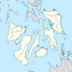
An earthquake off the coast of Samar occurred on August 31, 2012, at 20:47 local time (12:47 UTC) in the Philippines. The populated islands of Visayas were struck by an earthquake of magnitude Mw 7.6.[3] The earthquake occurred at a depth of 45 km (27.9 miles). A tsunami warning was announced within the Pacific area and was lifted after two hours. The Philippine archipelago is located in the Pacific Ring of Fire, where earthquakes and volcanic activity are common.
| UTC time | 2012-08-31 12:47:33 |
|---|---|
| ISC event | 601667544 |
| USGS-ANSS | ComCat |
| Local date | August 31, 2012 |
| Local time | 20:47 PST[1] |
| Magnitude | Mw 7.6[1] |
| Depth | 45 km (28 mi)[1] |
| Epicenter | 10°50′N 126°43′E / 10.83°N 126.71°E[1] |
| Type | Reverse[2] |
| Areas affected | Philippines |
| Max. intensity | PEIS VII (Destructive)[3] MMI VII (Very strong) |
| Tsunami | Yes (highest 20 inches) [4] |
| Aftershocks | 298 (as of September 2, 2012) |
| Casualties | 1 dead, 1 injured (as of September 1, 2012)[5] |

Geology edit
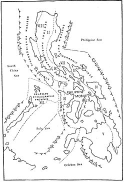
The Philippine Mobile Belt is between the Eurasia Plate and the Philippine Sea Plate. The Philippine Sea Plate is subducting along the Philippine Trench in this region. At the latitude of the earthquake, the Philippine Sea Plate moves in the WNW direction at a velocity of approximately 100 mm/yr with respect to the Sunda Plate.
This event was an intraplate earthquake greater than 50 kilometers to the east of the boundary of the Philippine Sea Plate. This earthquake was unusual in that it occurred as a result of reverse faulting within the oceanic lithosphere of the Philippine Sea Plate. There have been approximately 40 events of M6 and above over the past 40 years, within 250 km of this earthquake. Most of those earthquakes were the result of normal faulting within the shallower oceanic lithosphere rather than deeper reverse faulting like this event.[6]
Earthquake edit
After the initial earthquake, power supply was cut off in the affected areas after power lines were damaged. Power plants in Visayas tripped or shut down following the earthquake, although no major damage was sustained in transmission facilities.[7]
A house in the southern city of Cagayan de Oro, Mindanao, was involved in a landslide along with several other homes, killing one of its inhabitants and hospitalizing another.[8]
In General MacArthur, Eastern Samar, 77 homes were damaged. An additional six houses were damaged in Barangay Casoroy, San Julian.[9] A wall from an old building collapsed in Butuan.[10]
The National Disaster Risk Reduction and Management Council (NDRRMC) reported on Saturday noon that cracks had occurred in some structures such as bridges and roads.[11] The damage was not severe.[12]
Intensity edit
| Intensity
Scales |
Location |
|---|---|
| VII | Guiuan, Oras, Sulat, Borongan, Eastern Samar; Tacloban City |
| VI | Siargao, Surigao del Norte; Saint Bernard, S. Leyte |
| V | Mati City; Compostela; Legaspi City; Iloilo City; Bislig, Iligan City; Davao City; Cateel Davao Oriental ; Roxas City, Capiz |
| IV | Butuan, Catbalogan, Cagayan de Oro; Dipolog; Manukan, ZN; Polanco, ZN; Tagum, Davao del N., Digos; Dumaguete; Bacolod |
| III | Cotabato City, Mambajao, Camiguin, General Santos; Dao, Capiz, Dingle, Iloilo; Kidapawan City; Jaro, Iloilo; Daet, Cam. Norte; |
| II | Marawi City, Sipalay City, Hinigaran, La Carlota La Granja, Neg. Occ., Cebu City |
Tsunami edit
PHIVOLCS gave a level three tsunami alert in the Philippines and other institutes[which?] gave a level three tsunami alert in Japan, Indonesia, Taiwan, Palau indicating that the public should be on the watch for "unusual waves", but did not call for any evacuation. The Pacific Tsunami Warning Center rapidly issued tsunami warnings in the Pacific together with its adjacent islands. However, it was lifted after two hours as no tsunami was recorded. In Japan, the Japan Meteorological Agency issued tsunami warnings throughout the coastal areas of the country. The Hong Kong Observatory also issued a tsunami warning on Hong Kong at that same time.[citation needed]
About an hour after the quake, sea level readings from gauges in the epicentral region confirmed a tsunami was generated.[13] A small 3 cm (1.2 in) wave was recorded at Legazpi in Albay province shortly thereafter, as well as further south near Davao City; slight sea level anomalies were observed in several other locations.[14]
Response edit
Based on preliminary estimates of the magnitude, specialists noted that a significant tsunami could have been generated. A tsunami warning was issued within eight minutes after the tremor for coastal regions of the Philippines, Indonesia, Taiwan, Guam, and Japan, as well as for the island nations of Palau, Yap, and Northern Mariana. A tsunami watch was at the time in effect for much of Micronesia, the Solomon Islands, Hawaii, and the Pacific coast of Russia.[15][16] Most of the warnings and watches were quickly cancelled following revisions of the earthquake's magnitude, although the warnings for the Philippines, Indonesia and Palau remained in effect.[17]
The tremor caused widespread panic in Eastern Visayas, where many inhabitants exited their homes.[18] At the risk of destructive waves, officials in the Philippines urged remaining residents of eastern coastal areas to evacuate to higher ground.[17]
See also edit
References edit
- ^ a b c d "Earthquake Bulletin No. 5: 7.6 Samar Earthquake". Philippine Institute of Volcanology and Seismology. August 31, 2012. Retrieved August 31, 2017.
- ^ "M 7.6 - 89 km E of Sulangan, Philippines". earthquake.usgs.gov. U.S. Geological Survey. Retrieved 9 March 2022.
- ^ a b c "2012_0831_0540". Retrieved 28 December 2016.
- ^ "Most Popular E-mail Newsletter". USA Today. 2012-09-01. Archived from the original on 2012-09-04. Retrieved 2017-08-23.
- ^ Santos, Matikas. "7.6 quake jolts PH; 1 dead, child hurt". Philippine Daily Inquirer. Retrieved 28 December 2016.
- ^ "M 7.6 - Philippine Islands region". Retrieved 28 December 2016.
- ^ Fujita, Akiko (2012-08-31). "Quake off the Philippines triggers Tsunami Alert". ABC News. Retrieved 2012-08-31.
- ^ "At least 1 dead in 7.6 Philippines quake, small tsunami reported, warning canceled". Fox Newsdate=2012-08-31. Associated Press. 2012-08-31. Retrieved 2012-08-31.
- ^ "Quake damages 77 homes in E. Samar town". ABS-CBN News. Retrieved 28 December 2016.
- ^ "Quake causes panic, damage in Visayas, Mindanao". ABS-CBN News. Retrieved 28 December 2016.
- ^ "Strong quake, but minimal effects; gov't". The Philippine Star. Xinhua. 2 September 2012. Retrieved 2015-06-04.
- ^ "Philippine families rebuild amid further quake fears". Business Recorder=2012-09-02. Agence France-Presse. Retrieved 2012-09-02.
- ^ Tsunami Bulletin Number 003: 1425Z 31 Aug 2012 (Report). Pacific Tsunami Warning Center. 2012-08-31. Retrieved 2012-08-31.
- ^ Tsunami Bulletin Number 004: 1454Z 31 Aug 2012 (Report). Pacific Tsunami Warning Center. 2012-08-31. Retrieved 2012-08-31.
- ^ Tsunami Bulletin Number 001: 1255Z 31 Aug 2012 (Report). Pacific Tsunami Warning Center. 2012-08-31. Archived from the original on September 2, 2012. Retrieved 2012-08-31.
- ^ Bulletin: Tsunami Message Number 1: 257 AM HST Fri Aug 31 2012 (Report). Pacific Tsunami Warning Center. 2012-08-31. Archived from the original on September 2, 2012. Retrieved 2012-08-31.
- ^ a b Agence France-Presse (2012-08-31). "7.6 quake off Philippines". Bangkok Post. Retrieved 2012-08-31.
- ^ Birsel, Robert (2012-08-31). Laurence, Jeremy (ed.). "7.6 earthquake: Tsunami alert for Philippines, Indonesia only". Christian Science Monitor. Retrieved 2012-08-31.
External links edit
- The International Seismological Centre has a bibliography and/or authoritative data for this event.