


Summary
On January 23, 2018, at 00:31 AKST, an earthquake occurred in the Gulf of Alaska near Kodiak Island. The earthquake, measured at 7.9 on the Mw scale, was approximately 280 kilometers (170 mi) southeast of Kodiak and happened at a depth of 25 kilometers (16 mi).[2]
 Anchorage | |
| UTC time | 2018-01-23 09:31:40 |
|---|---|
| ISC event | 611653794 |
| USGS-ANSS | ComCat |
| Local date | January 23, 2018 |
| Local time | 00:31:42 Alaska Standard Time |
| Magnitude | 7.9 Mww[1] |
| Depth | 25 km (15.5 mi) |
| Epicenter | 56°02′46″N 149°04′23″W / 56.046°N 149.073°W |
| Type | Strike-slip |
| Areas affected | United States Canada |
| Max. intensity | MMI V (Moderate)[2] |
| Tsunami | Yes |
| Aftershocks | 564 (As of 1 March 2018)[3] |
| Casualties | None |
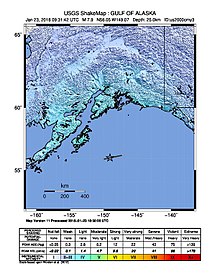
It was initially measured as a M 8.2 event, but later downgraded by the United States Geological Survey.[4] The earthquake was felt throughout most of southern Alaska, including the major cities of Anchorage and Fairbanks, and parts of neighboring British Columbia.[5][6]
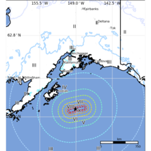
The earthquake prompted tsunami warnings and advisories for Alaska, British Columbia, Washington, Oregon, California, and Hawaii. Residents in low-lying areas along the Gulf of Alaska and in British Columbia were evacuated to shelters and higher ground. The Pacific Tsunami Warning Center later cancelled most of the alerts within four hours of the earthquake, due to the apparent lack of tsunami.[4][7] The highest recorded waves after the event measured at under 8.3 inches (21 cm) above tide level on Kodiak Island.[8]
Earthquake edit
According to the United States Geological Survey, the earthquake occurred 175 miles (282 km) southeast of Kodiak, Alaska at 12:31 AM local time (AKST).[2] Witnesses to the earthquake itself reported that it was very long in duration, feeling like a "slow roller," but it was not a violent earthquake despite its magnitude and mercalli intensity, as its epicentre was hundreds of kilometres offshore. This was corroborated by witnesses in Anchorage.[9][7] There was no immediate damage reported.[7] The earthquake woke people in Anchorage, 350 miles (560 km) from the epicenter, and was felt as far as Fairbanks to the northeast and British Columbia to the southeast.[5][6] The earthquake's S-waves arrived in Anchorage within one minute, and reached Fairbanks within three minutes.[10]
Tectonic setting edit
The earthquake was a strike-slip event that occurred within the Pacific Plate. The epicenter was to the south of the Aleutian Trench, where the Pacific Plate subducts beneath the North American Plate. The region has produced twelve large earthquakes since 1900, including several megathrust earthquakes.[2][11]
Aftershocks edit
The first major aftershocks occurred 20 minutes after the earthquake. The strongest aftershock measured 5.5 on the moment magnitude scale, while most measured 4–5.[7][12] Within two days, the United States Geological Survey recorded over 50 aftershocks.[13] More than 560 aftershocks have been recorded well into March.
Alerts and evacuations edit
Communities on Kodiak Island and other coastal areas on the Gulf of Alaska and Cook Inlet were evacuated after warning sirens were activated. Hundreds gathered in local schools, which were opened as evacuation shelters, in Kodiak,[14] Seward,[6] and Homer.[15] Evacuees seeking higher ground filled local roads and the parking lots of supermarkets,[7] while locals reported large numbers of evacuees parking near a wind farm on Pillar Mountain near Kodiak.[5] An unrelated power outage at the Alaska Earthquake Center in Fairbanks caused some alerts to be delayed, while its website was overwhelmed by the number of users.[6] The National Weather Service sent emergency alerts to cell phones in Alaska, reading, "Emergency Alert. Tsunami danger on the coast. Go to high ground or move inland."[16]
The National Weather Service and Pacific Tsunami Warning Center initially issued a tsunami watch for Hawaii and the entire West Coast, but cancelled them after less than two hours.[17] In the San Francisco Bay Area, residents within three blocks of the Pacific coast and five blocks of the San Francisco Bay were warned by the city's Department of Emergency Management to be ready for evacuation.[9]
Some aspects of the warning systems in place were delayed or failed to issue a warning at all, prompting multiple reviews of the warning infrastructure.[18]
See also edit
References edit
- ^ ANSS: Alaska 2018 (accessed March 24, 2018).
- ^ a b c d ANSS. "M 7.9 – 280km SE of Kodiak, Alaska". Comprehensive Catalog. U.S. Geological Survey. Retrieved January 23, 2018.
- ^ "USGS earthquake catalog". United States Geological Survey.
- ^ a b "Tsunami warning issued after magnitude 7.9 earthquake strikes off Alaska coast". Los Angeles Times. Associated Press. January 23, 2018. Retrieved January 23, 2018.
- ^ a b c Hanlon, Tegan; Hollander, Zaz; Herz, Nathaniel (January 23, 2018). "7.9 quake in Gulf of Alaska spurs tsunami alerts, evacuations". Anchorage Daily News. Retrieved January 23, 2018.
- ^ a b c d Hollander, Zaz; Hanlon, Tegan (January 23, 2018). "Orderly evacuations prevailed in Alaska coastal cities after 7.9 earthquake set off tsunami scare". Anchorage Daily News. Retrieved January 23, 2018.
- ^ a b c d e Mullany, Gerry; Ramzy, Austin; Fountain, Henry (January 23, 2018). "Alaska Earthquake Prompts Tsunami Warning". The New York Times. Retrieved January 23, 2018.
- ^ National Geophysical Data Center / World Data Service: NCEI/WDS Global Historical Tsunami Database. NOAA National Centers for Environmental Information. "Tsunami Event Information". doi:10.7289/V5PN93H7. Retrieved March 22, 2024.
- ^ a b Park, Madison; Allen, Keith (January 23, 2018). "Tsunami warning in effect after magnitude-7.9 earthquake off Alaska". CNN. CNN. Retrieved January 23, 2018.
- ^ "Magnitude 7.9 Offshore Kodiak". Alaska Earthquake Center. Archived from the original on January 28, 2018. Retrieved January 27, 2018.
- ^ "Tsunami warnings, watches from Alaska to Mexican border following Alaska earthquake". CBS News. January 23, 2018. Retrieved January 23, 2018.
- ^ "M 5.5 – 245km SE of Kodiak, Alaska". United States Geological Survey. January 23, 2018. Retrieved January 23, 2018.
- ^ Stinson, Nicole (January 25, 2018). "Alaska struck by another earthquake after huge quake sparks tsunami warning for US coast". Sunday Express. Retrieved January 27, 2018.
- ^ Borden, Mitch (January 23, 2018). "Kodiak residents wake up to tsunami sirens after earthquake". KMXT. Retrieved February 24, 2018.
- ^ Gross, Renee (January 23, 2018). "Residents seek shelter from possible tsunami". KBBI. Retrieved January 27, 2018.
- ^ "Tsunami warning cancelled". KINY. January 23, 2018. Retrieved January 23, 2018.
- ^ "Tsunami watch canceled for Hawaii after major Alaska quake". Honolulu Star-Advertiser. January 23, 2018. Retrieved January 23, 2018.
- ^ Bolton, Aaron (January 26, 2018). "Officials troubleshoot hiccups in EAS after tsunami warning". KBBI. Retrieved January 27, 2018.
External links edit
- The International Seismological Centre has a bibliography and/or authoritative data for this event.