


Summary
The 45th Street station is a local station on the BMT Fourth Avenue Line of the New York City Subway. Located at 45th Street and Fourth Avenue in Sunset Park, Brooklyn, it is served by the R train at all times. The N train also stops here during late nights, and some rush-hour W trains stop here in the peak direction.
45 Street | ||||||||||||||||||||||||||||||||||||||||||||||||||||||||||||||||||||
|---|---|---|---|---|---|---|---|---|---|---|---|---|---|---|---|---|---|---|---|---|---|---|---|---|---|---|---|---|---|---|---|---|---|---|---|---|---|---|---|---|---|---|---|---|---|---|---|---|---|---|---|---|---|---|---|---|---|---|---|---|---|---|---|---|---|---|---|---|
 Manhattan bound platform | ||||||||||||||||||||||||||||||||||||||||||||||||||||||||||||||||||||
| Station statistics | ||||||||||||||||||||||||||||||||||||||||||||||||||||||||||||||||||||
| Address | 45th Street & Fourth Avenue Brooklyn, NY 11220[1] | |||||||||||||||||||||||||||||||||||||||||||||||||||||||||||||||||||
| Borough | Brooklyn | |||||||||||||||||||||||||||||||||||||||||||||||||||||||||||||||||||
| Locale | Sunset Park | |||||||||||||||||||||||||||||||||||||||||||||||||||||||||||||||||||
| Coordinates | 40°38′58″N 74°00′34″W / 40.64944°N 74.00944°W | |||||||||||||||||||||||||||||||||||||||||||||||||||||||||||||||||||
| Division | B (BMT)[2] | |||||||||||||||||||||||||||||||||||||||||||||||||||||||||||||||||||
| Line | BMT Fourth Avenue Line | |||||||||||||||||||||||||||||||||||||||||||||||||||||||||||||||||||
| Services | N R W | |||||||||||||||||||||||||||||||||||||||||||||||||||||||||||||||||||
| Transit | ||||||||||||||||||||||||||||||||||||||||||||||||||||||||||||||||||||
| Structure | Underground | |||||||||||||||||||||||||||||||||||||||||||||||||||||||||||||||||||
| Platforms | 2 side platforms | |||||||||||||||||||||||||||||||||||||||||||||||||||||||||||||||||||
| Tracks | 4 | |||||||||||||||||||||||||||||||||||||||||||||||||||||||||||||||||||
| Other information | ||||||||||||||||||||||||||||||||||||||||||||||||||||||||||||||||||||
| Opened | September 22, 1915[4] | |||||||||||||||||||||||||||||||||||||||||||||||||||||||||||||||||||
| Opposite- direction transfer | Yes | |||||||||||||||||||||||||||||||||||||||||||||||||||||||||||||||||||
| Traffic | ||||||||||||||||||||||||||||||||||||||||||||||||||||||||||||||||||||
| 2022 | 1,610,445[5] | |||||||||||||||||||||||||||||||||||||||||||||||||||||||||||||||||||
| Rank | 179 out of 423[5] | |||||||||||||||||||||||||||||||||||||||||||||||||||||||||||||||||||
| ||||||||||||||||||||||||||||||||||||||||||||||||||||||||||||||||||||
| ||||||||||||||||||||||||||||||||||||||||||||||||||||||||||||||||||||
| ||||||||||||||||||||||||||||||||||||||||||||||||||||||||||||||||||||
| ||||||||||||||||||||||||||||||||||||||||||||||||||||||||||||||||||||
| ||||||||||||||||||||||||||||||||||||||||||||||||||||||||||||||||||||


The 45th Street station was constructed as part of the Fourth Avenue Line, which was approved in 1905. Construction on the segment of the line that includes 45th Street started on March 15, 1913, and was completed in 1915. The station opened on September 22, 1915, after the opening of the initial portion of the BMT Fourth Avenue Line to 59th Street.[4] The station's platforms were lengthened in 1926–1927,[6] and again during a renovation in 1968–1970.[7]
History edit
Construction and opening edit
The 45th Street station was constructed as part of the Fourth Avenue Line, the plan for which was initially adopted on June 1, 1905.[8] The Rapid Transit Commission was succeeded on July 1, 1907, by the New York State Public Service Commission (PSC), which approved the plan for the line in late 1907.[9][10]
As part of negotiations between New York City, the Brooklyn Rapid Transit Company (BRT), and the Interborough Rapid Transit Company for the expansion of the city's transit network, the line was leased to a subsidiary of the BRT. The agreement, known as Contract 4 of the Dual Contracts, was signed on March 19, 1913.[9] In 1912, during the Dual System negotiations, the construction of an extension of the Fourth Avenue subway from 43rd Street to 89th Street, just south of the 86th Street station, was recommended. The proposal was approved by the Board of Estimate on February 15, 1912. The PSC directed its chief engineer to create plans on June 14, 1912. The two contracts for the extension, Route 11B, were awarded on September 16, 1912, to Degnon Construction Company for a combined $3.8 million (equivalent to $120 million in 2023).[9]
Construction on Route 11B1, the section of the extension between 43rd Street and 61st Street, which includes the 45th Street station, began on March 15, 1913. Originally, this section was planned to have two tracks, but after the connection to the Sea Beach Line was added to the plan during the middle of construction, the plan was changed to four tracks. This section was completed in 1915.[8] The section of the line running through the 45th Street station opened on June 22, 1915, as part of an extension of the subway to Coney Island, which included the Fourth Avenue Line north of 59th Street as well as the entire Sea Beach Line.[11][12] The line's opening was marked with a competition between two trains heading from Chambers Street station in Manhattan to the Coney Island station, one heading via the West End Line and the other via the Sea Beach Line; the latter got to Coney Island first.[12] However, the 45th and 53rd Street stations remained closed,[13] despite being technically complete, since the stations were being used by a contractor to haul dirt out.[14] The stations opened on September 22, 1915.[4]
Station renovations edit
1920s edit
On June 27, 1922, the New York State Transit Commission commissioned its engineers to examine platform-lengthening plans for 23 stations on the lines of the Brooklyn–Manhattan Transit Corporation (BMT), the successor to the BRT, to accommodate eight-car trains. As part of the project, 45th Street's platforms would have been lengthened from 490 feet (150 m) to 530 feet (160 m).[15][16] Though the Transit Commission ordered the BMT to lengthen these platforms in September 1923, no further progress was made until February 16, 1925, when the New York City Board of Transportation (NYCBOT) commissioned its engineers to examine platform-lengthening plans for this and eleven other stations along the Fourth Avenue Line. It estimated the project would cost $633,000 (equivalent to $10,998,000 in 2023).[17] The NYCBOT received bids for the project on February 25, 1926.[18] The contract was awarded to the Corson Construction Company for $345,021 (equivalent to $5,938,000 in 2023).[19] The extensions opened on August 1, 1927.[6]
1960s edit
The city government took over the BMT's operations on June 1, 1940.[20][21] In the 1960s, the New York City Transit Authority (NYCTA) started a project to lengthen station platforms on its lines in Southern Brooklyn to 615 feet (187 m) to accommodate 10-car trains.[7] On July 14, 1967, the NYCTA awarded a contract to conduct test borings at eleven stations on the Fourth Avenue Line, including 45th Street, to the W. M. Walsh Corporation for $6,585 (equivalent to $60,172 in 2023) in preparation of the construction of platform extensions.[22] The NYCTA issued an invitation for bids on the project to extend the platforms at stations along the Fourth Avenue Line between this station and Bay Ridge–95th Street on May 3, 1968.[23]
As part of the renovation project, the station's platforms were extended 85 feet (26 m).[7] The northbound was extended to the north, and the southbound platform was extended to the south.[24] In addition, the station's elaborate mosaic tile walls were covered over with 8-by-16-inch (20 by 41 cm) white cinderblock tiles. The latter change, which was also made to 15 other stations on the BMT Broadway and Fourth Avenue Line, was criticized for being dehumanizing. The NYCTA spokesman stated that the old tiles were in poor condition and that the change was made to improve the appearance of stations and provide uniformity. Furthermore, it did not consider the old mosaics to have "any great artistic merit".[25]
Station layout edit
| Ground | Street level | Exit/entrance |
| Mezzanine | Fare control, station agent | |
| Platform level | Side platform | |
| Northbound local | ← ← ← | |
| Northbound express | ← | |
| Southbound express | | |
| Southbound local | | |
| Side platform | ||
This underground station has four tracks and two side platforms. The R stops here at all times;[26] some rush-hour W trains stop here in the peak direction;[27] and the N stops here during late nights, but uses the center express tracks to bypass the station during daytime hours.[28] The station is between 36th Street to the north and 53rd Street to the south.[29] The platforms are offset as the northbound platform extends further north than the southbound one.[30]
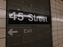
Columns run along the entire length of both platforms at regular intervals and are painted dark grey-blue. Every other column has the standard black name plate with white text. All are round except for the ones near the staircases to the station's main entrance, which are I-beams; this is where the platforms were extended in 1970.[31][32]
Prior to the station's 1970 renovation, it was finished all in white and marble tile, and it had its own color scheme to allow regular passengers to identify the station based only on the color of the marble trimmings.[9] Since the renovation, the station walls have consisted of white cinderblock tiles, except for small recesses in the walls, which contain gray-painted cinderblock tiles. The gray cinderblock field contains the station-name signs and white text pointing to the exits.[33]

Exits edit
The station's main entrance is a mezzanine above the platforms and tracks at the north end. It has two staircases to the Manhattan-bound platform[34] and one to the Bay Ridge-bound one at the extreme south end,[35] a waiting area that allows a free transfer between directions, turnstile bank, token booth, and two staircases to the northern corners of 45th Street and 4th Avenue.[36] The mezzanine contains some of the original mosaic directional and arrow signs. The one by the staircases to the southbound platform says "Down Town trains" while the one by the Manhattan-bound platform staircases says "Up Town Trains."[37][38]
The southbound platform formerly had an exit-only at the center that led to 46th Street. Evidence of this includes a gated door on the platform wall and adjacent "EXIT" signs.[39][40] The northwest corner exit was closed after it was accidentally destroyed by nearby construction workers. On May 16, 1979, Community Board 7 held a meeting to determine whether residents wanted the entrance closed.[41] The board's chairman cited crime as a reason to close the entrance. The New York City Transit Authority promised to comply with the wish of the board, and the entrance was closed.[42]
References edit
- ^ "Borough of Brooklyn, New York City". Government of New York City. Archived from the original on September 14, 2020. Retrieved April 16, 2020.
- ^ "Glossary". Second Avenue Subway Supplemental Draft Environmental Impact Statement (SDEIS) (PDF). Vol. 1. Metropolitan Transportation Authority. March 4, 2003. pp. 1–2. Archived from the original (PDF) on February 26, 2021. Retrieved January 1, 2021.
- ^ "Brooklyn Bus Map" (PDF). Metropolitan Transportation Authority. October 2020. Retrieved December 1, 2020.
- ^ a b c "Stations of Subway are Now Opened". Home Talk the Item. September 22, 1915. pp. 1, 14 – via newspapers.com
 .
.
- ^ "Annual Subway Ridership (2017–2022)". Metropolitan Transportation Authority. 2022. Retrieved November 8, 2023.
- ^ a b "B.M.T. Stations Ready For Eight-Car Trains". Brooklyn Standard Union. August 1, 1927. p. 1. Retrieved April 9, 2020 – via newspapers.com .
- ^ a b c New York City Transit Authority Annual Report For The Year June 30, 1960. New York City Transit Authority. 1960. pp. 16–17.
- ^ a b Rogoff, David (May 1961). "The Fourth Ave. Subway". New York Division Bulletin. Electric Railroaders' Association: 2–10. Retrieved May 8, 2017.
- ^ a b c d Fourth Avenue Subway, Brooklyn's New Transportation Line: A Part of the Dual System of Rapid Transit of the City of New York. New York City: Public Service Commission. June 19, 1915. p. 18. hdl:2027/uiug.30112067596715 – via HathiTrust.
- ^ "Fourth Avenue Subway Is Sent To A Committee". The Brooklyn Daily Eagle. March 20, 1908. pp. 1–2. Retrieved May 4, 2017 – via newspapers.com .
- ^ Cudahy, Brian J. (2009). How We Got to Coney Island: The Development of Mass Transportation in Brooklyn and Kings County. Fordham University Press. pp. 217–218. ISBN 978-0-8232-2211-7. Retrieved April 24, 2020.
- ^ a b "Through Tube to Coney, 48 Minutes: First Train on Fourth Avenue Route Beats West End Line Eleven Minutes". The Brooklyn Daily Eagle. June 22, 1915. Retrieved June 29, 2015 – via newspapers.com .
- ^ "Celebration of Opening Fourth Ave. Subway". Home Talk the Item. June 23, 1915. p. 1. Retrieved April 9, 2020 – via newspapers.com .
- ^ "Stations Ready, But Are Not Available". Home Talk the Item. July 21, 1915. pp. 1, 2 – via newspapers.com .
- ^ Legislature, New York (State) (1923). Second Annual Report of the Transit Commission (For the Calendar Year 1922). New York State Transit Commission. p. 100.
- ^ Proceedings of the Transit Commission, State of New York Volume III From January 1 to December 31, 1923. New York State Transit Commission. 1923. p. 1277.
- ^ "12 B-M. T. Stations To Be Lengthened". The New York Times. February 17, 1925. ISSN 0362-4331. Retrieved May 4, 2017.
- ^ "Board Receives Platform Bids For B.M.T. Lines. Six Companies Submit Prices for Extending Subway Stations". The Brooklyn Citizen. February 26, 1926. p. 5. Retrieved April 7, 2020 – via newspapers.com .
- ^ "Brooklyn Wins Big Improvement Fund". Brooklyn Standard Union. March 18, 1926. p. 20. Retrieved April 7, 2020 – via newspapers.com .
- ^ "B.M.T. Lines Pass to City Ownership; $175,000,000 Deal Completed at City Hall Ceremony-- Mayor 'Motorman No. 1'". The New York Times. June 2, 1940. ISSN 0362-4331. Archived from the original on July 19, 2021. Retrieved May 14, 2022.
- ^ "City Takes Over B. M. T. System; Mayor Skippers Midnight Train". New York Herald Tribune. June 2, 1940. p. 1. ProQuest 1243059209.
- ^ Minutes and Proceedings. New York City Transit Authority. 1967. pp. 379–380.
- ^ Engineering News-record. McGraw-Hill. 1968. p. 75.
- ^ Rogoff, Dave (February 1969). "BMT Broadway Subway Platform Extensions" (PDF). New York Division Bulletin. 12 (1). Electric Railroaders' Association: 4. Archived from the original (PDF) on September 15, 2020. Retrieved May 22, 2020.
- ^ Burks, Edward C. (February 21, 1970). "Subways' Colored Tile Gets Cover‐Up Job". The New York Times. ISSN 0362-4331. Retrieved April 7, 2020.
- ^ "R Subway Timetable, Effective August 28, 2023". Metropolitan Transportation Authority. Retrieved August 26, 2023.
- ^ "W Subway Timetable, Effective June 26, 2022". Metropolitan Transportation Authority. Retrieved August 26, 2023.
- ^ "N Subway Timetable, Effective August 28, 2023". Metropolitan Transportation Authority. Retrieved August 26, 2023.
- ^ "Subway Map" (PDF). Metropolitan Transportation Authority. September 2021. Retrieved September 17, 2021.
- ^ Dougherty, Peter (2006) [2002]. Tracks of the New York City Subway 2006 (3rd ed.). Dougherty. OCLC 49777633 – via Google Books.
- ^ Cox, Jeremiah (June 5, 2009). "A view down the Bay Ridge-bound side platform at 45 Street". subwaynut.com. Retrieved December 18, 2018.
- ^ Cox, Jeremiah (October 1, 2012). "Looking down the Bay Ridge-bound platform at 45 Street, this portion must be part of the area added when the platform was extended since it has I-beams all along it". subwaynut.com. Retrieved December 18, 2018.
- ^ Cox, Jeremiah (June 5, 2009). "A 45 Street platform sign, text and an arrow for the only exit to 45 St painted beneath it". subwaynut.com. Retrieved December 18, 2018.
- ^ Cox, Jeremiah (October 1, 2012). "Looking across to the offset Manhattan-bound platform and the two staircases it has to the mezzanine". subwaynut.com. Retrieved December 18, 2018.
- ^ Cox, Jeremiah (June 5, 2009). "Approaching the single staircase up to street level from the Bay Ridge-bound platform at 45 Street". subwaynut.com. Retrieved December 18, 2018.
- ^ "MTA Neighborhood Maps: Sunset Park" (PDF). mta.info. Metropolitan Transportation Authority. 2015. Retrieved August 2, 2015.
- ^ Cox, Jeremiah (June 5, 2009). "A mosaic sign for Up Town trains above a modern To 95 Street R sign at 45 Street". subwaynut.com. Retrieved December 18, 2018.
- ^ Cox, Jeremiah (June 5, 2009). "A Down Town Trains mosaic above a modern Manhattan & Queens R sign on the mezzanine at 45 Street". subwaynut.com. Retrieved December 18, 2018.
- ^ Cox, Jeremiah (June 5, 2009). "A close up of partially painted over text for the now closed exit to 46 St". subwaynut.com. Retrieved December 18, 2018.
- ^ Cox, Jeremiah (June 5, 2009). "A gated door where a high exit turnstile to 46 Street used to leave the Bay Ridge-bound platform from". subwaynut.com. Retrieved December 18, 2018.
- ^ "Public Hearing". New York Daily News. May 14, 1979. Retrieved December 18, 2018 – via newspapers.com .
- ^ "Express Ideas on BMT Station". New York Daily News. May 14, 1979. Retrieved December 18, 2018 – via newspapers.com .
External links edit
- nycsubway.org – BMT 4th Avenue: 45th Street
- Station Reporter — R Train
- The Subway Nut — 45th Street Pictures Archived August 5, 2020, at the Wayback Machine
- 45th Street entrance from Google Maps Street View
- Platforms from Google Maps Street View