
KNOWPIA
WELCOME TO KNOWPIA

A4135 road 
Summary
The A4135 road is a road in Gloucestershire, England, connecting the town of Tetbury with the M5 motorway and the A38 road to the west, passing through Beverston, Dursley and Cam en route to Slimbridge.
 | ||||
|---|---|---|---|---|
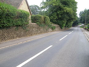 Looking east along the A4135 road in the village of Beverston | ||||
| Route information | ||||
| Length | 12.9 mi[1] (20.8 km) | |||
| Major junctions | ||||
| southeast end | Tetbury 51°38′20″N 2°09′44″W / 51.6390°N 2.1621°W | |||
| northwest end | Slimbridge 51°43′24″N 2°22′18″W / 51.7234°N 2.3717°W | |||
| Location | ||||
| Country | United Kingdom | |||
| Road network | ||||
| ||||
2001 Dursley speed camera edit
In 2001 a speed camera was installed at Dursley with an associated speed limit zone of 30 miles per hour (48 km/h).[2] The image (right) depicts a typical stretch of the A4135 road; the dry-stone wall illustrated is of considerable age.
See also edit
 Roads portal
- Slimbridge Wildfowl Trust
References edit
External links edit
- Recent Schedule of Works for Gloucestershire Roads
51°39′59″N 2°16′56″W / 51.6664°N 2.2823°W