
KNOWPIA
WELCOME TO KNOWPIA

Abajo Peak 
Summary
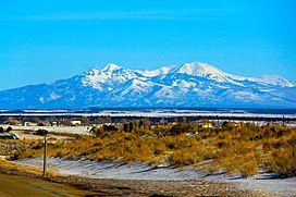
Abajo Peak is the highest peak in the Abajo Mountains of southeast Utah, United States and is located in the Manti-La Sal National Forest. The summit is 7 miles (11 km) southwest of Monticello, Utah and 23 miles (37 km) west of the Colorado border. There are several communication towers on the peak.[3]
| Abajo Peak | |
|---|---|
 | |
| Highest point | |
| Elevation | 11,368 ft (3,465 m) NAVD 88[1] |
| Prominence | 4,550 ft (1,387 m)[2] |
| Coordinates | 37°50′22″N 109°27′45″W / 37.83953149°N 109.46243775°W[1] |
| Geography | |
 Abajo Peak | |
| Parent range | Abajo Mountains |
| Topo map | USGS Abajo Peak Quad |
| Climbing | |
| Easiest route | Hike |
References edit
- ^ a b "Abajo Peak 2". NGS Data Sheet. National Geodetic Survey, National Oceanic and Atmospheric Administration, United States Department of Commerce.
- ^ "Abajo Peak, Utah". Peakbagger.com.
- ^ "Abajo Peak". SummitPost.org.
External links edit
![]() Media related to Abajo Peak at Wikimedia Commons
Media related to Abajo Peak at Wikimedia Commons
- "Abajo Peak". Geographic Names Information System. United States Geological Survey, United States Department of the Interior.