


Summary
Adalaj is a census town in Gandhinagar district located in the western Indian state of Gujarat.[1] With a population of roughly 12,000 residents within the town limits as of 2011, Adalaj is known for its semi-arid climate and its historic and religious establishments. The town sits in a generally flat area covering about 18 sq. km.
Adalaj | |
|---|---|
Town | |
Clockwise: Adalaj stepwell, a market, and Trimandir temple. | |
 | |
 Adalaj Location in Gujarat, India  Adalaj Adalaj (Gujarat)  Adalaj Adalaj (India) | |
| Coordinates: 23°10′N 72°35′E / 23.17°N 72.58°E | |
| Country | |
| State | Gujarat |
| District | Gandhinagar |
| Taluka | Gandhinagar |
| Government | |
| • Type | Panchayat |
| • Gram Panchayat | Kokilaben R Thakor |
| Area | |
| • Town | 17.91 km2 (6.92 sq mi) |
| • Land | 17.91 km2 (6.92 sq mi) |
| • Urban | 17.91 km2 (6.92 sq mi) |
| Elevation | 66 m (217 ft) |
| Highest elevation | 69 m (226 ft) |
| Lowest elevation | 63 m (207 ft) |
| Population (2011) | |
| • Town | 11,957 |
| • Rank | 1,262 |
| • Density | 670/km2 (1,700/sq mi) |
| Languages | |
| • Official | Gujarati, Hindi |
| Time zone | UTC+5:30 (IST) |
| PIN | 382 421 |
| STD code | +91-2712 |
| Vehicle registration | GJ |
| Website | Gandhinagar District Panchayat |
| [1][2] | |

The city has seen recent rapid urbanization since the last census report.
Geography edit
Adalaj is located at 23°10′N 72°35′E / 23.17°N 72.58°E.[3] It has an average elevation of 66 metres (217 ft).[citation needed] According to the Bureau of Indian Standards, the town falls under seismic zone 3, in a scale of 2 to 5 (in order of increasing vulnerability to earthquakes).[4]
Climate edit
Adalaj has substantially similar climate to Ahmedabad which is a hot, semi-arid climate (Köppen climate classification: BSh), with marginally less rain than required for a tropical savanna climate. The Indian Meteorological Department does not distinguish Adalaj through a distinct weather station, therefore seasonal and monsoon conditions mimic recorded values of Ahmedabad.
There are three main seasons: summer, monsoon and winter. Aside from the monsoon season, the climate is extremely dry. The weather is hot from March to June. Cold northerly winds are responsible for a mild chill in January. The southwest monsoon brings a humid climate from mid-June to mid-September. The average annual rainfall is about 595 millimetres (23.4 in), and it is not uncommon for droughts to occur when the monsoon does not extend as far west as usual.
| Climate data for Adalaj (1981–2010) | |||||||||||||
|---|---|---|---|---|---|---|---|---|---|---|---|---|---|
| Month | Jan | Feb | Mar | Apr | May | Jun | Jul | Aug | Sep | Oct | Nov | Dec | Year |
| Mean daily maximum °C (°F) | 28.2 (82.8) |
31.9 (89.4) |
36.7 (98.1) |
40.9 (105.6) |
42.5 (108.5) |
39.2 (102.6) |
33.3 (91.9) |
31.6 (88.9) |
33.0 (91.4) |
35.3 (95.5) |
32.5 (90.5) |
29.1 (84.4) |
34.5 (94.1) |
| Daily mean °C (°F) | 20.2 (68.4) |
22.5 (72.5) |
27.6 (81.7) |
31.7 (89.1) |
34.3 (93.7) |
33.1 (91.6) |
29.7 (85.5) |
28.5 (83.3) |
29.2 (84.6) |
28.5 (83.3) |
24.8 (76.6) |
21.4 (70.5) |
27.6 (81.7) |
| Mean daily minimum °C (°F) | 14.7 (58.5) |
17.5 (63.5) |
21.8 (71.2) |
25.9 (78.6) |
28.5 (83.3) |
29.8 (85.6) |
27.6 (81.7) |
25.9 (78.6) |
25.3 (77.5) |
24.2 (75.6) |
20.8 (69.4) |
16.5 (61.7) |
23.2 (73.8) |
| Average rainfall mm (inches) | 1.0 (0.04) |
1.0 (0.04) |
2.0 (0.08) |
1.0 (0.04) |
1.0 (0.04) |
57.0 (2.24) |
187.0 (7.36) |
232.0 (9.13) |
92.0 (3.62) |
10.0 (0.39) |
11.0 (0.43) |
0.0 (0.0) |
595 (23.41) |
| Average rainy days | 0.6 | 0.4 | 1.1 | 1.1 | 0.8 | 12.5 | 23.2 | 21.9 | 13.2 | 2.5 | 1.7 | 0.4 | 79.4 |
| Average relative humidity (%) | 37 | 29 | 24 | 25 | 33 | 49 | 70 | 77 | 70 | 42 | 37 | 34 | 44 |
| Mean monthly sunshine hours | 287.3 | 274.3 | 277.5 | 297.2 | 329.6 | 238.3 | 130.1 | 111.4 | 220.6 | 290.7 | 274.1 | 288.6 | 3,019.7 |
| Average ultraviolet index | 6 | 7 | 8 | 9 | 9 | 8 | 7 | 7 | 7 | 7 | 6 | 5 | 7 |
| Source 1: India Meteorological Department [5] | |||||||||||||
| Source 2: NOAA (sun and humidity 1971–1990),[6] Weather Atlas[7] | |||||||||||||
Demographics edit
| Year | Pop. | ±% |
|---|---|---|
| 1971 | 4,221 | — |
| 1981 | 7,291 | +72.7% |
| 1991 | 10,484 | +43.8% |
| 2001 | 9,774 | −6.8% |
| 2011 | 11,957 | +22.3% |
| Source: [citation needed] | ||
As of 2011[update] India census,[8] Adalaj had a population of 11,957.
Religion edit
According to the 2011 census, Hindus are the predominant religious community in the city comprising 94.86% of the population followed by Muslims (2.22%) and Jains (2.08%). Christians, Sikhs, and those who didn't state any religion make up the remainder.[9]
Languages edit
As of 2011, 88% of residents had Gujarati as a first language, while 10% had Hindi. The remaining 2% were split among several other Indic languages.
Literacy and Gender edit
Males constitute 51% of the population and females 49%. Adalaj has an average literacy rate of 61%, higher than the national average of 59.5%; with 59% of the males and 41% of females literate. 15% of the population is under 6 years of age.[citation needed]
Civic administration edit
Adalaj is a census town, promoted in 2001 from village status, administered through the namesake gram panchayat, which itself is a combination of local areas, through the elected sarpanch and other members. This area is a part of the Gandhinagar taluka, one of four blocks, in the Gandhinagar district of Gujarat.
Central and state representation edit
Adalaj is part of Gandhinagar South Assembly constituency for representation in the Vidhan Sabha and one of the state legislative assembly constituencies that form the Ahmedabad East Lok Sabha constituency for representation in the Lok Sabha.
Economy edit
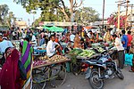
As of 2001, the local economy's main manufactured and exported commodities were bricks, paddy, and pearl millet.[1] Additionally, wheat, cotton, tobacco, castor, mustard seed, and consumed vegetables are grown in the generally agrarian based economy.
Infrastructure edit
Public transport edit
Bus edit
Adalaj is served by several bus networks. Ahmedabad Municipal Transport Service, or AMTS, runs three lines into the town, all of which terminate at or around the Adalaj Trimandir. These routes provide connections to long distance rail through Western Railways, the proposed bullet train service, and proposed Metro service at Kalupur Station; passenger air travel at Sardar Vallabhbhai Patel International Airport; and upscale full-service starred lodging near Iskcon Cross Road. Gujarat State Road Transport Corporation, or GSRTC, provides intercity and regional bus service through bus stops located at the northern corner of the cloverleaf interchange. Additionally, Ahmedabad BRTS is providing service to Trimandir.
Road edit
The town is primarily serviced by the east-west running Sarkhej–Gandhinagar Highway which forms a major part of NH 147 and the north-south running Gujarat State Highway 41, commonly referred to as Ahmedabad-Kalol Highway. The resulting cloverleaf interchange geographically located in town's center splits the neighborhoods.
These 8 and 10 lane surface highways have various uncontrolled crosswalks at high traffic areas, points of interest, and bus stations. Several smaller roads and alleys form the remaining paved transportation infrastructure.
Air edit
Informal helipads have been constructed by private parties, but no formal airfield exists within the ward boundaries. The closest commercial airport with regularly scheduled passenger flights is Sardar Vallabhbhai Patel International Airport, which is 15 to 20 kilometers driving distance south of the town in Ahmedabad.
Arts and culture edit
Tourist attractions edit
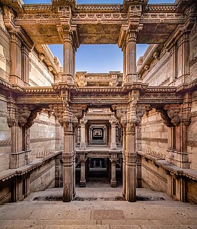
Adalaj Stepwell edit
The Adalaj Stepwell[1][10] is situated 18 kilometres (11 mi) away from Gandhinagar in the heart of what historically has been known as Adalaj. Built in 1499 A.D. by Queen Rudabai, the stepwell, or vav, is intricately carved and five stories deep. The carvings on its walls and pillars include leaves, flowers, birds, fish, geometrical patterns, and other breathtaking ornamental designs. In the past, these step wells were frequented by travelers and caravans as stopovers along trade routes.
On entering through one of the three gates, visitors are greeted by a mandap with an eight-sided dome, which is now damaged. On both sides of the steps are balconies. Rows of carved elephants mark some of the levels.[11]
Adalaj Trimandir edit
The Adalaj Trimandir[10][12][13] is an expansive nonsectarian temple inspired by Dada Bhagwan opened 29 December 2002. The Trimandir is a two-storey structure with a discourse hall on the ground floor and temple on the first floor. The entire structure, with a centre shikhar height of 33 meters, is set with intricate carvings on pink sandstone.
The main hall of the temple measures 10,000 square feet (930 m2). The centre sanctum houses a 3.9-meter idol of Simandhar Swami along with the idols of his Chandrayan Yaksh dev and Panchanguli Yakshini devi. Additionally, it houses idols of other Tirthankara and dev/devis. The left sanctum hosts Shivling, Parvati, Hanuman and Ganapati, whereas the right sanctum comprises Krishna, Tirupati Balaji Shreenathji, Bhadrakali mata and Amba mata. The two extreme ends of the temple houses Padmaprabhu and Sai Baba.
See also edit
References edit
- ^ a b c d Parimal, Jayant (2006). Census of India 2001, District Census Handbook, Part XII A & B, Gandhinagar District, Village & Town Directory (PDF) (Report). New Delhi: Government of India. pp. xxiv, 5, 32, 60, 67–68. Archived (PDF) from the original on 14 June 2022. Retrieved 13 June 2022.
- ^ "ગાંધીનગર સરપંચ લિસ્ટ (Sarpanch List)". ગાંધીનગર તાલુકા પંચાયત (in Gujarati). Government of Gujarat. 16 June 2020. Retrieved 9 January 2023.
- ^ "Maps, Weather, and Airports for Adalaj, India". Falling Rain. Falling Rain Software, Ltd. Retrieved 24 June 2006.
- ^ "Performance of buildings during the 2001 Bhuj earthquake" (PDF). Jag Mohan Humar, David Lau, and Jean-Robert Pierre. The Canadian Association for Earthquake Engineering. Archived from the original (PDF) on 10 July 2007. Retrieved 3 August 2008.
- ^ "Ahmedabad Climatological Table Period: 1981–2010". India Meteorological Department. Archived from the original on 2 April 2015. Retrieved 25 March 2015.
- ^ "Ahmedabad Climate Normals 1971–1990". National Oceanic and Atmospheric Administration. Retrieved 25 March 2015.
- ^ "Monthly weather forecast and climate of Adalaj". Weather Atlas. Retrieved 13 June 2022.
- ^ "Census of India 2001: Data from the 2001 Census, including cities, villages and towns (Provisional)". Census Commission of India. Archived from the original on 16 June 2004. Retrieved 1 November 2008.
- ^ "Population by religion community – 2011". Census of India, 2011. The Registrar General & Census Commissioner, India.
- ^ a b "Places of Interest - District Gandhingar,Govt. of Gujarat - India". Gandhinagar District. District Administrator, Gandhinagar District, Govt. of Gujarat. Archived from the original on 18 April 2021. Retrieved 14 June 2022.
- ^ "Adlaj Vav - An Architectural Marvel". Maps of India. Compare Infobase Pvt. Ltd. Archived from the original on 20 May 2011. Retrieved 14 June 2022.
- ^ "New Gujarat CM is Devotee of Guru Dada Bhagwan. Here's What the 'Purification Movement' Means". News18. Network18 Media and Investments Ltd. 13 September 2021. Archived from the original on 14 September 2021. Retrieved 14 June 2022.
- ^ Bhatia, Monisha (18 September 2014). "PM Modi Being blessed by Dada Bhagwan Foundation Head Pujya Deepak Bhai Desai at Trimandir Adalaj Gujrat". Delhi News Agency. India: Dhumraketu Media Private Limited. Archived from the original on 16 March 2017. Retrieved 14 June 2022.
External links edit
 Media related to Adalaj at Wikimedia Commons