


Summary
Adams Glacier is situated on the northwest flank of Mount Adams, a 12,281-foot (3,743 m) stratovolcano in the U.S. state of Washington.[3] Much of it becomes the source of Adams Creek, a tributary of the Cispus River. It is the largest glacier on Mount Adams. It flows down from the summit ice cap at over 12,000 feet (3,700 m) for over 2.5 miles (4.0 km) to a terminus near 7,000 feet (2,100 m).
| Adams Glacier | |
|---|---|
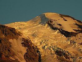 Adams Glacier from the northwest | |
 Adams Glacier  Adams Glacier | |
| Type | Mountain glacier |
| Location | Mount Adams, Yakima / Skamania counties, Washington, United States |
| Coordinates | 46°13′2″N 121°30′42″W / 46.21722°N 121.51167°W[1] |
| Area | 3.68 km2 (1.42 sq mi) in 2006[2] |
| Length | 2.5 miles (4.0 km) |
| Terminus | Moraines |
| Status | Retreating |

Between 11,800 and 9,200 feet (3,600 and 2,800 m), the glacier flows through a steep icefall that provides challenging climbing through a maze of seracs. The first ascent of the glacier was by Fred Beckey, Dave Lind, and Robert Mulhall in July 1945.[4]
Below 8,400 feet (2,600 m), the glacier spreads into a broad sheet with five separate tongues of ice extending out to termini between large moraines. On its easternmost tongue, it ends at a glacial tarn, or small ice-choked lake above High Camp.
In 1904, the area was approximately 6.93 km2 and in 2021 the area was 2.2 km2 representing an area loss of 68%.[2] [5]
In 1901, when Mount Adams was being mapped and its glaciers named by Harry Fielding Reid, Reid's companion and guide, Claude Ewing Rusk, wanted to name the glacier Reid Glacier in honor of Reid; however, Reid insisted that it should be named something else because he thought it improper to place his own name on the map that he was making and the Mazamas were trying to name a glacier on Mount Hood after him. This eventually persuaded Rusk and he conceded to name the glacier Adams Glacier.[6]
See also edit
References edit
- ^ "Adams Glacier". Geographic Names Information System. United States Geological Survey, United States Department of the Interior. Retrieved 3 November 2012.
- ^ a b Sitts, Danielle; Andrew G. Fountain; Matthew J. Hoffman (2010). "Twentieth Century Glacier Change on Mount Adams, Washington, USA" (pdf). Northwest Science. 84 (4). Northwest Scientific Association: 378–385. doi:10.3955/046.084.0407. Retrieved 2012-11-03.
- ^ Mount Adams West, WA (Map). TopoQwest (United States Geological Survey Maps). Retrieved 3 November 2012.
- ^ Beckey, Fred (2000). Cascade Alpine Guide: Climbing and High Routes: Volume 1, Columbia River to Stevens Pass (3rd ed.). Mountaineers Books. p. 352. ISBN 0-89886-577-8.
- ^ Pelto, Mauri (2021-09-07). "Adams Glacier, Washington 50% area loss since 1998, No retained Snow in 2021". From a Glacier's Perspective. Retrieved 2022-03-05.
- ^ Rusk, Claude Ewing (1978) [1924]. Tales of a Western Mountaineer (1st ed.). Seattle, Washington: The Mountaineers. ISBN 0-916890-62-7. LCCN 78054427. OCLC 4667368. OL 11004497M. Retrieved March 29, 2016.