


Summary
Adast is a village and commune in the Hautes-Pyrénées department in southwestern France. It is in Sent Savin valley in the Bigorre region.
Adast | |
|---|---|
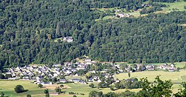 View of the village | |
 Coat of arms | |
Location of Adast .mw-parser-output .locmap .od{position:absolute}.mw-parser-output .locmap .id{position:absolute;line-height:0}.mw-parser-output .locmap .l0{font-size:0;position:absolute}.mw-parser-output .locmap .pv{line-height:110%;position:absolute;text-align:center}.mw-parser-output .locmap .pl{line-height:110%;position:absolute;top:-0.75em;text-align:right}.mw-parser-output .locmap .pr{line-height:110%;position:absolute;top:-0.75em;text-align:left}.mw-parser-output .locmap .pv>div{display:inline;padding:1px}.mw-parser-output .locmap .pl>div{display:inline;padding:1px;float:right}.mw-parser-output .locmap .pr>div{display:inline;padding:1px;float:left}html.skin-theme-clientpref-night .mw-parser-output .od,html.skin-theme-clientpref-night .mw-parser-output .od .pv>div,html.skin-theme-clientpref-night .mw-parser-output .od .pl>div,html.skin-theme-clientpref-night .mw-parser-output .od .pr>div{background:#000;color:#fff}html.skin-theme-clientpref-night .mw-parser-output .locmap{filter:grayscale(0.6)}@media(prefers-color-scheme:dark){html.skin-theme-clientpref-os .mw-parser-output .locmap{filter:grayscale(0.6)}html.skin-theme-clientpref-os .mw-parser-output .od,html.skin-theme-clientpref-os .mw-parser-output .od .pv>div,html.skin-theme-clientpref-os .mw-parser-output .od .pl>div,html.skin-theme-clientpref-os .mw-parser-output .od .pr>div{background:#000;color:#fff}}  Adast  Adast | |
| Coordinates: 42°58′29″N 0°04′36″W / 42.9747°N 0.0767°W | |
| Country | France |
| Region | Occitania |
| Department | Hautes-Pyrénées |
| Arrondissement | Argelès-Gazost |
| Canton | La Vallée des Gaves |
| Intercommunality | Pyrénées Vallées des Gaves |
| Government | |
| • Mayor (2020–2026) | Serge Laguibeau[1] |
| Area 1 | 1.05 km2 (0.41 sq mi) |
| Population (2021)[2] | 300 |
| • Density | 290/km2 (740/sq mi) |
| Time zone | UTC+01:00 (CET) |
| • Summer (DST) | UTC+02:00 (CEST) |
| INSEE/Postal code | 65001 /65260 |
| Elevation | 434–542 m (1,424–1,778 ft) (avg. 444 m or 1,457 ft) |
| 1 French Land Register data, which excludes lakes, ponds, glaciers > 1 km2 (0.386 sq mi or 247 acres) and river estuaries. | |
Geography edit
The commune is bordered by four other communes. It also borders Lau-Balagnas by a simple quadripoint: Saint-Savin to the west, Lau-Balagnas by a quadripoint to the north, Beaucens to the east, and finally by Pierrefitte-Nestalas to the south.
Population edit
| Year | Pop. | ±% p.a. |
|---|---|---|
| 1968 | 174 | — |
| 1975 | 200 | +2.01% |
| 1982 | 205 | +0.35% |
| 1990 | 203 | −0.12% |
| 1999 | 227 | +1.25% |
| 2007 | 244 | +0.91% |
| 2012 | 273 | +2.27% |
| 2017 | 292 | +1.35% |
| Source: INSEE[3] | ||
Sites and monuments edit
In 1270, the Château de Miramont was bequeathed after the death of Mathe de Bigorre-Mâtas to one of his daughters, Marguerite.
In the 17th century, it became the refuge of the poet Cyprian Despourrins whose mother was Gabrielle de Miramont. The castle was then bought by Bernard Abadie-Gaye, an inhabitant of Sazos (near Luz-Saint-Sauveur). It was then sold by a descendant of this family, Célestin Carrere, son of Louise Abadie-Gaye, in 1914.
The château was later inhabited by Dr. Jean François Calot (1861-1944), a surgeon who advanced orthopaedic surgery preferring conservative treatments to the systematic amputations. He spent his entire career from 1890 at Berck and he retired to the Château de Miramont.
At the end of the 1960s, the Château de Miramont was bought by the journalist, radio and television host Jacques Chancel, who came from the nearby village of Ayzac-Ost.
See also edit
References edit
- ^ "Répertoire national des élus: les maires". data.gouv.fr, Plateforme ouverte des données publiques françaises (in French). 9 August 2021.
- ^ "Populations légales 2021". The National Institute of Statistics and Economic Studies. 28 December 2023.
- ^ Population en historique depuis 1968, INSEE