
KNOWPIA
WELCOME TO KNOWPIA

Aime-la-Plagne 
Summary
Aime-la-Plagne (French pronunciation: [ɛm la plaɲ]) is a commune in the Savoie department of southeastern France. The municipality was established on 1 January 2016 and consists of the former communes of Aime, Granier and Montgirod.[3]
Aime-la-Plagne | |
|---|---|
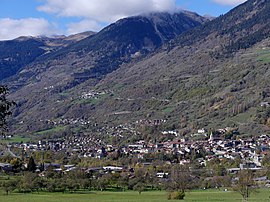 A general view of Aime-la-Plagne | |
 Coat of arms | |
Location of Aime-la-Plagne .mw-parser-output .locmap .od{position:absolute}.mw-parser-output .locmap .id{position:absolute;line-height:0}.mw-parser-output .locmap .l0{font-size:0;position:absolute}.mw-parser-output .locmap .pv{line-height:110%;position:absolute;text-align:center}.mw-parser-output .locmap .pl{line-height:110%;position:absolute;top:-0.75em;text-align:right}.mw-parser-output .locmap .pr{line-height:110%;position:absolute;top:-0.75em;text-align:left}.mw-parser-output .locmap .pv>div{display:inline;padding:1px}.mw-parser-output .locmap .pl>div{display:inline;padding:1px;float:right}.mw-parser-output .locmap .pr>div{display:inline;padding:1px;float:left}html.skin-theme-clientpref-night .mw-parser-output .od,html.skin-theme-clientpref-night .mw-parser-output .od .pv>div,html.skin-theme-clientpref-night .mw-parser-output .od .pl>div,html.skin-theme-clientpref-night .mw-parser-output .od .pr>div{background:#000;color:#fff}html.skin-theme-clientpref-night .mw-parser-output .locmap{filter:grayscale(0.6)}@media(prefers-color-scheme:dark){html.skin-theme-clientpref-os .mw-parser-output .locmap{filter:grayscale(0.6)}html.skin-theme-clientpref-os .mw-parser-output .od,html.skin-theme-clientpref-os .mw-parser-output .od .pv>div,html.skin-theme-clientpref-os .mw-parser-output .od .pl>div,html.skin-theme-clientpref-os .mw-parser-output .od .pr>div{background:#000;color:#fff}}  Aime-la-Plagne  Aime-la-Plagne | |
| Coordinates: 45°33′25″N 6°39′07″E / 45.557°N 6.652°E | |
| Country | France |
| Region | Auvergne-Rhône-Alpes |
| Department | Savoie |
| Arrondissement | Albertville |
| Canton | Bourg-Saint-Maurice |
| Intercommunality | Les Versants d'Aime |
| Government | |
| • Mayor (2020–2026) | Corine Maironi-Gonthier[1] |
| Area 1 | 94.67 km2 (36.55 sq mi) |
| Population (2021)[2] | 4,421 |
| • Density | 47/km2 (120/sq mi) |
| Time zone | UTC+01:00 (CET) |
| • Summer (DST) | UTC+02:00 (CEST) |
| INSEE/Postal code | 73006 /73210 |
| 1 French Land Register data, which excludes lakes, ponds, glaciers > 1 km2 (0.386 sq mi or 247 acres) and river estuaries. | |
Population edit
| Year | Pop. | ±% p.a. |
|---|---|---|
| 1968 | 3,183 | — |
| 1975 | 3,222 | +0.17% |
| 1982 | 3,358 | +0.59% |
| 1990 | 3,679 | +1.15% |
| 1999 | 3,916 | +0.70% |
| 2007 | 4,168 | +0.78% |
| 2012 | 4,382 | +1.01% |
| 2017 | 4,443 | +0.28% |
| Source: INSEE[4] | ||
See also edit
References edit
Wikimedia Commons has media related to Aime-la-Plagne.
- ^ "Répertoire national des élus: les maires" (in French). data.gouv.fr, Plateforme ouverte des données publiques françaises. 13 September 2022.
- ^ "Populations légales 2021". The National Institute of Statistics and Economic Studies. 28 December 2023.
- ^ Arrêté préfectoral 17 November 2015 (in French)
- ^ Population en historique depuis 1968, INSEE