


Summary
Aira (姶良市, Aira-shi) is a city located in Kagoshima Prefecture, Japan. It is located west of Kirishima and north of Kagoshima.
Aira
姶良市 | |
|---|---|
 Aira City Hall | |
 Flag  Seal | |
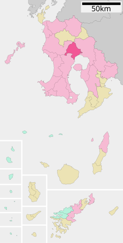 Location of Aira in Kagoshima Prefecture | |
 Aira Location in Japan | |
| Coordinates: 31°43′42″N 130°37′40″E / 31.72833°N 130.62778°E | |
| Country | |
| Region | Kyūshū |
| Prefecture | |
| Government | |
| • Mayor | Yoshihiro Yumoto |
| Area | |
| • Total | 231.32 km2 (89.31 sq mi) |
| Population (October 1, 2020) | |
| • Total | 76,405 |
| • Density | 330.3/km2 (855/sq mi) |
| Time zone | UTC+09:00 (JST) |
| Postal code | 899-5492 |
| Phone number | 0995-66-3111 |
| Address | 25 Miyajimamachi, Aira-shi, Kagoshima-ken |
| Climate | Cfa |
| Website | Official website |
| Symbols | |
| Flower | Cerasus jamasakura Rhododendron |
| Tree | Cinnamomum camphora |
The modern city of Aira was established on March 23, 2010, from the merger of the former town of Aira, absorbing the towns of Kajiki and Kamō (all from Aira District).
As of October 1, 2020, the city has a population of 76,405 and a population density of 330.3 persons per km2. The total area is 231.32 km2.
It is accessed with the Kyushu Expressway at interchange 25, the Kajiki Interchange and interchange 26, the Aira Interchange. The expressway passed through Aira, connecting Kagoshima to the west and Kirishima to the North. The interchange was first opened on December 13, 1973. There are five railway stations in the city. From east to west, Kajiki, Kinkō, Chōsa, Aira and Shigetomi stations serve the city. All of these stations belong to Nippō Main Line, and are operated by Kyushu Railway Company (JR Kyushu).
Aira's claim to fame is a stone gate in the village of Yamada which commemorates the victory of the Russo-Japanese War.
The plan for the merger of the three towns was defeated twice. Once in 2005 and again in 2008. These defeats were due to a debt in public finance and the number of seats in the city council. Finally, in 2009, town representatives compromised with these problems and the merger plan was accepted. Aira District will be left with one municipality.[1]
Geography edit
Surrounding municipalities edit

Demography edit
According to Japanese census data,[3] this is the population of Aira in recent years.
| Year | Pop. | ±% |
|---|---|---|
| 1920 | 45,008 | — |
| 1925 | 46,192 | +2.6% |
| 1930 | 48,069 | +4.1% |
| 1935 | 48,198 | +0.3% |
| 1940 | 46,749 | −3.0% |
| 1945 | 65,023 | +39.1% |
| 1950 | 65,252 | +0.4% |
| 1955 | 62,892 | −3.6% |
| 1960 | 57,292 | −8.9% |
| 1965 | 52,891 | −7.7% |
| 1970 | 51,608 | −2.4% |
| 1975 | 55,540 | +7.6% |
| 1980 | 62,992 | +13.4% |
| 1985 | 66,830 | +6.1% |
| 1990 | 68,789 | +2.9% |
| 1995 | 71,762 | +4.3% |
| 2000 | 73,640 | +2.6% |
| 2005 | 74,840 | +1.6% |
| 2010 | 74,817 | −0.0% |
| 2015 | 75,173 | +0.5% |
| 2020 | 76,348 | +1.6% |
| Aira population statistics[3] | ||
Climate edit
Aira has a humid subtropical climate (Köppen climate classification Cfa). The average annual temperature is about 17 °C (63 °F), and the annual rainfall is about 2,200 mm (87 in). Most of the rainfall is concentrated from June to September.[4] Typhoons often strike from summer to autumn. In addition, Sakurajima is located about 20 km south of the city, and volcanic ash may fall when a northerly wind blows during volcanic activity. As with other cities, towns and villages in the mainland of Kagoshima Prefecture, the forecast of wind direction over Sakurajima, which is reported in the weather forecast, is of great concern.
| Climate data for Aira, Kagoshima | |||||||||||||
|---|---|---|---|---|---|---|---|---|---|---|---|---|---|
| Month | Jan | Feb | Mar | Apr | May | Jun | Jul | Aug | Sep | Oct | Nov | Dec | Year |
| Daily mean °C (°F) | 5.7 (42.3) |
8.1 (46.6) |
9.0 (48.2) |
14.0 (57.2) |
19.4 (66.9) |
24.4 (75.9) |
29.0 (84.2) |
29.1 (84.4) |
25.7 (78.3) |
21.2 (70.2) |
13.7 (56.7) |
8.3 (46.9) |
17.3 (63.2) |
| Average precipitation mm (inches) | 115.0 (4.53) |
183.5 (7.22) |
145.5 (5.73) |
263.5 (10.37) |
209.0 (8.23) |
427.0 (16.81) |
460.0 (18.11) |
222.5 (8.76) |
133.5 (5.26) |
— | 107.5 (4.23) |
58.5 (2.30) |
— |
| Source: 気象観測[5] | |||||||||||||
Notable people edit
- Munenori Kawasaki - professional baseball player
- Kota Ibushi - Japanese professional wrestler
- Shoji Jo - professional football player
See also edit
References edit
- ^ "市町村合併情報 鹿児島県 <国土地理協会>". Archived from the original on 2008-04-18. Retrieved 2008-09-13.
- ^ Sakurajima Volcano, Kyushu, Japan - January 28, 2013
- ^ a b Aira population statistics
- ^ 新市まちづくり計画(原案) (PDF) (in Japanese). 姶良西部合併協議会. Retrieved April 21, 2022.
- ^ 鹿児島県森林技術総合センター(蒲生町上久徳)で2008年に観測した気象データ (in Japanese). Japan Meteorological Agency. Retrieved April 21, 2022.
External links edit
- Aira City official website (in Japanese)