
KNOWPIA
WELCOME TO KNOWPIA

Airaines 
Summary
Airaines (French pronunciation: [ɛʁɛn]; Picard: Araine) is a commune in the Somme department in Hauts-de-France in northern France.
Airaines | |
|---|---|
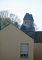
 A rooftop view of Airaines, with the church of St-Denis | |
 Coat of arms | |
Location of Airaines .mw-parser-output .locmap .od{position:absolute}.mw-parser-output .locmap .id{position:absolute;line-height:0}.mw-parser-output .locmap .l0{font-size:0;position:absolute}.mw-parser-output .locmap .pv{line-height:110%;position:absolute;text-align:center}.mw-parser-output .locmap .pl{line-height:110%;position:absolute;top:-0.75em;text-align:right}.mw-parser-output .locmap .pr{line-height:110%;position:absolute;top:-0.75em;text-align:left}.mw-parser-output .locmap .pv>div{display:inline;padding:1px}.mw-parser-output .locmap .pl>div{display:inline;padding:1px;float:right}.mw-parser-output .locmap .pr>div{display:inline;padding:1px;float:left}html.skin-theme-clientpref-night .mw-parser-output .od,html.skin-theme-clientpref-night .mw-parser-output .od .pv>div,html.skin-theme-clientpref-night .mw-parser-output .od .pl>div,html.skin-theme-clientpref-night .mw-parser-output .od .pr>div{background:#000;color:#fff}html.skin-theme-clientpref-night .mw-parser-output .locmap{filter:grayscale(0.6)}@media(prefers-color-scheme:dark){html.skin-theme-clientpref-os .mw-parser-output .locmap{filter:grayscale(0.6)}html.skin-theme-clientpref-os .mw-parser-output .od,html.skin-theme-clientpref-os .mw-parser-output .od .pv>div,html.skin-theme-clientpref-os .mw-parser-output .od .pl>div,html.skin-theme-clientpref-os .mw-parser-output .od .pr>div{background:#000;color:#fff}}  Airaines  Airaines | |
| Coordinates: 49°57′57″N 1°56′39″E / 49.9658°N 1.9442°E | |
| Country | France |
| Region | Hauts-de-France |
| Department | Somme |
| Arrondissement | Amiens |
| Canton | Ailly-sur-Somme |
| Intercommunality | Somme Sud-Ouest |
| Government | |
| • Mayor (2020–2026) | Albert Noblesse[1] |
| Area 1 | 24.88 km2 (9.61 sq mi) |
| Population (2021)[2] | 2,279 |
| • Density | 92/km2 (240/sq mi) |
| Time zone | UTC+01:00 (CET) |
| • Summer (DST) | UTC+02:00 (CEST) |
| INSEE/Postal code | 80013 /80270 |
| Elevation | 15–116 m (49–381 ft) (avg. 49 m or 161 ft) |
| 1 French Land Register data, which excludes lakes, ponds, glaciers > 1 km2 (0.386 sq mi or 247 acres) and river estuaries. | |
Geography edit
The commune is situated 30 km (19 mi) north west of Amiens, about 30 km (19 mi) south of Abbeville, at the junction of the D901 and D936 roads.
Hamlets and neighbourhoods edit

- Dourier : Originally a hamlet to the northeast of the town, now a suburb.
- Dreuil-Hamel : Stretching out to the west, sprinkled with orchards and meadows, this commune was once separate. By decree of 26 September 1972 it was joined with Airaines in a simple merger.
Population edit
| Year | Pop. | ±% p.a. |
|---|---|---|
| 1968 | 2,239 | — |
| 1975 | 2,303 | +0.40% |
| 1982 | 2,385 | +0.50% |
| 1990 | 2,175 | −1.15% |
| 1999 | 2,099 | −0.39% |
| 2007 | 2,153 | +0.32% |
| 2012 | 2,363 | +1.88% |
| 2017 | 2,378 | +0.13% |
| Source: INSEE[3] | ||
History edit
- In earlier times, the town flourished, due mainly to the importance of the castle of the dukes of Luynes.
- During World War II, the town was subject to much destruction in June 1940. The Market hall was destroyed.
- The years 1985-2000 saw the closure of several important economical activities, resulting in high unemployment
-
 The towers before 1914
 -
 Luynes towers in 2007
 -
 Notre-Dame church before 1914
 -
 Market hall before 1914


Places and monuments edit
- Saint-Denis church
- The Priory (Notre Dame church)
- Dreuil-Hamel church, abandoned and in danger of collapsing
- The towers of the dukes of Luynes
- The memorial to Charles N'Tchoréré
- A monument aux morts with sculptural work by Albert Dominique Roze
-
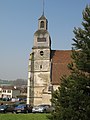 St-Denis church tower
 -
 Luynes towers
 -
 The Priory


People edit
Charles N'Tchoréré (15 November 1896 - 1940) was a Gabonese military commander who was shot by the Germans in World War II during the battle for France.
Twin towns edit
See also edit
References edit
- ^ "Répertoire national des élus: les maires". data.gouv.fr, Plateforme ouverte des données publiques françaises (in French). 2 December 2020.
- ^ "Populations légales 2021". The National Institute of Statistics and Economic Studies. 28 December 2023.
- ^ Population en historique depuis 1968, INSEE
External links edit
Wikimedia Commons has media related to Airaines.
(All French language)
- The Priory website
- Official municipal website