


Summary
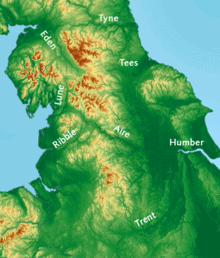
53°52′55″N 1°54′17″W / 53.8819°N 1.9048°W Airedale is a valley, or dale, in North Yorkshire and West Yorkshire, England. It is named after the River Aire, which flows through it. The upper valley, from Malham Cove to Airton, is known as Malhamdale, named after the village of Malham.[1] At Airton the valley widens and becomes Airedale proper. The river flows past Skipton on to Keighley, Bingley, Shipley, and Leeds.

Airedale, in conjunction with the Ribble Valley, provides low-altitude passes from Yorkshire to Lancashire through the Aire Gap. It is therefore an important transport route and was a strategically important area historically.[2]
History edit
* Airedale to Ribblesdale 144 m (472 ft) near Barnoldswick. * Airedale to Pendle Water 165 m (541 ft) near Colne. * Airedale to Londsdale 166 m (545 ft) near Settle.[3]
The upper Aire valley was formed 12,000 years ago by a retreating glacier. A moraine formed in the Cononley area and the lake stretched as far north as Gargrave. Colonisation by man developed later on, especially during the Iron Age. The peoples that occupied the Aire Valley (and much of north eastern England) were called Brigantes by the Romans.[4]
Transport improved in the 18th and 19th centuries with the building of the Aire and Calder Navigation[5] and the Leeds and Liverpool Canal.[6] The railways arrived from the 1830s onwards and during the twentieth century the roads were vastly improved in the valley.
Airedale was formerly wholly within the West Riding of Yorkshire.[7]
Description edit


The upper valley is within the Yorkshire Dales and Yorkshire Dales National Park. From Aire Springs the river flows past Skipton and Keighley, through Bingley, Saltaire, Shipley and into Leeds. Up until this point the river is essentially swift flowing and fed by streams and becks.
The broad definition of Airedale includes all the areas adjacent to the River Aire and its tributaries. The Aire Catchment Flood Management Plan (CFMP), which takes into account all the becks and streams that feed the river, lists the Worth Valley and most of Bradford City as part of Airedale.[8] Similarly, the Airedale Partnership's Masterplan, which is sponsored by Bradford Council, shows the same boundaries as the Aire CFMP.[9]
Geology edit

The upper section between Malham and Skipton is largely upfaulted Carboniferous limestone. The middle section between Skipton and Knottingley is peat and gritstone, with steep valley walls crested with moorland prevalent between Skipton and Shipley.[10] The sandstone deposits between Skipton and Leeds have characterised the buildings within this part of Airedale, whilst the deposits of Limestone, Coal, Fireclay and Ironstone fuelled industrial developments.[11]
Tourism edit
Airedale is notable for several tourist sites and the World Heritage Site of Saltaire village.[12] Other attractions include The Keighley and Worth Valley Railway, Bingley Five Rise Locks, The Shipley Glen Tramway, East Riddlesden Hall, Rodley Nature Reserve, Kirkstall Abbey, The Royal Armouries (Leeds), St Aidan's Nature Reserve and Fairburn Ings Nature Reserve.
Industry edit
Many of the former woollen and cotton mills of the dale have been demolished or converted into housing. The heavy industry east of Leeds is still in existence and two of the three coal fired powers stations in the lower section take their water from the River Aire. Industry that lies alongside the Aire includes Ferrybridge,[13] Eggborough and Drax power stations, Eggborough Saint Gobain glassworks, Stolze and Allied Glass in Knottingley and Kellingley Colliery.
Leeds City Council have an enterprise zone that covers 400 acres of regenerated land along the Aire Valley from the city centre up to junction 45 of the M1 (known as Gateway 45). This houses several manufacturing and food companies.[14]
Eponyms edit
The names Aire and Airedale are associated with many things and areas. Most notable in the valley are Airedale General Hospital, Aireborough[15] (a region comprising mostly Wharfedale towns) and Airedale, a suburb of Castleford.
The area gives its name to the Airedale Terrier, the largest of the terrier group of dogs. They were first bred in the area in the nineteenth century.[16]
References edit
- ^ Yorkshire Dales National Park Authority. "Landscape Character Assessment interactive map". Yorkshire Dales National Park. Retrieved 15 October 2023.
- ^ "The Aire Gap". The Yorkshire Dales. Retrieved 26 November 2015.
- ^ Google Earth Archived 8 September 2010 at the Wayback Machine Altitudes given by Google Earth maps
- ^ Hodgson, Trevor; Gulliver, David (2000). "A history of Cononley; an Airedale village" (PDF). Lakeland dawn designs. Kiln Hill. Retrieved 26 November 2015.
- ^ "Aire and Calder Navigation". Canals and River Trust. Retrieved 26 November 2015.
- ^ "Leeds and Liverpool Canal". Canals and River Trust. Retrieved 26 November 2015.
- ^ "Yorkshire Map". Yorkshire Ridings Society. Retrieved 26 November 2015.
- ^ "Aire Catchment" (PDF). Gov. Environment Agency. December 2010. p. 5. Retrieved 26 November 2015.
- ^ "Airedale Corridors" (PDF). Airedale Partnership. AP. p. 10. Retrieved 26 November 2015.
- ^ "Skipton". Domesday Reloaded. BBC. 1986. Retrieved 26 November 2015.
- ^ "Airedale Corridors" (PDF). Airedale Partnership. AP. p. 11. Retrieved 26 November 2015.
- ^ "Salts Mill". Bradford and West Yorkshire. BBC. 4 March 2008. Retrieved 26 November 2015.
- ^ "Ferrybridge". SSE. SSE. Archived from the original on 4 July 2014. Retrieved 26 November 2015.
- ^ "Aire Valley Leeds". Leeds city region enterprise zone. LCC. 2014. Retrieved 26 November 2015.
- ^ "Aireborough Historical Society". Aireborough Historical Society. Retrieved 26 November 2015.
- ^ Rush, James (30 January 2009). "Bingley walk organised for famous breed". Telegraph and Argus. Retrieved 26 November 2015.