


Summary
Aizumisato (会津美里町, Aizumisato-machi) is a town located in Fukushima Prefecture, Japan. As of 1 March 2020[update], the town had an estimated population of 20,092 in 7306 households [1] and a population density of 73 persons per km2. The total area of the town was 276.33 square kilometres (106.69 sq mi).
Aizumisato
会津美里町 | |
|---|---|
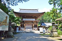 Isasumi Shrine | |
 Flag  Seal | |
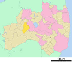 Location of Aizumisato in Fukushima Prefecture | |
 Aizumisato | |
| Coordinates: 37°27′35.5″N 139°50′28″E / 37.459861°N 139.84111°E | |
| Country | Japan |
| Region | Tōhoku |
| Prefecture | Fukushima |
| District | Ōnuma |
| Area | |
| • Total | 276.33 km2 (106.69 sq mi) |
| Population (March 2020) | |
| • Total | 20,092 |
| • Density | 73/km2 (190/sq mi) |
| Time zone | UTC+9 (Japan Standard Time) |
| – Tree | Styphnolobium japonicum |
| – Flower | Iris sanguinea |
| – Bird | Wagtail |
| Phone number | 0242-55-1122 |
| Address | 3163 Miyakita, Aizumisato-machi, Ōnuma-gun, Fukushima-ken 969-6292 |
| Website | Official website |


Geography edit
Aizumisato is located in the eastern portion of the Aizu region, in west-central Fukushima Prefecture on the southwestern edge of the Aizu Basin.
- Mountains: Mount Hakase, Mount Myojindake (1074 m)
- Rivers: Aka River
- Lakes: Miyagawa Dam
Neighboring municipalities edit
Fukushima Prefecture
Climate edit
Aizumisato has a Humid continental climate (Köppen Dfb) characterized by warm summers and cold winters with heavy snowfall. The average annual temperature in Aizumisato is 13.1 °C. The average annual rainfall is 1320 mm with September as the wettest month. The temperatures are highest on average in August, at around 24.8 °C, and lowest in January, at around −1.4 °C.[2]
Demographics edit
Per Japanese census data,[3] the population of Aizumisato has declined steadily over the past 40 years.
| Year | Pop. | ±% |
|---|---|---|
| 1950 | 38,522 | — |
| 1960 | 36,073 | −6.4% |
| 1970 | 30,036 | −16.7% |
| 1980 | 27,945 | −7.0% |
| 1990 | 27,211 | −2.6% |
| 2000 | 27,172 | −0.1% |
| 2010 | 22,727 | −16.4% |
History edit
The area of present-day Aizumisato was part of ancient Mutsu Province and formed part of the holdings of Aizu Domain during the Edo period. After the Meiji Restoration, it was organized as part of Ōnuma District in Fukushima Prefecture. The town of Aizumisato was created on October 1, 2005 with the merger of the two towns of Aizutakada and Aizuhongō and the village of Niitsuru, all from Ōnuma District.[4]
Economy edit
The economy of Aizumisato is dominated by agriculture.
Education edit
Aizumisato has five public elementary schools and three public junior high schools operated by the town government. The town has one public high school operated by the Fukushima Prefectural Board of Education.
- Fukushima Prefectural Aizumisato High School
Transportation edit
Railway edit
Highway edit
 Ban-etsu Expressway – Niitsuru PA
 National Route 401
Local attractions edit
- Mukaihaguroyama Castle ruins, a National Historic Site[5]
- Sakurdari Kannon
Sister-city relationships edit
Aizumisato has a sister-city relationship with the town of Naraha, also in Fukushima Prefecture. This is a renewal of the relationship Niitsuru had with Naraha prior to the merger.[6]
References edit
- ^ Aizumisato official town statistics(in Japanese)
- ^ Aizumisato climate data
- ^ Aizumisato population statistics
- ^ "合併後の住居表示について" Archived 2008-08-13 at the Wayback Machine. Retrieved on 22 December 2008. (in Japanese)
- ^ "向羽黒山城跡". Cultural Heritage Online (in Japanese). Agency for Cultural Affairs. Retrieved 23 October 2018.
- ^ 姉妹友好都市 – 会津美里町 Archived 2009-02-27 at the Wayback Machine (Shimai yūkō toshi – Aizumisato), town web site, retrieved on December 22, 2008
External links edit
![]() Media related to Aizumisato, Fukushima at Wikimedia Commons
Media related to Aizumisato, Fukushima at Wikimedia Commons
- Official Website(in Japanese)