


Summary
Aizy-Jouy (French pronunciation: [ɛzi ʒwi]) is a commune in the department of Aisne in the Hauts-de-France region of northern France.
Aizy-Jouy | |
|---|---|
Commune | |
 | |
Location of Aizy-Jouy .mw-parser-output .locmap .od{position:absolute}.mw-parser-output .locmap .id{position:absolute;line-height:0}.mw-parser-output .locmap .l0{font-size:0;position:absolute}.mw-parser-output .locmap .pv{line-height:110%;position:absolute;text-align:center}.mw-parser-output .locmap .pl{line-height:110%;position:absolute;top:-0.75em;text-align:right}.mw-parser-output .locmap .pr{line-height:110%;position:absolute;top:-0.75em;text-align:left}.mw-parser-output .locmap .pv>div{display:inline;padding:1px}.mw-parser-output .locmap .pl>div{display:inline;padding:1px;float:right}.mw-parser-output .locmap .pr>div{display:inline;padding:1px;float:left}html.skin-theme-clientpref-night .mw-parser-output .od,html.skin-theme-clientpref-night .mw-parser-output .od .pv>div,html.skin-theme-clientpref-night .mw-parser-output .od .pl>div,html.skin-theme-clientpref-night .mw-parser-output .od .pr>div{background:#000;color:#fff}html.skin-theme-clientpref-night .mw-parser-output .locmap{filter:grayscale(0.6)}@media(prefers-color-scheme:dark){html.skin-theme-clientpref-os .mw-parser-output .locmap{filter:grayscale(0.6)}html.skin-theme-clientpref-os .mw-parser-output .od,html.skin-theme-clientpref-os .mw-parser-output .od .pv>div,html.skin-theme-clientpref-os .mw-parser-output .od .pl>div,html.skin-theme-clientpref-os .mw-parser-output .od .pr>div{background:#000;color:#fff}}  Aizy-Jouy  Aizy-Jouy | |
| Coordinates: 49°26′07″N 3°31′02″E / 49.4353°N 3.5172°E | |
| Country | France |
| Region | Hauts-de-France |
| Department | Aisne |
| Arrondissement | Soissons |
| Canton | Fère-en-Tardenois |
| Intercommunality | Val de l'Aisne |
| Government | |
| • Mayor (2020–2026) | Amadéo Neca[1] |
| Area 1 | 14.63 km2 (5.65 sq mi) |
| Population (2021)[2] | 303 |
| • Density | 21/km2 (54/sq mi) |
| Time zone | UTC+01:00 (CET) |
| • Summer (DST) | UTC+02:00 (CEST) |
| INSEE/Postal code | 02008 /02370 |
| Elevation | 56–195 m (184–640 ft) (avg. 84 m or 276 ft) |
| 1 French Land Register data, which excludes lakes, ponds, glaciers > 1 km2 (0.386 sq mi or 247 acres) and river estuaries. | |
Geography edit
Aizy-Jouy is some 15 km north-east of Soissons and 20 km south-east of Laon. National Highway N2 from Soissons to Laon passes just north of the commune. The commune can be accessed by Highway D14 running south from the N2 continuing through the heart of the commune and the town continuing south to Vailly-sur-Aisne. Highway D15 branches from the D14 at the southern border of the commune and heads north-east through the eastern part of the commune and then to Pargny-Filain. There are also several small country roads criss-crossing the commune and exiting on all sides of the commune. There are no villages or hamlets in the commune other than Aizy-Jouy.[3]
A stream rises from ponds north of the town and flows south through the commune joining with other streams rising in the north-east of the commune and flowing south to the river Aisne. The commune has a substantial amount of forest mostly following the course of the streams with the rest of commune (about 30%) farmland.[3]
Neighbouring communes and towns edit
History edit
In 1972, the two towns of Aizy and Jouy merged to form Aizy-Jouy after the edict of the préfecture dated 24 January 1972.
Administration edit
This list is incomplete; you can help by adding missing items. (April 2021) |
List of Mayors of Aizy-Jouy[4]
| From | To | Name | Party |
|---|---|---|---|
| 2001 | 2008 | Éric De Wulf | DVD |
| 2008 | 2014 | Yannick Lecluze | |
| 2014 | 2020 | Éric De Wulf | DVD |
| 2020 | Present | Amadéo Neca[1] |
Population edit
Before 1971 the communes of Aizy and Jouy were separate and their population was counted separately. In 1954,[5] Aizy had 242 inhabitants and Jouy 140.
| Year | Pop. | ±% p.a. |
|---|---|---|
| 1968 | 301 | — |
| 1975 | 232 | −3.65% |
| 1982 | 206 | −1.68% |
| 1990 | 230 | +1.39% |
| 1999 | 242 | +0.57% |
| 2007 | 259 | +0.85% |
| 2012 | 298 | +2.85% |
| 2017 | 291 | −0.47% |
| Source: INSEE[6] | ||

Culture and heritage edit
Civil heritage edit
The commune has a number of buildings and structures that are registered as historical monuments:
- A House at 2 Impasse des Anges (20th century)
 [7]
[7] - A House at 1 Rue des Anges (20th century) [8]
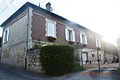
- A House at 4 Rue des Anges (20th century) [9]
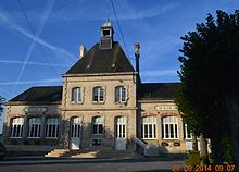
- A Town Hall / School at 7 Rue de Chavignon (1927) [10]
- A House at 8 Rue de Chavignon (20th century) [11]
- A House at 1 Rue du Chateau (20th century) [12]
- A House at 1 Place du Clos-Rubut (20th century) [13]
- A House at 1 Impasse Denne (20th century) [14]
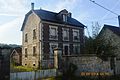
- A House at 1 Rue du Guet (20th century) [15]
- A House at 2 Rue du Guet (20th century) [16]
- A House at 5 Rue d'Hameret (20th century) [17]
- A House at 7 Rue d'Hameret (20th century) [18]
- A Town Hall / School at the Place de la Mairie (20th century) [10]
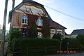
- A House at 1 Rue du Moulin (20th century) [19]
- The Creute du Caid[Note 1] (Quarry) (1917). [20]
- The Quarry Carvings (1917) [21] The Creute du Caid operated for a century and a half and was occupied by the belligerents during the First World War. They left some cave carvings - some of which are of high quality.[22]
- Aizy-Jouy Village (20th century) [23]
- The War Memorial (20th century) [24]
Religious heritage edit
The commune has several religious buildings and structures that are registered as historical monuments:
- The Parish Church of Saint-Médard (12th century). [25] The church has several items that are registered as historical objects:
- The Parish Church of Saint-Bandry (1928). [30] The church has several items that are registered as historical objects:
- All objects in the Church
 [31]
[31] - A Lectern (18th century) [32]
- A Baptismal font (13th century) [33]
- A Baptismal font (13th century) [34]
- All objects in the Church
- An Ancient Church (12th century). [35] This church was destroyed during the First World War. Only the south gate remains.
- The Communal Cemetery at Le Toty (1926) [36]
- The Communal Cemetery at Aizy (20th century) [37]
Gallery of Historical Monuments edit
-
 House at 4 Rue des Anges
 -
 The old Town Hall at 7 Rue de Chavignon
 -
 House at 1 Rue du Guet
 -
 House at 2 Rue du Guet
 -
 House at 1 Rue du Moulin
 -
 Aizy-Jouy War Memorial
 -
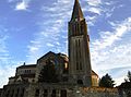 The Church of Saint-Médard
 -
 The Church of Saint Bandry
 -
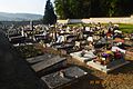 The Communal Cemetery at Aizy


See also edit
Notes and references edit
Notes edit
- ^ The term "Creute" means "quarry" in the local dialect.
References edit
- ^ a b "Répertoire national des élus: les maires". data.gouv.fr, Plateforme ouverte des données publiques françaises (in French). 2 December 2020.
- ^ "Populations légales 2021". The National Institute of Statistics and Economic Studies. 28 December 2023.
- ^ a b c Google Maps
- ^ List of Mayors of France (in French)
- ^ National Dictionary of Communes of France - Meyrat Dictionary, 17th edition, ed. Albin Michel, Paris (1959), 1350 pages.
- ^ Population en historique depuis 1968, INSEE
- ^ Ministry of Culture, Mérimée IA02002032 House at 2 Impasse des Anges (in French)

- ^ Ministry of Culture, Mérimée IA02002033 House at 1 Rue des Anges (in French)
- ^ Ministry of Culture, Mérimée IA02001650 House at 4 Rue des Anges (in French)
- ^ a b Ministry of Culture, Mérimée IA02001637 Town Hall / School at 7 Rue de Chavignon (in French)
- ^ Ministry of Culture, Mérimée IA02001649 House at 8 Rue de Chavignon (in French)
- ^ Ministry of Culture, Mérimée IA02001651 House at 1 Rue du Chateau (in French)
- ^ Ministry of Culture, Mérimée IA02001644 House at 1 Ploace du Clos-Rubut (in French)
- ^ Ministry of Culture, Mérimée IA02001645 House at 1 Impasse Denne (in French)
- ^ Ministry of Culture, Mérimée IA02001642 House at 1 Rue du Guet (in French)
- ^ Ministry of Culture, Mérimée IA02001643 House at 2 Rue du Guet (in French)
- ^ Ministry of Culture, Mérimée IA02001646 House at 5 Rue d'Hameret (in French)
- ^ Ministry of Culture, Mérimée IA02001647 House at 7 Rue d'Hameret (in French)
- ^ Ministry of Culture, Mérimée IA02001648 House at 1 Rue du Moulin (in French)
- ^ Ministry of Culture, Mérimée PA02000019 La Creute du Caid (in French)
- ^ Ministry of Culture, Mérimée IA02001636 Quarry Carvings (in French)
- ^ Quarry Carvings pictures Archived 2013-12-17 at the Wayback Machine
- ^ Ministry of Culture, Mérimée IA02001633 Aizy-Jouy Village (in French)
- ^ Ministry of Culture, Mérimée IA02001652 War Memorial (in French)
- ^ Ministry of Culture, Mérimée IA02001634 Parish Church of Saint-Médard (in French)
- ^ Ministry of Culture, Palissy IM02004133 Tombstone of Claude Personne (in French)
- ^ Ministry of Culture, Palissy IM02004132 Tombstone of François de Hanot (in French)
- ^ Ministry of Culture, Palissy IM02004131 Sculptures (in French)
- ^ Ministry of Culture, Palissy IM02004102 All objects in the Church (in French)
- ^ Ministry of Culture, Mérimée IA02001635 Parish Church of Saint-Bandry (in French)
- ^ Ministry of Culture, Palissy IM02004101 All objects in the Church (in French)
- ^ Ministry of Culture, Palissy PM02000003 Lectern (in French)
- ^ Ministry of Culture, Palissy PM02000002 Baptismal font (in French)
- ^ Ministry of Culture, Palissy PM02000001 Baptismal font (in French)
- ^ Ministry of Culture, Mérimée PA00115498 Ancient Church (in French)
- ^ Ministry of Culture, Mérimée IA02001641 Communal Cemetery at Le Toty (in French)
- ^ Ministry of Culture, Mérimée IA02001638 Communal Cemetery at Aizy (in French)
External links edit
- Aizy-Jouy on the old National Geographic Institute website (in French)
- Aizy-Jouy in the Chemin des Dames dictionary (in French)
- 40000 Bell Towers (in French)
- Aizy-Jouy Photos website
- Aizy-Jouy on Géoportail, National Geographic Institute (IGN) website (in French)
- Jouy and Aify on the 1750 Cassini Map