
KNOWPIA
WELCOME TO KNOWPIA

Albaret-Sainte-Marie 
Summary
Albaret-Sainte-Marie (French pronunciation: [albaʁɛ sɛ̃t maʁi]; Occitan: Aubaret) is a commune in the Lozère department in southern France.
Albaret-Sainte-Marie | |
|---|---|
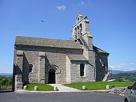 The church of Albaret | |
Location of Albaret-Sainte-Marie .mw-parser-output .locmap .od{position:absolute}.mw-parser-output .locmap .id{position:absolute;line-height:0}.mw-parser-output .locmap .l0{font-size:0;position:absolute}.mw-parser-output .locmap .pv{line-height:110%;position:absolute;text-align:center}.mw-parser-output .locmap .pl{line-height:110%;position:absolute;top:-0.75em;text-align:right}.mw-parser-output .locmap .pr{line-height:110%;position:absolute;top:-0.75em;text-align:left}.mw-parser-output .locmap .pv>div{display:inline;padding:1px}.mw-parser-output .locmap .pl>div{display:inline;padding:1px;float:right}.mw-parser-output .locmap .pr>div{display:inline;padding:1px;float:left}html.skin-theme-clientpref-night .mw-parser-output .od,html.skin-theme-clientpref-night .mw-parser-output .od .pv>div,html.skin-theme-clientpref-night .mw-parser-output .od .pl>div,html.skin-theme-clientpref-night .mw-parser-output .od .pr>div{background:#fff;color:#000}html.skin-theme-clientpref-night .mw-parser-output .locmap{filter:grayscale(0.6)}@media(prefers-color-scheme:dark){html.skin-theme-clientpref-os .mw-parser-output .locmap{filter:grayscale(0.6)}html.skin-theme-clientpref-os .mw-parser-output .od,html.skin-theme-clientpref-os .mw-parser-output .od .pv>div,html.skin-theme-clientpref-os .mw-parser-output .od .pl>div,html.skin-theme-clientpref-os .mw-parser-output .od .pr>div{background:white;color:#000}}  Albaret-Sainte-Marie  Albaret-Sainte-Marie | |
| Coordinates: 44°52′59″N 3°14′53″E / 44.8831°N 3.2481°E | |
| Country | France |
| Region | Occitania |
| Department | Lozère |
| Arrondissement | Mende |
| Canton | Saint-Chély-d'Apcher |
| Intercommunality | Terres d'Apcher-Margeride-Aubrac |
| Government | |
| • Mayor (2020–2026) | Michel Thérond[1] |
| Area 1 | 15.98 km2 (6.17 sq mi) |
| Population (2021)[2] | 554 |
| • Density | 35/km2 (90/sq mi) |
| Time zone | UTC+01:00 (CET) |
| • Summer (DST) | UTC+02:00 (CEST) |
| INSEE/Postal code | 48002 /48200 |
| Elevation | 767–1,139 m (2,516–3,737 ft) (avg. 970 m or 3,180 ft) |
| 1 French Land Register data, which excludes lakes, ponds, glaciers > 1 km2 (0.386 sq mi or 247 acres) and river estuaries. | |
Population edit
| Year | Pop. | ±% p.a. |
|---|---|---|
| 1968 | 320 | — |
| 1975 | 309 | −0.50% |
| 1982 | 333 | +1.07% |
| 1990 | 338 | +0.19% |
| 1999 | 452 | +3.28% |
| 2007 | 537 | +2.18% |
| 2012 | 569 | +1.16% |
| 2017 | 568 | −0.04% |
| Source: INSEE[3] | ||
See also edit
References edit
- ^ "Répertoire national des élus: les maires". data.gouv.fr, Plateforme ouverte des données publiques françaises (in French). 2 December 2020.
- ^ "Populations légales 2021". The National Institute of Statistics and Economic Studies. 28 December 2023.
- ^ Population en historique depuis 1968, INSEE
Wikimedia Commons has media related to Albaret-Sainte-Marie.